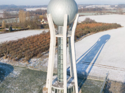
Presentation of some of the results of a research project mapping the development of the construction of elevated water tanks in the Czech Republic

This paper presents a summary of some of the results of the research project, “Water towers – identification, documentation, presentation, new utilization”, (DG18P02OVV010), which has been implemented since 2018 as part of the Programme for the Support of applied Research and Development of  National and Cultural Identity for 2016–2022 (NAKI II) of  the Ministry of  Culture of the Czech Republic. In terms of content, it follows on from articles from previous years published in this periodical, but clarifies and supplements the issues of technical terminology and typology established at its inception based 
on the knowledge gained during the project. Furthermore, it presents general results of the records of the structures of elevated water tanks and focuses on a brief description of the historical development of these structures in our territory. 

Irrigation – rediscovered heritage, its documentation, popularisation and protection based on the example of historical meadow irrigation systems

Objekty závlah byly budovány a fungují převážně jako součást většího nebo menšího funkčního celku. Jejich význam i z pohledu potenciální pa-mátkové ochrany tak roste s identifikací a dokumentací nejen solitérních staveb, ale zejména celých soustav/funkčních celků a popisem vazeb mezi nimi. Samostatný objekt či stavba nemusejí být nijak výjimečné, avšak jejich zapojení do většího funkčního celku může vytvářet unikátně pojaté řešení. V oboru vodního hospodářství se obzvlášť projevuje důležitost a význam kritérií, jako je hodnota typologická, hodnota technologického toku, autenticita formy a funkce, hodnota technologických a systémových vazeb s přesahem do zemědělství či průmyslu. Článek přináší informace o možnostech využití tradičních metod historického a archivního výzkumu a dokumentace lokalit, jakož i o využití moderních nástrojů pro plošně rozsáhlejší systémy, včetně metod digitalizace a digitálního zpracování podkladů.

On the issue of authenticity of water management structures

Authenticity, in the sense of credibility or truthfulness, is one of the key categories in heritage management. This paper focuses on the question of authenticity in relation to industrial heritage, specifically water management structures. In the case of these structures, emphasis is usually placed on authenticity of function, but two further types of authenticity are equally important: authenticity of material substance or form (in relation to the original design and the structure built on its basis), and authenticity as a consequence of historical evolution. The paper presents an analysis of four model examples of water management structures that are either legally protected heritage sites or have been proposed as candidates for legal protection. The analysis of their heritage values provides insights into the individual categories of authenticity and enables the formulation of principles for managing sites of heritage value.

Fish stocks of water elements in heritage protected complexes

The aim of this article is to present the results and conclusions of research which focused on recommending an appropriate approach for the creation and maintenance of fish stocks in various types of water elements, from small ornamental pools to formal water elements and large close-to-nature fish ponds. These elements form part of cultural monument complexes and heritage protected settlements (especially historic gardens and chateau parks, religious complexes, village and urban heritage reserves). Detailed results are described of a twoyear investigation of various types of water elements located in Kroměříž gardens, Červené Poříčí Chateau, and the former monastery in Osek, near Teplice, as examples of cultural monuments and their water elements. Issues of possible management of fish stocks, modifications of the aquatic environment to ensure stable conditions for fish farming, and the reduction of negative interaction of pollution and excessive or inappropriately chosen fish stocks and aesthetic perception of water elements are discussed. The results of the field investigations have shown an unsatisfactory state of virtually all locations due to water eutrophication, overgrowth of vegetation in some water elements, unregulated interventions in fish stocks, and uncontrolled fishing resulting in the reduction of predatory species population and the occurrence of invasive species. At the same time, a relatively low awareness of the possibilities of regulating fish stocks and of the principles of sustainable maintenance have been found.

The construction of large hydraulic structures in the context of ideas and ideologies

This paper deals with some aspects of the relationship between man and water demonstrated via the example of large hydraulic structures constructed in the Czech lands. Based on this relationship, principles of the practical functioning of ideas and ideologies, including religion, can be presented. It is not just about “pagan” cults, aiming directly at worshipping water as a living being. Christianity also significantly influenced the framework in which water management operated across the centuries and, at the same time, new ideas associated with the Enlightenment and the Industrial Revolution during the 18th and 19th centuries. A key part of the paper is focused on the topic of the construction of large hydraulic structures in the 20th century, which was particularly intensive in its second half. It also mentions political, ideological, and natural changes which were, at the beginning of the 21st century, reflected in man’s relationship with water resources and the possibilities of influencing them.

Interview with Ing. arch. Eva Dvořáková and Ing. arch. Tereza Bartošíková, Ph.D., about protection of technical and industrial cultural heritage in the Czech and Slovak Republik

As part of the December issue of VTEI, which is entirely devoted to the topic of technical and industrial cultural heritage and the “Programme of applied research and development of national and cultural identity (NAKI II)” of the Ministry of Culture, we asked for an interview with two specialists in this field, Ing. arch. Eva Dvořáková from the National Heritage Institute (Národní památkový ústav, NPÚ) and Ing. arch. Tereza Bartošíková, Ph.D., from the Monuments Board of the Slovak Republic (Pamiatkový úrad Slovenskej republiky, PÚ SR).

Use and popularisation of historical and current water management sources of information for the development of an environmentally friendly society

Since time immemorial, research in all scientific fields has brought countless new information and broadened the spectrum of current knowledge. In the past, research was made more difficult by the then possibilities of disseminating newly acquired knowledge. Many scientists in the world have asked
the same questions, proposed and tested similar hypotheses, obtained similar scientific results, and reached their own unique conclusions. The problem was the very limited possibility of sharing this new information, thus the possibility of their mutual use and very often their preservation and availability to
future generations. It is safe to say that in the history of science, a huge amount of knowledge and information was discovered that was not used enough, was discovered repeatedly, or was completely lost.

Banská Štiavnica water management system – an important UNESCO technical monument

From the 16th to the 19th century, a unique water management system was created in Banská Štiavnica and its vicinity, which served the local mines. The water management system consisted of water channels – collecting ditches, which concentrated surface water from Štiavnické vrchy (Štiavnica mountains) and brought it to the mining water reservoirs (tajchy). Tajchy are water reservoirs that were built to accumulate surface water from the collecting ditches. Water from the tajchy was discharged into water canals – transporting ditches that brought water to the shafts. Here, the water was piped into the depths of the mine, where the obtained water energy powered pumping machines that pumped groundwater out of the flooded mines. Once the groundwater was drained, the miners could continue extracting gold and silver. Water-powered processing facilities also operated in Banská Štiavnica and its vicinity, which processed the extracted
ore from the mines. For centuries, the Banská Štiavnica water management system set in motion more than a hundred water-powered devices. The system consisted of about 60 tajchy, 170 km of ditches, and 15 water tunnels.

Estimation of natural groundwater resources in hydrogeological zones in the Czech Republic under changing climatic conditions 1981–2019

In the Czech Republic, hydrogeological zones were defined as early as 1965 as a part of the regional hydrogeological survey. A hydrogeological zone (HGZ) is defined as a unit with similar hydrogeological conditions, defined tectonically and geologically, in whose territory a certain type of aquifer and groundwater circulation prevails. The boundaries of HGZs have been modified over time and their numerical hydrogeological characteristics have been determined by various methods; one of the basic characteristics is the amount of natural groundwater resources. Natural resources are the dynamic component of groundwater and are expressed in m3.s-1. They are determined by the recharge of water to the aquifer system (precipitation, groundwater overflows from other aquifers, natural infiltration of surface water, etc.). If the HGZ is hydrogeologically closed, the long-term average of its recharge from precipitation and the long-term average of baseflow can be used as an estimate of the natural groundwater resource. In the “Groundwater Rebalance Project”, estimates of natural groundwater resources in 152 hydrogeological zones in the Czech Republic were processed and are presented in the report [1]. The natural resources were determined by several different methods using data from 1971–2010 and 2000–2010. 

Impact of Teplice restoration on river basin runoff – preliminary results

As part of the project for the Ministry of the Environment of the Czech Republic dealing with the monitoring of the impact of nature­‑friendly measures on improving the hydrological regime of small river basins, the Teplice river basin in the White Carpathians has been observed. Monitoring has been taking place since 2018, the measures were implemented in 2020. Data are available for the time period before the measures were implemented and for the year 2021, on which it is possible to observe the impact of the implemented revitalization. The data show the fluctuation of the daily runoff from the river basin and its overall reduction, which is probably caused by increased evaporation from the newly formed water bodies and increased water infiltration into the underground zone. After evaluating the observed data, there was a visible reduction in the surface runoff from the basin, which may nevertheless also be caused by the low rainfall totals in 2021.

Assessment of the possibility of changing the use of dry reservoirs

The main objective of the project „Potential use of dry reservoirs in landscape water management“ was to develop a methodological guideline describing the procedure for changing the use of a dry reservoir. The methodological guideline is based on a two¬ level multi¬criteria analysis. Another aim of the project was to make a complete record of implemented dry reservoirs and polders in the Czech Republic and to present it in the form of a database and a map with professional content. Documentation of the technical condition of some existing dry reservoirs was also an important output of the project.

Measuring annual precipitation with a radar rain gauge in severe mountain conditions

The aim of this article is to describe the experience gained while using alternative technology for measuring annual precipitation in severe mountain conditions without a source of electrical energy. For this purpose, a Lufft WS100 radar precipitation sensor was installed in Šumava in 2020 at an altitude of 1270 m above sea level. The measurements so far have shown evident advantages; for example, maintenance free sensor, detailed measurement step, and distinction of the type of precipitation. The question remains how accurate the measurement is, when during some precipitation episodes the radar precipitation sensor probably overestimates its measurements. Accurate comparison with other measurements is difficult in these mountain ridge conditions. On the other hand, the radar sensor also gives accurate measurements during some precipitation episodes, which we verify by a non-heated tipping bucket rain gauge located within the station and also by measuring the height of the snow. Using these proxy data, systematic error was excluded. Measurements will continue for a more detailed evaluation. The radar sensor is, among other things, part of the monitoring of Kaplický potok in Boubín National Nature Reserve, where runoff is also monitored. From this point of view, information about precipitation and its type is important for the evaluation of the hydrological properties of the basin.  

The current version of the BILAN model

BILAN je celistvý konceptuální model v denní/měsíční struktuře (schéma je uvedeno na obr. 1), simulující složky hydrologické bilance na povodí. Přestože jeho vývoj byl nastartován ve VÚV TGM již počátkem devadesátých let minulého století, jde o model, který je v České republice stále standardně používán a zůstává přístupný laické i odborné veřejnosti. Například je nedílnou součástí řešení aplikace/systému HAMR [1], ale byl použit i jinde [2–4]. Mezi hlavní výhody modelu oproti jiným řešením patří interní kalibrační algoritmy, možnost přímého vkládání dat o užívání vod a nízká výpočetní náročnost vhodná pro variantní simulování (např. dopadů klimatické změny na vodní režim).

Invitation to the travelling exhibition Historical water management objects, their value, function and significance for the present time

Research focused on the evaluation of historical water management objects in the Czech Republic from the point of view of their significance for historic preservation is already in its fifth year. It is broadly conceived interdisciplinary research with the involvement of experts from TGM WRI, Methodological Centre of Industrial Heritage of the National Heritage Institute, Historical Institute of the Academy of Sciences of the Czech Republic, The Silva Tarouca Research Institute for Landscape and Ornamental Gardening, and Faculty of Science, Palacký University Olomouc. The research is carried out within the DG18P02OVV019 project “Historical water management objects, their value, function and significance for the present time” financed by the NAKI II programme of the Ministry of Culture. 

Annotation of the exhibition Irrigation – rediscovered heritage, its documentation and popularization

As a response to landscape drainage in the modern era, caused by the intensification of agriculture, the drying up of ponds, and land reclamation activities, interest in the opposite process has reappeared, i.e. irrigation. Existing irrigation systems, at present often non-functional and preserved only in parts, have become the subject of interest for this project which tried to capture the historical development of this specific water management field as well as part of the industry associated with the implementation of irrigation and the production of soil irrigation equipment.

Bacteria from the family Enterobacteriaceae in reused water and their antibiotic susceptibility

The aim of this study is to evaluate the presence of bacteria from the Enterobacteriaceae family (i.e. total coliforms, thermotolerant coliforms and Escherichia coli) in different types of recycled waters (grey water, rain water and reclaimed water from the public city fountains) and problems with their detection (especially ensitivity and specificity of detection methods). The species composition of coliform bacteria in purified grey waters with their antibiotic resistance are presented.

River ferries on old topographic maps

Medium and large rivers were a major obstacle to historic trade routes and trails. River ferries were one of the main ways to cross them, so their sites were considered points of strategic importance. Using old topographic maps from Austrian military mapping from 1763–1768, 1836–1852, 1876–1880, Prussian military maps from 1825 and 1877, and Czechoslovak military maps from 1953–1957, we systematically located ferries throughout the current territory of Czechia. Map keys from individual mappings were also analysed to examine how ferries are depicted on these maps. Based on the study of old topographic maps, a geographical database was created with the location of individual ferries, including the period in which the river ferry was registered. A total of 514 historical ferries were recorded on old topographic maps from military mapping throughout Czechia; another 28 ferries were identified from other available, more detailed, map sources.

Atmospheric deposition as a possible source of surface water pollution (Preliminary results of the project, part 1 – heavy metals)

Na pilotních lokalitách v Jizerských horách, Moravskoslezských Beskydech a na Českomoravské vrchovině byly v průběhu jednoho roku sledovány koncentrace vybraných těžkých kovů v atmosférické depozici a povrchové vodě s cílem určit významnost vlivu srážek na kvalitu povrchových vod v antropogenně málo ovlivněném prostředí. Dosažené výsledky ukazují, že u vybraných kovů může atmosférická depozice v některých případech představovat významný vnos do povrchových vod. Na výslednou bilanci látkového odnosu má zásadní vliv charakter prostředí a jeho zatížení v minulosti.

Food waste issues in relation to the mandatory reporting of its production for the needs of the Waste Framework Directive

From this year, European Union member states are obliged to introduce preventive measures that will reduce the amount of food waste at all stages of the food chain. This article deals with this current topic, presents possible procedures for obtaining data on food waste production at various stages of the food chain, and shows the results of our own research and analysis about the usability of these data for reporting obligations and demonstrating future reductions.

A review article of Rapid Small-Scale Column Tests

Rychlotesty v malých kolonkách (Rapid Small­‑Scale Column Tests – RSSCTs) jsou testy, které lze použít pro snadné laboratorní ověření účinnosti adsorpce mikropolutantů na vybraný adsorbent. Volba adsorbentu je nejdůležitějším aspektem při zařazení technologie adsorpce do provozu úpravny vod nebo čistírny odpadních vod (ČOV). Testy probíhají ve zmenšeném měřítku, což minimalizuje náklady na materiál i vlastní realizaci testů. Článek se zaměřuje na adsorpci na granulovaném aktivním uhlí (GAU), jelikož je to nejčastěji používaný typ adsorbentu.

Citation analysis of VTEI

The citation rate of a journal is considered an indicator of its quality. This study presents a citation analysis of the VTEI journal, published by the T. G. Masaryk Water Research Institute (hereinafter TGM WRI). The citation analysis was conducted to identify the countries and institutions of authors who cite articles published in VTEI and the subject areas in which articles published in VTEI are cited. The identification of citing articles was complicated by the wide range of forms of VTEI journal title notation, as well as errors in the Scopus database. Therefore, the search was performed in several steps and the search query was gradually expanded. Descriptive statistics methods and cluster analysis using VOSviewer software were used for the analyses. A total of 126 publications were searched in the Scopus database, but only 108 publications were included in the analysis. These 108 articles quoted 152 articles published in VTEI. The number of VTEI citations has increased from sporadic citations prior to 2009 to more than 20 citing publications in 2020 and more than 30 cited publications in 2021. The majority of citations were received by articles published in VTEI within the first six years of publication, and the citation rate for articles published between 2009 and 2021 is relatively even. Authors from 66 institutions in 16 countries, mainly in Europe, contributed to the citing publications. However, authors from the Czech Republic were dominantly involved in citations and, in many cases, these were authors of articles published in VTEI. The main areas where articles published in VTEI are cited are environmental sciences, specifically the impacts of climate change on water management and hydrology, and water quality assessment using the water footprint.

Risk assessment as a comprehensive approach to protection of drinking water sources

Drinking water supply as well as its quality form one of the basic pillars of modern society. This corresponds to the goal of the International Water Association (IWA) – good, safe and drinkable water, which enjoys consumer confidence and can be not only drunk without fear, but in which the consumer also appreciates its taste and aesthetic appearance. In order to meet these objectives, it is important to set drinking water quality requirements and also to keep the whole process of drinking water production and distribution, including all risk areas, under continuous control.

Development of citations of the magazine VTEI

This article is available in Czech only. For translation or more information on this topic, please contact author. Časopis Vodohospodářské technicko-ekonomické informace (VTEI) vychází již 63 let. Zároveň je to pět let od ukončení spolupráce s časopisem Vodní hospodářství a začátku vydávání časopisu VTEI v současné modernizované podobě. V úvodním slovu k číslu 4–5/2015, jež… Read more »

Centrum Voda (Center Water)

Centrum Voda je výzkumný projekt, který hledá řešení problémů vyplývajících z klimatické změny a jejího vlivu na vodní poměry. Snažíme se nalézat odpovědi na základní otázky, jestli dokážeme zajistit dostatek kvalitní vody nejen pro potřeby člověka, ale i pro naši krajinu, zda se zvládneme vyrovnat s přívalovými povodněmi a jak dále snižovat znečištění vodního prostředí.

Assessment of responsible water management in industrial enterprises

This article is available in Czech only. For translation or more information on this topic, please contact author. Nebývalé množství srážek, které se v České republice vyskytly v první polovině letošního roku, dávají alespoň laické veřejnosti zapomenout na problémy se suchem a nedostatkem vody z předchozích let. I přesto zůstává sucho problémem, na který je zapotřebí se připravit. V odborné literatuře… Read more »

Extreme multi-annual hydrological droughts in the Elbe river basin

The aim of the study was the evaluation of multi-year hydrological droughts in the Elbe river basin for the Děčín stream gauging station (catchment area 51 104 m2). Average monthly flows from period 1851–2000 are available for the station. For this period, we also compiled a series of average monthly precipitation and temperatures from several data sources. We calculated annual values for precipitation, temperatures and differences in annual precipitation and runoff, then we computed long-term averages and regression linear trends for change over time. The trends are only slightly upward for all three variables, but long-term fluctuations in precipitation are more significant. According to the quantified multi-year average flows and precipitation, we searched for and merged cases from which one continuous drought lasting at least 5 years is generated for both precipitation and runoff. We quantified deficit volumes for individual drought periods. The long-term average flow was chosen as the threshold flow. The hydrological drought 2013–2020 had the longest duration, almost 7 years, of all droughts since 1851 and was also characterized by the largest total deficit volume. When compared to the average annual deficit volume, it is only in fourth place. When comparing the time series of monthly flows, it turned out that cases from different periods have similar patterns and behavior.

The influence of Prague on water quality in the Vltava and the Czech Elbe

Paper deals with the development of water quality of the river stretch of Elbe between the confluence Elbe/Vltava and the Hřensko/Schmilka on the frontier Czech Republic/Federal Republic of Germany in the period 1980–2020 and with the influence of Prague City on its pollution. After the significant improvement in the period 1985–2000, the quality of water discharged through the profile Hřensko generally complies with the German level at least. Assessment of the transport budgets shows that Vltava river contributes more to the system only as having higher water discharges. Prague City contributes to the pollution of Vltava and Elbe only by discharge of phosphorus, for the rest of common pollution items it functions only as a non-significant source.

A retrospective view of the Šumperk water supply system from the 1960s to the present

In the second half of the 20th century, the long-term problem of supplying the town of Šumperk with drinking water was finally solved. New sources of drinking water supplemented the missing capacities in the form of surface abstraction from Divoká Desná within the newly built collec-tive water supply system, together with the use of sources in Rapotín and Olšany. A significant contribution to solving the problem was the recon-struction of the water supply network, water reservoir, and intake facilities, which reduced losses. An important factor that has reduced the water consumption of the population is, of course, the significant increase in water and sewerage prices in the last 20 years, which had an impact on Šumperk as well. The operational and organizational conditions of the town’s drinking water supply were negatively affected by society-wide de-velopment, which ultimately meant an increase in operating losses in the water supply network due to limited funds for the renewal and upgrading of the water supply network. The political changes in 1989 and the following period were reflected not only in the organizational conditions of the town’s drinking water supply, but also in the final consumption and price of drinking water, both in the Šumperk region and across the whole of the Czech Republic. With the example of Šumperk, it is also possible to illustrate the transformation of the water industry after 1989 and possible diffi-culties, new starting points, and challenges for its future development.

Impact of climate change on runoff and development of forest composition in the coming decades in a selected river basin in Slovakia

Climate change is a global phenomenon that affects changes in forest composition. Therefore, the article deals with changes in forest associations as a result of global climate changes. The aim of the research was estimation of change in forest associations under climate change on the runoff processes in the selected river basin. We used two land use scenarios with forest associations and two global climate change scenarios. Land use scenarios were created for the entire territory of the Slovak Republic by the Technical University of Zvolen. The outputs of the KNMI and MPI regional climate change models (both with A1B emission scenario) were used for this research. As a result of climate change, changes in forest composition can be expected.

The Výrovka river basin as a suitable area for monitoring and comparing hydrological and landscape characteristics

The Výrovka river basin, as a compact area covering 542.5 km2, is very suitable for monitoring hydrological characteristics and comparing them in different landscape types. It is located on the border of the Lower Vltava and Upper and Middle Elbe sub-basins, extending in a range of 175–555 m above sea level, with a total of six landscape types according to the typology of the contemporary landscape of the Czech Republic. Simultane-ously, there is a varied mosaic in terms of geological subsoil and soil types. There have also been major changes in land use in this basin, mainly due to intensive agricultural activity and related watercourse modifications and amelioration. Monitoring activities within the project SS02030027 ”Water systems and water management in the Czech Republic in conditions of climate change” are currently taking place in the Výrovka river basin.

BÍLINA – The story of the purple river

Ibra Ibrahimovič (1967) has been photographing his black-and-white series ”Střepy severních Čech” (Pieces of Northern Bohemia) since the early 1990s. He became known to the public as a photographer of the struggle to save the village of Libkovice in 1993, and later in 2003 with an award-winning series about farmer Rajter.
With the support of the Ministry of the Environment and TGM WRI, the book Příběh fialové řeky (The Story of the purple river) was published in 2015, describing through photographs the turbulent fate of the Bílina river, perhaps the only river in our country that is said to have burned due to pollution. Ibra Ibrahimovič takes photographs mainly on black and white film, 6 x 12 cm, and thus tries to follow the pictorial message of Josef Sudek and Josef Koudelka, who recorded the local landscape in a similar way in the 1970s and 1990s.
In his wanderings around the Bílina river, he looks for places that tell of man‘s relationship to this river, as well as those that reflect its turbulent history. His goal is to testify to what this river, which flows in the vicinity of surface lignite mines and chemical plants, looks like today, because from his childhood, he remembers it as a dark sewer stinking of phenols.

SMART WATER

”SMART WATER” is a project funded from the Norwegian Financial Mechanisms as part of the REINE programme, running from 2nd August 2021 to 30th June 2022.
The project is coordinated by the non-profit research and training centre METCENAS, o. p. s., its partner being the organisation AVAS, s. r. o., which is responsible for the dissemination and delivery of the results.

Use of SARS-CoV-2 virus monitoring in wastewater from WWTP of various categories for epidemic surveillance in the Czech Republic

The principle of wastewater diagnostics is a suitable complementary approach that can help to gain epidemiological information on a large part of the population in a non-invasive way. The course of the pandemic spread of the new coronavirus (SARS-CoV-2) has been showing a cyclical course of successive waves of Covid-19 since 2020. For this model, a systematic detection of the occurrence of its agent in wastewater is a very effective approach.

Detection of gully erosion using the method of Global Navigation Satellite Systems in the Myjava – Turá Lúka

This paper shows the partial outcomes of a study focused on monitoring gully erosion in the Myjava river basin. The study showed the progress of dynamic changes in gully erosion in the location of Turá Lúka using various surveying techniques from 2014 until present. The study shows that selection of the surveying technique depends on various criteria and the aims of the task, where each possesses advantages and disadvantages. In the case of determination of the parameters of gully erosion (volume, length, and position), one of the suitable surveying techniques is Terrestrial Laser Scanning (TLS) as well as Unmanned Aerial Vehicles (UAV), which results in a point cloud. Measurement using Global Navigation Satellite Systems (GNSS) with a GPS device is sufficient for assessing gully erosion in transverse profiles, more complex sections, or in places with built anti-erosion and stabilization dams in a gully. This assumption was confirmed based on results from field measurements of an erosion gully by GNSS technology in 2017–2021. Evaluation of the results is given in this article. The given method of mapping the erosion gully was chosen for the need for detailed profile evaluation of previously identified critical sections (transverse profiles) of the monitored erosion form based on field surveying and area scanning and for simple data processing. The simplicity of this method due to the type of task, staffing, time, and volume of data predetermines and confirms the suitability of its selection for use under the given circumstances. When choosing this measuring technique, the requirements are easy access to the measuring point and a good satellite signal for GPS devices influencing the accuracy of the measurement concerning the surrounding vegetation. Sufficient testing and comparison of available surveying techniques make it possible to efficiently and realistically select suitable effective technology for monitoring erosive forms in the landscape for a predefined purpose. Contributions of this type will help researchers of similar tasks in decision-making when choosing the most suitable landscape surveying technology.

Changes in precipitation and runoff in river basins in the Czech Republic during the period of intense warming

The basic meteorological variables that affect the hydrological regime are atmospheric precipitation and air temperature. Both fluctuate not only in the short term and in the annual cycle, but also in the long term. Long-term changes in both of these variables have the character of periodic fluctuations around the mean values. Since about 1980, there has been a systematic increase in air temperature in the Czech Republic. This article provides information on how the climate fluctuations that this change brings affect the precipitation and runoff regime in our territory.