Some aspects of catchment protection upstream of future reservoirs
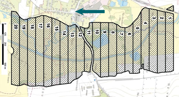
Protected areas of natural water accumulation have been long monitored and protected. So far, little attention has been paid to the catchment area which will be the future source of water for these water reservoirs from the point of view of influencing their quality. This article focuses on certain diffuse (non-point) processes that may lead to pollution and thus to limited use of accumulated water. It describes the methodology for identifying critical points in the vicinity of the future reservoir, where an excessive amount of sediment loads will enter the aquatic envi-ronment during torrential rainfall events. This will lead to sedimentation of the reservoir as well as to the input of dissolved pollutants. The methodology was applied to all 61 selected sites; the results are clearly presented in Tab. 1 and further discussed. As another non-point aspect, the representation of so-called Nitrate Vulnerable Zones within the reservoir catchment areas is evaluated. Although these areas are assessed in terms of excessive nitrate levels in water, other undesirable compounds used in agriculture may also occur there. As a third aspect, the article describes the status of the land consolidation process in the monitored catchments and discusses their contribution to catchment protection. In conclusion, it is stated that it would be necessary to enshrine into legislation the protection of LAPV catchments, especially for those reservoirs intended for drinking water supply.

Irrigation – rediscovered heritage, its documentation, popularisation and protection based on the example of historical meadow irrigation systems
Objekty závlah byly budovány a fungují převážně jako součást většího nebo menšího funkčního celku. Jejich význam i z pohledu potenciální pa-mátkové ochrany tak roste s identifikací a dokumentací nejen solitérních staveb, ale zejména celých soustav/funkčních celků a popisem vazeb mezi nimi. Samostatný objekt či stavba nemusejí být nijak výjimečné, avšak jejich zapojení do většího funkčního celku může vytvářet unikátně pojaté řešení. V oboru vodního hospodářství se obzvlášť projevuje důležitost a význam kritérií, jako je hodnota typologická, hodnota technologického toku, autenticita formy a funkce, hodnota technologických a systémových vazeb s přesahem do zemědělství či průmyslu. Článek přináší informace o možnostech využití tradičních metod historického a archivního výzkumu a dokumentace lokalit, jakož i o využití moderních nástrojů pro plošně rozsáhlejší systémy, včetně metod digitalizace a digitálního zpracování podkladů.
The alternative detemination of R-factor (Rainfall erosivity factor) in the Husí Creek catchment
Hodnocení erozní účinnosti deště je v současnosti těžištěm výzkumu v oblasti stanovení erozního ohrožení půdy. V rámci empirického modelování pomocí modelů rodiny USLE (the Universal Soil Loss Equation) je erozní účinnost deště reprezentována tzv. R faktorem, jehož hodnotu lze stanovit řadou doporučených postupů. Tento článek představuje možné alternativní způsoby určení hodnoty R faktoru na základě ročních a měsíčních sum srážkových úhrnů.

Bottom level estimation of water management infrastructures from historic project documentations
Monitoring and maintenance of water management infrastructure require knowledge of their reference state characterizing their design parameters. The reference state is derived primarily from the available project documentation, which is appropriately chosen to be converted to a digital model of the bottom terrain.
Possibilities of extrapolation of digital terrain model raster DMR 5G
Airborne laser imaging (LiDAR) has been carried out throughout the Czech Republic, enabling the creation of raster of digital model of terrain. This material is widely used in various fields. From the point of view of hydrology demands, however, the shortcoming of this technology resides in the absence of accurate/complete channel topography due to the absorption of the near-infrared laser beams by water.
The accuracy of flood extent simulation by an alternative tool – AIZM
The estimation of the extent of inundations is enabled by methods of physical and mathematical modelling which have been developing for many years. Increasing accuracy, related to precise measurements, demands higher computing capacity and more time.