SUMMARY
Medium and large rivers were a major obstacle to historic trade routes and trails. River ferries were one of the main ways to cross them, so their sites were considered points of strategic importance. Using old topographic maps from Austrian military mapping from 1763–1768, 1836–1852, 1876–1880, Prussian military maps from 1825 and 1877, and Czechoslovak military maps from 1953–1957, we systematically located ferries throughout the current territory of Czechia. Map keys from individual mappings were also analysed to examine how ferries are depicted on these maps. Based on the study of old topographic maps, a geographical database was created with the location of individual ferries, including the period in which the river ferry was registered. A total of 514 historical ferries were recorded on old topographic maps from military mapping throughout Czechia; another 28 ferries were identified from other available, more detailed, map sources.
INTRODUCTION
Large rivers embody a natural landscape barrier that has always had a significant influence on the management of transport networks. Sections suitable for safe crossing of such a barrier were important strategic and trading places, and therefore are used in history as fixed points in the reconstruction of the course of old roads and trails [1]. Even in the first half of the 19th century, stone bridges were rare; some wooden bridges were unmaintained and dangerous, so fords were one of the possible ways of crossing rivers. On larger rivers in sections with greater depth, it was already necessary to provide transport in another way, usually by river ferry or boat. The operation of ferries was originally part of the landowners’ privileges, and a fee was collected from the ferryman for the transport of people, goods, and cargo.
In 1870, the Imperial Water Act was adopted, by which the operation of ferries became a licensed business [2] and three regional laws for individual administrative territories. The Czech Land Act No. 71/1870 applied to Bohemia on how to use, collect and protect against water; for Moravia, the Moravian Land Act No. 65/1870 on the use and operation of waters and protection against them; and for Silesia, the Silesian Land Act No. 51/1870 on the use and operation of waters and protection against them. The Moravian and Silesian water laws differed from the Czech law only in some details [3].
With the gradual development of technical knowledge and construction technologies, bridges became the dominant option for crossing watercourses, and ferries were preserved only in places where bridge construction was not possible for technical or economic reasons. In Czechia, ferries are currently also operated on some more important water reservoirs. In urban areas in particular, ferries currently serve as part of public transport [4, 5], which is not only about preserving a certain tradition in the transport system, but also about the practical effect of reducing transport time for daily commuting and, at the same time, as an attraction in the tourism industry. Ferries thus compensate for the lack of bridges that would facilitate the movement of passengers between specific destinations on opposite banks of rivers. Tourist demand is another driving force that is crucial to maintaining the operation of river ferries, as they offer passengers a unique waterscape experience that is outside of today’s dominant forms of transport [6, 7].
Old topographic maps are a valuable source of information about the state of the then landscape, and, simultaneously, can be applied in geographical, historical, and landscape-ecological research. In Europe, topographic maps are usable from the mid-18th century, when the first medium-scale maps
(around 1 : 25 000 to 1 : 30 000) began to appear. Since the mid-19th century, topographic maps achieved a relatively solid positional accuracy of around 25 m due to high-quality cartographic and geodetic foundations [8]. These maps are used in a wide range of research areas; in the case of rivers and water bodies, the historical connections of the development of water bodies and ponds [9], historical development of the river network [10], and historical identification and registration of water management objects [11] are most often examined. Systematic identification and registration of all sites with ferry operations has not yet been published in the Czech Republic. Some historical works dealt with specific sections of rivers, while their methodology for the identification of ferries was mainly based on archival sources [12, 13]
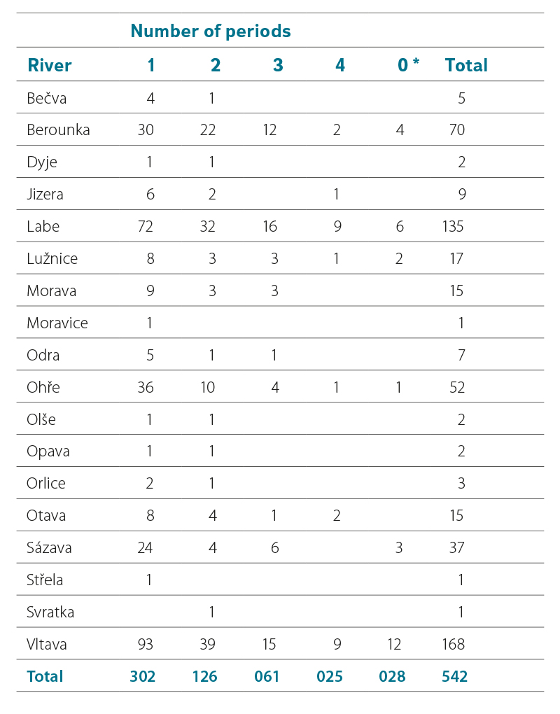
Due to the relatively simple equipment required for ferry operation, which consists of the vessel itself, two embarkation piers or entrances into the water, and a guide rope, ferries can easily come and go (Fig. 1). Slight changes in the ferry location can thus be caused by morphological changes in river beds or banks [14], or by changes in the settlement structure of villages and towns.
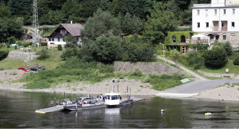
Fig. 1. A ferry for motor vehicles on the Elbe river in Dolní Žleb
The main objectives of this article include:
- researching the method and form of displaying river ferries on old topographic maps of individual military mapping,
- identification of all ferries recorded on old topographical maps on the area of the present-day Czechia and the creation of a map database of these sites,
- verification of the suitability of old topographical maps as one of the essential sources for recording the historical ferry sites.
METHODOLOGY
The identification and registration of ferries was carried out using map sets of old topographical maps in a GIS environment. The following map files were used:
- 1st Austrian Military Mapping 1 : 28 800 (1763–1768)
- 2nd Austrian Military Mapping 1 : 28 800 (1836–1852)
- 3rd Austrian Military Mapping 1 : 25 000 (1876–1880)
- Prussian military maps 1 : 25 000 (1825, 1877)
- Czechoslovak military topographic maps 1 : 25 000 (1953–1957)
The maps of the 1st Austrian mapping were created for the territory of today’s Czechia in stages for the individual historical Czech lands (Silesia 1763, Bohemia 1764–1767, Moravia 1764–1768). The relatively poor positional accuracy of these maps is caused by insufficient cartographic foundations; the average deviation of georeferenced maps reaches up to 300 m.
The maps of the 2nd Austrian military mapping were created on the territory of Moravia and Silesia between 1836 and 1852, and on the territory of Bohemia between 1842 and 1852. These maps are based on the geodetic network, used in the surveying of cadastral maps; the positional accuracy is 25–30 m.
The maps of the 3rd Austrian military mapping were created on our territory between 1876 and 1880. These maps already capture the boom of industry, the construction of railway lines, road networks, and the dynamic growth of settlements. Approximately two-thirds of the map sheets are available in the original colour version; the remaining third has been preserved in black and white.
Czechoslovak topographic military maps from 1953–1957 were, after more than 80 years, the only complete cartographic set that was completed on the entire territory of the current Czechia. It is a positionally accurate cartographic work that used a uniform system of mapping and sheet layout for the socialist countries in Europe.
In the area of Hlučínsko, which was not part of Austrian Silesia in the 19th century, cartographic sources of Prussian provenance were used, namely military topographic maps from 1825 and 1877. These maps were georeferenced with a geodesic accuracy of 25 m.
The Basic Database of Geographical Data (ZABAGED) of the Czech Office for Surveying, Mapping and Cadastre was used to identify the ferries currently operating in Czechia. These data were verified on the basis of information from the State Navigation Administration.
Other auxiliary cartographic and archival sources were also used to identify the ferries; for example, detailed 1 : 10 000 topographic maps from 1957–1971, which are not yet available in a georeferenced form for the entire Czech Republic, reambulated maps from the 1930s and 1940s in 1 : 25 000 scale, 1 : 5 000 derivative state map taken since 1955, publicly available aerial photographs from the 1930s and 1950s. The location of the objects was also verified on the basis of current aerial photographs and basic maps at a scale of 1 : 10 000.
First, the map keys for individual periods were analysed, then the structure of the ferry database was designed, and in the last stage, vectorization was carried out using specific maps from individual periods.
The ferries were mapped according to the importance of the watercourses, always from the confluence or the border of the Czech Republic to the source area. During the identification of ferries, specific watercourses were monitored based on expert knowledge of their territory and width, presented in current and old topographical maps. Ferries operating on water reservoirs are registered at the watercourses that feed these reservoirs.
In addition to the use of classic map markers, toponyms which denoted the ferry in the German and Czech languages were used. Ferries were considered identical in the historical cross-section if the objects were located at a distance of less than 50 m. If the distance between ferries in different time periods was greater than 50 m, these sites were recorded separately. For the period
1953–1957, the location of the ferries was specified using old aerial photographs.
Based on the above-mentioned process, a database of river ferries in Czechia was prepared in the form of a point layer in the S-JTSK coordinate system; this includes the name of the ferry, location by the river, cadastral territory, data on latitude and longitude, existence or non-existence of the ferry in time periods according to mapping, and information about auxiliary resources.
RESULTS
Cartographic analysis of the way ferries are depicted on old topographical maps
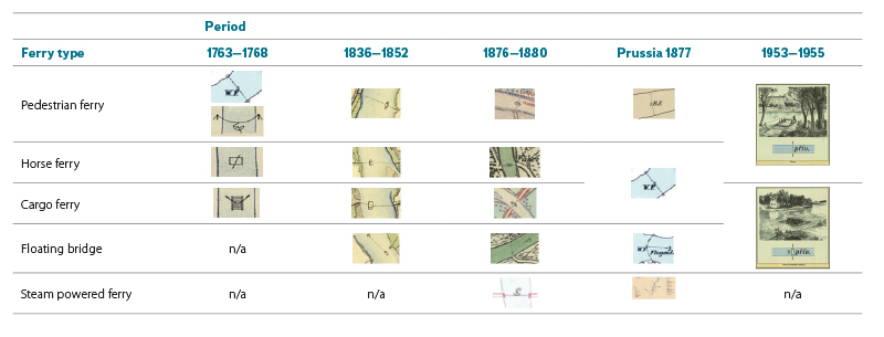
Based on the analysis of the map keys of the individual mappings, the following types of ferries were identified: pedestrian ferries (Austrian military mapping: Überfuhr für Menschen, Prussian military mapping: Kahn-Fähre), horse ferries (Austrian military mapping: Überfuhr für Pferde), cargo ferries (Austrian military mapping: Überfuhr für Wagen). A specific map mark is the so-called floating bridge (Austrian military mapping: Fliegende Brücke), which consists of the firm anchoring of a ship or ferry in the middle of the river and the fixation of the vessel on a rope (Tab. 1). The maps of the 3rd Austrian Military Mapping also contain all three categories of ferry types (Überfuhr), including designations for steam-powered ferry (Dampffähre), and railway ferry (Eisenbahntrajekt). This legend is universal for the entire territory of the former Austria-Hungary; however, both of the latter types of ferries did not occur in the territory of today’s Czechia.
Tab. 1. Cartographic signs for ferries in the legends of old topographic maps
Spatial distribution of historical ferry sites
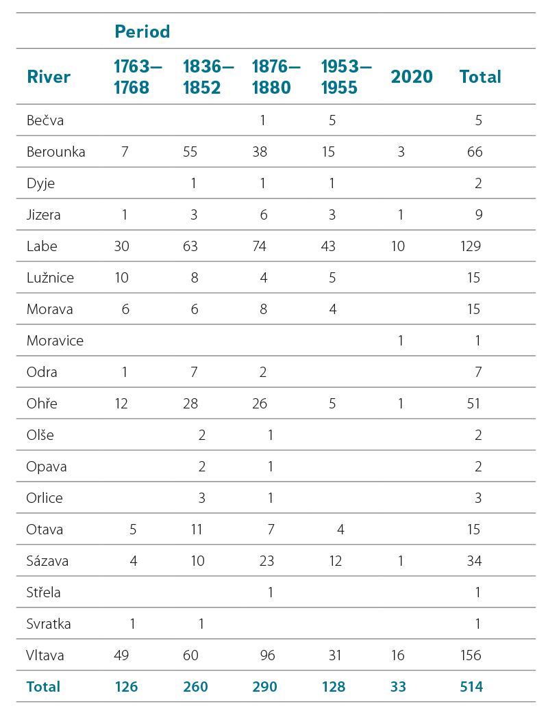
The database currently contains a total of 542 historical ferry sites on the territory of today’s Czechia, of which 514 come from identification on maps created as part of individual military mapping. The remaining ferry sites were identified only from auxiliary sources without actually appearing on military topographical maps. An overview of the number of ferry sites by watercourses for each time period is shown in Tab. 2.
The highest number of ferries was identified on military maps from 1876–1880, with more than half (56.4 %) of the total number of ferry sites in operation during this period. A similar figure (50.6 %) was also recorded in the earlier period 1836–1852. In terms of other time periods, the numbers of identified ferry sites were significantly lower, with approximately the same number of sites recorded on the 1763–1768 and 1953–1955 maps; however, only 33 (6.4 %) of them currently have a ferry in operation. Ferries were identified on a total of 18 different watercourses. The significantly highest number of sites were discovered on the two largest watercourses, i.e. the Elbe and Vltava (55.4 %); a significant number of ferries were also recorded on the Berounka and Sázava. No other river was found to have more than 15 ferry sites. Fig. 2 shows a clear spatial imbalance in the distribution of ferries within Czechia. The majority of ferries were located in the western part of the country (the Elbe basin), while only 35 (6.8 %) were located in the eastern part (the Morava and Odra basins).
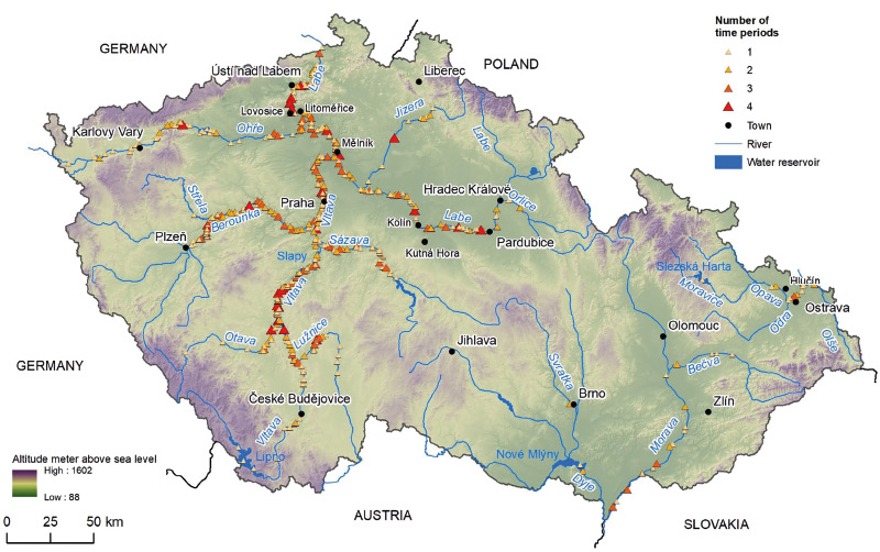
Fig. 2. Number of periods of ferry operation in Czechia based on the study of old topographic maps, see Tab. 2
Tab. 2. Numbers of ferries per river identified in each time period
During the entire research, we did not identify a ferry that was present on all the maps in all five examined periods (Tab. 3). Only 4.6 % of ferries (25) were recognized in four time periods, mostly on the Elbe and Vltava rivers (9 sites each). Oseček on the Elbe river, which is still in operation today (Fig. 3), can be cited as one of the examples of a ferry recorded on four topographical maps. A substantial number (55.7 %) of the ferries in the database appeared in only one of the periods and was no longer present in the others. As for important rivers (15 or more ferries), the largest representation of sites with ferries can be found on the Ohře river (69.2 %).
Tab. 3. Stability of recognized sites per river: the numbers of time periods related to the counts of ferries on the maps
* Sites registered only on the basis of auxiliary sources, without occurrence in military mapping.
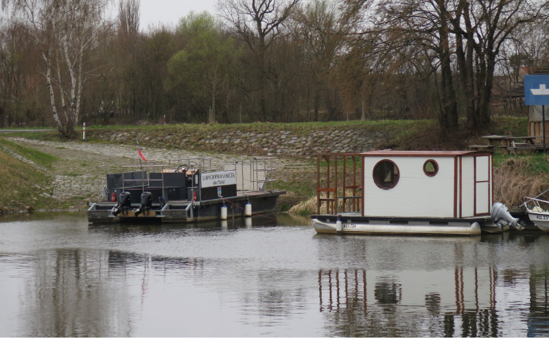
Fig. 3. The Oseček ferry on the Elbe river has been operating (with a short break) since 1836
Verification using navigation charts and water books
The explanatory power of topographic maps is influenced by various aspects, whether objective (i.e., based on the scale of the map, the map key, and its designation) or subjective (which includes the creator of the map responsible for recording relevant features in the landscape). The aim of this chapter was to at least partially assess the reliability of the applied research methodology by comparison with other sources indicating the existence of ferries in similar time periods and territorial units. Due to the lack of accurate sources in previous periods, verification was only feasible for the period between 1953 and 1955, when two possible alternatives were recognized representing sources of information that were not based in any way on topographic maps.
Navigation charts for the Elbe between Lovosice and Kolín and for the Vltava beyond Prague
Valuable historical material are navigation charts (Fig. 4), which were provided by the National Archives of the Czech Republic [14]. The maps contain data and kilometre locations of operationally important factors facilitating safe navigation on navigable rivers, while the last update took place at the end of 1950. We used these chart to compare results from the Elbe area between Litoměřice and Kolín, and from the middle and lower part of the Vltava. The area of the middle Povltaví region underwent major changes between 1950 and 1955, when large-scale water structures were built, including Slapy reservoir, at the time the largest reservoir in the Czech Republic [16]. The navigation chart relating to this area was thus no longer relevant for verification.
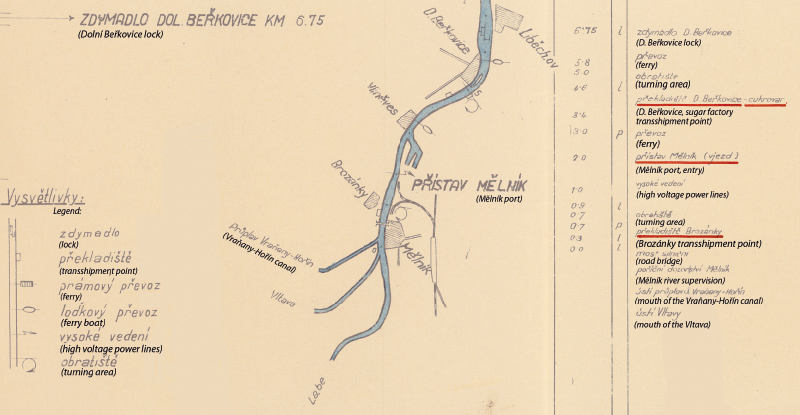
Fig. 4. An excerpt from a navigation chart and its legend (left bottom corner); the ferry signs are on the third and the fourth lines
The Elbe navigation chart covers 83 km of the watercourse between Mělník and Kolín, and about 50 km from Mělník to Lovosice. The comparison on the lower Vltava was made for 44 km between Prague-Troja and the confluence with the Elbe near Mělník (navigable km 201 to 245). The results are shown in Tab. 4.
Tab. 4. The numbers of ferries in the navigation charts and in the database of ferries
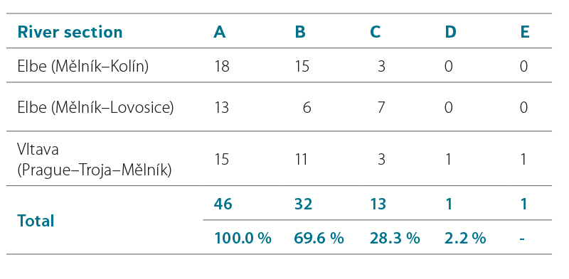
The agreement between the information coming from old topographic maps, on the one hand, and data from the navigational charts, on the other hand, was approximately 70 %, if we also take into account the time aspect. If only the location of the ferry sites were taken into account, the agreement reached more than 97 %. Only one of the ferries (2.2 %) was identified in the navigation charts, while it was completely missing in the database. However, we also came across a ferry shown on the topographic maps but not recorded on the navigation chart.
Water books for the Middle Posázaví region in the 1950s
Tihelka presented a map of ferries in the central Posázaví region for the Kutná Hora region in the last period of their existence in the middle of the 20th century [13]. He based his work on the official records of the so-called Water Books, which were kept at individual district offices and contain, among others, valid licenses for the operation of individual ferries. All sites mentioned in Tihelka’s work were also identified using our methodology, but in many cases not with exact time determination. In the 1 : 25 000 maps, the ferries of Soběšín, Samopše, Sázava, Radvanice, and Rataje nad Sázavou, listed by Tihelka as having disappeared by 1952, 1953 or 1955, are missing. On the other hand, we identified the Střechov nad Sázavou ferry for the period 1953–1955. It is possible that these ferries were no longer actually operated at the time the military maps were issued, although they still had a valid license, as most of them are still marked on reambulated maps from the previous decade. However, a decade later, some of them even appeared on more detailed military maps at a scale of 1 : 10 000. In the same way, Tihelka also mentions the Ledečko ferry, which ceased to exist by 1956, but according to data from the Directorate of Roads and Highways of the Czech Republic (ŘSD), it was already replaced by a bridge around 1932.
DISCUSSION
When examining the ways of depicting ferries on various old maps relating to the central European area, we found that ferries are depicted in different forms and that, at the same time, different categories of ferries can be distinguished in some periods. Criteria enabling such a distinction included, for example, the mode of transport (passenger or cargo), specific type of ferry (boat or barge) and, in the 20th century, parameters determining the carrying capacity of the ferry. A total of 542 ferries were identified in Czechia, of which 514 were found on old topographical maps. The most significant problems were related to the identification and location of ferries on the maps created by the 1st Austrian military mapping (1 : 28 800), where the poorer quality of some preserved copies and, above all, the rather problematic mapping methodology (which lacked precise geodetic foundations [17]) did not always guarantee sufficiently accurate location.
A set of very interesting data can be obtained from the results of the analysis of the temporal continuity of the existence of individual ferries. The results showed that no ferry was identified at one and the same place in all monitored periods, despite the positional tolerance of 50 m. This is mainly due to two factors: the very small number of ferries (33) currently in operation and the generally dynamic manifestations of changes in river flows in the landscape [9]. Approximately 56 % of detected ferries were recorded in only one time period, while some watercourses show an even higher proportion (Ohře river about 70 %). In contrast, some ferries were found to have existed for a long time, being identified on four different mappings from the mid-18th century (9 on the Elbe and another 9 on the Vltava). However, it should be noted that our data are limited to the mapping period, which means that any changes that occurred outside of these mappings may not have been captured.
An integral sub-theme of the research was the verification of information obtained both from topographic maps and from other auxiliary information sources. A comparison of the objects identified in the topographical maps and in the navigation charts of the Elbe and Vltava showed a correlation of almost 70 % of objects. With the exception of one object, all missing ferries were recorded at least on maps from an earlier period. As the concurrent analysis of the Water Books from the 1950s showed, the difference of 3–5 years between the topographic map and the navigation chart corresponds to the period of mass closure of many ferries. This is also supported by the fact that a number of missing sites were recorded during the 3rd Austrian mapping, reambulated in the 1930s and 1940s. In our research, these maps were used as an auxiliary source. In this context, it should be emphasized that the 1950s embodied a time of rapid social and economic change, as it followed the communist coup of 1948. The mentioned social processes included, among others, the motorization of the country and the improvement of the accessibility of settlements. The latter trend consisted of several conceptual steps, one of which was the construction of larger permanent bridge structures across rivers that replaced ferries [18, 19].
CONCLUSIONS
A total of 542 ferries were found in Czechia from 1763 to 2022, of which 514 were on old topographic maps and another 28 were based on auxiliary sources. Therefore, we can say that old Austrian and Czechoslovak military topographic maps embody a valuable source of information in terms of identifying historical ferries. However, certain limitations should also be noted:
The maps of the 1st Austrian military mapping show considerable positional inaccuracy, especially in terms of the cartographic depiction used and the quality of the map copies, which are about 250 years old;
The content was processed by different cartographers, which means that there may be differences in recorded details across map sheets;
Each map captures conditions at a specific time, suggesting that during the long periods of time between maps, some ferries may have come and gone without being recorded.
Despite these shortcomings, our database still represents the most extensive set of identified ferry sites in Czechia. As such, the dataset can provide valuable support to researchers in the field of historical geography, especially those focusing on the study of historic transport links and investigating the functional connections between settlements, large industrial facilities, and/or recreational activities.
The actual continuity of a specific object can only be determined on the basis of a comprehensive study of archival sources on the operation of the ferry, licenses and concessions, revisions, procedures for the construction of bridges in the vicinity, flood damage related to both the ferry and bridges, age-related deterioration, and other aspects. The same assumption also applies to the study of the driving forces that led to the creation or, conversely, the closure of ferries.
Importantly, the database opens the way to future geographical research of ferries, especially their spatial distribution along rivers and their relationship to various physical-geographical factors including, among others, orography, watercourse size, watercourse dynamics in floodplains, and soil cover composition. Within socio-economic geography, the functions of ferries can be analysed in terms of settlement growth and regional economy (such as industry and trade). Another viable topic is to explore ways of using recognized sites as points of interest to promote tourism in rural regions.
Acknowledgements
This article was made at CDV with the use of financial support provided from the Ministry of Transport as part of the programme of long-term conceptual development of research institutions (decision No. 1-VO/2021); in VÚKOZ the work was co-financed by the Ministry of the Environment (VUKOZ-IP-00027073). This partial study is based on a comprehensive article about ferries in the Czech Republic, which was published in English in the journal Water in 2021.
The article has been peer-reviewed.
