SUMMARY
As part of the project for the Ministry of the Environment of the Czech Republic dealing with the monitoring of the impact of semi-natural measures on improving the hydrological regime of small river basins, the Teplice river basin in the White Carpathians has been monitored. The monitoring has been taking place since 2018, the measures were implemented in 2020. Data are available for the time period before the measures were implemented and for the year 2021, on which it is possible to see the impact of the implemented restoration. The data show the fluctuation of the daily runoff from the river basin and its overall reduction, which is probably caused by increased evaporation from the newly formed water bodies and increased water infiltration into the underground zone, which, however, is not supported by monitoring. Based on the evaluation of the obtained data, a visible reduction of the surface runoff from the basin was found, which may nevertheless also be caused by the low rainfall totals in 2021.
INTRODUCTION
Unsparing interventions in water regime significantly affect runoff from a basin. This mainly concerns the method of agricultural management and land drainage, canalization of watercourses, inappropriately designed anti-flood measures and, last but not least, the method of land use (impervious surfaces, buildings with roof drainage, etc.). In addition to anthropogenic influences, nature currently has to come to terms with the impact of climate change, which manifests itself mainly in the rise in air temperature with the consequence of increased evapotranspiration of water, and subsequently the limitation of runoff and recharge to soil and groundwater. These manifestations increase the risk of longer dry periods [1, 2].
To avoid the negative consequences of anthropogenic influences and the impact of climate change on the overall water status, it is necessary to strengthen water retention in the landscape; therefore various forms of increasing water retention in the landscape are an integral part of adaptation measures designed to limit the negative impact of climate change. Comprehensive implementation should also include such measures regarding the use of land that would directly prevent the accelerated runoff of water from the landscape. One of the means to retain water in the landscape are semi-natural measures, which can, by increasing the infiltration of water in the floodplain on a local scale, slow down the runoff from the catchment and thus strengthen the groundwater resources. Another benefit can be an increase in air humidity in the immediate vicinity of newly constructed water bodies, which has a positive effect on the neighbouring ecosystem.
The article summarizes the results of hydrological monitoring in the Teplice river basin in the White Carpathians. The monitoring has been ongoing since 2018, semi-natural measures were implemented in 2020. Changes in the behaviour of the hydrological regime before and after the implementation of the restoration are documented on the data obtained by measuring the runoff from the basin.
METHODS AND DATA
Project “Drought – monitoring of semi-natural measures”
As part of the project “Drought – monitoring of semi-natural measures” for the Ministry of the Environment, a comprehensive monitoring of watercourses and land in their catchment areas was carried out in the Czech Republic in order to evaluate the impact of the implementation of restoration measures to protect against the impact of drought. For the purposes of evaluating their influence, it is necessary that the subject areas and sites be comprehensively monitored even before the implementation of the individual measures begins due to the impact on the initial state of the natural system, while monitoring should continue for several years after the implementation of the proposed measures. Monitoring of watercourses and catchment areas took place in sites where semi-natural measures were planned to be implemented within a time horizon of one to three years, i.e. in 2017–2019. These were monitoring techniques guaranteeing the determination of hydrological and hydroecological properties of watercourses, including water quality and soil properties of the affected sites [3].
Teplice catchment
The area of interest of the Teplice catchment (Fig. 1) is located in the White Carpathians PLA in the South Moravian region, in the eastern part of the Hodonín district. The closing profile with the water gauging station is located in Slovakia, 100 m from the state border with the Czech Republic. The altitude of the basin ranges from 340 to 631 m above sea level. Teplice springs south of the village of Kuželov near the Czech-Slovak state border. The two more significant left-hand tributaries in the basin are Javornický potok and Rybnický potok. Teplice, as Teplica, flows further through the territory of Slovakia and flows into the Myjava river near the village of Senica. It then flows into the Morava River south of Břeclav at the triple border of the Czech Republic, Slovakia and Austria.
The area of the Teplice basin to the closing profile of the water gauging station is 17.57 km2. There are forests (6.05 km2), agricultural land (9.39 km2) and pastures (2.13 km2) in the catchment area.
In the monitored period 2018–2021, the average runoff from the basin was 16 l/s.
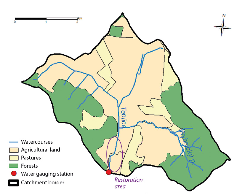
Fig. 1. Teplice catchment
Teplice restoration
The implementation of the restoration took place in 2019–2020. The project was co-financed by the European Union – the European Fund for Regional Development within the Operational Programme Environment, and the managing body of the Ministry of the Environment.
The part of the Teplice watercourse south of the village of Kuželov was modified and straightened in the past to prevent agricultural land from becoming wet. The runoff from the basin was thus accelerated. The restoration of the channel aimed to carry out eco-stabilization interventions that will contribute to the retention of water in the landscape and to the improvement of the overall hydrological situation of the area. The project was supposed to lead to the restoration of natural processes and to the strengthening of biodiversity in the White Carpathians PLA.
Fig. 2 shows a comparison of the morphology of the watercourse on orthophoto maps from 2018 with the Teplice channel still straight, and from 2021, where the completed reopening of the Teplice channel in the landscape is supplemented by newly established water bodies. The photo in Fig. 3 comes from the time of implementation, while Fig. 4 documents the state after the completion of the restoration works.
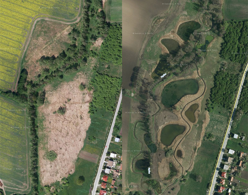
Fig 2. On the left is the area of interest before the implementation of the measure (2018), on the right after the completed restoration (www.mapy.cz)
Hydrological monitoring and data
The restoration of Teplice in the area of interest near Kuželov took place in 2020. The hydrological monitoring of TGM WRI took place before the implementation of the measures in 2018 and 2019, then during the implementation in 2020, and continues after its completion. The year 2021 was the first year suitable for evaluating the effect of the measures on the hydrological regime.
The runoff from the basin is continuously monitored by a water gauging station, equipped with a sensor with a pressure sensor and a built-in microprocessor compensating for the temperature dependence of the sensor and its possible non-linearity, which records the height of the water level in the measuring profile. The conversion of water level to flow rate takes place on the basis of the specific flow rate curve determined by hydro metering. The data on precipitation and air temperatures used to monitor hydrometeorological conditions in the basin are taken from the Czech Hydrometeorological Institute database, namely from the adjacent climatic stations Velká nad Veličkou (B1VELV01_SRA; 289 m above sea level; 6.5 km from the closing profile) and Strážnice (B1STRZ01_T; 176 m above sea level; 15 km from the closing profile).
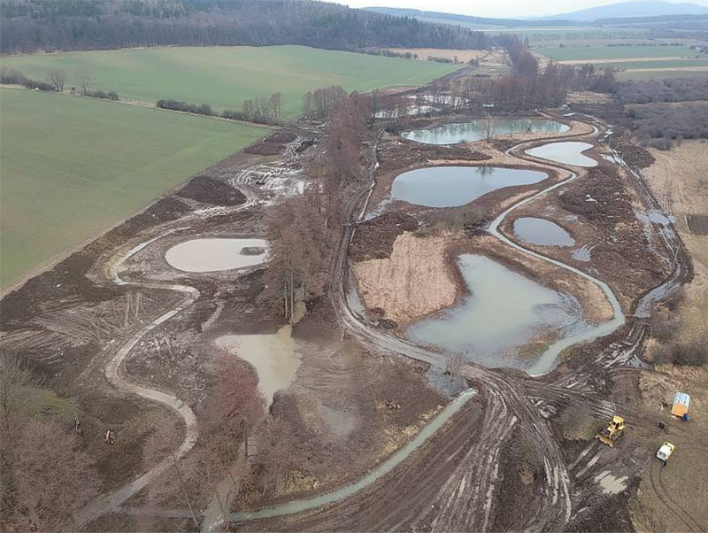
Fig. 3. Implementation of measures, 2020
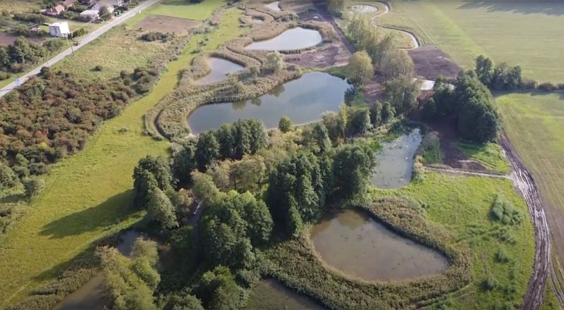
Fig. 4. Completed restoration, 2021
Estimation of evaporation from the water surface
The estimation of evaporation from the water surface of new water bodies created during the restoration was based on the simplest empirical relationship, requiring only measured values of air temperature [4]. This relationship, expressed by the formula below, was derived based on the dependence of observed evaporation and air temperature at the Hlasivo station in 1957–2018. Formulas using global solar radiation, water temperature, or a combination thereof, give more accurate results, however, we did not have these measured quantities available and the purpose was to provide an approximate estimate for which the given relationship suits us.

where:
VVH is evaporation from the water surface
Tvzd mean air temperature [°C]
Furthermore, a Slovak formula (frequently used in the past) was used to calculate the evaporation from the water surface, in which the evaporation is also dependent on the air temperature [5]:

The formulas calculate the daily value of evaporation in millimetres; in the c,0452*Tvzd – 0,204) ase of calculation using the average monthly temperature, the result must be multiplied by the number of days in the given month.
RESULTS AND DISCUSSION
Fig. 5 shows a graph with the daily course of flows and precipitation totals from 1st January 2018 to 31st December 2021. Hydrological characteristics for the monitored period are shown in Tab. 1. The long-term mean precipitation total in 1961–1990 was 750 mm [6]. In 2018 and 2019, there was below-average precipitation of 612.8 mm and 661.9, respectively. 2020 was above average with 838.8 mm, while in 2021 the precipitation total was only 547.2 mm. The mean air temperature for the reference period 1961–1990 was 7.5 °C. In the monitored period, it was 11.24 °C (2018), 10.98 °C (2019), 10.52 °C (2020), and 9.68 °C (2021), with an average flow in the closing profile of 16, 4 l/s, and then 13.4 l/s in 2018, 115.4 l/s in 2019, and 19.3 in 2020. After the restoration, in 2021, the average annual flow in the closing profile reached a value of only 13.9 l/s.
A detailed look at the daily course of the water flow through the closing profile (Fig. 6 and 7) shows a significant fluctuation during the day, which began to appear after the completion of the restoration. The highest flows occur in the afternoon between 12:00 and 18:00 and the lowest in the morning between 2:00 and 8:00. These intraday differences amount to a maximum of 30 to 40 l/s.
The reopening of the watercourse took place on a 1.5 km long section of the previously straight channel, the length of which was extended to 2.6 km. The result of the restoration was pools with a surface area of approximately 25,000 m2. At an average air temperature of 21 °C in the summer months, about 140 m3 of water evaporates from this area per day, which when converted corresponds to a flow rate of 1.6 l/s. However, this water loss is twice as high due to plant transpiration. It can therefore be said that the loss of water through evaporation from water bodies amounts to approximately 3 l/s on warm days. Due to the increase in the groundwater level in the restored section, it can be assumed that the entire area of the restored section (i.e., not only the water surface), and the extended channel of the watercourse can be included in the evaporation area. Based on the monitoring, an increase in evaporation from the water surface in the restored section can be clearly confirmed. The impact on the groundwater recharge was not monitored, so it cannot be substantiated.
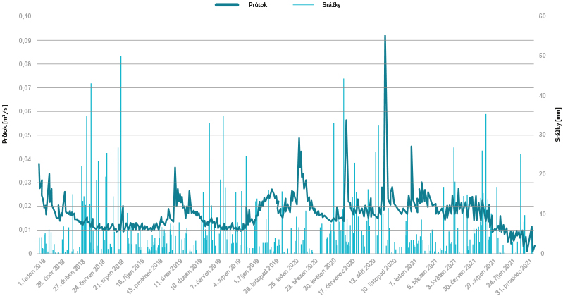
Fig. 5. Flow and precipitation from 1st January 2018 to 31st December 2021
Tab. 1. Hydrological characteristics of the basin in daily steps (sum of precipitation, mean air temperature, mean flow)
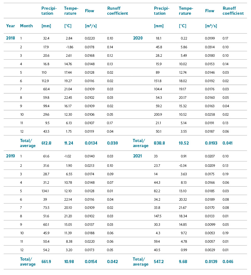
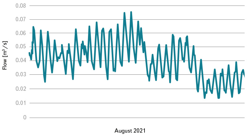
Fig. 6. Flow fluctuations after implementation of restoration (sample data – August 2021)
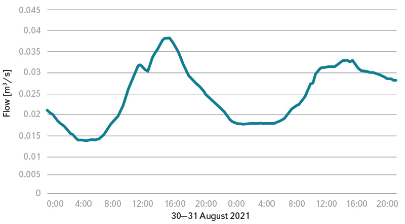
Fig. 7. Daily course of runoff (sample data – 30 and 31 August, 2021)
CONCLUSION
Hydrological monitoring of the Teplice basin showed differences between the runoff characteristics from the basin before and after the implementation of semi-natural measures. The measurement of the water flow in the water gauging station in the first year after the restoration showed in particular the daily fluctuation of the runoff from the basin due to the increased evaporation from the created water bodies and the reopened channel. Confirmation of the effect of evapotranspiration on the fluctuation of water runoff from the basin in the day/night regime can also be confirmed by the research of Kovář et al. [7], who studied the evapotranspiration of riparian vegetation in the dry season on Starosuchdolský potok in Prague. This phenomenon was also described in [8]. The increased infiltration of water into the underground zone probably has an effect on slowing down the runoff from the basin, however, groundwater level monitoring was not part of the project, so this assumption cannot be confirmed. It is also necessary to mention that in 2021 the precipitation total in the basin was below average at 547.2 mm.
The article analysed data for a relatively short period of time, so these are preliminary results. The monitoring of the site will therefore continue in the future, so that the research results so far can be confirmed on the basis of data obtained through long-term monitoring.
Acknowledgements
The article was written within the framework of tasks for the Ministry of the Environment.
The article has been peer-reviewed.
The article was translated on the basis of the Czech original by Environmental Translation Ltd.
