ABSTRACT
Irrigation systems were built and have operated mostly as part of a larger or smaller functional complexes. Their significance, also from the point of view from potential heritage protection, thus increases with the identification and documentation not only of solitary structures but, in particular, of entire systems / functional complexes with descriptions of interrelationships between them. Independent objects or structures do not need to be particularly exceptional, although their involvement in the wider functional complex can create a uniquely undertaken solution. In the field of water management, criteria such as typological value, value of technological flow, authenticity of form and function, value of technological and systemic links with an overlap to agriculture and industry are especially important. This article provides information on possibilities of using traditional methods of historical and archive research and documentation of localities, and at the same time using modern tools for systems over a more extensive area, including methods of digitisation and processing of documentation.
INTRODUCTION
Technical and industrial cultural heritage represents a relatively wide and, at the same time, diverse group of buildings that represent examples of the development of human civilization concerning technical and technological progress in the use of land resources and the construction of settlement infrastructure. Historical irrigation systems are an important but, until recently, rather ignored part of this type of cultural heritage. These buildings have been the subject of increased interest in monument protection in the Czech Republic since approximately the end of the 20th century. Their importance has generally grown in particular in the last decade in connection with climate change, which requires the investigation of effective solutions and responses to its impacts. Historical irrigation systems are coming to the fore when it comes to the assessment of potential for their renovation, reconstruction or, on the other hand, removal and replacement with more up-to-date technologies. From this point of view, and the point of view of the connection with the cultural heritage of the Czech Republic, it is important to identify and document in a timely manner possible heritage values of such objects and whole functional complexes, as well as define criteria and possibilities for their protection. In relation to this it is also important to strengthen education of this kind of industrial heritage, both among the professionals and lay public.
In 2020, the project “Irrigation – rediscovered heritage, its documentation and popularisation” was initiated and financed within the “Programme of applied research and development of national and cultural identity” of the Ministry of Culture for the period 2020–2022. The project is focused on issues of irrigation as one of the sectors of water management and landscape management in general terms.
An integral part is the focus on industry in connection with the implementation of irrigation systems, structures and facilities, which can be added to the industrial heritage of our country.
The aim of the project is to contribute to the achievement of the specific goals of this programme, which focus on the integration of the results of cultural heritage into educational processes, including the development of tools for documentation and record-keeping of the most endangered typological groups of movable and immovable cultural heritage. In particular, this project aims at preparing and implementing thematic exhibitions, supplemented with a reviewed catalogue, creation of a specialised digital database, and digitally available educational and teaching materials on the given topic. In the case of development and testing of suitable documentation processes, attention was focused on verification of possible use of UAV (Unmanned Aerial Vehicle) systems, thermal images of the surface, and landscape structures, GIS tools and 5G DTM for documenting objects, and hardware & software for digitisation of archive materials and visualisation of structures, systems, equipment, and so on.
The objective of the article is to present methodological procedures and functional tools, which have been selected, tested, and verified for use during the documentation and description of structures, objects, and their functional complexes using the example of one of the main typological groups; these are meadow irrigation systems using surface canals and detailed distribution and drainage systems which are connected to them, supplemented with necessary technological equipment, especially sluice gates, culverts, etc. This is one of the oldest methods of irrigation, which has started to be heritage protected not only at a local level but also globally.
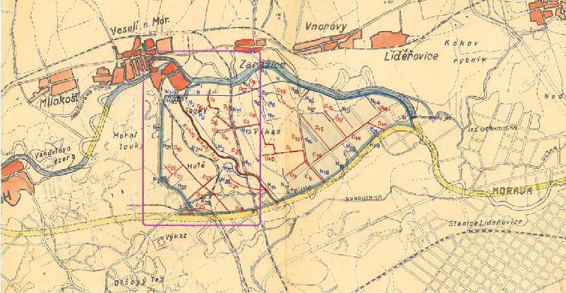
Fig. 1. Demonstration of digitised drawings of project documentation for the implementation of an irrigation system through open ditches along the Morava river in the surroundings of Veselí nad Moravou in the 1930s (areas presented in Fig. 2 are highlighted in purple, i.e. detailed investigation of the current state of the system and objects).
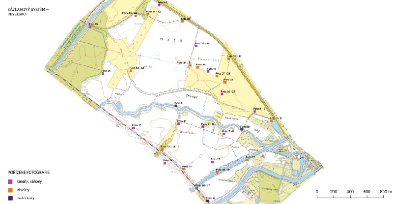
Fig. 2. Example of location processing of individual objects and selected important elements of the irrigation system in the surroundings of Veselí nad Moravou on the basis
of current field investigations, ZABAGED® data
METHODOLOGY
Generally speaking, in order to achieve the goals of similar research, it may be done via archival work, processing available analyses of input materials (especially historical documents and plans), but also current research of irrigation items and systems. Research of the chosen systems was carried out by both fieldwork with pre-prepared mapping input, and by using modern UAV technologies. The data was analysed and visualised with the help of GIS tools. The processing of all obtained input documents enabled the creation of map sets and small maps for individual territories. These documents display in detail their location and condition of preserved and extinct irrigation systems, identification of their cultural-historical value, potential for restoration and other possible uses, as well as risks resulting from their preservation and use, which concerns each area of interest.
In order to fulfil these aforementioned framework procedures, the research work was divided into three stages:
- compilation of research and archival work, processing of technical documents, overview of irrigation state,
- detailed fieldwork – record-keeping, description and visualisation of irrigation systems,
- processing and presentation of project outputs.
A practical solution according to the framework methodology was thus focused on the collection of inputs, archival investigations and processing of information, documents, and plans for irrigation structures, objects, and systems. The first stage involved the research of specialised literature which deals with the history and technological irrigation systems in the Czech Republic and neighbouring countries in the context of heritage preservation and protection of industrial heritage. In connection with the description of historical development, the typology of irrigation systems, including diagrams, was carried out. For defined areas of interest, an effort was made to gather all available materials, usually in the form of historical, technical documentation and plans, but also projects formed with the purpose of possible renewal of some segments of the system, as well as the most detailed descriptions of the original parameters of irrigation systems of interest. The materials gathered were continuously digitalised in order to secure their preservation in aggregated form, not only for future historical research and use for teaching in specialist schools, but also for informing interest groups, associations, and the wider public.
Archives for the area of the Czech Republic concerning modern irrigation systems of various typologies and generally also water management activities (under which irrigation projects falls), can be found in various location. There are archives at the central level, both domestic (National Archives of the Czech Republic in Prague, Moravian Provincial Archives in Brno, Silesian Provincial Archives in Opava) and international (especially Allgemeines Verwaltungsarchiv and Finanz- und Hofkammerarchiv in Vienna for the period up to 1918). In addition, there are regional and district archives, as well as possibly the archives of institutions and personal collections of water management specialists. The implementation of irrigation measures was undertaken at a national level by state and provincial bodies, at the regional level by regional and district authorities, and at a local level by municipalities and water organisations (cooperatives), associations, and other professional institutions.
Simultaneously, the relevant primary and secondary professional literature and published outputs were also analysed, as well as work with map data. Sources which dealt with water law, water literature, and the development of approaches to amelioration and irrigation were most often located. In addition, attention was focused on publications on water management in rural areas with a historical context. One of the most important research topics is the question of genesis, operation, and importance of so-called water cooperatives, which have been in existence since the 19th century in order to regulate water courses and conditions at a local, regional, and transregional scale. The research results were used as proof of the historical approach to solving the issue in question and also simultaneously analysed in terms of the functionality of competent powers and potential for the current period.
Irrigation issues were researched at the cartographic level. The research of cartographic maps of the time of land registry and topographical nature was undertaken in order to study cartographic depictions of irrigation systems. Their spatial dislocation and accumulative hubs was also mapped.
RESULT AND DISCUSSION
In modern terms (practically speaking from the 19th century), irrigation systems in the Czech lands have undergone huge development. The basic prerequisites enabling the implementation of modern irrigation systems in were mainly favourable legislative, finance, and expert technical conditions. Education and promotion also played an important role. The crucial legal regulation which defined water management in the western part of the Habsburg Empire was the Imperial water act of 1869. This formed the basis for more detailed legislation in the individual countries of the monarchy. These legislative documents were only part of the whole, which enabled the development of water management in the sector of regulation and amelioration. Other pillars were financial support, the establishment of an amelioration fund, and other subsidies. The final pillar was the education, propagation, and transfer of experience as well as the results of research which took place at the time. Water cooperatives became necessary tools for the development of amelioration and irrigation. The system created, with changes and modifications, was preserved and functioned well in the Czech lands practically speaking until the social changes after 1948. In 1955 a new water law was adopted, the first water management plans were assembled, water cooperatives gradually disappeared and, at the same time, the United Agricultural Unit (JZD), Machine Tractor Station (STS), and other parts of socialist agriculture were formed. At the time, the traditional irrigation of meadows was gradually abandoned and finally disappeared.
This irrigation, however, represents one of the main typological groups of irrigation with a long term history – irrigation of agricultural land with meadows with fodder for food production. The method was carried out mainly by basin irrigation using various water supply, distribution, and drainage systems. These are historically the oldest irrigation systems in Europe [1–4], some of which have survived until the present day. In many locations, work has taken place or is taking place to reconstruct the systems and to preserve and protect them as a part of cultural heritage for the future [5, 6].
Leibundgut and Kohn [3] present an overview of 116 historical irrigation systems discovered in Europe, from which the majority can be considered meadow irrigation. Geographically this applies in particular to the following countries: Germany, the former Austro-Hungarian Empire, England, Spain [7, 8], Portugal [10], France, and Italy. The implementation of meadow irrigation was not an exception even in countries where problems with a lack of water would not be expected, such as Norway, Denmark, Switzerland, Andorra, Iceland, and even Greenland [2–3].
Outside European countries, we can mention that the modern development of irrigation systems in the 19th century took place to a great extent in the United States of america. It concerned large areas of newly settled western states (e.g. [10]).
Reasons for installing meadow irrigation systems should be divided according to the altitude of the given area into the following basic zones: high mountainous landscapes, mountainous landscapes, uplands, lowlands, and hilly landscapes (hilly area). In high altitude areas, the need for irrigation was connected with the need to provide fodder and allow vegetation to regrow more quickly than would have been possible under local conditions – irrigation systems in this way allowed the soil to warm up earlier. In the lowlands, it was necessary to artificially regulate the inflow of water in different vegetation periods, meaning leading it away from the land, e.g. during summer floods, or, on the other hand, bringing in water in late spring.
A number of irrigation systems were also constructed in the Czech Republic [11, 12]. Many of them have been preserved in varying states of disrepair and damage. Nevertheless, some systems with continuously repaired selected technological structures for the distribution of water (sluice gates, culverts) further serve as part of anti-flood protection systems (typically the Morava river floodplain). Some parts of this functional complex are completely preserved and continuously maintained and serve new purposes. An iconic part of the historical multifunctional complex in the Pomoravi region is the Baťa Canal.
Within the practical parts of the research (documentation of historical meadow irrigation systems in the Czech Republic), the following areas and locations were selected on the basis of literature-based research and discussions with experts in the field and those members of the public who remember such systems:
- the Úpa and Metuje rivers basins
- the surroundings of Jevíčko and the area of Malá Haná
- the Pomoraví region from the surroundings of Chropyně through the Uherské Hradiště and Veselí nad Moravou regions to the Strážnice region.
Example identification of irrigation structures and objects in historical sources and the current landscape
The example below of the surroundings of Veselí nad Moravou presents the process of digitisation of historical project and map sources (Fig. 1), the result of the subsequent field investigation and identification of objects of the former irrigation system (Fig. 2), and the determination of their current state and purpose (Fig. 3).
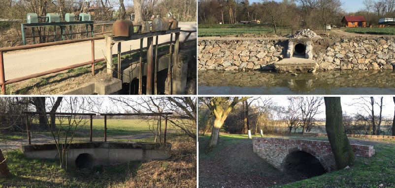
Fig. 3. Example of location processing of individual objects and selected important elements of the irrigation system in the surroundings of Veselí nad Moravou on the basis
of current field investigations (on Fig 2, these are No. 3, 23, 26, 48)
Fig. 4 is an example of information processing about the alignment and location of surface distribution identified from historical documentation. The source for the analysis of the alignment of the channel network is the Fundamental Base of Geographic Data of the Czech Republic (ZABAGED®), mapping the current state of the landscape, and preserved project documentation of water management modifications from the mid-1930s. Watercourse alignment from the second military mapping was also used for visualisation. The analysis shows that not all water distribution channels have been implemented – on Fig. 4, these are marked as “(plan?)”.
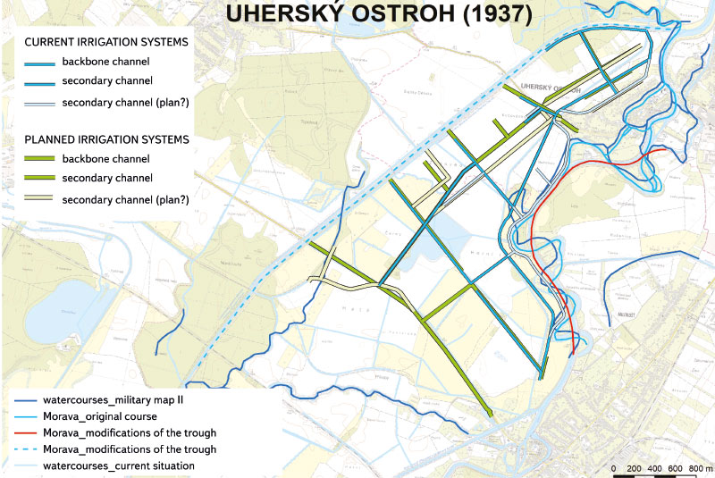
Fig. 4. Location of priority and type-related structures in the Morava river floodplain near Uherský Ostroh, ZABAGED® data
New field mapping and subsequent computer processing technologies that have been tested for documenting the heritage of historic meadow irrigation are presented in the following sub-chapters.
Possibilities of using the digital terrain model (DTM) to identify irrigation structures and objects
The fifth generation digital model of relief (DMR 5G) currently provides the most accurate representation of the relief of the entire Czech Republic. This is a dataset that was acquired as part of airborne laser scanning. It is formed by a cloud of points of known height, unevenly placed so that relief representation corresponds to reality as closely as possible. However, it should be noted that the elevation accuracy of the DMR 5G dataset is a variable dependent on terrain shape and vegetation. It ranges from a few centimetres in open terrain to decimetres in rugged forested terrain. Despite these inaccuracies, the DMR 5G dataset offers suitable possibilities for identifying specific terrain forms. Within this project, the Ratibořice site along the Úpa river was chosen for initial testing of its possible use.
Relevant map sheets were selected from the DMR 5G dataset and, in the ESRI ArcGIS 10.7 environment, they were converted into point layers and then into TIN (Triangulated Irregular Network), which is a plastic DTM. This terrain model was used to transfer the linear layers of the irrigation systems (from the Research Institute for Soil and Water Conservation application), which made it possible to search for corresponding terrain forms.
Fig. 5 shows a detail of the area near Ratibořice in the valley of the Úpa river, where irrigation system elements are demonstrably present. Comparison of the DTM, basic 1 : 10,000 maps, and aerial imagery demonstrates that the use of the DMR 5G dataset to identify irrigation system elements – or at least parts of them – is feasible and will therefore be used to the greatest extent possible during processing of all pilot sites.
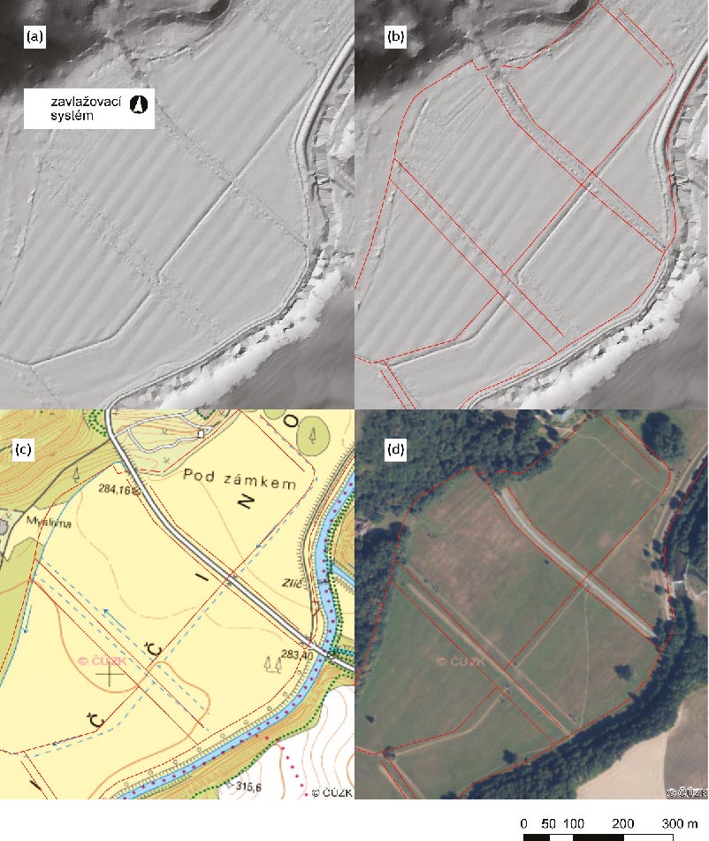
Fig. 5. Example of differentiation of the remnants of meadow irrigation by furrows and channels in the Úpa river floodplain above Česká Skalice. Demonstration of the use of the TIN DTM at the site to determine the location of the individual parts of the irrigation system: (a) TIN DTM; (b) TIN DTM, indicating the course of the irrigation system (in red); (c) extract of the basic 1 : 10,000 map, indicating the course of the irrigation system; (d) aerial image extract, indicating the course of the irrigation system ZABAGED® data.
DTMs can be used for initial analyses to identify the location of individual elements of former irrigation systems. Given the relatively limited accuracy of these data, it is advisable to use photogrammetric data taken by drone for further detailed assessment.
Detailed spatial information obtained from aerial photogrammetry (UAV) is used for subsequent 3D modelling of the virtual form of objects. The DTM is also used for this purpose.
The calculation of the DTM was carried out for selected sites of historically significant irrigation structures and systems in various location: The Břeclav, Hustopeče, Znojmo, and Hodonín regions (southern part of the Pomoraví region); near Chropyně, in the area of Malá Haná; in the Litoměřice, Poděbrady, Pardubice regions; and in eastern Bohemia in the area of Česká Skalice – in Ratibořice and in the Znojmo region (Fig. 6).
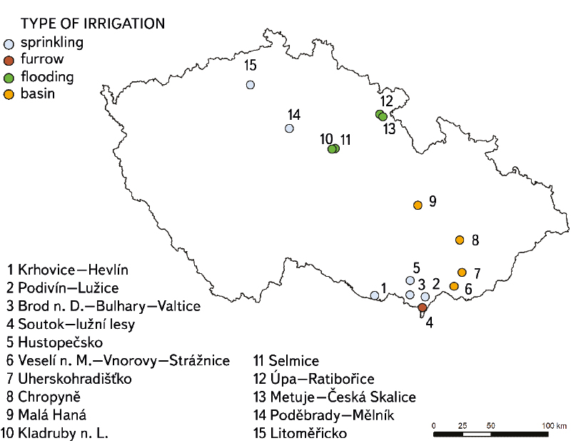
Fig. 6. DTM calculation areas for historically significant and documented irrigation sites,
with differentiated irrigation types
DMR 5G data n of the Czech Office for Surveying, Mapping and Cadastre was used for the calculation. The input text files were converted to a point layer from which the triangulated irregular network (TIN) was computed (which can be converted to a raster with arbitrary resolution).
Approaches for preserving and protecting irrigation heritage
The thematic study by Douet [13], focusing on water management as part of World Heritage, states that the water management infrastructure of the pre-industrial period is relatively well represented on the UNESCO list. This is in contrast to the cultural heritage of the so-called modern water management of the 19th and 20th centuries.
This basically also applies to the representation of historical irrigation systems. From the pre-industrial period, systems of irrigation channels that are registered as part of world cultural heritage are mainly in Middle Eastern countries (Iran, Oman, United Arab Emirates), called aflaj irrigation systems. In addition, there are irrigation systems for rice terraces in the Philippines, Bali, and China, olive trees and vines in Palestine, and ancient irrigation complexes of various types on the American continent in Mexico, and aqueduct structures that served not only to distribute water for human consumption but also for irrigation.
This monument type fully fulfils, among others, criterion (v) from the criteria for the identification of World Heritage Sites which are contained in the revised Operational Guidelines for the Implementation of the World Heritage Convention [14]. Based on the support and justification of the selection criterion (v), sites can be proposed for inclusion that are outstanding examples of traditional human settlement, land-use or sea-use, which is representative of human interaction with the environment.
In connection with a systematic approach to assessing the heritage significance (or potential) of historic irrigation systems, the approach taken by Spain could be mentioned as one of the few using an assessment methodology designed for historic water management structures. The methodology involves a range of criteria and variables that form the categories of so-called intrinsic value, cultural heritage value, and value of potential and feasibility. This methodological approach has also been used for the evaluation of historical irrigation systems [15, 16], drainage tunnels, and so-called qanats [17].
In the scope of Central Europe, Germany and Austria are countries with long-standing and extensive care for industrial heritage [18–19]. These countries are also one of the initiators who try to protect intangible cultural heritage related to traditional practices of maintenance and operation of meadow irrigation. As of 2022, a proposal was made to inscribe these practices onto the UNESCO World Heritage List.
Regarding the Czech Republic and state heritage preservation and care, represented by the National Heritage Institute, industrial objects are dealt with by the Methodological Centre of Industrial Heritage in Ostrava (MCPD), which was established as part of the National Heritage Institute for this purpose. Within their methodological activities, the MCPD issues methodological guidelines for the identification, classification, evaluation, and protection of this type of monument [20]. At the same time, it carries out continuous extensive research on individual types of technical and industrial structures in various sectors, with the aim of identifying and documenting significant monument buildings as well as typical examples of important milestones in the technological development of the water management sector. At present, some objects historically connected with irrigation can also be found among the cultural monuments of the Czech Republic. These are, in particular, Opatovice Canal and the old pumping station Paseky in Šilheřovice, near Opava. The entire former irrigation system is practically protected as part of the extensive area of Babiččino údolí (Granny’s valley) national cultural monument, in the area of the Ratibořice Chateau near Česká Skalice and the related section of the Úpa river. Unofficial industrial monuments involve the functioning Baťa Canal, among other things, as part of the water distribution system for irrigating meadows in the Pomoraví region.
CONCLUSION
Irrigation structures were built and operate mostly as part of a larger or smaller functional complex. Their significance, also from the point of view of potential heritage protection, lies in the identification and documentation not only of solitary structures but mainly of entire systems/functional complexes with descriptions of interrelationships between them. Independent objects or structures do not need to be particularly exceptional, although their involvement in a wider functional complex can create a uniquely undertaken solution. In this water management field, criteria such as typological value, value of technological flow, authenticity of form and function, value of technological and systemic links with an overlap on agriculture and industry are especially important. Historic irrigation systems can thus acquire significance from the point of view of heritage preservation, even though they usually do not contain traditionally viewed heritage values (architectural, art-historical, and others) either at all or only partially.
Acknowledgements
This paper was prepared with financial support of the DG20P02OVV015 project “Irrigation – Newly Discovered Heritage, its Documentation and Popularisation” of the NAKI II programme of the Ministry of Culture.
This paper has been peer reviewed.
