
Tools for risk assessment of catchment areas for abstraction points of water intended for human consumption
In December 2020, the new EU Directive 2020/2184 on the quality of water intended for human consumption was published. This Directive places a strong emphasis on comprehensive protection of water resources and introduces an obligation to carry out risk assessment and risk management of the catchment areas for abstraction points of water intended for human consumption, compared to the previous Directive from 1998. The risk analysis of the catchment areas must be carried out for all water abstractions for drinking purposes that abstract more than 10 m3 raw water per day. In the Czech Republic, this concerns approximately 3,650 abstractions (of which about 3,500 are groundwater abstractions and about 150 surface water abstractions). On a nationwide scale, it is therefore a considerable amount of risk analyses of parts of the catchment areas, which, according to the Directive, must be performed by 2027. The main aim of the project “Tools for risk assess-ment of catchment areas for abstraction points of water intended for human consumption” (supported by the Technology Agency of the Czech Republic) is to develop a methodology for the preparation of this risk analysis of the catchment areas. In order to ensure that the risk analyses of the catchment areas to be prepared by different entities have a uniform form and structure, a form (mock-up) of what the risk analyses of the catchment areas should look like and what they should contain has been developed within the framework of the methodology. As this is a very complex issue, only the main skeleton of the methodology will be presented in this article, focusing on the basic characteristics of the abstraction and the definition of the area (the catchment areas) in which the risk activities for the quality of the abstracted raw water are determined.
QFIELD – mobile application for data collection established on the principles of open source software
Acquisition of primary spatial data (geodata) in the form of a field survey (i.e. direct contact of the surveyor with the observed object or phenomenon of the real world) can undoubtedly be described as the most demanding method of their acquisition in terms of time and financial costs. However, in the past ten years, there has been a sharp turnaround in the field of mobile mapping. With the introduction of smartphones and laptops (tablets), countless applications for field data collection have been developed. Combined with Open Source tools, mobile data collection activities have become widely available to both professionals as well as the general public. One of these applications is QField. It is a multi-platform mobile GIS designed primarily for Google Android, Apple iOS, and Microsoft Windows platforms. Its user interface is strikingly similar to that of the QGIS desktop app, giving the false impression that the mobile app is part of it. However, it is stand-alone software developed by an Open Source solutions group, OPENGIS.ch, whose compatibility with the desktop application is ensured by another element, a plugin.
The Výrovka river basin as a suitable area for monitoring and comparing hydrological and landscape characteristics
The Výrovka river basin, as a compact area covering 542.5 km2, is very suitable for monitoring hydrological characteristics and comparing them in different landscape types. It is located on the border of the Lower Vltava and Upper and Middle Elbe sub-basins, extending in a range of 175–555 m above sea level, with a total of six landscape types according to the typology of the contemporary landscape of the Czech Republic. Simultane-ously, there is a varied mosaic in terms of geological subsoil and soil types. There have also been major changes in land use in this basin, mainly due to intensive agricultural activity and related watercourse modifications and amelioration. Monitoring activities within the project SS02030027 ”Water systems and water management in the Czech Republic in conditions of climate change” are currently taking place in the Výrovka river basin.
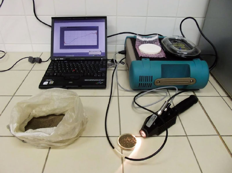
Possibilities of using spectroscopy for the evaluation of forest soil properties
The aim of this study was an objective assessment of application of VNIR spectroscopy for predicting properties of forest soils. For each soil property were found the most appropriate combination of statistical methods for pre-processing (continuum removal, 1. derivation, 2. derivation) and processing (PLSR, PCR, SVM) of certain spectral bands. As generally successful shows a combination of methods 1. derivation and support vector machine throughout the VNIR spectral range (400–2 500 nm). In some cases, however, they proved to other models. Among the best predictable features include pH, content of oxidizable carbon, aluminum, iron, silicon, or calcium (at higher concentrations). Not very high success rate prediction was found in indicators that take low values (sodium, manganese, aluminum or ferrous complexes). The results show that VNIR spectroscopy method is applicable for predicting properties of forest soils. It can not completely replace traditional analysis, but it can very well complement, especially in practice. For example, when the soil mapping can help thicken network data and refine the information better than other methods of spatial estimation. It is applicable in cases where it is required large amounts of data in a short timeframe and at minimal cost. It is suitable for monitoring trends over time, or for a quick survey of an area.

Interview with Ing. Lucie Orlíková, Ph.D., an assistant professor at the Department of Geoinformatics, Technical University of Ostrava (VSB)
Interview with Ing. Lucie Orlíková, Ph.D., an assistant professor at the Department of Geoinformatics, Technical University of Ostrava (VSB) about geoinformatics and remote sensing of the Earth.
GIS and cartography at the T. G. Masaryk Water Research Institute
Geographic information systems (GIS), data processing, evaluation and interpretation are an essential and integral part of research at present as most information can be related to a specific location on the Earth’s surface. The GIS and Cartography Department at the T. G. Masaryk Water Research Institute deals with research and commercial projects by means of the application of GIS tools.

Use of Earth remote sensing methods to monitor the condition of bathing sites
The Ministry of Health in cooperation with other related bodies compiles, on an annual basis, the List of outdoor bathing sites on surface waters where the bathing service is offered by the operator, and other surface waters used for bathing. It is compiled based on the long-term monitoring, performed, exclusively as in-situ measurements, by the regional hygiene stations. With respect to the fact that this way of monitoring is not only time-consuming but also financially demanding, the need for minimizing these expenses naturally arises.