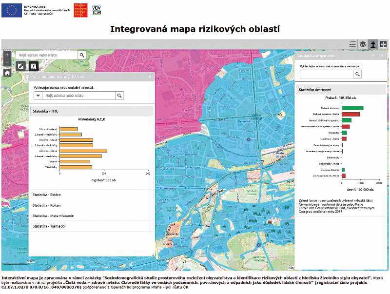
From the world of water management

Quantification of rill erosion using contactless methods

S překotným vývojem v oblasti geoinformačních a komunikačních technologií se objevují nové možnosti mapování a kvantifikace erozních procesů způsobených přívalovými srážkami. Pro získání relevantních výsledků je důležitá kvalita, hustota a rozsah vstupních dat. Rychlý a poměrně levný sběr přesných geodat umožňují bezpilotní letecké prostředky (UAV – z anglického Unmanned Aerial Vehicle). S využitím metod digitální fotogrammetrie je možné z pořízených leteckých snímků rekonstruovat morfologii terénu odpovídající času měření.

Interview with Ing. Zbyněk Folk, General Manager of The Ohře River Basin, State-Owned Company

This article is available in Czech only. For translation or more information on this topic, please contact author. Generálním ředitelem státního podniku Povodí Ohře jste se stal v květnu 2019. Po vašem nástupu do funkce v něm došlo k řadě změn. Které z nich byste označil za největší a jaké cíle si kladete do dalších let? Státní podnik Povodí Ohře… Read more »

Preservation of drinking water demand from water reservoirs in climate change conditions

This study presents interim results of an evaluation of a potential climate change impact on the preservation of drinking water demand provided by water reservoirs in the timeframe of the year 2050. Hydrological and water sources and demands balance procedures have been applied, including modelling of the storage ability of water resources and water supply systems.

Sensitivity analysis of selected input parameters of the numerical model HEC-RAS in and floodplain flow calculations

This article is available in Czech only. For translation or more information on this topic, please contact author.   Souhrn Hydraulické výpočty proudění vody v korytech vodních toků a záplavových územích se v současné inženýrské praxi provádějí primárně s použitím 1D, 2D a spřažených 1D/2D numerických modelů. Matematický model je v případě zmiňované 2D schematizace… Read more »

Monitoring of the coronavirus SARS-CoV-2 in wastewater – what the monitoring has shown us so far and where it is headed

Since April 2020, the presence of the coronavirus SARS-CoV-2 in wastewater has been monitored at TGM WRI, p.r.i. The method of detection is similar to that of clinical samples, ie the presence of a specific fragment of viral RNA is detected by PCR.

VTEI and use of unique digital identifiers

The VTEI Journal is a scientific and technical journal in the field of water management and related fields. This year, it introduced the use of two international identifiers that increase the “visibility” of published articles and their authors. These identifiers are the Digital Object Identifier (DOI) and the Open Researcher and Contributor ID (ORCID).

Using modern analytical methods for risk management and the creation of territorial strategies

Social-economic and safety risks in area are one of the main topics in these days, which in the long term affect the stability of local societies. For identification of these risks, we can use modern technology of data collection based on the analysis of illicit substances in city wastewater, as the cities are a high-risk areas from the social perspective in the Czech Republic.

Ing. Pavel Horák, CSc. died.

Dvacátého čtvrtého listopadu, na sklonku minulého roku, zemřel Ing. Pavel Horák, CSc., který pracoval v našem výzkumném ústavu na brněnské pobočce téměř čtyřicet let.

Ing. Miroslav Kněžek, CSc., died

Ing. Miroslav Kněžek, CSc., who worked at the TGM Water Research Institute, p.r.i., for almost four decades and who has contributed significantly to that the TGM WRI is respected authority in the field of hydrology and hydrogeology.

Activities of the Civic Forum of the Water Management Research Institute in 1989 and 1990

Organizační a dislokační struktura pražských složek Výzkumného ústavu vodohospodářského (VÚV) byla v roce 1989 dosti členitá. Skládal se jednak z tradičních složek vodohospodářského výzkumu, označovaného souhrnně úsek 20 se sídlem v Podbabě, experimentální skupina věnující se problematice čištění odpadních vod byla umístěna v prostorách budovy v Papírenské ulici.

INSPIRE legislative requirements for hydrological data

Směrnice INSPIRE je pojem, který se v poslední dekádě skloňuje v souvislosti s prostorově lokalizovanými daty, tzv. geodaty, hydrologickými nevyjímaje. Plným názvem Směrnice Evropského parlamentu a Rady ze dne 14. března 2007 o zřízení Infrastruktury pro prostorové informace v Evropském společenství (INSPIRE) primárně adresuje dostupnost, kvalitu, uspořádání, zpřístupnění a sdílení prostorových informací.

Workshop on Water Footprint

Dne 22. května 2019 pořádal Výzkumný ústav vodohospodářský T. G. Masaryka, v. v. i., v pražském areálu workshop na téma Water Footprint. Odborným garantem byl Ing. Libor Ansorge, Ph.D. Workshopu se zúčastnilo devět tuzemských a zahraničních expertů zabývajících se problematikou posuzování vodní stopy (WF).