ABSTRACT
In the years 2014–2019, there was a historic drought in the Czech Republic. The Department of Hydrology and Hydrogeology of the T. G. Masaryk Water Research Institute has been carrying out long-term hydrological and hydrogeological observations in the upper Metuje basin where this drought manifested itself significantly. The upper part of the catchment area of the Metuje River is located in the Police Cretaceous basin geological formation. Due to subsoil with low permeability and great thickness of Cretaceous sandstones, there is a large storage of quality groundwater, which is used for water supply to numerous municipalities and towns in Eastern Bohemia. The monitored catchment area is closed by a water gauging station on the Metuje River in the town of Teplice nad Metují (M XII). The station is located on the river in a small distance below the Skalský fault. The structure of the Skalský fault is impermeable to groundwater flow and the fault transversely intersects the whole Police basin. There are abundant springs above and at the Skalský fault and groundwater is directly recharged into the river there. Up to the profile of the water gauging station the river basin is thus hydrologically closed. This feature of the catchment area allows a relatively precise division of precipitation into evaporation, surface runoff and groundwater runoff. The Bučnice meteorological station is operated in the centre of the upper Metuje basin. Groundwater levels of deep aquifers and one shallow aquifer are measured by observation wells there. Additional water gauging stations operate on the Metuje River and on the Zdoňovský Creek.
To analyse the issue of drought, hydrological balance of the river basin was used. Available data from 1970 to 2019 were checked, specified and used as an input into the Bilan model. The input into the model consisted of series of atmospheric precipitation (P) and air temperatures (T). Parameters of the model were calibrated to match the values of series of total measured runoff (R) and modelled runoff (RM). Outputs of the model include modelled runoff from the river basin, evaporation (ET), groundwater recharge and base flow (BF). The Bilan model also calculates potential evapotranspiration (PET) and groundwater storage (GS).
Air temperature measured at the Bučnice meteorological station has a continuous upward trend over the observation period (a gradient of 0.04°C/year). In order to determine the contribution of warming to the drought of 2014–2019 and its overall impact on runoff from the basin, hydrological conditions in the basin have been modelled by the Bilan programme also for a variant without this warming.
This has resulted in determining the primary cause of the drought, namely a decrease in atmospheric precipitation by 8.6 mm/month in comparison with the average, and a corresponding decrease in runoff. In the modelled variant without long-term warming, evaporation and the decrease in runoff would both have been by 4 mm/month lower. In the overall hydrological balance, the long-term air temperature increase has a direct impact on a rise in evaporation, which results in a decline in total runoff as well as base flow. Runoff at the M XII outlet of the basin has a long-term declining trend of 2 l/s/year.
INTRODUCTION
In 2014–2019 Central Europe was hit by a historic drought. The immediate cause of the drought was repeated long-term unusual circulation conditions that prevented frontal systems to move to Central Europe. It will be possible only in retrospect to make a credible assessment about whether this change in flow is a one-off anomaly, a period within a regular cycle or the result of climate change. This paper specifies the contribution of two main causes of draught, namely lower atmospheric precipitation and increased air temperature.
The T. G. Masaryk Water Research Institute has been carrying out long-term continuous observations of climatological, hydrological and hydrogeological parameters in the upper Metuje basin. Data obtained from these observations have been used to analyse the issue of drought in the region.
Hydrogeological CONDITIONS IN the UPPER METUJE BASIN
Fig. 1 shows a schematic situation of the upper Metuje basin. The monitored area comprises the upper Metuje basin up to the location of a water gauging station marked M XII on the Southern outskirts of the town of Teplice nad Metují. This catchment area lies in the upper part of the Police basin, which is made of Cretaceous and Triassic geological formations. The Police basin is larger than the morphological area of the Metuje basin. A second significant watercourse is the Dřevíč Creek in the North-West.
Cretaceous and Triassic sediments of great thickness (exceeding 500 m in the central part) lie on the Permian-Carboniferous inner-Sudetenland (Lower-Silesian) basin. This subsoil that has low permeability and the brachysyncline (dish-shaped) placement of the basin allows accumulation of a large volume of groundwater in the Cretaceous and Triassic formation. Krásný [6] describes the upper Metuje basin up to the Skalský fault as a “Northern aquiferous system” of the Police basin with an independent groundwater circulation.
Atmospheric precipitation recharges groundwater storage in the whole area of the basin [1].
After groundwater overcomes the aerated rock environment (the aeration zone), its further flow is complicated. The permeability of individual sediment layers differs since both layers with good permeability and isolating ones have been established here. The body of the Cretaceous formation has been tectonically considerably eroded and these faults and joints can be permeable or isolating depending on the type of filling. Hynie [2] mentions a potential isolating effect in upper locations and a drainage effect in the depth even in the structure of a single fault. It may also be assumed from the brachysyncline curvature of the basin that faults near the surface are predominantly compressed and faults near the subsoil are open.
Two important individual aquifers may be designated in this varied environment, an aquifer of cuboid-shaped sandstones (D) and an aquifer of Cenomanian sandstones (A). There is an aquifer of minor importance in the Turonian layers (C) since marlite of the Lower Turonian acts as a significant isolator.
Aquifer A is located in Cenomanian sandstones that are partially covered by Turonian sediments. This aquifer is divided into aquifer A2 (chert layers) located higher and aquifer A1 situated at the base of the Cretaceous formation and connected with the Triassic subsoil aquifer (T). The A1/T lower aquifer has very good permeability and drains away most, possibly all, groundwater from aquifer A to outflows in Teplice above and at the Skalský fault (known as the Teplice outflow zone). The Skalský fault is impermeable to groundwater flow, raising its level and dividing the Police basin into two nearly separate units from the hydrogeological perspective.
A spatially varied aquifer D is located in cuboid-shaped sandstones of the Adršpach-Teplice Rocks (the Coniac-Teplice formation). This aquifer is isolated from aquifer C, which is located lower, by marlite with low permeability and groundwater thus flows away via multiple springs at erosion level of watercourses that are embedded in this marlite layer. There are numerous minor springs in the rock towns and in the North-Eastern boundary of the rocks there are four abundant springs in the Metuje River valley. The Southern rock town area is drained to the Skalní Creek and there are no abundant springs draining water to the Metuje River.
Tab. 1. Runoff composition and specific runoffs of sub-parts of the Metuje basin
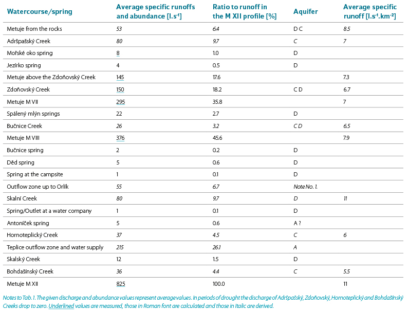
Note No. 1. The outflow section to the Metuje River from the M VIII profile up to Orlík cannot be clearly assigned to a single aquifer.
Numerous longitudinal measurements of the discharge and abundance of springs established the composition of average discharge and runoff of groundwater to the Metuje River (Tab. 1). Spatial division of groundwater recharge by precipitation may be assessed according to specific runoffs. Their comparison for sub-parts of the basin is also presented in Tab. 1.
Impact on natural hydrogeological conditions in the upper metuje basin
Groundwater storage in the Police basin and the possibility of its use for drinking water supply has been investigated since the mid-20th century. Ota Hynie carried out an extensive initial exploration, which was followed by a national enterprise Vodní zdroje where the exploration was led by geologist Vojtěch Kněžek.
Since the late 1960s, groundwater in the Teplice outflow zone of the upper Metuje basin has been used for water supply and the taken away from the catchment area. The first spring to be used was the Sokol spring, which supplied the Meziměstí municipality (approximately 1968–2003). Since the early 1990s groundwater has been drawn from deep wells (VS-5 and VS-15) in the vicinity of the Rybárna spring to supply a more extensive area connected to the Eastern-Bohemian water system. Outside the Teplice outflow zone, water is also drawn from the VS-13 well. Besides a flow deficit corresponding with the abstraction, water abstraction from the spring has not had any impact on the natural regime. Drawing of groundwater from the wells has an impact on groundwater flow and level in the basin. After the above abstractions have started, groundwater level in aquifers A1T and A2 has dropped. It may be assumed that as long as natural groundwater runoff is maintained in the Teplice outflow zone, groundwater storage is not significantly affected.
It may be presumed that natural groundwater flow conditions are also influenced by the sheer existence of numerous hydrogeological and other wells. There are dozens of fitted wells in the basin, many of which interconnect aquifers because of their inadequate technical execution. Logging measurements often confirm vertical water flows through the wells. Old wells are in a poor condition and the extent of aquifer interconnection changes over time. Deep exploratory wells were drilled in the Western boundary of the catchment area (for the sake of exploring a coal deposit) and it is not known whether they have been liquidated with a view to a potential impact on the groundwater regime.
Groundwater level in the Northern part of the Police basin could also be influenced by a decrease in groundwater level as a result of abstraction of mining water in coal mines. The Kateřina mine was located 1,200 m to the West of the Cretaceous formation boundary. Groundwork at this mine reached nearly the subsoil of Cretaceous rocks. Mining water was drawn here approximately from the early 20th century until 1993 from a great depth (460 m below sea level) in the average amount of 60 l.s-1. After the mine was flooded in 1996, mining water has been flowing away freely through an old gallery in the Jívka Creek valley. Changes in groundwater flow and level in the Cretaceous basin that would deviate from the ordinary regime and long-term flow were observed neither after water drawing was finished nor during the flooding of the mine and/or after it has been flooded. The impact of the drawing of groundwater and its termination on hydrogeological conditions in the Police basin is therefore negligible to zero in line with the assumed low permeability of the Permian-Carboniferous subsoil of the basin.
OBSERVATIONS IN the UPPER Metuje BASIN
The T. G. Masaryk Water Research Institute has been taking part in the exploration of the Police basin since 1964 and has cooperated on numerous tasks especially with the Vodní zdroje enterprise, the Czech Hydrometeorological Institute and Progeo. Most processed tasks have involved solving the balance equation of the basin and specification of its components in the upper Metuje basin, in a partial experimental Bučnice basin [3] and in the whole Police basin. Continuous data series of evaluated hydrological, hydrogeological and climatological observations regarding the upper Metuje basin have been available since 1970.
The M XII outlet of the basin on the lower outskirts of the town of Teplice is used for measuring discharge and runoff in this basin. The water gauging station is a concrete weir with a sluice, the execution of which is close to a compound measuring wasteweir. Instrumental water level measurements, discharge measurements by a hydrometric propeller and discharge evaluation have been taking place there continuously since 1970. The Metuje basin up to the M XII profile comprises an area of 74.39 km2. There are also additional water gauging stations in the Metuje basin, namely the M VIII profile on the Metuje River near Skalní mlýn where observations have been taking place since 1970 as well and a newer additional profile M VII (2017) below a confluence of the Metuje River and the Zdoňovský Creek. Observations at the Z VI outlet the of the Zdoňovský Creek have been taking place since 1996. Measurements performed by these stations specify runoff conditions of individual parts of the catchment area and they also specify and check measurements at the M XII outlet of the basin.
Groundwater level is monitored by three wells. Since 1972 water level has been measured in the VS-3 well. The water level in this well is the result of an interconnection of multiple aquifers, of which especially the A2 aquifer of chert layers has a significant impact. The A1/T basal aquifer has been monitored by the V-28 well since 1990. Conditions in the Quaternary upper aquifer have been monitored by two wells located near each other, namely V-6 (since 1970) and NS, which are evaluated jointly. Groundwater level in the Northern part of the Police basin has also been monitored by observation objects of the Czech Hydrometeorological Institute. Available data have been used to specify runoff conditions.
Basic climatological observations, measurements of atmospheric precipitation and air temperature have been taking place at the Bučnice observation station since 1970. Since 1999 an automatic meteorological station has been in operation there.
Fig. 1 presents a simplified situation of the location of the upper Metuje River catchment area in the Police basin as well as the location of the observation objects.
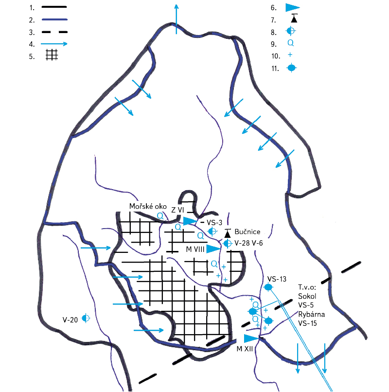
Fig. 1. Catchment area of the upper Metuje River. 1 – boundary of the Police basin, 2 – water divide line, 3 – Skalský fault, 4 – groundwater flow direction, 5 – Skály site (aquifer D), 6 – water gauging station, 7 – meteorological station, 8 – observation well, 9 – spring, 10 – outflow section, 11 – water wells, Teplice outflow zone (“T.v.o.”)
EVALUATION OF DROUGHT IN 2014–2019
In 2014–2019 the lowest measured discharge rates were recorded over the whole observation period at all observed profiles as well as the lowest groundwater levels in the wells. Several hydrometric measurements of the lowest discharges were made at the M XII outlet of the basin. Fig. 2 presents total discharge and base flow (derived from groundwater levels, see below) to the M XII profile.
Water circulation in the landscape is described by a balance equation that contains the following components for the upper Metuje basin: water enters the catchment area in the form of atmospheric precipitation plus there is inflow of groundwater from neighbouring catchment areas. Water from atmospheric precipitation leaves the catchment area naturally by evaporation and surface runoff and especially in the vegetative rest period it is absorbed in underground aquifers. A larger part of groundwater springs to the surface in the upper Metuje basin and a smaller part flows away from the catchment area. A change in groundwater storage also contributes to the balance. A part of groundwater is drained away from the catchment area for water supply purposes. There are no surface water reservoirs in the upper Metuje basin and water volume in stream beds is negligible for the long-term balance [3]. Individual components of the balance equation are specified in greater detail in separate chapters.
To address the issue of drought in the upper Metuje basin, individual components of the balance equation of the catchment area have been specified as much as possible and the Bilan hydrological model has been optimised to their values. Primary inputs into the Bilan model include atmospheric precipitation and air temperature.
Measurement of these climatological variables is more precise than hydrological data due to the nature of the measurement. Series of monthly totals/averages have been used for data processing, especially with regard to including water supply, which is available in monthly values.
Atmospheric precipitation
Data from a rain gauge at the Bučnice observation station have been used to calculate monthly precipitation totals in the Metuje basin. The rain gauge is located approximately in the centre of the upper Metuje basin on a meadow near the confluence of the Bučnice Creek and the Metuje River at a height of 490 metres above sea level. Most of the catchment area is thus located at a higher altitude than where precipitation is measured, which has been taken into account in the evaluation by increasing precipitation.
The difference between precipitation captured by a standard rain gauge at a height of 1 m and precipitation measured at ground level has been corrected in accordance with Kliner’s findings [3] by a coefficient of 1.02 for rainfall and 1.05 for snowfall.
Precipitation totals measured at the Bučnice station are very close to precipitation totals determined by the Czech Hydrometeorological Institute for the Metuje basin up to the Maršov profile at a lower altitude. Over the evaluated period of hydrological years 1970–2019, the average annual precipitation total at the Bučnice station stood at 747 mm and at Metuje up to Maršov at 751 mm (CHMI). Precipitation between 1970 and 2019 does not show a trend of a long-term change.
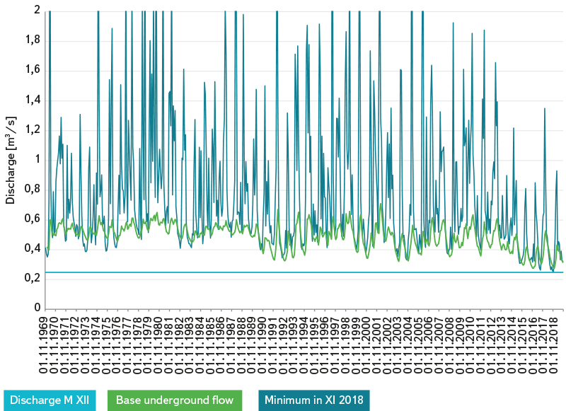
Fig. 2. Discharge and base flow in the Metuje M XII profile
Inflow of groundwater from neighbouring catchment areas and groundwater runoff away from the catchment area
The area of the Police basin sediments is larger than the morphological catchment area of the upper Metuje River. The upper catchment area of the Dřevíč Creek is also located in the Cretaceous basin. This watercourse leaves the Cretaceous below the municipality of Janovice and its catchment area in the Police basin amounts to 11.2 km2. The boundaries of the basin (Triassic) in the North are located in the catchment areas of the Zadrna River and the Scinawka (Stěnava) River. According to established groundwater levels and a hydroisopieze map put together by Uhlík [4] on the basis of these levels, groundwater flows to the central area where the Metuje river system is located due to a slanting of the sediment layers. There is also a small site (in the Zdoňovský Creek catchment area) where groundwater flows away from the basin in the Northern direction to the Zadrna catchment area. In the South of the upper Metuje basin groundwater flows away from the basin from a site to the South of the Skalský fault. A larger part of the catchment area of the Bohdašínský Creek, a left-bank tributary of the Metuje River, plus a small area on the right-bank side of the river are located there. The inflow and runoff of groundwater from areas outside the upper Metuje basin are marked in a map (Fig. 1). Assuming that the division of rainwater into evaporation, surface runoff and groundwater recharge is the same in the basin, the difference in the area where recharge and deficit occurs may be evaluated for inflow/runoff. This difference stands at 11 km2 in favour of recharge from neighbouring catchment areas.
An approximate value of groundwater runoff may be established by analysing the dependence between groundwater level and runoff at the M XII outlet of the upper Metuje basin (base flow has been separated by using the Kněžek – Kliner methodology). For this purpose, groundwater level has been compared at the end of multiple selected periods of decline in wells VS-3, V-20, V-28, V-6 and abundance of the Mořské oko spring with corresponding declines in discharge at the M XII profile. The evaluated period has been broken down into five ten-year sections in order to minimise the effect of water supply and potential long-term changes in observation well parameters. Fig. 2 presents groundwater base flow that has thus been obtained.
The inflow of groundwater via the A1T and A2 aquifers from adjacent neighbouring catchment areas increases the abundance of the Teplice outflow zone. Shallow aquifers are drained by springs in the respective catchment areas.
On the basis of the contribution of the Teplice outflow zone to the total base flow and the size of the area outside the basin from which this inflow comes, the approximate value of this inflow has been calculated from base flow. Total runoff from the catchment area has been reduced by this groundwater inflow from an area outside the upper Metuje basin.
Groundwater runoff away from the catchment area is related to the permeability issue of the Skalský fault. The Skalský fault crosses the Metuje valley in the lower part of the town of Teplice nad Metují, or rather the Skalský fault crosses there with the Police fault, which determines the river valley morphology in Teplice. Above and at the Skalský fault there is the lower part of the Teplice outflow zone, the Rybárna spring (also known as Pstruhárna, Prameniště or Jezírko) and a section of the watercourse with a direct recharge by groundwater in the bed. As knowledge is gradually obtained about this interesting site, the complicated and varied nature of hydrogeological conditions is becoming apparent, opinions are changing and starting to differ on the possibility of groundwater flow through or across the fault structure [5, 6]. The difference in groundwater level above and below the Skalský fault is approximately 40 m. Above the fault in the Teplice outflow zone piezometric water level is above the ground. Groundwater may permeate through the fault structure or overflow the fault via a Quaternary fluvial meadow. An estimate of the amount of groundwater that overcomes the fault is highly uncertain and for the sake of the balance the Skalský fault is considered impermeable. Values of the average long-term specific runoff support this assumption. Specific runoff of the Metuje River up to the M XII profile stands at 11 l.s-1.km-2 and up to the Hronov profile that closes the whole Police basin it also stands at 11 l.s-1.km-2. Specific runoff of the neighbouring Dřevíč Creek amounts to 10.4 l.s-1.km-2 (data obtained from water gauging stations of the Czech Hydrometeorological Institute).
Runoff from the catchment area
Runoff from the catchment area has been calculated according to discharge in the M XII outflow of the Metuje basin. Most water flows away from the catchment area through this gauging station due to its location below the dividing Skalský fault and at the end of the Teplice outflow zone. The impact of the short section of the watercourse above the M XII profile from the end of the Teplice outflow zone in the deficit area below the Skalský fault has been evaluated on the basis of measurements and estimated deficit of 10 l/s. The rating curve and the gauging station have been checked and it has been established that hydraulic parameters were not changed over the observation period of 1970–2019. Discharge measured by this water gauging station is checked on the basis of a discharge at a water gauging station in Maršov nad Metují that is located downstream and operated by the Czech Hydrometeorological Institute.
Water supply taken away from the catchment area
There are several groundwater users in the catchment area, the most important being Vodovody a kanalizace Náchod, a. s., which operates a system of water wells in Teplice nad Metují and takes water away from the catchment area by the Teplice–Bohuslavice water transfer. Water used by the town of Teplice nad Metují is also drained away from the upper Metuje basin. An outflow from a waste water treatment station flows into the Metuje River several hundred metres below the M XII outlet of the basin. Data from the national water management balance files regarding the Maršov profile have been used in order to calculate the amount of drawn water. The water supply has been reduced for calculation purposes by the average value of water drawn from well VS-15, 20 l.s-1. This water well lies in the Skalský fault structure and groundwater level in this well is lower than the river level without any impact [5]. A majority up to all the water drawn from this well does not belong to the assessed area of the Northern aquiferous system of the Police basin.
The total runoff input for calibrating the Bilan hydrological model has been adjusted by the amount of effected groundwater supply and groundwater exchange with the neighbouring catchment areas.
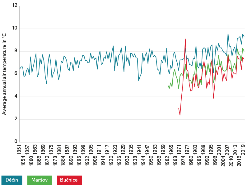
Fig. 3. Average annual air temperature
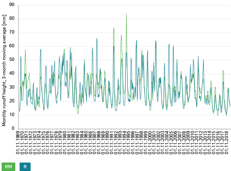
Fig. 4. Observed runoff (R) and modelled runoff (RM), 3-month moving averages
Water loss caused by evaporation
Water loss caused by evaporation, in particular evapotranspiration in the vegetation period, has been calculated by the Bilan model based on air temperature and available amount of water in the soil.
The Bučnice meteorological station measures air temperature instrumentally 2 m above the ground. The temperature shows a demonstrably increasing trend of 0.04oC/year. Fig. 3 presents the temperature over time. For the sake of comparison, temperatures in the Metuje basin up to Maršov nad Metují and a long time series in the Labe basin in Děčín are also presented.
Groundwater storage and runoff
The Bilan programme yields groundwater storage and runoff (base flow). Out of the measured data, groundwater levels in monitoring wells document the development of groundwater storage over time.
Application of the Bilan model
The Bilan model [7] uses the monthly time step to calculate chronological hydrological balance of a catchment area or of a given area. It expresses basic balance relationships on the surface of the catchment area, in the aeration zone that also includes the vegetation cover of the catchment area and in the groundwater zone. Air temperature has been used as an indicator of energy balance, which has a significant impact on hydrological balance.
Input values of the model include time series of monthly precipitation in the catchment area and series of average monthly air temperatures. When the model parameters are estimated, series of monthly runoff heights at the outlet of the basin are put in.
The calculation has provided potential evapotranspiration, actual evaporation, infiltration into the aeration zone, seepage through this zone into groundwater, water storage in snow, water storage in the soil and groundwater storage. Total runoff is modelled as a sum of three components: two components of direct runoff (that also includes hypodermic runoff) and base flow. Base flow may be identified with groundwater drainage into the river system up to the outlet of the basin.
The model has eight free parameters. To estimate them, water-measurement observation profiles use an optimisation programme that seeks parameters so as to reach a minimum value of the selected criterion for matching modelled runoff with observed data.
When the model was calibrated, there were apparent differences in data from the 1990s regarding modelled and measured runoff. An in-depth examination in accordance with Uhlík’s report [4] has established discrepancies of available water supply values. For the purposes of calibration, the section of uncertain data was omitted and hydrological years 1990–1999 were not used. Groundwater level at the beginning and at the end of the omitted section was similar.
So as to calibrate the Bilan model, atmospheric precipitation has had to be increased by a coefficient of 1.105, which takes into account the impact of the altitude of the Bučnice rain gauging station.
Fig. 4 shows observed runoff (R) from the catchment area and modelled runoff (RM). Three-month moving averages are presented for the sake of clarity.
An observation of the values of actual and modelled runoff shows differences in higher runoff values. These differences may be explained by uneven distribution of torrential rainfall across the catchment area. Inaccuracy of the measurement of water level in high water level conditions and fast changes is also apparent as well as the fact that the discharge rating curve for high discharges is derived only by a hydraulic calculation. A chart in Fig. 4 captures noticeable inaccuracies of water supply values in the 1990s. Overall, the match between measured runoff and modelled runoff has improved over time.
DETERMINING THE IMPACT OF INCREASING AIR TEMPERATURE ON RUNOFF
A calculation of runoff with adjusted air temperature has been made, using measured precipitation totals and the original model calibration parameters in order to assess the contribution of the impact of a decrease in atmospheric precipitation and an increase in air temperature. Measured air temperatures in the period of 1970–2019 have been adjusted for a zero trend of temperature increase for the purpose of this evaluation by the Bilan model.
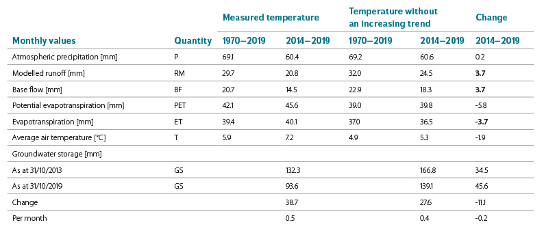
Tab. 2 presents a comparison of outputs of the Bilan model for the drought period of 2014–2019 with the whole observation period of 1970–2019 and a comparison for the model variant without an increase in temperature.
In 2014–2019 the average modelled monthly runoff (RM) was by 8.9 mm smaller than the average monthly runoff over the whole observation period of 1970–2019. This decline corresponds with the decrease in average monthly precipitation P by 8.7 mm.
In relation to average temperatures over the whole period of 1970–2019, temperatures in the drought period of 2014–2019 were above average or rather in line with the rising temperature trend.
The contribution of the long-term temperature rise to a decline in runoff as a result of an increase in evaporation is significant. If temperature had not increased, evaporation over the period of 2014–2019 would have been below average and the total difference in a loss caused by evaporation would have been by 3.7 mm/month smaller. This evaporation deficit would have manifested itself by a corresponding increase in the value of base flow (BF) and total runoff (RM).
Tab. 2. Monthly averages of hydrological balance quantities from the period of 1970–2019 and from the period of 2014–2019, in a variant of observed air temperatures and a variant of air temperatures without an increasing trend
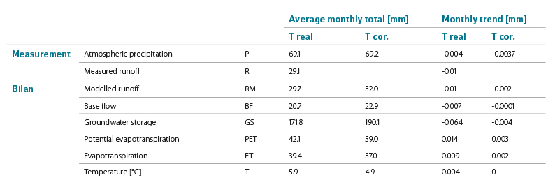
Tab. 3. Overall effect of rising air temperature
The base flow component is not very significant in decreasing groundwater storage. The overall decrease in groundwater storage over the period from the beginning of 2014 until the end of 2019 amounted to 38.7 mm. A decrease in the volume of groundwater by 2.88 mil. m3 corresponds with this decline. Tab. 3 presents a comparison of long-term balances of the upper Metuje basin over the whole observation period of 1970–2019.
Atmospheric precipitation over the whole monitored period shows a moderate decline, which is however not permanent in nature as opposed to the rising temperature. In the period of 1970–2013 before the drought started, the monthly precipitation total grew by 0.009 mm. When the observation period is evaluated by decades, it may be noted that precipitation saw a rise in three decades and a decline in two decades whereas air temperature increased in all the decades.
There is a clear impact of an increase in evaporation and a corresponding decline in runoff as a result of rising air temperature. When the trends are compared, it may be determined that runoff declines by 2.5 mm when temperature increases by 1°C.
The long-term trend of a decline in base flow as a result of a rising contribution of evaporation stands at 0.007 mm/month (if the drought of 2014–2019 and the cold year 1971 at the beginning of the observation are not included, the trend in the period of 1972–2013 stands at 0.006 mm/month). The lower value of a decline in runoff of 0.006 mm/month corresponds with a trend of a decline in discharge at the M XII profile of 2 l/s/year. The base flow value is significant with regard to water supply. Groundwater runoff was maintained in the Teplice outflow zone throughout the whole drought period of 2014–2019. The lowest measured value of abundance of the Teplice outflow zone stood at 150 l/s and the smallest calculated value was around 100 l/s. In periods of drought, the Teplice outflow zone contributes to the total base flow from the upper Metuje basin by one half. If runoff continues to decrease, problems will occur in the future with the amount of surface water. If there is a larger decline or if the natural runoff in the Teplice outflow zone ceases to exist and its function changes from a recharge to a deficit one, problems may also arise with groundwater quality in the vicinity of the water supply sites.
CONCLUSION
The primary cause of drought in the period of 2014–2019 was a decrease in average monthly atmospheric precipitation by 8.6 mm/month in the upper Metuje basin in comparison with the long-term average. The monthly average precipitation total in the period of drought stood at 60 mm/month, of which 40 mm was evaporated and 21 mm of water flew away from the catchment area or was used for water supply (1 mm of the flown-away water comes from the decreasing groundwater storage). The impact of a long-term increase in air temperature is significant. If warming had not been taking place, only 36 mm/month would have evaporated according to a model simulation and the value of the (base) monthly runoff would have been by 4 mm larger. This increase corresponds with an increase in discharge at the M XII profile by 110 l.s-1.
Warming has been manifesting itself by a decline in runoff from the catchment area long-term, not only in the extreme period of 2014–2019. Measures aimed at mitigating this unfavourable trend may lower evaporation and surface runoff in favour of groundwater recharge. This would increase base flow in the river system. Positive measures in the landscape include appropriately located ponds and deep pools that enable water accumulation and especially its seepage into groundwater. On the contrary, wetlands and shallow reservoirs in drainage areas may have a rather negative effect since they support evaporation. Measures in the landscape should therefore be expertly assessed from a hydrological and hydrogeological perspective.
