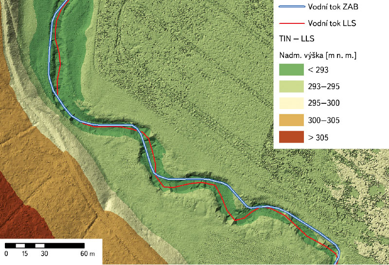
List of articles from – 1/2022

Automatic watershed delineation in the Czech Republic using ArcGIS Pro

Manual watershed delineation by watershed divides has traditionally been performed by means of an analysis of topographic maps and contour lines. With the availability of digital elevation models, watershed and streams delineation is performed automatically, which reduces the time spent on manual delineation. In this study, we introduce the process of automatic delineation and the models available within the toolbox Arc Hydro Tool Pro, created by the company ESRI for the ArcGIS Pro software. Automatic delineation was implemented by means of different methods for selected watersheds in the Czech Republic, varying in area and elevation.

Zero isochion in the framework of geomorphological regions in Czechia: its extraction from the MODIS imagery and its dynamics

Since December 2012, during every winter season, the altitude of the zero isochion (snowline) has been determined at the Czech Hydrometeorological Institute for the purposes of operational hydrology. The reason is the estimation of the amount of water stored in snow cover, which is inevitable activity for Czech hydrologists who naturally want their forecasting models to give relevant results. In order to get a better idea about current spatial distribution of snow cover in Czechia, the information on the zero isochion has been extracted from the MODIS imagery coming from the Terra satellite.

Possibilities of using spectroscopy for the evaluation of forest soil properties

The aim of this study was to objectively evaluate the applicability of VNIR spectroscopy (spectroscopy in the visible and near-infrared region of the electromagnetic spectrum) for the prediction of forest soil properties. The most appropriate combinations of statistical pre-processing (no pre-processing, continuum removal, 1st and 2nd derivative) and processing (PLSR – partial least squares regression, PCR – principal component regression, SVM – support vector machines) methods in specific spectral bands were sought for each soil property.

Practical examples of using GIS in hydrology at the Czech Hydrometeorological Institute

GIS technologies are widely used in the Hydrology Department of the Czech Hydrometeorological Institute (CHMI). The processing of geospatial data, which are used in hydrology for analytical tasks, and the development of GIS technologies in the last two decades have contributed to the spread of GIS in the CHMI practice. The use of GIS tools is shown in four examples. The first one focuses on the creation of GIS data. The second example concerns the preparation of input source data for the derivation of the hydrological characteristics of M-day discharge, which, according to Czech Standard 75 1400 Surface water hydrological data, are among the basic hydrological data. The third example describes the use of GIS in the preparation of hydrological assessments according to the above-mentioned standard (75 1400), which usually result in M-day or N-year-flood discharges in a specified profile of a certain watercourse. The fourth example focuses on the use of GIS in operational hydrological service, specifically in the development of the Flash Flood Indicator, which determines the level of risk of flash flood formation or occurrence based on current land saturation and radar rainfall estimates.

IAHS International Commission on Remote Sensing

The International Commission on Remote Sensing (ICRS), as one of the current ten scientific commissions under the umbrella of the International Association of Hydrological Sciences (IAHS; [1]), has emerged as a logical response to the availability of spatial data associated with the launch of the first satellites in the 1970s that were designed to observe the Earth’s landscape sphere from space, providing a completely new perspective in which the spatial extent of the territory under observation played the major role.

GIS and cartography at the T. G. Masaryk Water Research Institute

Geographic information systems (GIS), data processing, evaluation and interpretation are an essential and integral part of research at present as most information can be related to a specific location on the Earth’s surface. The GIS and Cartography Department at the T. G. Masaryk Water Research Institute deals with research and commercial projects by means of the application of GIS tools.