ABSTRACT
Droughts and floods are extreme hydrological phenomena that are currently increasing in frequency due to the growing impact of climate change, and can have significant effects on our lives. Within the “PERUN” research project, an assessment of drought conditions and their development in the Czech Republic is being developed, along with the innovation of the warning system by the Czech Hydrometeorological Institute (CHMI). Drought is a natural phenomenon characterized by a gradual onset, long duration, and low dynamics, which requires a specific approach. The amendment to the Water Act introduces the obligation of regular reporting on drought and the establishment of a predictive service to be conducted by CHMI. Tools are being developed for long-term prediction of water resource conditions and a methodology for drought and water scarcity management plans. These plans aim to ensure water supply, protect the environment, and minimize the economic impacts. The decision-making body for issuing measures based on the drought plans is the Drought Commission, which operates at the regional level. The warning information is available on the HAMR web portal, which also displays local threshold limits for individual water resources.
INTRODUCTION
Droughts and floods are extreme hydrological phenomena that are a natural part of our environment. However, with the increasing impacts of climate change, the frequency of these phenomena is increasing and they can significantly affect our lives. It is essential to be prepared for changes in the temporal and spatial extent of extreme hydrological events in order to minimize their negative consequences [1–4].
Drought is considered a natural phenomenon and refers to a temporary decrease in water availability. It is characterized by gradual onset, long duration, and low dynamics. It often affects large areas. Although the immediate danger of drought is minimal compared to other hydrometeorological phenomena, notifying its status and development requires a specific ongoing approach.
The one of goal of the “PERUN” research project is to create a methodology for assessing the status and development of drought in the Czech Republic and to innovate the CHMI warning system. “PERUN” is Prediction, evaluation and research of the sensitivity of selected systems, the influence of drought and climate change in the Czech Republic; it is co-financed with the support of the Technology Agency of the Czech Republic. This article includes the assessment of drought in surface water and groundwater in order to meet the requirements of an amendment to the Water Act (Act No. 544/2020 Coll.).
Until 2021, there was no official warning system that would systematically and regularly warn of the emergence and further development of drought in the Czech Republic. The amendment to the Water Act introduced the obligation to provide regular information about drought and the introduction of a prediction service. According to this amendment, CHMI must inform regions and Municipalities with Extended Powers (MEP) in a clear and comprehensible manner about the risk of the occurrence and development of drought. This will then enable effective decision-making on possible measures. For the general public, this information must be integrated with the existing phenomena, but this is somewhat complicated due to the specific nature of this specific phenomenon.
According to the amendment to the Water Act, the key research activity is currently the creation of tools for long-term prediction of the status of water resources and the subsequent interpretation of the obtained data when planning measures for managing drought and water scarcity. At the beginning of 2023, the Ministry of Agriculture (MoA) and the Ministry of the Environment (MoE) issued a joint methodology [5], which includes procedures for creating plans for dealing with drought and water scarcity, developed at the regional level. During 2023, a national plan is being created. The aim of the both the national and regional plans is to ensure sufficient water for basic needs, protect the environment from the negative effects of drought, and minimize the economic impact of drought and water scarcity. The plan contains information on the identification of water resources, drought risks, and their possible impact. The main part of the plan includes drought management procedures and water scarcity measures.
The decision-making body for issuing measures based on drought plans in the event of water scarcity is the Drought Commission. The Drought Commission meetings are already taking place at the regional level, and CHMI representatives are also participating in them [6]. Warning information is available on the HAMR information system portal [7], which also shows the local threshold limits [8].
METHODOLOGY AND MATERIAL
HAMR
The development of the HAMR system tool [9] is financed by the MoE along with other activities dealing with the impact of drought, adaptation measures, monitoring, and climate change (more at www.suchovkrajine.cz). Drought is divided into meteorological, agronomic, hydrological, and socioeconomic. From this comes the very name of the HAMR (Hydrological, Agronomic, Meteorological, and Retention) system (Fig. 1). Each component is represented by a mathematical model based on physics (SoilClim [10], Bilan [11, 12], and Wateres [13]) and is subsequently evaluated according to the calculated indicators.
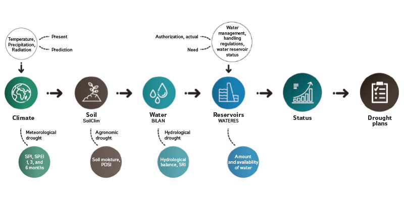
Fig. 1. HAMR system
In order to assess the current status and in particular to predict the development of drought in the Czech Republic, during 2022, a methodology was created at the CHMI, which includes predictions for three types of drought: drought in surface water; drought in groundwater; and hydrological drought (drought in both groundwater and surface water). Individual types of drought are identified for MEP territorial units [6].
Data for the warning system
135 reference discharge gauging sites (out of about 520) were selected for the evaluation of drought in surface waters according to the set criteria. The reference gauging sites were selected according to their representativeness for the relevant administrative MEP district. The aim was to select sites with a smaller catchment area, which better reflect the runoff conditions of the given MEP. Some reference sites are located in the territory of surrounding MEP, mainly due to less coverage by gauging sites with a smaller catchment area. Each MEP is assigned one reference gauging site, ideally within the given MEP. If there is no suitable site in the MEP, the most suitable site from the nearby area is selected. Some sites are thus representative of several MEP, especially in areas with a sparser river network.
Determining the risk of drought in surface waters is primarily based on the data of the reference gauging site assigned to the given MEP. However, values from surrounding reference sites and unaffected sites are also taken into account, especially in boundary situations where the flow-rate averages are close to the 355-day flow level (Q355d) for 1991–2020 [6].
Assessing the risk of drought in surface waters is primarily based on the data of the reference gauging site assigned to the given MEP. Every week, average water bearing values in the reference gauging sites for the past week and the current hydrometeorological situation are taken into account. If mean daily discharges are predicted to drop to or below the Q355d level, a surface water drought hazard is indicated for that MEP.
The resulting information on the danger of drought in the coming week in surface waters for the relevant MEP is created every Tuesday afternoon based on the synthesis of calculations and the expected hydrometeorological situation. This prediction is subsequently published on the HAMR system website in Warning information section in a separate map called „Surface waters“.
The CHMI groundwater monitoring network, which includes 874 shallow wells, 440 deep wells, and 317 springs, is used to assess the drought in groundwater. Shallow wells measure the groundwater level in Quaternary sediments with a free water level, while deep wells measure the groundwater level of underlying structures without the influence of blanket formations. Springs represent the natural outflow of groundwater.
A set of 332 features were selected for drought assessment, of which 251 are shallow wells, 75 are deep wells, and 6 are springs. When selecting the features, location within the MEP and the monitored aquifer [6] were taken into account. Most features have been monitored since 1991. Each MEP has at least one assigned object, and if no suitable object was found in its area, the closest feature monitoring the same hydrogeological structure was selected. The average weekly level in the well or the average weekly yield of the spring is decisive for the assessment of drought. If the value for at least one feature falls below the 95% quantile for the reference period, the risk of drought in the MEP groundwater is indicated. The assessment takes place every Monday and the results are published on Wednesday in the „Groundwater“ map in the HAMR system.
Local threshold limits
The local threshold limits (LTL) for water resources in order to prepare plans for managing drought and water scarcity [14] supplement the Methodology for the preparation of plans for managing drought and the state of water scarcity, which was issued by the MoA and the MoE in 2021. Planning measures for managing drought and water scarcity is the responsibility of the regional authorities according to Section 87c of the Water Act, in cooperation with the relevant basin managers and CHMI. LTLs are set for water resources that are important to a given region.
The LTL is reached when there is a high probability of insufficient yield or quality of the water resource due to drought, and at the same time there is a sufficiently long period of time before the resource will no longer be able to meet the needs of water users. LTLs are analogous to flood stages and serve to operationally implement drought management measures. LTLs can have multiple values throughout the year in accordance with the hydrological cycle and changing demands on water resources. They are derived from the moment when the resource fails to fulfil its function in relation to drought, either due to lack of water or poor quality.
LTLs complement information on the danger of drought provided by CHMI. They represent local information about the reaction of a specific water resource to an adverse hydrological situation. The methodology for drought plans describes a basic approach to determining LTL, and the handbook [14] contains examples for different types of water resources with different levels of input data detail. The aim of the handbook was to provide drought planners with possible approaches and inspiration in setting LTLs for the region‘s strategic water resources. However, it cannot take into account all the facts in the real environment, which is why individual developers of regional plans chose different strategies when determining the LTL, which are described in the plans themselves. The determination of the LTL of the water resource was to take place in cooperation with a consultation team that includes operators, water users, basin managers, regional authorities, writers of drought plans, and other relevant entities, in four steps [14]:
Selection of key quantities with systematic monitoring of water resource functioning during long-term drought.
Determination of the limit level of this quantity, which indicates exhaustion of the available amount of water in the resource or the limit for water treatment in connection with drought, at which all water requirements, including environmental requirements, cannot be ensured.
Proposal of an advance of time for reaching the LTL, which is the period between exhaustion of the available amount of water in the resource or the limit for water treatment and the achievement of the LTL.
Derivation of the level of the selected quantity that precedes exhaustion of the available amount of water in the resource or the limit for water treatment with a reasonable advance of time.
Data for local threshold limits are mostly provided by the CHMI or the operators themselves. This data is the basis for displaying the LTL in the HAMR system and is available on the system‘s website [8].
RESULTS
The resulting information (warning) on the status and development of the hydrological drought is generated every Tuesday afternoon by combining both types of drought for individual MEPs; it is visualized on a separate map in the HAMR system in the Warning Information section on Wednesday mornings. In the event that none of the mentioned types of drought is indicated for the respective MEP according to the reference profiles, these MEPs are coloured green on the resulting information map. If only one type of drought is indicated, either in groundwater or surface water, the respective MEPs are coloured yellow. If a dry period is indicated in both types of water (underground and surface), such an area is coloured orange in the resulting information map (Fig. 2). The MEP is then informed by e-mail.
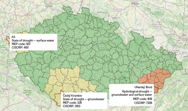
Fig. 2. Demonstration of drought prediction in the Czech Republic for Municipalities with Extended Powers [5]
As a supplement to the information system, a map (Fig. 3) was created comparing seven-day flow-rate averages in the reference gauging sites with M-daily discharges for the new reference period 1991–2020 for individual MEPs. This map serves as an indicator of the possible reaching of a drought level (Q355d) in the near future, especially if the seven-day average flow-rate is near the 330-day flow level (Q330d).
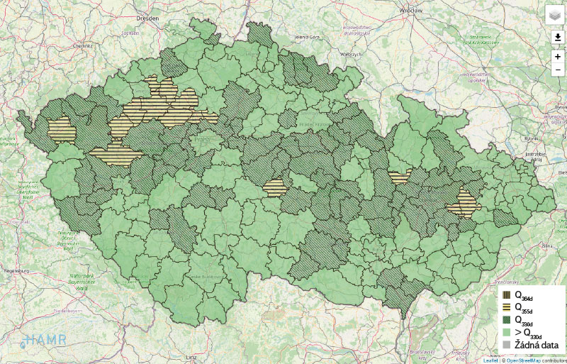
Fig. 3. Example of a complementary map of 7-day flow-rate averages in comparison to selected quantiles taken using flow duration curves of mean daily discharges, 1991–2020
At the same time, this map clearly shows where low surface water levels have dropped so much that seven-day average water levels have fallen as low as Q364d. This supplementary map is regularly created during Tuesday and published in the HAMR system on Wednesday morning at the latest, first in the Warning information section and then in the Surface waters section, where it is possible to display the average water bearing values for the previous week.
The determined local threshold limits are displayed in the HAMR application in the map window, where the current status is indicated, i.e., whether the LTLs are exceeded or not. The app displays LTLs for surface water, groundwater, and water reservoirs where LTLs are often set. Within the system, it is also possible to display time series of the selected quantities, if they are available. The LTL application was launched in September 2023 and is shown in Fig. 4.
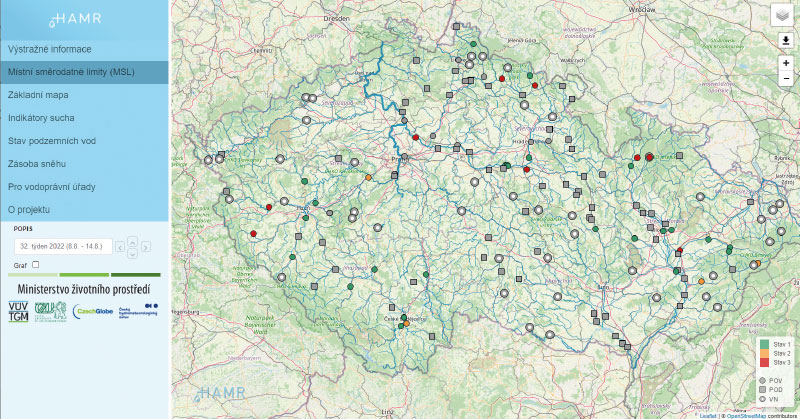
Fig. 4. Mapping application for displaying local threshold limits
CONCLUSION
Since September 2022, CHMI has been evaluating and predicting the status of hydrological drought in the Czech Republic every week. The outputs are fully available from the turn of September and October on the IS HAMR website in the Warning Information section. During the winter season 2022/2023, an evaluation took place of the test operation and verification of reference discharge gauging sites of surface water and groundwater features for individual MEP. Based on this testing, minor changes were made in the selection of representative features before the new growing season. The information system on the status and development of the drought in the Czech Republic was fully included in the CHMI operation from the beginning of the growing season in 2023. During September 2023, an application was launched in the HAMR system to display and evaluate the set local threshold limits for water resources, which are based on individual regional plans, prepared mainly in 2022.
Acknowledgements
This research was partially financed by the Technology Agency of the Czech Republic within the framework of the „Environment for Life“ programme (Programme of applied research, experimental development and innovation in the field of the environment) and the project „PERUN (SS02030040) – Prediction, evaluation and research for understanding national sensitivity and impacts of drought and climate change for Czechia (https://www.perun-klima.cz/)“.
This article was translated on basis of Czech peer-reviewed original by Environmental Translation Ltd.
