ABSTRACT
The research area of hydrogeological unit 4232 Ústecká Syncline in the Svitava river basin (Ústecká synklinála v povodí Svitavy) is an important area of underground drinking water sources. These resources are of the highest quality and among the most abundant resources in the entire Czech Republic. The development of land use is closely connected with the development of settlements and industry (textile) in the research area, which in their importance far exceeded the borders of the region. Gradual development created pressure on natural resources, especially water; the demands on the quantity of service and drinking water increased, while the quality of water was affected by industrial and agricultural pollution. Despite the observed decrease in population in the last twenty to thirty years, we can see the expansion of settlements, mainly due to new construction on agricultural land, which is slightly compensated by the expansion of permanent grasslands and forests. With regard to current and future climate change, this increase, together with a slight increase in water bodies, can be considered as a positive phenomenon.
INTRODUCTION
Monitoring the development of landscape use is an important parameter in evaluating changes in the landscape and finding answers to changes observed in many natural and social processes. Changes in the landscape are generally influenced by geological and climatic processes and the impact of human activities [1, 2]. The landscape experienced great changes during the 19th and 20th centuries, across the whole of Europe. They were mainly related to the intensification of agriculture, development of urban and suburban zones, and industrial production; but, on the other hand, also to reforestation and grassing, especially from the second half of the 20th century [3]. In recent years, land use change has been associated with addressing the impacts of climate change. From the point of view of water management, there is pressure to implement semi-natural measures and to support water retention in the landscape, protection against floods and drought, etc. [4], thanks to which the representation of grass, forest, and water areas is increasing.
In the Czech lands, changes in landscape use are closely linked to the development of society, especially population migration, industrial development of a number of settlements and regions, and the subsequent increase in agricultural production [5]. In the last 200 years, arable land was first expanded at the expense of forests and grasslands; however, with the advent of modern agrotechnical practices, this trend gradually reversed [5–7]. In recent decades, the loss of arable land has been strongly influenced by the expansion of settlements into the countryside. This also applies to the selected research area of hydrogeological unit 4232 Ústecká Syncline in the Svitava basin. In the past, this territory was strongly influenced by the development of settlements, which experienced an industrial boom associated with the textile industry, especially at the turn of the 19th and 20th centuries. This was naturally connected with a large wave of migration; even small villages were formed into important centres with hundreds to thousands of inhabitants [8, 9].
However, the development of industry, population migration, and the growth of settlements resulted in direct changes in landscape structure and in a number of natural processes; in particular, there was a great pressure on water resources. Industry in general and textile industry in particular has always been closely connected with water (powering machinery, cleaning, leaching, etc.). The negative impact on water resources was manifested in the huge consumption of water and the deterioration of its quality. Simultaneously, the demands for drinking water increased due to the increase in population. All these changes had a visible response in the landscape, where its use gradually changed; for example, the loss of arable land for new construction, planting forests for the needs of harvesting construction timber and firewood, etc.
Many standard processes and changes in landscape use can be observed within the research area, which are similar to many other places. A specific feature of the area is an important water source in Březová nad Svitavou, which does not serve to supply the local population with drinking water, but was built for the city of Brno and its surroundings more than a hundred years ago [9]. Not just with regard to the future needs of the area, it was very important to perform an analysis of the area use and to uncover the “hidden laws” of the local landscape.
METHODOLOGY
Description of research area
The research area (Fig. 1) consists of hydrogeological unit 4232 Ústecká Syncline in the Svitava basin (hereinafter referred to as the HG unit). It is located on the border of the Pardubice and South Moravian regions in the vicinity of the town of Svitavy, at an altitude between 400 (southern part) and 650 metres above sea level (eastern and western edges). The area contains significant groundwater resources; these are mainly used for drinking purposes, not only for settlements within the HG unit, but groundwater from these sources plays a significant role in the supply of the city of Brno and other towns of the South Moravian region. For this reason, in the southern part of the HG unit, there are extensive protection zones for vulnerable water resource (WPZ) in Březová nad Svitavou, where two groundwater pumping systems operate (the so-called Březovský Water Supply systems I and II).
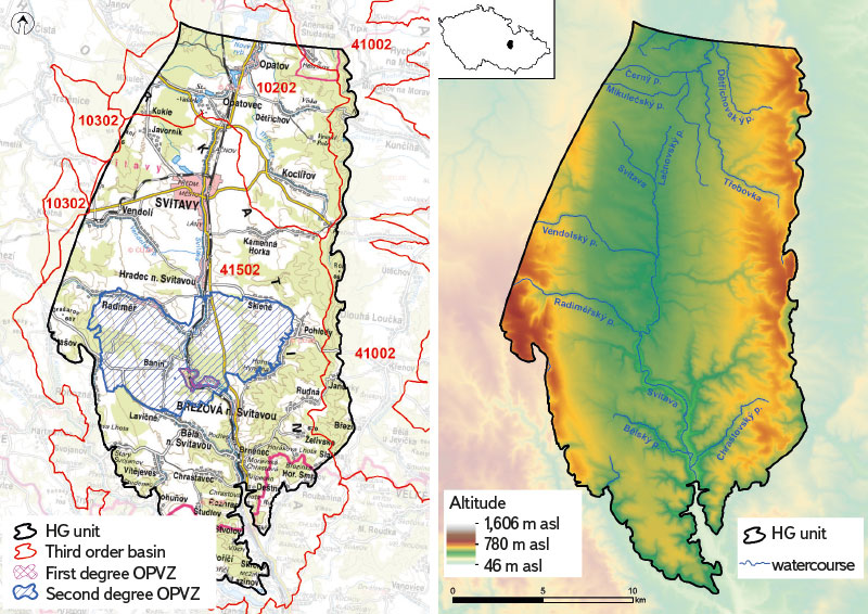
Fig. 1. Research area of hydrogeological unit 4232 Ústecká Syncline in the Svitava river basin
The HG unit area covers 358 km2 and has a north-south orientation. It represents the eastern edge of the continuous occurrence of chalk sediments in the Czech Republic, and its structure is determined by the alternation of permeable hydrogeological aquifers (sandstones) and impermeable hydrogeological insulators (claystones) [10, 11]. The stratigraphic span of the HG unit is Cenomanian and Coniacian, and several aquifers are developed here as part of the progradational cycles: basal A (Peruc–Korycany Formation, insignificant for water management), B and C aquifers (the upper part of the Bílá hora and Jizera Formations with high transmissivity and intensive ground water circulation, both used for water management) and collector D (sandy delta) [10, 12].
The backbone watercourse of the area is the river Svitava, which originates in the northern part of the HG unit (the entire HG unit is the source of water for this river). In the northern part of the HG unit, north of the town of Svitava, there is a large area which is considered to be the source area of the Svitava river. In the recent dry years, however, the watercourse up to the town of Hradec nad Svitavou has been almost without water; sometimes they talk about the “spring of the Svitava river at the Hradec nad Svitavou WWTP”, which cleans wastewater from the town of Svitavy. This also gives rise to the long-term problematic water quality in the river, especially in the section above Březová nad Svitavou. In the past, the main sources of water for the upper reaches of the Svitava were always the groundwater effluents in the area of today’s water source in Březová nad Svitavou. The Svitava has several right-bank tributaries in its upper reaches, which are mostly fed by springs from the same groundwater layers. Left-hand tributaries are not developed in the upper section; surface water flows in the valleys only during torrential rains.
Methods used and input data
The land use development analysis was created using ArcMap 10.8.1 software (©ESRI). The input data were as follows: the maps of the second (1836–1852)
and third (1876–1880) Austrian military mapping (AMM), topographic maps of Czechoslovakia (1953–1957), the Corine Land Cover database (©Copernicus Programme) for 1990–2018, and ZABAGED database (©ČÚZK) for 2023 (present).
In the first phase, land use maps were created for each period, which were then statistically analysed. Six basic categories of land use were established: built-up area (buildings and paved areas), water body (ponds and reservoirs), forest (all forest stands), permanent grassland (gardens, meadows, pastures, glades, and clearings), agricultural area (all arable land), and other (areas that could not be included in the previous categories, e.g. mining areas). Although this division does not have to correspond to the description of individual plots (e.g., in the property cadastre), it has been chosen with regard to the practical effects on the water regime of the landscape. For example, glades and clearings remain administratively forest land, although their actual function in the water regime is closer to meadows.
With the help of tools in ArcMAP 10.8.1 (©ESRI), it was possible to process and use in great detail the historical maps of Austrian military mapping (AMM) and topographical maps of Czechoslovakia for the selected research area. Nowadays, these maps are available in digital form (as WMS); however, land use maps had to be created manually (vectorization of historical maps; e.g. [13–15]).
By combining the newly created datasets with the Corine Land Cover and ZABAGED databases, a 187-year long time series of the development of land use was created in nine time sections, resulting in a unique dataset with great temporal and spatial detail. This made it possible to analyse changes in landscape use at a resolution of up to a few metres.
RESULTS AND DISCUSSION
Change in land use over the last 200 years
In general, we can say that over the years, agricultural area (40–60 %) has been most represented, which is mainly located in the central part of the HG unit; the land here is flatter with long, relatively gentle slopes (Fig. 2). The second important category is forest (30 %), or forest stands, which are most often found on the edges of the HG unit; the geomorphology here is more pronounced and unsuitable for agricultural management (Fig. 2). Permanent grassland and built-up area have a similar representation (5–10 %). Built-up area is strongly linked to the watercourses and their valleys; the settlements tend to be very long (even up to several kilometres), with an important centre of the town of Svitavy (Fig. 2). Permanent grassland are often around built-up areas because gardens and orchards are also included in this category. We also often come across grassland within the forests, which serve as clearings, glades, or cuttings during logging, allowing better movement for forest machinery (Fig. 2). There are a small number of water bodies here (maximum 0.3 %) and they are found mainly in the northern part of the HG unit, where the gentle terrain allowed the construction of ponds (Fig. 2). In the other category, mainly mining areas (stone mining) are included, essentially with a very limited occurrence in the southern part of the HG unit (Fig. 2).
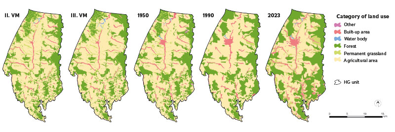
Fig. 2. Land use within hydrogeological unit 4232 Ústecká Syncline in the Svitava river basin in five different time periods – II. MM (1836–1852), III. MM (1876–1880), 1950, 1990 and 2023
Fig. 2 gives a summary of spatio-temporal changes in land use within the HG unit. There is a noticeable retreat of agricultural area in favour of forest and built-up area. Forests have seen a large increase since the mid-20th century, especially in the eastern part, where agricultural management gradually became disadvantageous due to relatively demanding natural conditions (steep terrain). In terms of settlements, the development of the town of Svitavy has been vital, mainly thanks to the industrial boom during the 20th century. In other municipalities, development is very erratic; in recent years, however, it has been associated with the boom in recreation and residential facilities for the town of Svitavy.
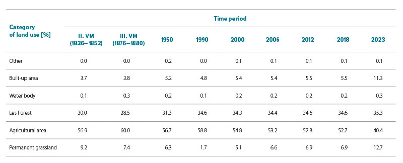
Development of the ratio of the individual land use categories is clearly visible in Fig. 3. The dominant share of arable land, over 50 % of the area, has been changing rapidly only in recent years; a large part of arable land is occupied by built-up area (increasing settlements mainly due to industrial zones) and permanent grassland, such as grassing valleys as, for example, anti-erosion and anti-flood measures. The relatively most stable category is forest, representing around 30 %; we can see a greater change in the second half of the 20th century, when afforestation took place at the expense of permanent grassland. The seemingly insignificant development of the categories other and water body can be better explained using Tab. 1. For the other category, we can see a clear increase in the 1950s (the development of mining due to the great need for building materials). The development of the representation of water bodies is interesting; in the second half of the 19th century, there was the development of small water reservoirs (ponds, water supply for industry), followed by a sharp decline at the end of the 20th century (often associated with the end of industrial activity). In the last 20 years, there has been a gradual growth due to recreation and an increase in the landscape retention capacity due to the drought intensification. The observed development trends in the monitored period correspond to changes across the Czech Republic [2, 7].
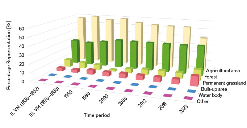
Fig. 3. Diagram of the development of individual categories of land use within hydrogeological unit 4232 Ústecká Syncline in the Svitava river basin from
mid-19th century to the present
Tab. 1. Development of the share of individual categories of land use within hydrogeological unit 4232 Ústecká Syncline in the Svitava river basin from mid-19th century to the present
Impact on water resources
Changes in land use can have a strong impact on the state of natural resources, which are essential not only for human society. With regard to the research area, where an important source of drinking water is located within the Czech Republic, there is awareness of the possible impact of changes in the use of the landscape on local groundwater resources. The area is completely dependent on groundwater, as there are no major reservoirs or watercourses. On the other hand, the area represents a source area (e.g., The Svitava river) and all water flows from there. The favourable hydrogeological conditions here have enabled the creation of a number of natural groundwater exploitations. Among the most important sources in the area were the so-called Hladové, Petrovy and Sulkovy springs (Fig. 4), which today are tapped by both Březovský Water Supply systems, supplying water to the city of Brno [9, 16]. There are many other resources intended for local use in the area. A significant customer of groundwater is the Svitavy Group Waterworks (SGW; Skupinový vodovod Svitavy), which supplies the town of Svitavy and other municipalities in the vicinity. The location of the water sources is shown in Fig. 4. The spatial distribution is more or less uniform; however, natural springs are located mainly in the marginal areas of the area and in the southern part, where the terrain and hydrogeological conditions are more favourable.
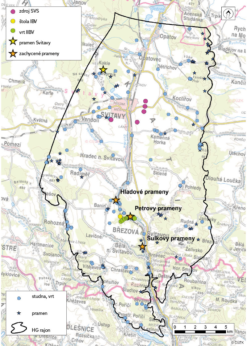
Fig. 4. Sources of groundwater within hydrogeological unit 4232 Ústecká Syncline in the Svitava river basin (SVS – Skupinový vodovod Svitavy, IBV – Březovský Water Supply system I, IIBV – Březovský Water Supply system II)
There are also a number of smaller reservoirs in the area, which were built as a result of the development and modernization of human settlements. Due to the elevation of the terrain, these water reservoirs are mainly underground, located on the plateau above the settlement (Fig. 5). Their construction is closely connected with the development of settlements in the 20th century, when a number of municipal water supply systems were established [17]. The construction of an underground water reservoir not only represents a new visual element in the landscape, but also, together with its protection area, converts mostly originally arable land into built-up area with grassland.
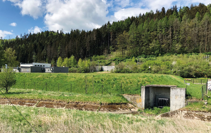
Fig. 5. An example of a ground water reservoir near the town of Březová nad Svitavou (Photo: A. Létal, May 5, 2020)
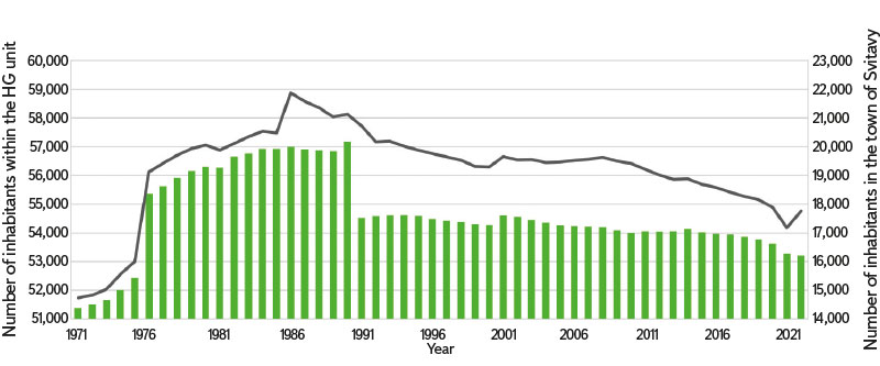
Fig. 6. Development of the number of inhabitants within hydrogeological unit 4232 Ústecká Syncline in the Svitava river basin, 1971–2022 (Source: Czech Statistical Office)
Since the 19th century, the impact of changes in land use on water resources in the HG unit Ústecká Syncline in the Svitava river basin has been closely linked with the development of settlements, which had an impact on the entire structure of the landscape. As in many other places in the Svitava river basin, there was also the development of industry that used the local water resources. For example, the village of Radiměř had a unique system of up to 17 water mills operating from the 18th century, which were, among other things, used as fulling mills [8]. The centre of industry is the town of Svitavy, which has been an important settlement since the 16th century thanks to its location at the crossroads of trade routes. The town experienced great development from the second half of the 19th century thanks to the construction of the railway (1849). More than 100 textile factories were established in the town. Gradually, the structure of the industry changed; however, the importance of the town remained unchanged. The great development of Svitavy followed in the period after World War II. It was first affected by the displacement of the large German population and the subsequent influx of new residents from all over Czechoslovakia [18]. The town development can also be seen in Fig. 2. The textile industry and the increase in population had a great influence on the local water resources, especially during the 20th century. Since the end of the 20th century, this trend has stagnated or decreased as a result of the gradual decline of the population since the 1990s (Fig. 6), the general reduction of water consumption and, above all, the end of the activities of many large industrial enterprises in Svitavy, which also had a great impact on water quality in the Svitava river itself, see [9].
A specific feature of the entire area is the water source in Březová nad Svitavou, which has already been mentioned several times. It drains a relatively large part of the local groundwater supply to Brno (about 60 km away) and other settlements. It was built in two phases (1911–1913 and 1970–1975) for the needs of a rapidly growing city [9, 16]. The influence of this water source was evident in the Svitava river, where the flow decreased significantly while the water quality deteriorated, which was caused by the lower flows and, at the same time, intensive industrial activity in Svitavy [19]. The water source itself also had an effect on the local use of the landscape; the residents were resettled and the village of Muzlov was demolished, including the subsequent afforestation or grassing of the entire first degree water protection zone [9].
In recent decades, there has been a growth of the landscape phenomenon of increasing the number of areas with permanent grassland, small water reservoirs, wetlands, etc. This trend is linked to efforts to improve the landscape’s retention capacity, strengthen its overall resilience to the negative effects of climate change, and promote its diversity with respect to ecosystem services and biodiversity [20, 21]. These changes in the landscape structure are associated with the implementation of semi-natural measures [4]. With regard to the mostly positive response to these measures in the landscape and their effectiveness (as reported by, for example, Dzuráková [22] and Beran [23]), they will be increasing, and therefore there will also be a further increase in the categories of permanent grassland, water body, and forest, mostly at the expense of agricultural areas, where these measures are most often applied.
CONCLUSION
Changes in the use of the landscape always have an effect on the natural conditions in an area, whether positive or negative. As part of the research area of hydrogeological unit 4232 Ústecká Syncline in the Svitava river basin, there have been gradual changes in the landscape composition, which are mainly conditioned here by the development of society, settlements, and industry. Despite the fact that during the last 200 years there has been an increase in the representation of forests and permanent grasslands, which could be described as a positive change, there were also negative impacts associated mainly with the development of industry (impact on the quality of surface water) and the growth of settlements, which generally exerted pressure on local water resources. A specific feature of the area is an important source of groundwater in Březová nad Svitavou, which has been draining a huge amount of water far outside the research area for more than 100 years. With regard to climate change, which also manifests itself within the research area, it is important to monitor changes in the landscape and the future development of the area and to support landscape changes with an expected positive impact, such as increasing the retention capacity of the landscape by building smaller reservoirs, wetlands, forest stands, etc.
Acknowledgements
The paper was created as part of the research project SS06010044 “Defining and evaluating areas decisive for subsidizing strategic groundwater resources with regard to their protection and stabilization” of the Environment for Life programme, financed by the Technology Agency of the Czech Republic.
This article was translated on basis of Czech peer-reviewed original by Environmental Translation Ltd.
