ABSTRACT
This article presents three typologically different sites from Polabí where large-scale wetland sites were located in the past, including ponds. These sites were chosen in order to present disappeared floodplain meadows, disappeared “field” wetlands, disappeared ponds or pond systems, and, simultaneously, to present sites where wetland habitats have been at least partially restored. The main aim was to present easily accessible archival maps, on the basis of which it is possible to assess the spatio-temporal dynamics of wetland habitats in the places of disappeared wetlands with regard to their possible restoration. The article presents the map of the 2nd military mapping as best suited for primary detection of historic wetlands. This map shows the state of the landscape in the mid-19th century rather accurately. It was, among other things, a landscape of almost unregulated watercourses, including their floodplains, as well as wetlands and springs where there is arable land nowadays. However, even the spatially less accurate map of the 1st military mapping from the second half of the 18th century provides suitable information for rough identification or detection of wetlands. Müller’s map of Bohemia from 1720, which is spatially inaccurate, can also be used as a supplement to newer documents because it shows water bodies (ponds). The information obtained can be used, for example, in landscape planning, especially with regard to the restoration and management of wetland habitats. There is an increase in landscape biodiversity at the sites restored in this way, which is in line with the EU Biodiversity Strategy for 2030.
INTRODUCTION
It is known from history that people first settled and transformed the landscape around watercourses in the lowlands. Currently, water is still perceived as a self-evident and completely normal part of life, however, despite the destructive manifestations of floods, there is a shortage of water in the current Czech landscape. Prolonged periods of drought have occurred here almost continuously since 2015. One of the main factors influencing the water regime in the landscape is agriculture. However, agricultural management is still not adapted to climate change and the result is a landscape that cannot cope with excessive rainfall and long periods of drought. Contemporary society perceives agriculture as the primary activity in the landscape, regardless of other, especially non-productive landscape functions, which are largely suppressed. In particular, agricultural management in the landscape determines the main flows of energy and substances, which are important factors for the overall functioning of landscape units [1].
At present, the area of Polabí lowland suffers from a lack of groundwater and there is a large seasonal drying of small watercourses, the vast majority of which are straightened and deepened. It is necessary to pay increased attention to the restoration of landscape features with a positive effect on the water regime in the landscape and to water management in the landscape itself. This current problem will very probably worsen in the future in connection with the expected continued occurrence of extreme climatic events.
Wetlands are one of the most significant types with a positive effect on the water regime in the landscape and water management in the landscape itself. Wetlands can also include ponds [2]. From the point of view of water management, these are one of the categories of water bodies, but from the point of view of landscape ecology, they can also be classified as wetlands. This is due to the existence of a littoral zone near the ponds and also their shallow depth. These facts meet the definition of a wetland for ponds. The main aim of the research, the results of which are presented in this article, is to assess the spatio-temporal dynamics of wetland habitats at the sites of disappeared wetlands at selected locations in Polabí with regard to their possible restoration.
STUDIED SITES
Three typologically different sites from Polabí are presented here, where there used to be large wetland areas, including ponds. All three sites are located in the sub-basin of the Upper and Middle Elbe in the Central Bohemia region [3].
Mlynařice floodplain and the disappeared Hladoměř pond near Stará Lysá
This site is located in the III order basin 1-04-07 Elbe from Výrovka to Jizera in the Stará Lysá cadastral area, and partly also in the Benátecká Vrutice cadastral area and the Lysá nad Labem cadastral area in the Nymburk district [3]. The geological subsoil consists of calcareous claystones, marlstones, and less clayey limestones [4], the predominant soil type is arenic regosol; in the Mlynařice nad Starou Lysou floodplain is it organosol [5].
Disappeared wetland near Libenice
This site is located in the III order basin 1-04-01 Elbe from Doubrava to Cidlina in the Libenice cadastral area and the Nebovidy cadastral area in the Kolín district [3]. The geological subsoil consists of claystone, siltstone, sandstone, conglomerate [4], the predominant soil type in the Libenice cadastral area is gley fluvisol, and in the Nebovidy cadastral area modal chernozem [5].
Doubrava floodplain and the disappeared Kmotrov pond near Sulovice
The disappeared Kmotrov pond is located in the III order basin 1-03-05 Doubrava in the Sulovice cadastral area. In addition, the Doubrava and Čertovka floodplains in the assessed area are also a part of th Žehušice, Horka u Žehušic, Rohozec u Žehušic, Lišice u Sulovic, and Habrkovice cadastral areas in the Kutná Hora district [3]. The geological subsoil consists of calcareous claystones, marlstones, and less clayey limestones [4], the prevailing soil types are arenic chernozem (in the vicinity of Sulovice) and arenic cambisol, and in the Doubrava floodplain, it is modal and gley fluvisol [5].
METHODOLOGY
The sites presented here were chosen in such a way as to present all the important problems and facts on which the research in the Polabí lowland was focused, i.e., to present disappeared alluvial meadows, disappeared “field” wetlands and also disappeared ponds or pond systems, and, at the same time, sites where wetlands have been restored at least partially could be presented here. The pond landscapes in Pardubice and Chlumec districts were not taken into account; they will be presented separately.
The first step was the selection and subsequent comparison of the current and historical state of disappeared wetland sites, including ponds in Polabí, based on the interpretation of map data. The next step was a field survey of these sites to verify their current condition. For the primary detection of the occurrence of wetlands, a map of the 2nd military mapping was used, which is available as a WMS service from the INSPIRE National Geoportal [6]. It is the most suitable for this purpose, as it is the first relatively spatially accurate map [7].
The current basic map of the Czech Republic 1 : 10,000 (ZM10) and the current orthophoto map of the Czech Republic were used to show the current state. Both are available as a WMS service from the ČÚZK Geoportal [8]. Subsequently, the condition of the sites recorded in the LPIs Public Land Register [9] and in the cadastre [10] was verified.
For a more accurate understanding of the development of the landscape between the state recorded on the map of the 2nd military mapping and current maps, the map of the 3rd military mapping was used, available as a WMS service from the INSPIRE National Geoportal [6], an orthophoto map of the Czech Republic from the 1950s, available within the map browser of the INSPIRE National Geoportal [11], and archival orthophoto maps available as a WMS service from the ČÚZK Geoportal [8].
To understand the state of the landscape before the 2nd military mapping, maps of the 1st military mapping and Müller’s mapping were used, which are less spatially accurate. The map of the 1st military mapping is available within the oldmaps.cz application of the Geoinformatics Laboratory of the Faculty of the Environment of the J. E. Purkyně University in Ústí nad Labem [12], while Müller’s mapping is most easily available within the map browser of the Land Surveying Office archive [13].
Current maps used
CURRENT ZM10 OF THE CZECH REPUBLIC
AND ORTHOPHOTO MAP OF THE CZECH REPUBLIC
These maps are available as a WMS service from the ČÚZK Geoportal, where they are continuously updated as needed. The displayed status on the ZM10 may differ according to the individual segments that are updated separately (e.g. road network), i.e., it may not show the real state of the landscape in a given period in all aspects. The entire orthophoto map of the Czech Republic is updated in a 2-year cycle. Approximately one half of the area of the Czech Republic is updated annually; since 2020, the borders of the regions have been taken into account during the update. Currently, both maps should correspond to the state of the landscape in 2021–2022 [8].
LPIS PUBLIC LAND REGISTRY
The LPIs consists primarily of records of agricultural land use, i.e., for determining the type of agricultural land, as well as records of landscape features, records of the location of farm buildings, and records of grass cover restoration. It shows the actual condition of the areas of agriculturally used land [9, 14].
CADASTRE
In the cadastre, it is possible to obtain selected data on plots, buildings, units (apartments or non-residential premises), and building rights registered here. In contrast to the LPIS, the entire area is captured, not just agricultural land. Since this record is not subject to automatic updating, it may happen that the recorded land type does not correspond to the actual state. This can be verified, for example, by comparing it with the current orthophoto map of the Czech Republic, which is available here as one of the maps [11].
Archival maps used
MÜLLER‘S MAPPING
The oldest map used here is Müller’s map of Bohemia from 1720 at a scale of approximately 1 : 132,000 [15]. The disadvantage for a detailed comparison of the development of the landscape with the following map documents is its unsatisfactory spatial accuracy. Therefore, it can only be meaningfully used to display water bodies (ponds) as a supplement to newer documents. Not all watercourses are shown here and the drawing is not accurate [7].
1ST MILITARY MAPPING
The basis of the 1st military mapping was Müller’s map enlarged to a scale of 1 : 28,800. The mapping itself took place between 1764 and 1768, and then between 1780 and 1783 (rectification). It captures the area of Bohemia, Moravia and Silesia as a whole in the period before the onset of the industrial revolution, at the time of the greatest flourishing of the cultural baroque landscape and its highest diversity [16]. As with Müller mapping, the disadvantage is low spatial accuracy, and therefore this map base can only be used for rough identification or detection of wetlands in a given location [7].
2ND MILITARY MAPPING
For the primary detection of the occurrence of large wetlands and water bodies (i.e., ponds), the relatively spatially accurate map of the 2nd military mapping [7] is the most suitable. It was created on a scale of 1 : 28,800 between 1836 and 1852. Its creation was preceded by military triangulation, which served as the geodetic basis of this map; it was based on maps of the Stable Cadastre (Franziszeischer Kataster), so compared to the 1st military mapping, its accuracy increased. The content of both military mapping maps is essentially the same, but the situation is significantly different. The map of the 2nd military mapping was created at the time of the onset of the industrial revolution and the development of intensive forms of agriculture, when the area of arable land increased by half in 100 years and the area of the forest reached the smallest extent in history; the first railway lines are also recorded here [17].
3RD MILITARY MAPPING
The map of the 3rd military mapping was prepared for Bohemia between 1877 and 1880 on a scale of 1 : 25,000. The reason was the fact that the 2nd military mapping was no longer sufficient to meet the army’s requirements for the maps that were accurate, and mainly up-to-date [18].
ORTHOPHOTO MAP OF THE CZECH REPUBLIC FROM THE 1950S
The historical orthophoto map includes layers of aerial photographs mainly from the years 1952–1954, supplemented by images from the years 1937–1970 and 1996, where there are no relevant photographic documents in the given period. Historical aerial photographs were provided by the Military Geographical and Hydrometeorological Office (Vojenský geografický a hydrometeorologický úřad, VGHMÚř) [19].
ARCHIVAL ORTHOPHOTO MAPS OF THE CZECH REPUBLIC
These maps are available as a WMS service from the ČÚZK Geoportal, where they are updated as needed, i.e., layers are added replacing the ones from the years that were replaced in the layer of the current orthophotomap of the Czech Republic. Each layer of the service always contains aerial photography from one calendar year on the part of the area where the aerial photography was carried out. The archival black-and-white orthophoto is displayed from 1998 to 2001, colour from 2002 to 2019 [8].
RESULTS
Mlynařice floodplain and the disappeared Hladoměř pond near Stará Lysá
In the past, in the vicinity of Stará Lysá, there was the Hladoměř pond with an area of 64 ha on the Mlynařice stream (marked as Wlkawa Bach on the map of the 2nd military mapping, i.e. Vlkavský stream), which was located in a wide floodplain formed by wet meadows and swamps with marshes. The area of the wetland site from Benátecká Vrutice to Dvorce, including the pond, was almost 150 ha.
 Fig. 1. Mlynařice floodplain and the extinct Hladoměř pond near Stará Lysá on a map of the 2nd military mapping (top) and on BM10 (bottom)
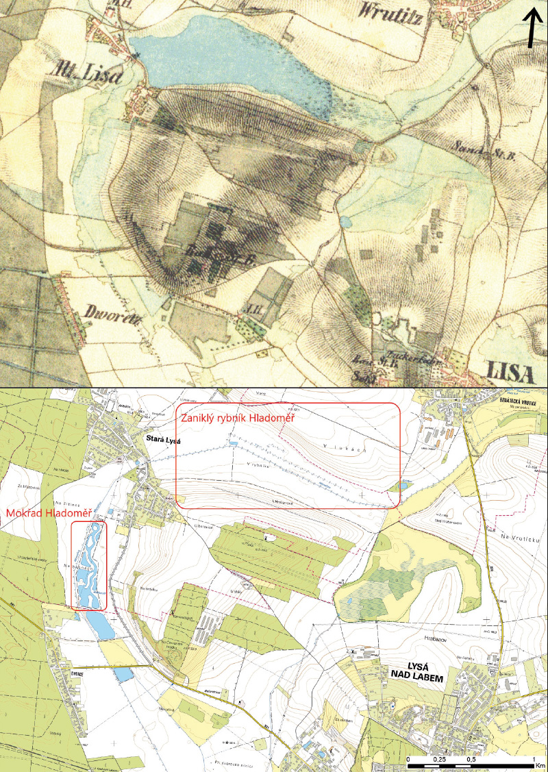
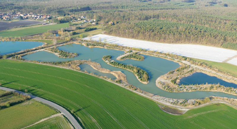
Currently, the regulated watercourse of Mlynařice flows through land made up of arable land, and at Benátecká Vrutice, it also flows through meadows. The Hladoměř pond was land-filled (Fig. 1). Between Stará Lysa and Dvorce, between 2009 and 2011, a system of several pools and a riverbed named Mokřad Hladoměř (Hladoměř Wetland) was created on the site of historical swamps and marshes. It is 700 m long and covers an area of about 10 ha. There is a sluice at the edge of the pool system, which can be used to regulate the water level. The site should attract back birds, fish and amphibians. It should be a relaxation zone for nature-watching. It cost around 20 million crowns; Stará Lysá received 18 million from EU subsidies within OPE in priority axis 6 – Improving the state of nature and landscape [20–22]. According to the entry in the land registry, this site is still on arable land, however, proceedings are being conducted here due to the discrepancy between the type of land and the actual condition. Beneath this site (behind the road to Dvorce in the Lysá nad Labem cadastral area), there is a water reservoir, which is registered as permanent grassland in the cadastre; proceedings due to discrepancy in the type of land are not conducted here. None of these sites is registered in LPIS.
Fig. 2. Mlynařice floodplain and the extinct Hladoměř pond near Stará Lysá on an orthophotomap of Czechoslovakia from the 1950s (top) and on the archival orthophotomap of the Czech Republic from 2004 (bottom)
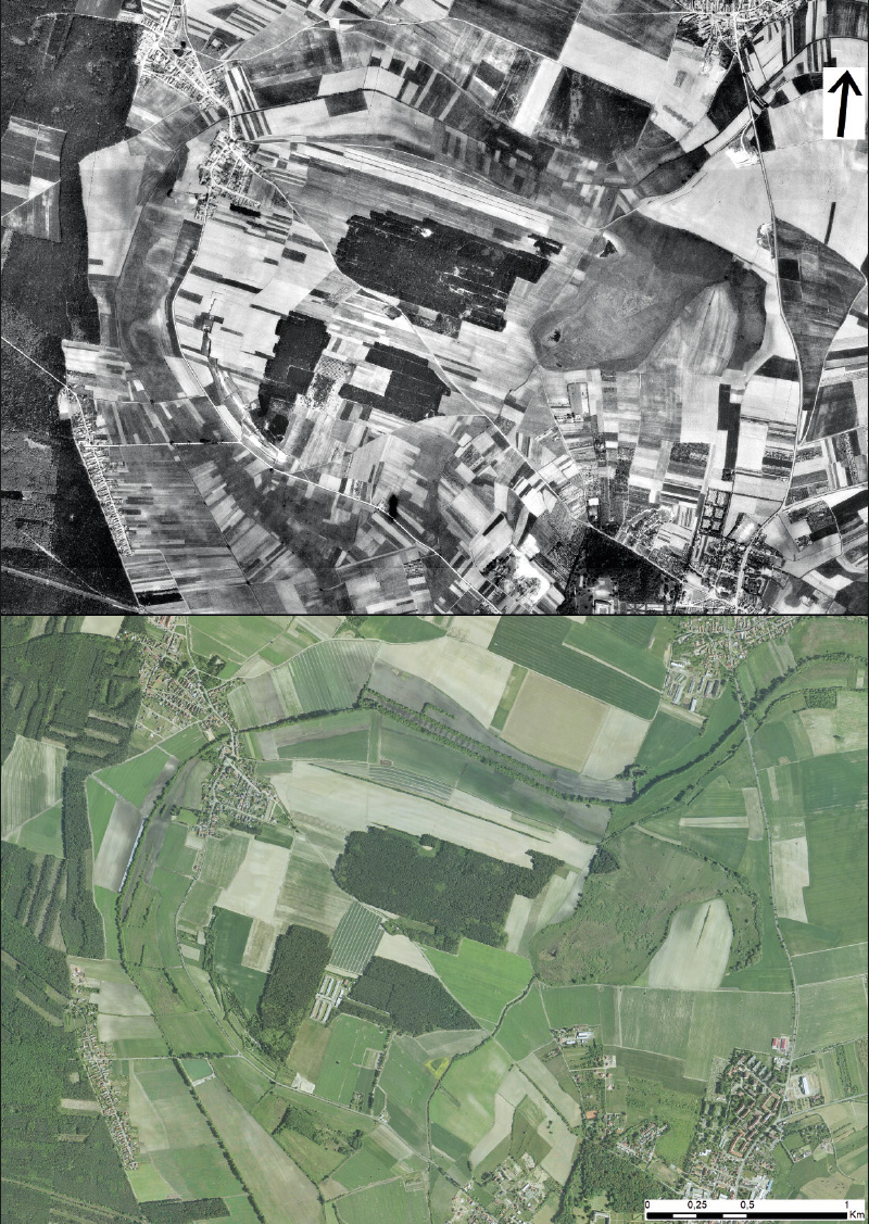
When clarifying the historical development of this site, it was found that on the map of the 3rd military mapping, the Hladoměř pond is already land-filled. In 1954, there was arable land with a classic mosaic of small plots in the Mlynařice floodplain and at the site of the Hladoměř pond. Only at the site of the Hladoměř Wetland, there was a site with wet meadows. In 2004, both sites showed signs of waterlogging (Fig. 2). In 2010, there is the Hladoměř Wetland under construction, the water reservoir under it is already built. On the current orthophoto map, waterlogged sites can be seen at the site of the disappeared pond and, to a much lesser extent, in the vicinity of the wetland (Fig. 3).
Fig. 3. Mlynařice floodplain and the extinct Hladoměř pond near Stará Lysá on the archival orthophotomap of the Czech Republic from 2010 (top) and on the current orthophotomap of the Czech Republic (bottom)
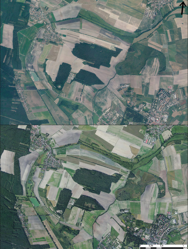
Fig. 4. Mlynařice floodplain and the extinct Hladoměř pond near Stará Lysá on the map of the 1st military mapping
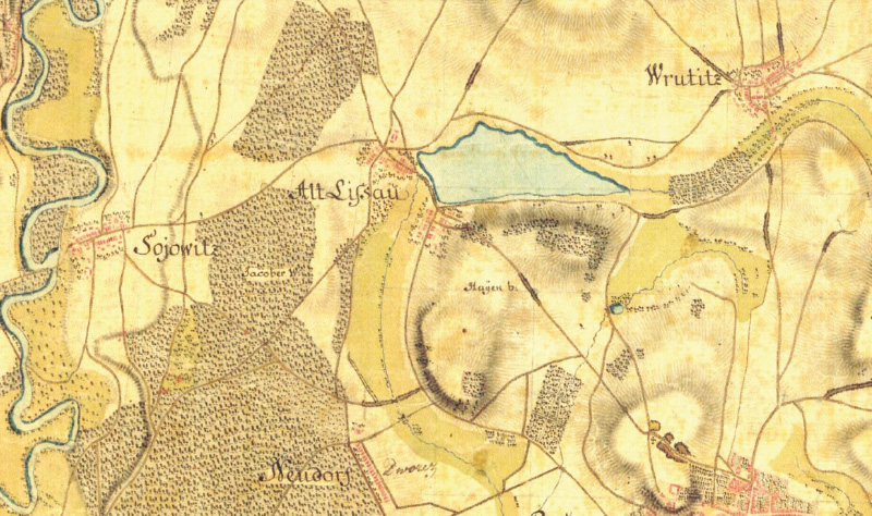
The Hladoměř pond was already recorded on the maps of the 1st military mapping (Fig. 4) and on Müller’s map of Bohemia, where, however, the Mlynařice stream is apparently incorrectly recorded (Fig. 5).
Fig. 6 and 7 show the current state of the landscape at the site of the Hladoměř pond, and Fig. 8 shows a view of the Hladoměř Wetland with already stratified bank vegetation.
Fig. 5. Mlynařice floodplain and the extinct Hladoměř pond near Stará Lysá on Müller’s map of Bohemia
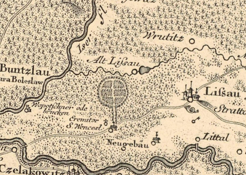
Fig. 6. Current landscape in Mlynařice floodplain at the site of the extinct Hladoměř pond near Stará Lysá, view from Benátecká Vrutice (December 2022)
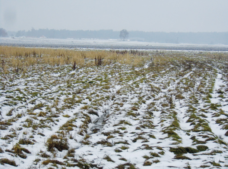
Fig. 7. Current landscape at the site of the extinct Hladoměř pond near Stará Lysá, view from Stará Lysá (December 2022)
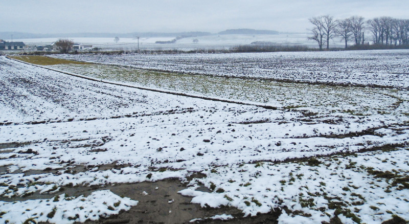
Fig. 8. Bird’s-eye view of Hladoměř Wetland (April 2020; Photo: J. Kolomazník) [22]
Disappeared wetland near Libenice
Between Šťáralka and Libenice, along the road to Kolín, there used to be a large site consisting of wet meadows with an area of almost 100 ha. It reached almost to the railway line to Kolín, beyond which there was a wide waterlogged floodplain of the Elbe. Currently, there is mainly arable land here. The bed of the Elbe was straightened due to its navigation and several water bodies were created in its floodplain. In the part of the “U Studánky” site, restoration of the area was started in 2014 named “Anti-erosion measures in the Nebovidy cadastral area – building object SO 03 – “U studánky” site, co-financed by the EU from the European Agricultural Fund for Rural Development as part of sub-measure I. 1.4. Land improvements. At the time of project approval, a subsidy of approximately 15,250,000 CZK was allocated. A system of three pools, a perimeter ditch, and vegetating the “Wetland forest” by planting trees, shrubs and grass was implemented according to the approved proposal for comprehensive land management in the Nebovidy cadastral area. The site has an area of 8.3 ha [23, 24]. It is not registered in LPIS. In the cadastre, it is registered as the land type of “other area with the greenery type of use”.
Opposite this site, located in the Libenice cadastral area, is the site “V rybníce”, where there is currently uncultivated agricultural land, an actual wetland site (Fig. 9). In LPIS, it is registered as fallow land, i.e., a temporarily intentionally uncultivated field. The site has an area of 7.5 ha. In the cadastre, the land type is arable land.
When clarifying the historical development of this site, it was found that in 1954 there was arable land on the site of the wetland site with a classic mosaic of plots smaller than at present. In 2004, there were signs of waterlogging at both sites; at the site of the future implementation of the anti-erosion project “U studánky” it is more pronounced (Fig. 10). In 2015, we can see the newly implemented anti-erosion project “U studánky” and waterlogging with successional vegetation in part of the disappeared wetland in the site “V rybníce” in the Libenice cadastral area. The current orthophoto map shows the full stratification of the newly planted vegetation in the “U studánky” site and the wetland site, registred as fallow land in the Libenice cadastral area (Fig. 11).
On the map of the 1st military mapping, this site is recorded as a meadow (wet meadow) with a spring, and partly with trees. No water body is recorded here (Fig. 12). The same situation at this site can be found also on the map of the 3rd military mapping and on Müller’s map of Bohemia.
Fig. 13 shows the current status of the implementation of the anti-erosion project in the “U studánky” site, and Fig. 14 shows the view of the “V rybníce” wetland site, registered in LPIs as fallow land.
Fig. 9. The extinct wetland near Libenice on a map of the 2nd military mapping (top) and on BM10 (bottom)
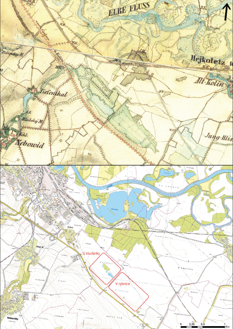
Fig. 10. The extinct wetland near Libenice on an orthophotomap of Czechoslovakia from the 1950s (top) and on the archival orthophotomap of the Czech Republic from 2004 (bottom)
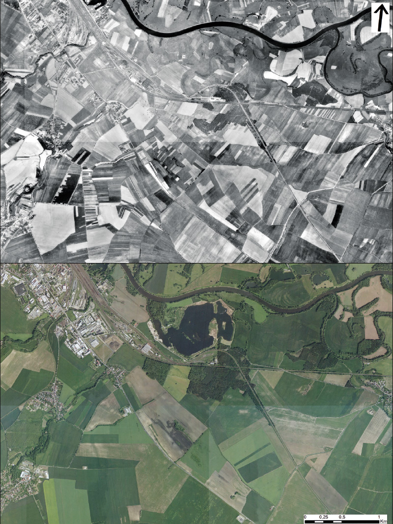
Fig. 11. The extinct wetland near Libenice on the archival orthophotomap of the Czech Republic from 2015 (top) and on the current orthophotomap of the Czech Republic (bottom)
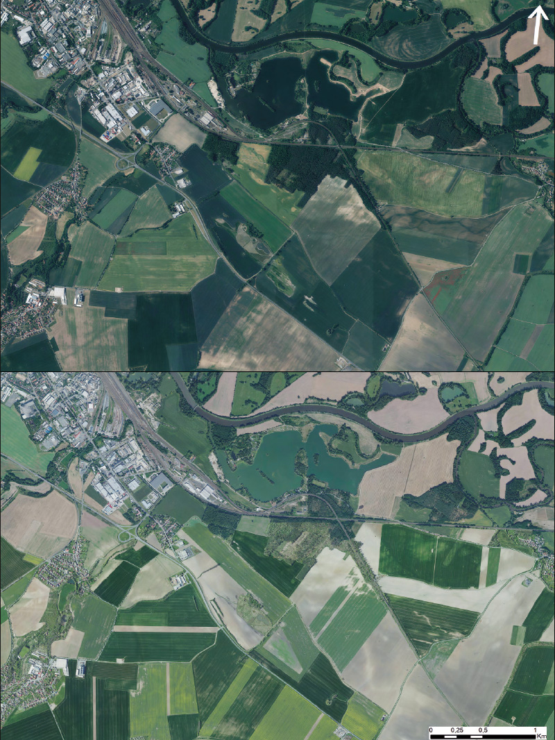
Fig. 12. The extinct wetland near Libenice on the map of the 1st military mapping
Fig. 13. Site “U Studánky” (December 2022)
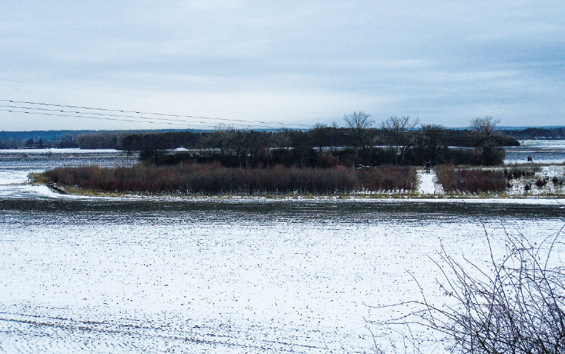
Fig. 14. Site “V rybníce” (December 2022)
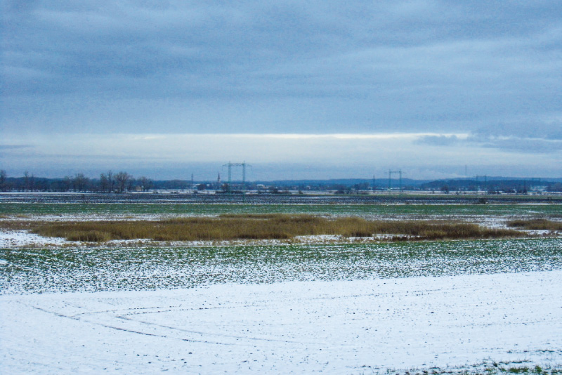
Fig. 15. Doubrava floodplain and the extinct Kmotrov pond near Sulovice on a map of the 2nd military mapping (top) and on BM10 (bottom)
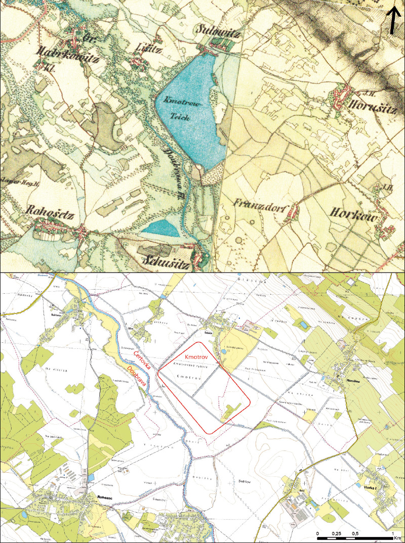
Fig. 16. Doubrava floodplain and the extinct Kmotrov pond near Sulovice
on an orthophotomap of Czechoslovakia from the 1950s (top) and on the current orthophotomap of the Czech Republic (bottom)
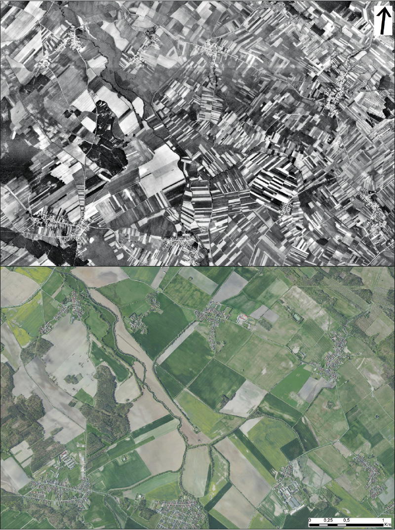
Fig. 17. Doubrava floodplain and the extinct Kmotrov pond near Sulovice on a map of the 1st military mapping
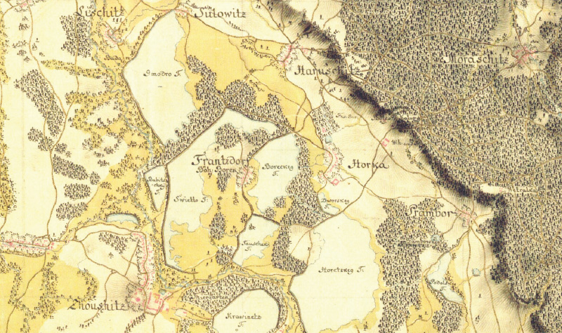
Fig. 18. Doubrava floodplain and the extinct Kmotrov pond near Sulovice on Müller’s map of Bohemia
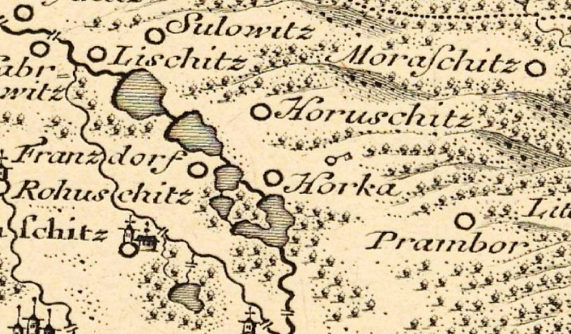
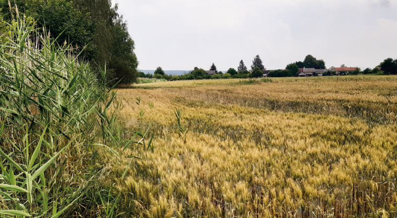
Fig. 19. The current landscape at the site of the extinct Kmotrov pond near Sulovice (July 2022)
Doubrava floodplain and the disappeared Kmotrov pond near Sulovice
Near the village of Sulovice, there used to be the Kmotrov pond with an area of 87 ha in the immediate vicinity of the Doubrava river, which was located in a wide floodplain formed by wet meadows with woody plants. Between Žehušice and Habrkovice in the neighborhood of the Kmotrov pond, wet meadows with woody plants spread over an area of over 160 ha. Currently, there is arable land, which is also in the immediate vicinity of the Doubrava river, which is bordered only by a narrow strip of riparian vegetation. Similarly to the wet meadows with woody plants in the Doubrava floodplain, the Kmotrov pond also disappeared (Fig. 15).
When clarifying the historical development of this site, it was found that on the map of the 3rd military mapping that the Kmotrov pond is already land-filled. In 1954, arable land with a classic mosaic of small plots of land was located on the site of the pond, and the Doubrava floodplain was already used as arable land. The current orthophoto map shows a change in the landscape mosaic as well as several small waterlogged areas at the site of the disappeared Kmotrov pond (Fig. 16).
In addition to the Kmotrov pond and a smaller pond near Žehušice (similarly to the 2nd military mapping), another 4 ponds are shown on the map of the 1st military mapping (Fig. 17). The same situation at this site can be found also on Müller’s map of Bohemia, although the Kmotrov pond is drawn further from Sulovice (Fig. 18).
DISCUSSION AND CONCLUSION
It has been known for a long time that it is advisable to look for inspiration in old maps for landscape planning. These can be used as a basis for the restoration of springs, ponds, wetlands or alleys [25].
Due to the different times, the technical aids used, the way of recording the state of the landscape, the circumstances of the creation of the maps used here, as well as due to the different interpretation of the landscape cover, or wetland habitats on these maps, the results of landscape development presented here cannot be taken completely uncritically. However, the basic landscape changes and the trends of these changes are evident from the individual maps at the sites presented here. It involved the gradual drainage of the landscape by the elimination or significant reduction of water-retaining elements such as wetland habitats, including ponds and other types of vegetation such as meadows and woody plants, especially in the floodplains of watercourses.
The map of the 2nd military mapping was chosen as the initial historical map source. It is a map that is most suitable for the primary detection of the occurrence of wetlands, relatively spatially accurate, with an available understandable legend. This map is the most suitable for the identification of historical large wetlands, or meadows in floodplains, and ponds. It is based on the same concept as the more detailed maps of the Stable Cadastre (Franziszeischer Kataster) cadastre; in terms of landscape development in the studied sites, there have been no significant changes, with the exception of the first railway lines. For this type of analysis in this type of landscape, maps of the Stable Cadastre (Franziszeischer Kataster) cadastre do not offer any significant advantage. Other archival maps, both of older and more recent date, were used as supplements to verify the temporal stability of historical wetlands, especially ponds.
In the evaluated site near Stará Lysá, there is a long-established wetland site of the source of the nameless Mlynařice tributary. It is found on all maps, except for Müller’s mapping, which is, however, the least reliable and on the smallest scale of all the maps used. On the edge of this spring there was a small water reservoir (pond), which was drawn on all three maps of military mapping, but is no longer shown on newer documents. The main topic of this article is disappeared wetland sites, therefore this stable landscape feature is only mentioned in the discussion. On Müller’s mapping, the watercourse of Mlynařice is apparently wrongly drawn as a tributary of the Jizera, not the Elbe, but this does not in any way reduce the credibility of the drawing of the Hladoměř near Stará Lysá pond on this map.
In the evaluated site near Libenice, there are currently two wetland sites instead of one large one: “V rybníce” in the Libenice cadastral area, and “U studánky” in the Nebovidy cadastral area. While at the “V rybníce” site it was not possible to identify at least a hint of the presence of a water body on any of the maps used, at the “U studánky” site a spring is visible on the map of the 1st military mapping. Similar to the two previous military mappings, only the site “U studánky” is recorded on map the 3rd military mapping. In addition to the watercourse, only arable land is recorded at the “V rybníce” site on map the 3rd military mapping. However, the significant transformation of the landscape from the one recorded on the first two military mappings, the large changes recorded on the orthophoto map from the 1950s, and up to the present day, is clearly visible.
In the assessed site near Sulovice, the disappearance of the Kmotrov pond was recorded from the 3rd military mapping. In addition to the Kmotrov pond, four other ponds were recorded on Čertovka on the map of the 1st military mapping and Müller’s mapping (unlike the 2nd military mapping). It was therefore a pond system on Čertovka, which is recorded on the two oldest maps used as a channel feeding this pond system from the river Doubrava and then returning back. However, on Müller’s mapping the Čertovka is recorded as the main stream, while on the map of the 1st military mapping it is the Doubrava. It is possible that at the time of Müller’s mapping, Čertovka could have appeared to be carrying more water due to the supply of the pond system, or it is an erroneous drawing, which is not unusual with watercourses on this mapping.
At the two sites presented in this article, an example of good practice is shown, where the restoration of the landscape was carried out in places of historical occurrence of wetlands, and this confirms the fact that the most suitable places for the restoration of wetlands are their historical locations, if the character of the current landscape does not differ diametrically from the past (e.g., by building development, construction of transport infrastructure, mining). This applies mainly to agriculturally used landscapes. At Stará Lysá, it is a system of pools built on the disappeared floodplain meadows (wet meadows) in the Mlynařice floodplain. It was primarily built to increase the landscape biodiversity. Beneath this newly constructed wetland is a reservoir designed for sport fishing. At the “U pramene” site, the wetland habitat was restored on the site of an disappeared wetland, which in the past was documented on maps as a spring. There are several hunter’s chairs at this site, which shows it is also used for hunting.
The restoration of these sites involved large financial costs, mainly from EU funds. The restoration took place since 2009, or 2014, i.e., quite a long time ago. It is obvious that if there was the will to do so, it was possible to use the financing for the restoration of wetlands in the places of their historical occurrence to a much greater extent. One of the biggest obstacles for any activities of this type is, apart from political and social pressures, the ownership of the land in question, where it is necessary to obtain the consent of a large number of land owners.
Neither at the site of the disappeared Kmotrov pond nor in the Doubrava floodplain any restoration has yet taken place. If we only take into account the current state of the landscape, it would certainly be possible to build small wetlands, especially pools, on waterlogged small sites on the area of the current arable land where reeds grow. There are types of very fertile soils at the site of the disappeared pond, but if the crop sown on the waterlogged site does not grow and is replaced by reeds, it would be appropriate to use this fact to restore stable water-retaining elements in the landscape.
A problem in the restoration of wetlands, even in the places of their historical location, could be drainage structures, so-called “reclamation”. However, to determine the extent and condition of these buildings is complicated; complete documentation has not been preserved. So if there are no documents for the implementation of drainage structures in a certain area, it does not automatically mean that they have never really been implemented there. It is also impossible to determine the degree of functionality of these buildings with absolute precision. There are currently two publicly available registers of implemented drainage structures. The first concerns constructions implemented within the scope of the ZVHS (Zemědělská vodohospodářská správa, Agricultural water management) on the Farmer’s Portal (Portál farmáře) [26], the second is on the Information System of Reclamation Constructions (ISMS, within the Research Institute for Soil and Water Conservation) [27], where, in addition to the above-mentioned structures, there are also constructions implemented outside the scope of the ZVHS or after it became defunct. Neither of the registers provide completely identical data even in the case of constructions implemented within the scope of the ZVHS, however, these documents are sufficient for an idea of the extent and condition of drainage constructions implemented in the sites presented in the article. At the site of the Hladoměř Wetland and the disappeared Hladoměř pond near Stará Lysá, reclamation structures built between 1968 and 1969 are recorded on the data from the Farmer’s Portal, while the extent of drained areas is larger on the ISMS, the year of construction is 1981 and they are marked as in operation. If the data is still up-to-date, from this point of view it may seem that functional drainage structures may not be an obstacle for a certain type of landscape restoration. At the site of the disappeared wetland near Libenice, data are only available from the Farmer’s Portal; they are drainage structures from 1931, according to the state of the landscape clearly now defunct. According to the Farmer’s Portal, there are drainage structures from 1979 and 1989 on part of the disappeared pond Kmotrov near Sulovice, while according to the ISMS, the extent of drained areas is larger, the year of construction is 1982 and they are marked as not in operation; in the Doubrava floodplain, drainage structures are registered on on the left bank of the Doubrava near Rohozec from 1983 marked as in operation.
The methodology “Measures to strengthen infiltration processes in the landscape” [28] responds to the above-mentioned issue; among other things, draft solutions in the field of regulation of runoff in drainage systems and strengthening of water retention in the soil are presented, where wetlands are also considered. The solution to the current situation is also outlined in the “Measure Plan for Solving Drought through Land Modifications and Hydromelioration Adaptations in the Horizon 2030” [29]. Four types of adaptation measures are considered. First, rebuild the existing structures into so-called regulation systems, which retain water in the dry season and make it accessible to plant roots; second, remove parts of the existing systems (only where the system is defunct or should not have been established); third, supplement the drainage systems with retention reservoirs or wetlands with the possibility of further treatment of drainage water (removal of N and P, possibly pesticides) and subsequent reuse. As a last option, the total reconstruction of the system is proposed.
The results presented here could make a practically usable basis for the restoration of wetland habitats in the place of those that have disappeared, because the historical location of such features is a strong argument for their restoration. These landscape features are also a fragment of the mosaic of all solutions for adapting to the problems caused by current climate change. A living and varied landscape contributes significantly to water retention in the landscape and is a prerequisite for maintaining a more stable climate. In the case of landscape restoration in places of disappeared wetlands, there is also an increase in biodiversity, which is in line with the EU Biodiversity Strategy until 2030 [30]. This is a long-term plan to protect nature and stop the degradation of ecosystems, whose main objective is to show the way to restore biodiversity in Europe.
Acknowledgements
The article was written within the framework of the TGM WRI internal grant no. 3600.54 .03/2022 „Water in the landscape as an indicator of territory changes in the Polabí lowland“.
The Czech version of this article was peer-reviewed, the English version was translated from the Czech original by Environmental Translation Ltd.
