ABSTRACT
The article presents the pond landscape development in the Bečvárka river basin based on the interpretation of archival and current maps, including verification of the current state of pond locations. Eleven ponds with a total area of 65.28 ha were recorded on the map of the 2nd Military Mapping. Sixteen ponds with a total area of 76.64 ha were recorded on the current map. The current ponds’ total area is approximately 11 ha larger than the area of the historical ponds. This is despite the fact that almost all individual historical ponds had an area larger than at present. One of the main reasons for this is the later construction of two large ponds in the area. From a comparison of the maps, it is clear that the reduction in the areas of individual historical ponds at present is mainly caused by the overgrowth of the littoral zone.
INTRODUCTION
The main objective of the research, the results of which are presented here, was to map the landscape development in the locations of disappeared ponds in the catchments of the Labe tributaries in the Polabian Lowland based on the interpretation of archival maps, especially with regard to the possible restoration of water retention elements in this landscape. Here, the development of the pond system on the Bečvárka river, or rather in the basin of the Bečvárka water body, is specifically described. The Polabian Lowland currently suffers from a lack of groundwater and there is a large-scale seasonal drying up of small watercourses, mostly straightened and deepened. These phenomena are probably going to reoccur in the future and the associated issues will be accentuated in connection with the expected continued occurrence of extreme climatic events. It is therefore necessary to focus attention and efforts on the restoration of landscape elements with a positive impact on the water regime and, in particular, on water management in the landscape.
SITE DESCRIPTION
Hydrology and administrative division
This pond system is located in surface water body HSL_1630 Bečvárka (Miletínský stream) from the source to the mouth of the Výrovka watercourse. This water body is part of the third order catchment area 1-04-06 Výrovka, which is located in the Elbe catchment area at the watershed of the Upper and Middle Elbe and Lower Vltava sub-catchments. The Bečvárka river originates near Miletín at 440 m above sea level; its length is 22.9 km and as a right-bank tributary it flows into the Výrovka river at river km 23.2 in the Zalešany-Žabonosy-Plaňany area at an altitude of 219 m. According to the Strahler order of watercourses, the Bečvárka river is in the fourth order at the confluence with the Výrovka river. The basin of the Bečvárka water body (Miletínský stream) from the source to the mouth of the Výrovka river consists of seven fourth order basins (HLGP) with a total area of 64.3 km2 [1, 2]. From an administrative point of view, the water body is located in the Central Bohemian Region, partly in the districts of Kutná Hora (cadastral area Jindice and Solopysky) and Kolín (cadastral area Bečváry, Bošice u Kouřimi, Červený Hrádek u Bečvár, Horní Chvatliny, Mlékovice, Poďousy, Přebozy, Svojšice u Kouřimi, Zásmuky, and Žabonosy). Its catchment area covers seven cadastral areas in the Kutná Hora district and 24 cadastral areas in the Kolín district (Fig. 1). From the perspective of drought in the landscape, all cadastral areas in the catchment area are among those at risk of drought, with the exception of cadastral areas in the source areas of the Bečvárka and Miletínský stream (Fig. 2) [1].
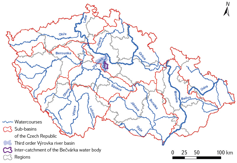
Fig. 1. The researched area in a hydrological and administrative context
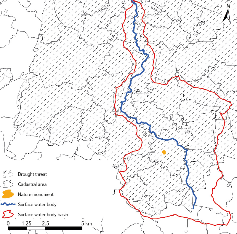
Fig. 2. The Bečvárka water body basin from the perspective of drought issues in the context of nature protection
Geology, pedology and erosion risk
Geologically, the entire Bečvárka basin is part of the Bohemian Massif. The geological bedrock consists mainly of paragneisses and migmatites of the Kutná Hora Crystalline. Gravels, sands, conglomerates, and sandstones occur in places in the upper and middle parts of the basin. Marls, calcareous claystones and more basic metamorphic rocks (amphibolites and serpentinites) also occur in the middle and lower parts [3].
Soil conditions throughout the basin are heterogeneous, with eight soil types (Tab. 1). In the immediate vicinity of watercourses, these are primarily gleys (with a pronounced reductomorphic diagnostic gley horizon as a result of long-term wetting by high groundwater levels) and also fluvial soils (with fluvial diagnostic features resulting from periodic sediment deposition and the occurrence of new formations resulting from water infiltration during flooding).
Tab. 1. Representation of soil types in the Bečvárka water body basin
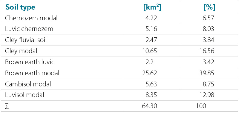
In the wider area of the basin, brown earths (soils with a profile differentiated into a slightly pronounced eluvial horizon, transitioning without tongue-shaped inlets into a homogeneously brown luvic horizon) and luvisols (soils with the presence of a luvic horizon with dark argillaceous materials, located locally on the periphery of the extension of chernozems from loess) predominate; also, cambisols (soils that form mainly in sloping conditions, only to a lesser extent in flat relief) and chernozems (deep humus soils developed from carbonate sediments) [4, 2].
In connection with the area’s diversity, it is also possible to observe different levels of vulnerability of farmed soils to water erosion [5]. In addition to the characteristics of the relief, this is the result of the creation of large plots of land without anti-erosion measures and the cultivation of wide-row crops on slopes. Especially in the upper areas of watercourses, there is a large representation of soils that are moderately and strongly vulnerable to erosion [4]. In the Bečvárka river basin, soils are highly at risk of erosion in the area of the spring near Miletín (brown earths, cambisols), to a greater extent in the section between the municipalities of Červený Hrádek and Bečváry (brown earths, luvisols), in the vicinity of the Mlýnský (Podbečvárský) pond (brown earths), and sporadically also before the confluence with the Výrovka between the municipalities of Přebozy and Žabonosy (chernozems). Otherwise, in the lower parts, in places where the Bečvárka flows into the Výrovka, soils that are not threatened by erosion predominate [5, 2].
Land cover and typology of the current Czech landscape
There are a total of five types of landscapes in the entire Bečvárka river basin, according to the landscape typology of the Czech Republic. Three general types of natural landscapes can be found in the basin. The headwater areas of the Bečvárka river belong partly to the moderately cold landscape of the hills and highlands, while the upper part of the Bečvárka river basin is part of the moderately warm landscapes of the basins and hills, and the rest of the basin is located in the warm landscape of the lowlands. There are also two functional landscape types in the basin area. The headwaters of the Bečvárka river are in the forest-field landscape, while the rest of the basin is in the field landscape [6].
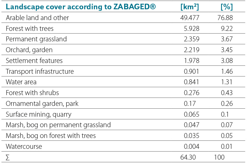
Several classifications with varying degrees of accuracy or generalization can be used for land cover. Here, ZABAGED®, CORINE Land Cover (CLC), and LPIS are used. In the Bečvárka river basin, the predominant land cover is classified according to ZABAGED® [7] as arable land and other areas (76.88 %), a significant part is also covered by forest land with trees (9.22 %), permanent grassland (3.67 %), orchards and gardens (3.45 %), and residential buildings (3.08 %). In contrast, the representation of, for example, swamps and marshes on permanent grassland (0.07 %), or on forest land with trees (0.05 %), is marginal. Water areas occupy 1.31 % of this basin (Tab. 2).
Tab. 2. Representation of land cover classified according to ZABAGED® in the Bečvárka water body basin
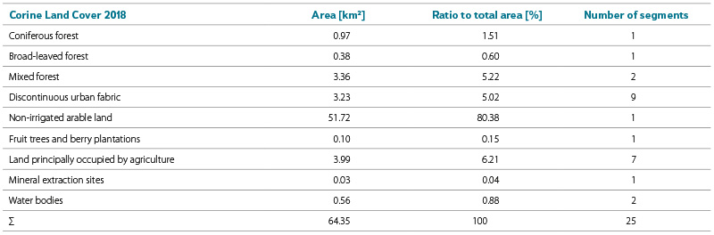
According to the CLC, which is largely generalized [8], the arable land class excluding irrigated areas prevails, covering 80.38 % of the basin. The following classes are: predominantly agricultural areas with an admixture of natural vegetation, mixed forests, and urban discontinuous development, each covering over 5 % of the basin area. Other classes occupy a very small part of the area. Water bodies make up 0.88 % of the basin and due to the generalization of this type of cover, with only two sites classified as water bodies. One is Mlýnský pond, near Bečváry, and the other is formed by the ponds of Utopenec and Stojespal, near Mlékovice (Fig. 3, Tab. 3).
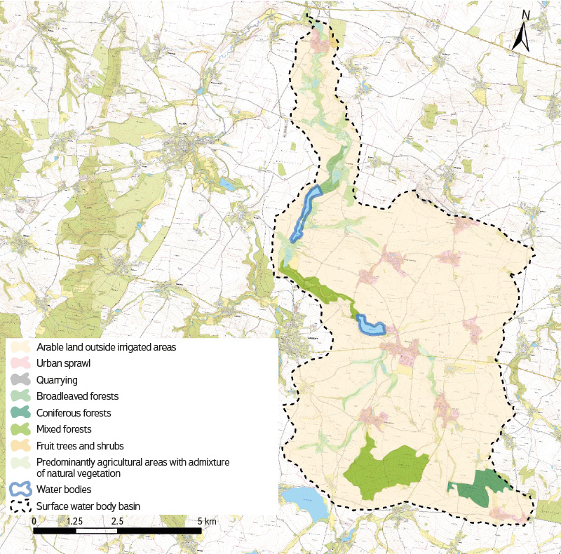
Fig. 3. CORINE Land Cover 2018 in the Bečvárka water body basin in the context of BTM 10
Tab. 3. Representation of CORINE Land Cover 2018 classes in the Bečvárka water body basin
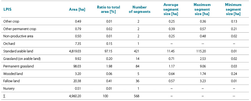
The LPIS records only agriculturally used areas for which economic agriculturalist entities receive subsidies [9]. It means that the entire area of the river basin is not covered by the LPIS, it is only 4,960.2 ha, which represents 77.14 % of the area. In the LPIS, the dominant land use is standard arable land (97.15 %), around 2 % is covered by permanent grassland, while the remaining land use types in the LPIS are negligible (Fig. 4, Tab. 4).
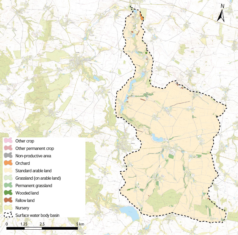
Fig. 4. Land use according to LPIS 2023 in the Bečvárka water body basin in the context of BTM 10
Tab. 4. Land use representation according to LPIS in the Bečvárka water body basin
Protected areas
There is only one natural monument in the described area (Fig. 2), namely Lůmek u Bečvár, which was declared on 12 December 1986 covering an area of 0.2499 ha with a legal protection zone of 2.1198 ha. The reason for the declaration was the occurrence of the rare griquaite rock and the rich deposit of Upper Cretaceous fossils [10].
METHODOLOGY
The first step of the research was the selection and subsequent comparison of the current and historical state of the ponds in the catchment area of this water body based on map interpretation. This was followed by a field survey of these sites to verify their current state. To detect the occurrence of historical ponds, the map of the 2nd Military Mapping was used, which is available for viewing on the National Geoportal INSPIRE [11] and also as WMTS [12]. Individual map sheets can also be obtained, which are available on the Oldmaps Application webpage of the Geoinformatics Laboratory of the Faculty of Environment, J. E. Purkyně University in Ústí nad Labem [13].
To display the current state, the latest Basic Topographic Map of the Czech Republic 1 : 10,000 (BTM 10) and the current Orthophoto map of the Czech Republic were used. Both maps are available as a WMS service from the ČÚZK Geoportal [14]. Only ponds with a minimum area of 0.5 ha were considered for the analyses. For a more accurate understanding of the landscape development between the state recorded for the 2nd Military Mapping and the current state, a historical orthophoto map from the 1950s was used. It is available for viewing on the National Geoportal INSPIRE [11] and also as WMTS [12]. Archive orthophoto maps from 1998–2022 are also available using WMS from the Geoportal ČÚZK [14].
To approximate the state of the landscape before the 2nd Military Mapping, especially with regard to the historical occurrence of ponds rather than their exact location, a positionally inaccurate map of Müller’s mapping was used, which can be viewed in the map viewer of the Land Surveying Office Archives [15].
Programs used and data processing
Georeferencing of archival maps and connecting current data using WMS or WMTS was carried out in the ArcGIS environment, specifically in the ArcMAP 10.8.2 program. This was followed by the creation of a polygon layer in .shp format. Each polygon was precisely defined by its identification number and the period in which it occurred in the area. The initial data processing was carried out in a GIS environment and involved calculating the area of polygons. The resulting values were then exported to Microsoft Excel 2016 and projected into tables.
Current maps used
Current BTM 10 and Orthophoto map of the Czech Republic
These maps are available as a WMS service from the ČÚZK Geoportal, where they are continuously updated according to the plan (in the case of BTM 10, approximately 1/3 of the Czech Republic per year). The displayed state on BTM 10 may vary both according to parts of the area and according to individual segments, which are updated separately, so it does not show the actual state of the landscape in all directions at a given moment. To process the current BTM 10, data capturing the status as of 6 July 2020 (centre), 10 October 2021 (east), and 2 January 2023 (west) were used. The update of significant elements of the topographic map (railways, roads under the administration of the Directorate of Roads and Highways of the Czech Republic) was carried out over the data documenting the status as of 2 January 2024. The displayed status corresponds to the ZABAGED® data. The entire orthophoto map of the Czech Republic is updated in a two-year cycle. Approximately half of the Czech Republic is updated annually and, since 2020, regional borders have been taken into account in the update. Currently, the western part of the Czech Republic (the border is formed by the Liberec, Central Bohemian, and South Bohemian regions) is covered with images showing the state of the landscape in 2023, while the eastern part shows the state of the landscape in 2024 [14].
Archival maps used
Müller’s mapping
The oldest map used here is Müller’s map of Bohemia from 1720 at a scale of approximately 1 : 132,000 [16]. A disadvantage for a detailed comparison of landscape development with subsequent map sources is its inadequate positional accuracy. Therefore, it can only be used to display water bodies as a supplement to newer data. Not all watercourses are depicted in it, the drawing is schematic and not entirely adequate [17].
2nd Military Mapping
This mapping brought the first relatively precise map. It was compiled between 1836 and 1852 at a scale of 1 : 28,800. Compared to the First Military Mapping, the accuracy of the depiction increased as a result of previous military triangulation. The 2nd Military Mapping took place at the onset of the Industrial Revolution and the development of intensive agriculture, when the area of arable land increased by half in 100 years and the area of forest reached a historical minimum. The maps also include oldest railway lines [13].
Historical orthophoto map from the 1950s
The historical orthophoto map is composed of aerial photographs originating mainly from 1952–1954, supplemented by images from 1937–1970 and 1996 where other sources are not available in the given period. This orthophoto map was created within the project “National Inventory of Contaminated Sites (NIKM)”. The aerial survey images were provided by the Military Geographical and Hydrometeorological Office (VGHMÚř) Dobruška and processed into an orthophoto map by GEODIS BRNO, spol. s r. o. [12, 14].
Archival orthophoto maps
These orthophoto maps are available as a set for 1998–2022. It is possible to select the display of layers according to the individual years of imaging. Only the part of the area that was imaged during one year is captured. In the layers from 1998 to 2001 the images are black and white, the layers from 2002 onwards contain colour images [14].
RESULTS
The historical pond system on the Bečvárka river recorded in the 2nd Military Mapping included a total of nine ponds (Mlýnský, Stojespal, Mlékovický, Svojšický, Rozkoš, Rybník, Bošický, Mlýnek, and Frčina). Other two ponds were not located directly on the Bečvárka river. Voděradský pond was located on the Voděradský stream immediately before its confluence with the Bečvárka river, and the pond in Poďousy was on the Poďouský stream. In total, there were eleven ponds covering an area of 65.28 ha. All of these ponds have survived to the present day (Fig. 5, Tab. 5), or rather, Mlékovický pond is still listed as a pond on current maps, as well as in the land register [18], although it has not been restored since 2013, when its dam was breached during a flood (Fig. 6) [19, 20], and this site is overgrown, i.e. it has been left to succession (Fig. 7–9) [20]. All the historical ponds are now smaller in size, with the exception of the Voděradský and Bošický ponds. Currently, compared to the situation recorded in the 2nd Military Mapping, five ponds with an area of over 0.5 ha have been added to the Bečvárka basin. For the evaluation of the pond system development on the Bečvárka, two ponds built close together (Horní and Dolní Kunvald) were considered as one object. Horní and Dolní Kunvald are on the upper reaches of the Bečvárka, while Utopenec pond is on the middle Bečvárka near Mlékovice, after Stojespal (Figs. 5 and 7). In terms of area, it ranks second only to the largest pond in the basin – Mlýnský pond near Bečváry. Medium-sized ponds include Bosňák on the Drahobudický stream (Fig. 10). The smallest new ponds are in Drahobudice and Dolní Chvatliny. The total area of the current ponds is approximately 11 ha larger than the area of the historical ponds, even though almost all individual historical ponds had an area larger than now (Fig. 5, Tab. 5). From the map comparison, it is clear that this reduction in the area of individual ponds is caused by the overgrowing of the littoral zone of the given historical pond. This can be clearly observed in particular at the ponds of Mlýnský, Rybník, and Stojespal (Figs. 7, 10, and 11). The current state of the ponds of Stojespal, Utopenec, Rybník, Rozkoš, Mlýnský, and Bosňák is shown in Figs. 12–17.
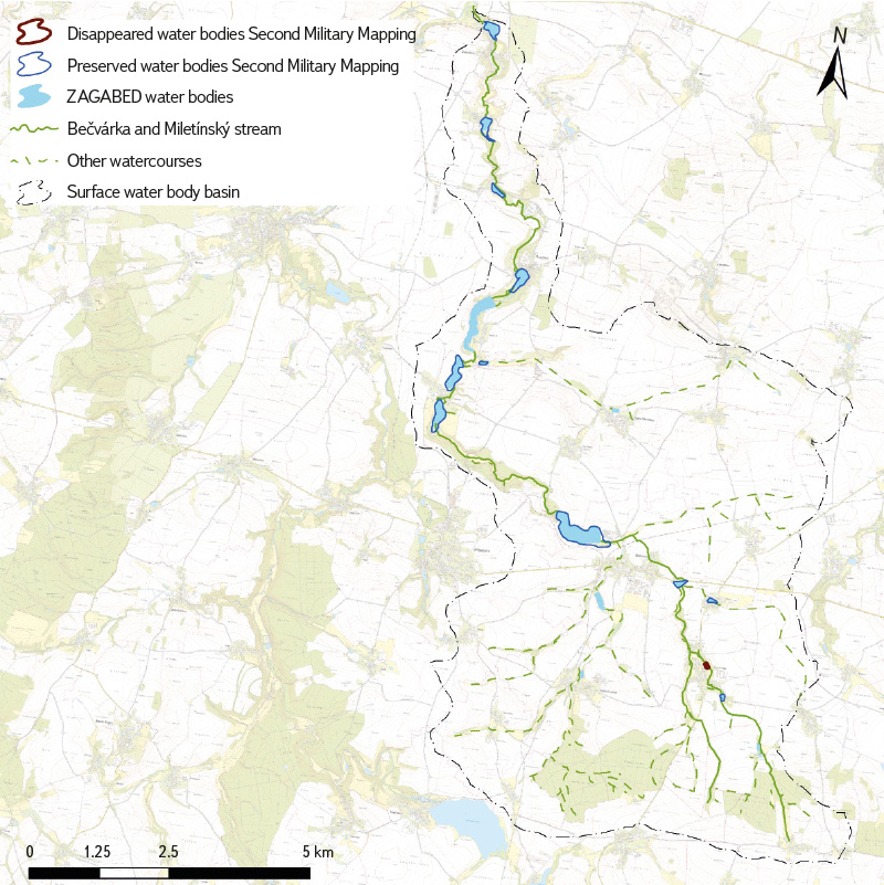
Fig. 5. Development of the pond system in the Bečvárka water body basin from the 2nd Military Mapping to the present in the context of BTM 10
Tab. 5. Development of the pond system area in the Bečvárka water body basin
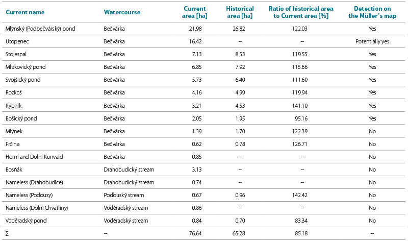
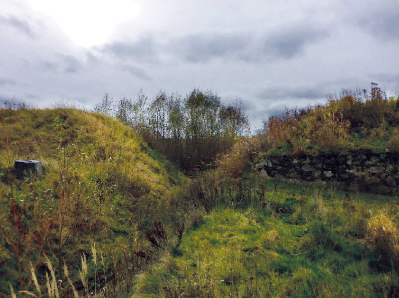
Fig. 6. The gap in Mlékovický Pond dam and the state of vegetation in the flooded area four years after the breach, as of 2017 [20]
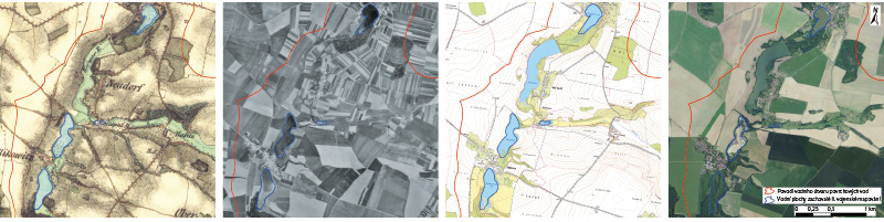
Fig. 7. Comparison of pond system development on the Bečvárka river near Mlékovice village, including the surrounding landscape, shown on a map of the 2nd Military Mapping, on a Historical Orthophotomap from the 1950s, on the current BTM 10, and on the current Orthophotomap of the Czech Republic
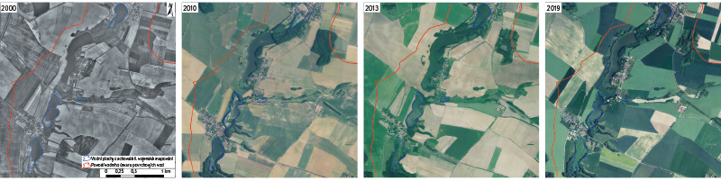
Fig. 8. Comparison of pond system development on the Bečvárka river near Mlékovice village, including the surrounding landscape, shown on Archival Orthophotomaps from 2000 to 2019
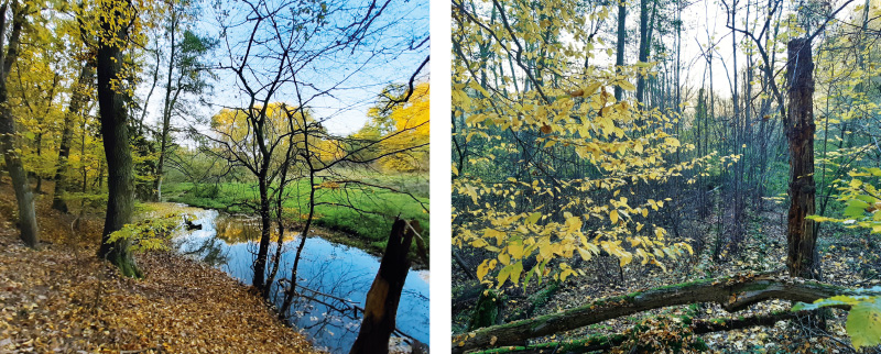
Fig. 9. The current state of Mlékovický pond (October 2024)
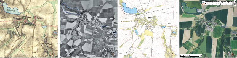
Fig. 10. Comparison of pond system development on the Bečvárka river near Bečváry village, including the surrounding landscape, shown on a map of the 2nd Military Mapping, on a Historical Orthophotomap from the 1950s, on the current BTM 10, and on the current Orthophotomap of the Czech Republic
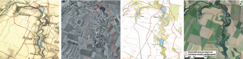
Fig. 11. Comparison of pond system development on the Bečvárka river near Žabonosy village, including the surrounding landscape, shown on a map of the 2nd Military Mapping, on a Historical Orthophotomap from the 1950s, on the current BTM 10, and on the current Orthophotomap of the Czech Republic
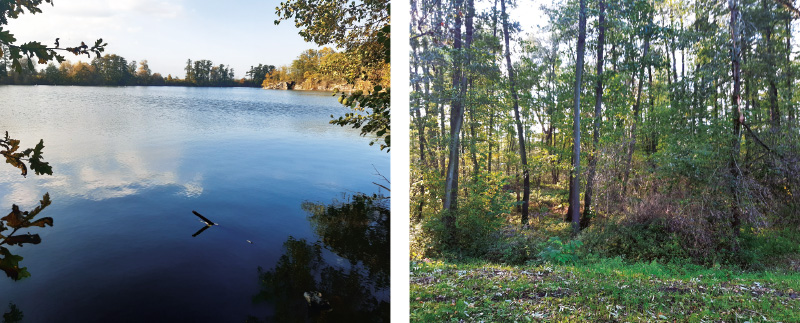
Fig. 12. The current state of Stojespal pond, including a disappeared historical part (October 2024)
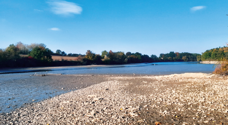
Fig. 13. The current state of Utopenec pond (October 2024)
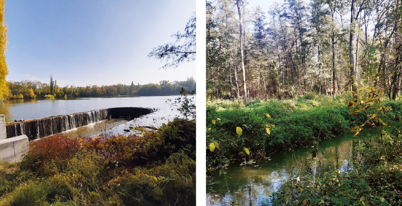
Fig. 14. The current state of Rybník pond, including a disappeared historical part (October 2024)
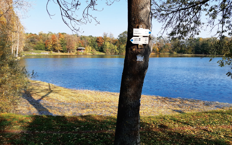
Fig. 15. The current state of Rozkoš pond (October 2024)
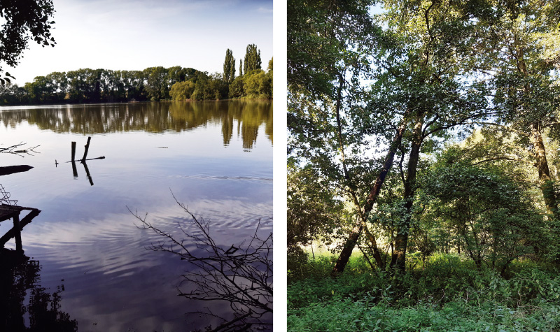
Fig. 16. The current state of Mlýnský pond, including a disappeared historical part (August 2024)
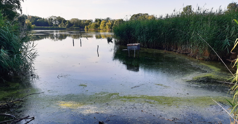
Fig. 17. The current state of Bosňák pond (August 2024)
Fig. 18 shows the state of the ponds on Müller’s map of Bohemia. From this map it can be concluded that the seven largest historical ponds on the Bečvárka already existed at the time of Müller’s mapping. In addition, the map shows that there was a smaller pond in the place of the current Utopenec pond, although this pond is not shown on the 2nd Military Mapping. A system of four ponds is drawn on Drahobudický stream, but none of them apparently corresponds to the location of the two current ponds.
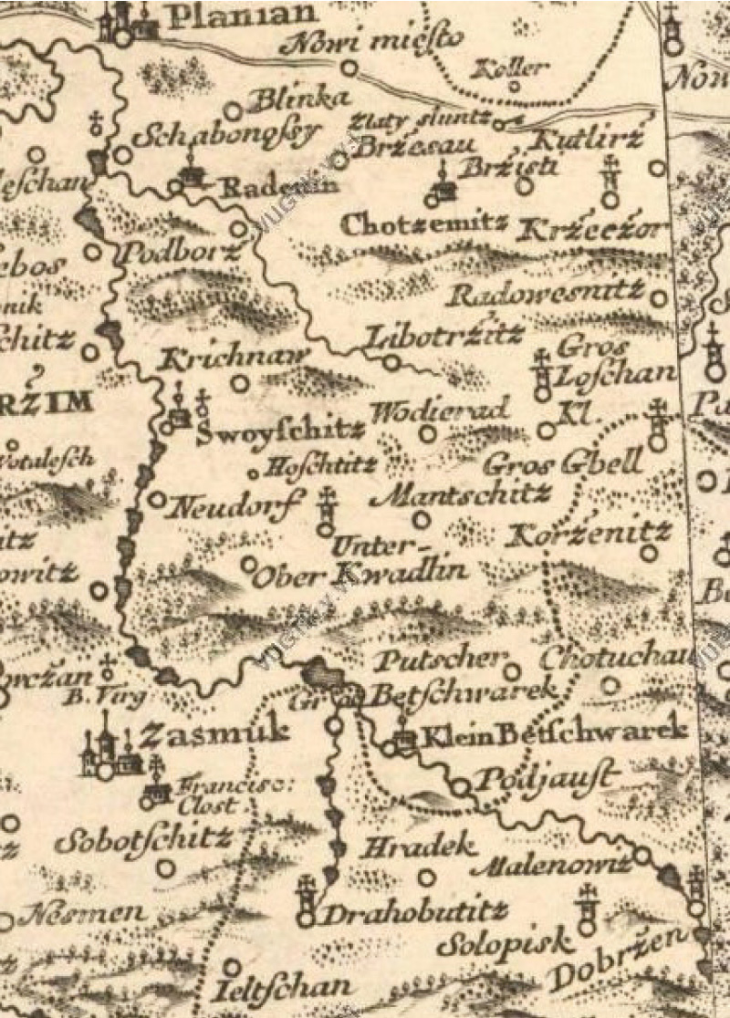
Fig. 18. The pond system in the Bečvárka water body basin on Müller‘s map of Bohemia [15]
DISCUSSION AND CONCLUSION
In the past, all artificially created water bodies with dams or excavated by human activity were considered ponds [21]. Currently, we have a large number of types of water bodies according to their use; at the same time, there are differences between the uses of water bodies designated as ponds. Even in the mid-19th century, the difference between a reservoir (fire, agricultural, etc.) and a pond (i.e. a water body intended exclusively for fish farming) was not yet clearly defined. We can therefore consider all water bodies depicted in the 2nd Military Mapping as ponds [21, 22]. However, in the Bečvárka river basin, there was no fundamental issue with distinguishing ponds from other water bodies, as most of them were preserved historical ponds. Any issues were also prevented by the definition of water bodies with a minimum area of 0.5 ha included in the evaluation. The only disappeared pond was the nameless pond in the village of Červený Hrádek. Due to its minimal area, almost exactly half a hectare, it was not considered for the evaluation of the pond system development in the Bečvárka river basin.
The historical pond system in the Bečvárka river basin recorded in the 2nd Military Mapping included a total of eleven ponds, nine of which were directly on the Bečvárka, covering a total area of 65.28 ha. All of these ponds have survived to the present day, although Mlékovický pond has had a ruptured dam since 2013, does not fulfill its original function, and its restoration is uncertain [20]. There are currently 16 ponds (including Mlékovický pond) in this basin with a total area of 76.64 ha; i.e., the area of ponds is currently larger than in the mid-19th century, while the current system of ponds is largely identical to the historical one.
To interpret these results, it is necessary to consider the fact that this is a comparison of only two initial states in terms of the temporal stability of the ponds, namely the 2nd Military Mapping period and the present. The area of the ponds was changing due to management; for example, the pond could have been landfilled and later restored. This could be the case of Voděradský pond, which is not only not visible on the orthophoto map from the 1950s, but its current area is larger than in the past (Fig. 7). Originally, there was also a longer-term discharge of ponds for the purpose of so-called summer drainage or silt removal, or the image could have been taken at the time of fishing, so the water body was not shown on the archive aerial photo. This is the case of Mlýnský pond in Fig. 10, again on the orthophoto map from the 1950s.
This pond system, with its development, deviates from the data otherwise valid for the entire Czech Republic, which state that the smallest area of ponds was in the mid-19th century and has been increasing slightly since then. Also, a significant part of the ponds recorded in the 2nd Military Mapping in lowlands have not been preserved to the present day [20, 21, 23, 24]. The pond system in the Bečvárka river also differs from the development of pond systems in the Polabian Lowland where, despite certain differences, historical ponds were disappearing significantly [2, 20, 21, 25–29]. A similar trend can be observed in the lowlands of the Morava river basin [30]. To a similarly sporadic extent as in the Bečvárka river basin, the disappearance or reduction of the area of historical ponds occurred only in the Třeboň region; however, the pond landscape there is much more extensive [20].
This fact seems paradoxical at first glance because this basin is used for intensive agriculture and is covered mainly by standard arable land. However, from Bečváry to the confluence with the Výrovka, the Bečvárka flows almost continuously through a relatively narrow and deep canyon, so there is no great pressure to landfill the ponds and replace them with arable land. It seems that in the context of ongoing climate change, such a robust pond system is probably oversized for a watercourse the size of the Bečvárka.
In this context, it can be considered that Mlékovický pond would not have to be restored and would become the subject of some form of protection within nature conservation associated with the appropriate management of this site. After twelve years of succession, this area is certainly more significant in terms of water retention in the landscape than as a pond used in the usual way for fish production today. Moreover, the restoration of the pond would be financially very demanding, given its current state. However, the owner of the pond is a large regional fishing company that manages a significant part of the ponds in the area. Such a solution, respecting the current state, would therefore probably also represent a large financial burden associated with the necessary change of owner.
Acknowledgements
The article was created as part of the research of the Centre for Landscape and Biodiversity (TA CR No. SS02030018) with the support of TGM WRI internal grants No. 3600.23/2024 and No. 3600. 23/2025 (Research Support – Institutional Support, Department 230).
The Czech version of this article was peer-reviewed, the English version was translated from the Czech original by Environmental Translation Ltd.
