
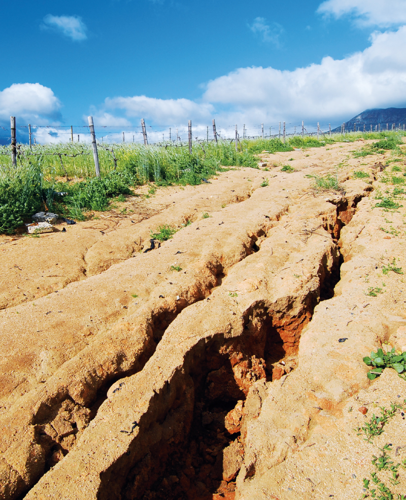
Typology and effects of roads on runoff regime in protected areas
The article presents the results of the project Analysis of Changes in the Water Regime of Land and Watercourses in the Krkonoše National Park Caused by the Network of Roads (TA CR, no. TITSMZP945), implemented as a public procurement commissioned by the Ministry of the Environment of the Czech Republic within the BETA2 applied research programme. The main output of the project is a two‑level typology of the road network in terms of its impact on surface and subsurface runoff. This typology was applied to the territory of Krkonoše National Park (KRNAP) in the Czech Republic and presented in the form of cartographic atlases. The article describes the principles and criteria of the proposed typology and the methodology of its application in map production, which at the basic level combines spatial analyses of road network datasets, digital terrain models and the hydrographic network, and at the detailed level incorporates the results of extensive field surveys. The original analytical procedures include, among other things, the detection of directional and elevation breaks in road segments and the delineation of micro‑catchments for individual sections. The resulting maps provide KRNAP Administration and other managers of protected areas with a tool for identifying road segments with the highest potential impact on the hydrological regime and serve as a basis for planning compensatory measures or restoration interventions.

The potential of grass strips for retaining surface runoff and sediment
The use of grass strips in agricultural landscapes is widely recognized for their ability to effectively reduce surface runoff and the transport of eroded particles, while simultaneously enhancing biodiversity and landscape stability. This study aimed to quantify the impact of grass strip length on sediment retention in surface runoff. Experimental measurements were conducted on enclosed plots measuring 8 × 1 metres, each with varying proportions of grass cover to simulate different grass strip widths under real-world conditions.
Mini-JET device as a tool for determination of soil erodibility characteristics
The article describes a method for determining the erodibility of incohesive agricultural soils by means of the critical shear stress measuring. The “Jet Erosion Test” (JET) was used to determine the critical shear stress. The mea- surement was performed using a modified Mini-JET device. The device is very suitable for field measurements, because it is small, light, requires a relatively small amount of water, and can be operated by single person. The principle of measuring the critical shear stress of the soil is based on monitoring the rate of erosion crater formation by the action of a water jet of known kinetic energy. Based on the erosion crater development, the erosion parameters of the soil, such as the critical shear stress and the erodibility coefficient, can be calculated.

Determination of the extent of soil unprotected by vegetation in the period of rainstorms to assess erosion risk
Článek popisuje metodu, zdrojová data i výsledky analýzy erozní ohroženosti podle nové metodiky využití dálkového průzkumu Země pro ochranu zemědělské půdy. Metoda je testována na pozemcích AGRA Řisuty, s. r. o. Pro zjištění přítomnosti vegetačního pokryvu na jednotlivých půdních blocích či jejich částech jsou využívána data z družic Landsat 8 a Sentinel 2.
River basin monitoring to assess the impact of nature-friendly measures
As part of the Drought project, a comprehensive monitoring of watercourses and land in their catchment areas was launched in the Czech Republic to assess the impact of the implementation of revitalization actions to protect against the effects of drought.
Agriculture bare soil surface evaluation using stereophotogrammetry
The article deals with the development of agriculture bare soil surface using the stereophotogrammetric method. It describes and compares the development of selected soil characteristics investigated on four types of field cultivation.
The importance of catchment characteristics in terms of intensive erosion runoff formation threat level
We located almost 130 000 critical localities near to urban areas where eroded material can enter the urban area. These localities were divided into five threat categories. Detailed modelling by WaTEM/SEDEM provided an extensive database of almost 130 000 micro catchments with outlet profiles threatened by intensive erosion runoff, and classified by five categories of threat for infrastructure damages.