

ABSTRACT
This article compares the condition of selected spring areas following sudden major disturbances with their previous condition, while also assessing long-term changes in drained and undrained spring areas. The impacts examined include major changes in groundwater abstraction for drinking-water supply, disturbances resulting from failures of drainage systems, and the effects of a large-scale forest fire. Three areas with contrasting hydrogeological characteristics were selected for the study. The results show that, while the abstraction of spring water for drinking-water supply has a fundamental effect on the very existence of springs, the large-scale forest fire did not significantly affect either the quality or quantity of groundwater. By contrast, gradual changes in agricultural management and the natural recovery of non-functioning drainage systems lead to the formation of secondary spring areas and a gradual improvement in the quality of the emerging water.
INTRODUCTION
A spring is a concentrated point of emergence of groundwater at the Earth’s surface, representing a unique and highly vulnerable habitat at the interface between groundwater, surface water, and terrestrial ecosystems [1–3]. Springs are susceptible to a range of changes, including contamination of groundwater from the surface, changes in discharge resulting from damage to the underlying aquitard, and changes in the way springs are captured, as well as many other, mostly anthropogenic, factors. Particularly since the 19th century, with the development of agricultural needs and public water supply, spring areas throughout Europe have undergone widespread transformation [3]. In addition, the Czech Republic has been heavily affected, from lowlands to foothill areas, by systematic large-scale drainage, which peaked in the second half of the 20th century [4, 5].
These disrupted ecological processes are now manifested not only in a decline in local biodiversity but, in the context of ongoing climate change, also in a reduced ability of the landscape to cope with hydrological extremes such as floods and prolonged droughts. The conservation and restoration of natural spring areas are therefore crucial, as these sites function as reliable, thermally stable hydrological refugia [6]. This article focuses on changes in selected springs, particularly those resulting from spring capture and significant groundwater abstraction in their vicinity; the effects of a large-scale fire on selected springs were also examined, as were the effects of historical drainage and the current restoration of these springs. The springs investigated had been mapped and studied in previous research, e.g. [7–14]. The current research is part of the TA CR Environment for Life II project, No. SQ01010130.
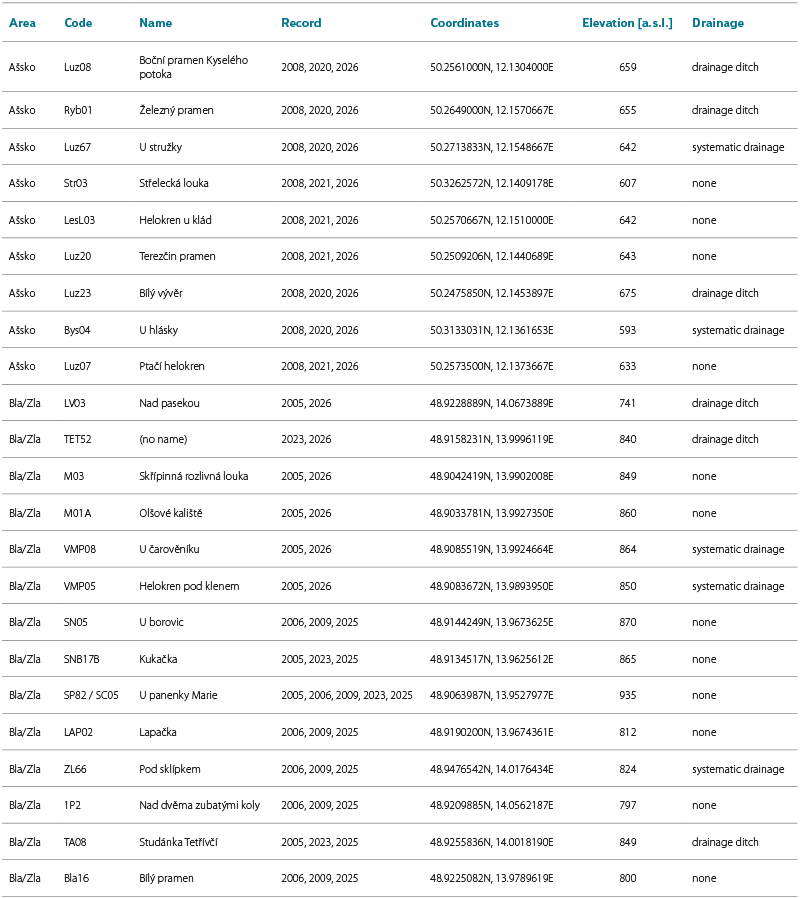
Tab. 1. Basic characteristics of spring areas affected and unaffected by drainage in the Aš area and the upper Blanice and Zlatý stream catchments
METHODOLOGY
The main objective of this study is to assess and compare the impacts of sudden environmental disturbances (forest fire and intensive groundwater abstraction) and long-term landscape changes (large-scale drainage and subsequent natural recovery) on the hydrochemical status of springs and, where applicable, their discharge.
The springs selected for further study were primarily those for which we had documented the baseline conditions prior to significant changes. All available archival materials were reviewed and analysed and compared with the current conditions.
In 2026, a comprehensive standardised form was completed for all springs investigated. It included not only information on the location and extent of the spring areas and the results of field measurements of water parameters, but also a description and basic quantification of the biological components of the natural environment.
At the selected springs, discharge and the physical and chemical properties of the water were measured, and water samples were collected for chemical analysis. During repeated visits to the springs, their discharge was measured using a suitable measuring container, along with water parameters including electrical conductivity, temperature and, where applicable, pH and dissolved oxygen.
For the study, three areas with markedly different hydrogeological characteristics were selected. The study area around Hřensko in northern Bohemia forms part of the Czech Cretaceous Basin, with significant deep hydrogeological structures and a greater delay in the response of spring discharge to precipitation and is located within a national park. In the Hřensko area, eight springs with high discharge at different altitudes were monitored directly as part of the ongoing project. Other springs were inaccessible for monitoring and were therefore assessed using only archival data and supporting materials.
In the Hřensko area, the impact of the large-scale wildfire on springs was investigated. This involved comparing our own field measurements and the results of water analyses with archival sources of expert information, as well as data from the Raw Water Database and, last but not least, freely available data from the Czech Hydrometeorological Institute (CHMI).
Another selected spring area was the Aš region in western Bohemia, which is located in an area of crystalline rocks (underlain by low-grade metamorphic phyllites and schists), where springs are generally highly dependent on climatic conditions. In the recent past, major changes in agricultural management took place here, affecting the springs, and the area is also home to specially protected organisms associated with aquatic environments.
The third study area was the Blanice catchment in the Šumava foothills. From a hydrogeological perspective, it lies within the crystalline basement, in an area of highly metamorphosed rocks of the Moldanubian Zone (migmatites, granulites, etc.). The area is situated at a higher altitude than the two previous areas and is therefore slightly wetter and cooler.
For comparison of water quality at spring areas affected and unaffected by drainage, data from two periods 16–20 years apart were obtained. The first period covers the beginning of monitoring between 2005 and 2009. The comparison dataset is current, covering 2025/2026. The data include individual spring areas from two study regions: the Aš region and the Blanice and Zlatý Stream catchments. The following water-quality parameters were selected: conductivity, nitrate, nitrite, ammonium-ion, phosphate and chloride concentrations. For the calculation of the resulting score, indicating an improvement or deterioration in the hydrochemical status of the spring area, only those parameters for which data from the first period were available were used (Tab. 2). Where data from multiple seasons were available for a given spring area within a particular period, the mean values were used. Individual parameters were assigned one or two positive or negative points depending on the magnitude of the improvement or deterioration. Where a parameter remained unchanged (or the change was negligible), it was assigned zero points. The theoretical score could therefore range from −12 (significant deterioration in all monitored parameters) to +12 (significant improvement in all monitored parameters).
Tab. 2. Chemical water-quality parameters in selected spring areas during the two monitoring periods
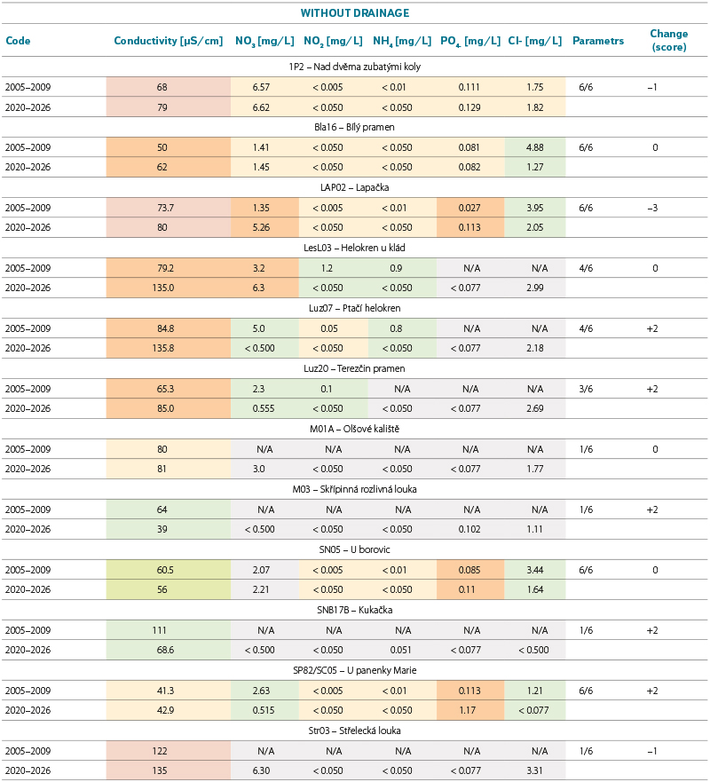
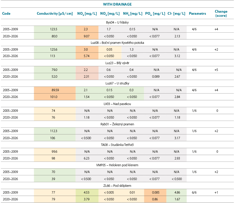
The spring areas investigated were divided into two categories according to whether or not they were affected by drainage. In this context, drainage refers both to systematic subsurface drainage systems and to deepened surface ditches conveying water to a receiving watercourse. In addition to entirely natural spring areas, the unaffected category also included spring SP82/SC05 (U panenky Marie), which has been modified as a drinking-water spring, but is not affected by drainage in any way.
RESULTS FOR THE SELECTED SPRING AREAS
Study area around Hřensko
The study area east of the town of Hřensko is in the Ústí nad Labem Region, within Bohemian Switzerland National Park.
From a hydrological perspective, the springs investigated are located in the Dlouhá Bělá Stream catchment. The stream flows into the Hřenská Kamenice from the right at Hřensko, just over one kilometre upstream of its confluence with the Elbe river. The Suchá Bělá stream is a right-bank tributary of the Dlouhá Bělá, and its catchment contains five of the springs investigated. In total, eight high-discharge springs were monitored directly as part of the project. Some other historical springs were inaccessible for direct monitoring, particularly because they are used for groundwater abstraction for public drinking-water supply.
From a hydrogeological perspective, the study area is part of the Czech Cretaceous Basin and lies in the northern part of Hydrogeological Region 4660 – Lower Kamenice and Křinice Cretaceous Basin and Groundwater Body 46600 – Lower Kamenice and Křinice Cretaceous Basin [15]. The hydrogeologically significant aquifers in the study area occur in psammitic Cretaceous rocks, particularly sandstones, with intergranular and fracture permeability. The springs studied are associated with the locally most important aquifer (BC), hosted in the sandstones of the Jizera Formation and the upper part of the Bílá Hora Formation [16]. The high-discharge springs of interest occur at aquitard layers within the BC aquifer, as described, for example, in more detailed Saxon geological and hydrogeological studies [10].
Evolution of the springs east of Hřensko
The earliest available study of the springs [7] provides a clear picture of their condition more than 100 years ago. It describes the following situation in 1911–1912: the settlement of Hřensko already had a public water supply fed by a captured spring in the upper part of Malinový důl (the Nad Klepáčem spring; see Fig. 4). The author classifies it as a contact spring emerging at the outcrop of an overlying sandstone layer underlain by a clay layer.
One of the highest-discharge springs in the area was the Tři prameny spring area (Pod Pravčickou bránou spring), at an elevation of 200 m above sea level. Near the junction of the hiking trail to Pravčická brána and the Dlouhá Bělá stream, a powerful spring emerged from a rocky slope covered with scree, forming a small pond inhabited by trout and covered with aquatic vegetation. The original three outlets of the spring area had already been artificially combined. The spring discharge was at least 6 L/s, and the water temperature on 6 March 1912 was 8 °C. The author concludes that it is a contact spring emerging at the outcrop of a sandstone layer (Labiatus).
One of the best-known springs in Saxon-Bohemian Switzerland was Panenský spring (elevation 185 m above sea level), which had already been modified at the time, with its banks artificially widened. Clear water emerged from the ground at several points, playing over white pebbles at the spring outlets. The spring discharge was similar to that of Tři prameny. On 3 February 1911, the water temperature at the strongest outlet of Panenský spring was measured at 9.05 °C. From this, the author concluded that it was an ascending spring, since under normal conditions its temperature would be expected to be only around 7.5 °C. In the Suchá Bělá valley, about 200 metres from its confluence with the Dlouhá Bělá, a spring (Suchá Bělá 3) emerged from scree, with a discharge of around 2 L/s [7].
In the late 1960s and early 1970s, a series of hydrogeological investigations were conducted in the study area, including monitoring of some of the major local springs (e.g. [9] and other studies [21]). Borehole drilling and other hydrogeological work led to the establishment of the extensive Hřensko groundwater abstraction area. Groundwater was, and continues to be, abstracted here from a system of hydrogeological boreholes in the Dlouhá Bělá valley. The high-discharge Pod Pravčickou bránou (Tři prameny) and Pytlův springs were subsequently incorporated into the system. Since the second half of the 20th century, the Hřensko abstraction area has supplied drinking water to the town of Děčín and the surrounding area.
Around the groundwater abstraction area, seven springs were monitored regularly once a week in the late 1960s and early 1970s (Panenský spring, Suchá Bělá 1–3, Pod Pravčickou bránou spring, Pytlův spring and U Cikánského smrku spring). Their former locations are shown on the historical map in Fig. 1. Panenský spring disappeared completely as a result of groundwater abstraction and was decommissioned in 1974 [20]. The monitored springs were gradually removed from the monitoring programme. Of these, only Suchá Bělá 3 continues to be monitored regularly by the CHMI.
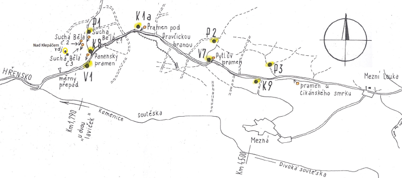
Fig. 1. Historical map showing the locations of springs around Hřensko (source: [21])
The discharge of Suchá Bělá 2 spring gradually declined from 3.8 L/s in 1960 until surface discharge ceased completely in 1989. This was most likely due to a combination of increased groundwater abstraction from the Hřensko abstraction area (up to 135 L/s) and unfavourable climatic conditions [10]. Following a reduction in groundwater abstraction and the end of the dry period, the discharge of Suchá Bělá 2 spring increased slightly again.
The discharge of some other major springs responded similarly to high levels of groundwater abstraction and unfavourable climatic conditions. Pod Pravčickou bránou spring, which has the highest discharge in the area, had a discharge of approximately 20 L/s in the late 1970s and early 1980s, compared with only around 10.6 L/s in 2013. The discharge of U Cikánského smrku spring generally fluctuated between 0.5 and 3.3 L/s from 1957 to 1982, whereas in 2012–2014 the mean discharge was only 0.22 L/s.
Between 2012 and 2014, springs in the area were mapped and their discharge measured and assessed as part of the cross-border GRACE programme [8, 10].
In the early 2020s, the area was affected by a bark beetle outbreak. In July 2022, the resulting dry woody biomass was consumed by a large-scale wildfire covering more than 10 km² (e.g. [18]), which, with a few exceptions, affected the entire study area from the built-up area of Hřensko to that of Mezná village.

Fig. 2a. Changes in pH of abstracted groundwater sources near Hřensko before and after the fire (data source: [22])

Fig. 2b. Changes in conductivity of water from abstracted groundwater sources near Hřensko before and after the fire (data source: [22])
Current status of springs in the Hřensko area
Panenský spring has disappeared as a result of groundwater abstraction, and no traces of it remain at the site of its former outflow. Nad Klepáčem spring area in Malinový důl is used as a source of drinking water for the town of Hřensko. The main surface outflow from this spring area has disappeared (the spring intake is shown in Fig. 4). Groundwater outflows with substantially lower discharge occur within the spring area, but infiltrate back into the rock environment after several tens of metres. After abstraction, the overflow from the main spring is discharged unused through a pipe into the Dlouhá Bělá stream. Pod Pravčickou bránou spring (Tři prameny) and Pytlův spring are fenced off, covered by chambers and soil, and connected to the public water supply system; consequently, there are no longer any surface groundwater outflows at these sites (Fig. 5). U Cikánského smrku spring still exists in a degraded state (a concrete well ring; see Fig. 6) and has a markedly lower discharge than in the last century. The five high-discharge springs monitored in the Suchá Bělá valley flow freely onto the surface without any significant restrictions. The highest-discharge spring, Suchá Bělá 3, is regularly monitored by CHMI. Groundwater abstraction from the Hřensko abstraction area has decreased compared with the past and is currently around 80 l/s [17]. Even several years after the fire, much of the area remains covered with charred wood debris. Scorched tree trunks rise towards the sky, with vegetation gradually regenerating between them, particularly through self-seeding birch (Figs. 5 and 6).
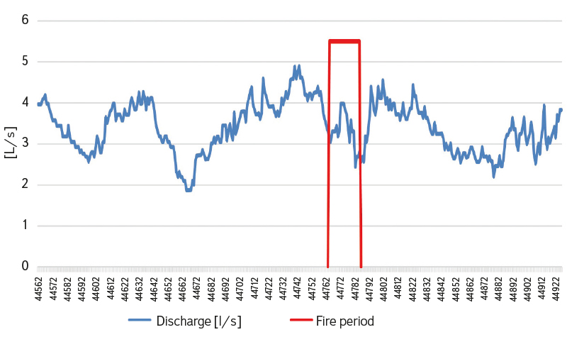
Fig. 3. Fluctuation in the discharge of the Suchá Bělá 3 spring in 2022 (data source: CHMI)
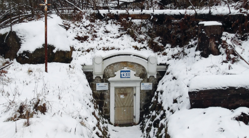
Fig. 4. Historical capture structure at Nad Klepáčem spring near Hřensko; condition in February 2026 (photo: P. Eckhardt)
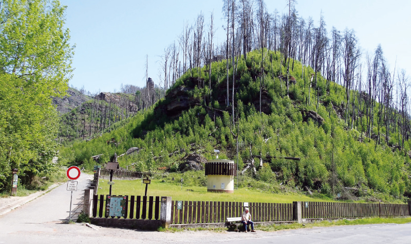
Fig. 5. Pod Pravčickou bránou spring site near Hřensko, currently with no water emerging at the surface, status in May 2026 (photo: P. Eckhardt)
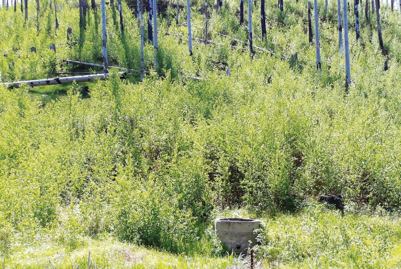
Fig. 6. Concrete well ring at U Cikánského smrku spring in the Hřensko study area, May 2026 (photo: P. Eckhardt)
Potential effects of the fire on spring water quality
The large-scale fire, which burned from 24 July to 12 August 2022, affected an area of more than 10 km² around the monitored springs east of the town of Hřensko [18]. It was the largest forest fire recorded in Czechia in modern times.
Fires can generally affect groundwater, particularly through contamination by substances contained in smoke and ash (toxic metals, polycyclic aromatic hydrocarbons, etc.). Infiltration of firefighting water and fire-suppressing agents may also play a role [19]. In this case, water from the Elbe river, Lake Milada and other sources was used to extinguish the fire.
Evaluation of data from the Raw Water Database
To assess changes in water chemistry, analytical data on abstracted groundwater from the Raw Water Database [22] were available for the captured springs. The database contains data for Nad Klepáčem spring (a drinking-water source for Hřensko) and the Hřensko abstraction area, into which the high-discharge Pod Pravčickou bránou and Pytlův springs are incorporated. Within the study area affected by the fire, the Mezná abstraction area is also monitored in this way; it abstracts groundwater from a hydrogeological borehole east of U Cikánského smrku spring. Results from the Mezná abstraction area were therefore also included for comparison in the assessment of the effects of the fire on groundwater (see, for example, the graphs in Figs. 2a and 2b).
The three groundwater sources mentioned above abstract groundwater with low mineralisation and low pH. Groundwater from these sources was sampled both before the fire (analyses from 2019 to spring 2022 were considered) and after the fire (analyses from autumn 2022 and 2023).
Nad Klepáčem captured spring
The pH of water abstracted from Nad Klepáčem spring area was around 5.8 before the fire and decreased slightly to 5.7 after the fire (Fig. 2a). Water conductivity gradually increased slightly between autumn 2019 and spring 2022, reaching 16.7 mS/m before the fire. After the fire, it decreased to 15.3 mS/m before returning to around 16.3 mS/m in 2023 (Fig. 2b).
In 2022, following the fire, chloride concentrations increased slightly compared with pre-fire levels (from 4.47 to 5.35 mg/L), while sulphate concentrations decreased slightly (from 46.7 to 40.7 mg/L). Nitrate concentrations were identical before and after the fire (11.5 mg/L). Magnesium concentrations fluctuated around 3 mg/L both before and after the fire. Concentrations of ammonium ions, nitrites, aluminium and manganese were below the analytical detection limit both before and after the fire. No Escherichia coli or enterococci were detected either before or after the fire.
In autumn 2022, slight increases were recorded in the concentrations of iron (from < 0.02 to 0.07 mg/L), calcium (from 18.4 to 20.2 mg/L), the sum of Ca + Mg (from 0.58 to 0.63 mmol/L), and CODMn (from < 0.5 to 0.71 mg/L) in water abstracted from Nad Klepáčem spring. However, all these parameters returned to their previous typical levels in 2023.
In October 2022, a broader range of analyses was conducted, confirming the absence of significant concentrations of polycyclic aromatic hydrocarbons (PAHs), nickel, lead, zinc, phosphates, boron, copper, mercury, fluorides, selenium, chromium, cadmium, cyanides and beryllium in the abstracted water.
When compared with the requirements of Decree No. 252/2004 Coll. [20], the abstracted water failed to meet the same parameters both before and after the fire. These included, in particular, low pH and low magnesium concentrations, which were attributable to the natural background conditions.
Groundwater from the Hřensko abstraction area
In the Hřensko abstraction area, most groundwater is abstracted by pumping from hydrogeological boreholes. In 2022, the mean abstraction rate from this area was 75.7 L/s [17]. The discharge of the two captured springs (Pod Pravčickou bránou and Pytlův) is not measured but calculated, which our findings indicate is unreliable [8]. Based on expert estimates, spring water accounts for approximately one seventh of the total volume abstracted. Any contamination of the springs resulting from the fire could therefore be reflected in the results for the mixed abstracted groundwater, but only to a limited extent due to substantial dilution by groundwater pumped from the boreholes. In 2022, water analyses were conducted both before the fire (March and 14 July) and after the fire (September and October 2022).
The raw water from the Hřensko abstraction area was weakly mineralised and slightly acidic both before and after the fire. Comparison of the values before and after the fire showed a slight decrease in pH (from 6.3 to 6.0), followed by a return to the initial level (Fig. 2a). Similarly, the conductivity of the groundwater decreased after the fire and then returned relatively quickly to its previous level (Fig. 2b). The graphs also show an isolated sharp increase in both pH and conductivity in September 2023 (more than a year after the fire), which, in view of the preceding and subsequent measurements, we interpret as a probable measurement or database entry error.
For comparison, conductivity in the Mezná abstraction area decreased after the fire in a similar manner to that in the Hřensko abstraction area (Fig. 2b). By contrast, the decrease in pH after the fire was considerably greater in the Mezná abstraction area (from 6.6 to 6.0), falling well below the minimum limit for drinking water specified in Decree No. 252/2004 Coll. [20].
Both before and after the fire, groundwater from the Hřensko abstraction area had favourably low concentrations of nitrates, nitrites, ammonium ions, phosphates, sulphates, chlorides, iron, manganese, toxic metals and selected bacteria, as well as a wide range of other parameters analysed.
When compared with the requirements of Decree No. 252/2004 Coll. [20], the water from the Hřensko abstraction area failed to meet the same criteria both before and after the fire, including pH below the specified range and low calcium and magnesium concentrations, all of which are of natural origin. The raw water is treated before being supplied to the public water-supply system to ensure compliance with the requirements of the Decree [20]. Water analyses show that the fire did not cause any significant changes in the quality of water from the Hřensko abstraction area.
Overall, the differences in the quality of groundwater from the monitored sources incorporating captured springs before and after the fire near Hřensko were not significant, although some short-term adverse changes were observed. A marked decrease in groundwater pH after the fire was recorded in the Mezná abstraction area, which, however, does not abstract water from springs.
Suchá Bělá 3 spring
The high-discharge Suchá Bělá 3 spring (database number PP0552) has been monitored by CHMI over the long term. The spring has been modified for monitoring purposes, with both its discharge and water quality being monitored. Daily discharge data and the results of chemical and bacteriological analyses, generally conducted once or twice a year, are freely available for the study period (2019–2024) from the CHMI hydrological database (https://hydro.chmi.cz/hpps).
The discharge of Suchá Bělá 3 spring fluctuated slightly around a mean value of 4.3 L/s between 2013 and 2024. During some periods, discharge increased to more than 5 L/s, while at other times it fell to just above 3 L/s. The only period in which discharge fell below 3 L/s was during the study year 2022 (Fig. 3). Marked decreases in discharge had already occurred before the fire, falling to 2.5 L/s in February and subsequently to below 2 L/s, with the annual minimum occurring in mid-April. Discharge then gradually increased to an annual maximum of approximately 4.8 L/s around the end of June and beginning of July, followed by a decrease to around 3 L/s in mid-July. During the fire in late July, spring discharge increased from 3.18 L/s to almost 4 L/s before falling to 2.44 L/s in early August, including a very marked daily decrease of as much as 0.9 L/s. After the fire, discharge increased to the usual level of around 4 L/s in the second half of August, before declining to the second-lowest annual value in November and then returning to usual levels by the end of December. In our opinion, the daily discharge data recorded during the fire should be interpreted with caution, particularly given the possible sensitivity of the automatic measuring equipment to changes such as trees and branches falling into the measuring structure or firefighting activities (e.g. the use of water). Nevertheless, it is apparent that the more pronounced absolute changes in spring discharge in 2022 occurred not during the fire itself, but in the periods before and after it.
Water quality was compared primarily using analytical results from October 2021 (well before the fire), May 2022 (the last analysis before the fire), October 2022 (the first analysis after the fire) and May 2024 (the second analysis after the fire).
The spring water was weakly mineralised and slightly acidic (pH around 6) both before and after the fire. Concentrations of ammonium ions, nitrites, fluorides, dissolved organic carbon and phosphates, as well as acid neutralising capacity to pH 4.5 and base neutralising capacity to pH 8.3, remained consistently below the laboratory detection limits both before and after the fire. Similar levels before and after the fire were recorded for bicarbonates (around 5 mg/L), magnesium (approximately 1.7 mg/L), potassium (around 2.5 mg/L), sodium (approximately 2.8 mg/L), carbonates and total hardness (around 0.26 mval/L). Slight increases after the fire were recorded in nitrate concentrations (from 10 to 11 mg/L), calcium (from 6.75 to 7.75 and subsequently 8.11 mg/L), chlorides (to above 4 mg/L) and sulphates (from 17.9 to 18.5 mg/L). CODMn increased from approximately 0.5 mg/L before the fire to 0.62 mg/L in October after the fire, before decreasing to 0.54 mg/L in 2024.
No analysis of metals and other elements is available for the period shortly after the fire. However, both before the fire (October 2021 and May 2022) and in May 2024, concentrations of antimony, arsenic, boron, chromium, cadmium, cobalt, lithium, manganese, copper, molybdenum, nickel, lead, selenium, vanadium, zinc and iron were below the laboratory detection limits after filtration. Similarly, anionic surfactants, the pesticides analysed, chlorinated aliphatic hydrocarbons, simple aromatic hydrocarbons, chlorinated benzenes and other substances were below the detection limits.
Comparison with the drinking-water limits [20] showed no change in the assessment of the water quality of Suchá Bělá 3 spring before and after the fire. The water failed to meet the requirements primarily because of its low pH (below the specified range), magnesium concentrations below the minimum limit, and calcium and magnesium concentrations below the recommended ranges. These deviations are of natural origin.
Springs monitored in the Spring Areas project
During fieldwork in the first half of 2026, water parameters were measured at eight major freely accessible springs in the study area that had been monitored previously. Samples for chemical analysis were collected from six of these springs.
Recent analyses of groundwater from the five springs in the Suchá Bělá valley showed similar characteristics. The pH was slightly acidic, ranging from 5.8 to 6.0, and water conductivity was low (8.7–10.0 mS/m). Concentrations of ammonium ions and nitrites were below the analytical detection limit (< 0.05 mg/L), as were concentrations of phosphates and total phosphorus (< 0.025 mg/L) and aluminium (< 0.005 mg/L). Nitrate concentrations were only around 10 mg/L, while calcium concentrations were around 8 mg/L and magnesium around 1.6 mg/L. The groundwater at Nad Klepáčem spring originates from a higher level of the sandstone complex. Compared with the springs in the Suchá Bělá valley, water sampled from the smaller outlets of Nad Klepáčem spring area had higher conductivity (16.8 mS/m) and higher calcium and magnesium concentrations, consistent with the characteristics described above based on data from [22].
Comparison of the parameters of emerging groundwater measured in the field using the same method (in each case, the mean of at least three sets of spot measurements taken at different times) in 2012–2014 (well before the fire) and in 2026 (well after the fire) showed the following:
Measured discharge remained broadly similar between 2012–2014 and 2026 at four springs, including Suchá Bělá 3 spring (approximately 3.9 L/s) and U Cikánského smrku spring (approximately 0.22 L/s). At two of the monitored springs, measured discharge decreased markedly, including Suchá Bělá 2 spring (from 1.2 to 0.5 L/s). By contrast, discharge increased markedly at two other monitored springs.
Mean measured water conductivity increased slightly compared with 2012–2014. For example, at Suchá Bělá 2 spring, it increased from a mean of 7.75 to 9.0 mS/m. The higher-elevation springs in the area have higher water conductivity; for example, at U Cikánského smrku spring, the mean increased from 19.55 to 22.2 mS/m. The slight increase in conductivity is probably unrelated to the fire; data from more frequently monitored springs (e.g. Nad Klepáčem) suggest that it is more likely part of a longer-term trend.
Overall, the differences in groundwater quality at the monitored springs before and after the fire were not considered significant.
Aš study area
To compare changes in spring areas that are demonstrably occurring and measurable, but do not result from sudden disturbances, we selected two areas for which both older and more recent data are available. The first study area, around the town of Aš, is located in the Cheb District of the Karlovy Vary Region. The older, incomplete dataset available to us comes from spring-area mapping conducted in 2009 as part of a restoration study commissioned by the Nature Conservation Agency of the Czech Republic [11]. Some of these spring areas were monitored again under an Interreg project in 2020–2022. The most recent data come from the current Technology Agency of the Czech Republic project Methods for the identification and stabilisation of existing spring areas and restoration of historical spring areas.
From a hydrological perspective, the springs investigated lie within the catchments of the Lužní, Pekelský, Újezdský, Rokytnice and Bystřina streams. These watercourses flow across the border into Germany, where, via the Südliche Regnitz and Schwesnitz, they form part of the Saale catchment and, ultimately, the Elbe river basin.
Hydrogeologically, the area forms part of the crystalline basement of the Bohemian Massif, specifically Hydrogeological Region 6111 – Crystalline Basement of the Fichtel Mountains and the western part of the Ore Mountains, and Groundwater Body 61110 of the same name [15]. The area is characterised by fractured-rock aquifers, particularly in phyllites and schists, together with intergranular aquifers in the overlying deposits [12].
Development of the springs in the Aš area
Historically, water management in the Aš area was strongly associated with a dense network of springs and small streams that had been extensively modified by people for centuries. At the beginning of the 18th century, local watercourses powered around 20 mills, while by the end of the 19th century the landscape also contained networks of small retention ponds. In the floodplains of the Bílý Halštrov and Rokytnice, farmers constructed sophisticated irrigation and drainage systems. A distinctive chapter in the area’s history began with the expansion of the textile industry in the late 19th century, when local factory owners had special underground water-collection galleries constructed, remains of which can still be found around the villages of Mokřiny, Štítary and Vernéřov [23].
Around 1900, some of the springs, including those in the Pekelský stream catchment, were captured to supply drinking water to the local population. This occurred mainly on the German side of the border, although Pekelský stream, located on the Czech side, was also connected to the system [12]. Today, this spring is captured in a concrete chamber with a cast-iron cover, with no water emerging at the surface (Fig. 7); all the water is conveyed by pipes to Germany. At the border section of the Pekelský stream, the channel contains wetland vegetation but is completely dry in the spring area, with only isolated areas of standing water farther downstream. On the German side of the border, springs in the headwaters of the Pekelský stream have been fenced off and fitted with chambers with rather more presentable stainless-steel covers. The effect on both the springs and the Pekelský stream is similar, however: capture has eliminated surface discharge from the springs, and no water from them now flows into the former border stream.
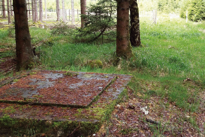
Fig. 7. No water flows at the surface from the captured Pekelský stream spring near Aš, which is enclosed in a chamber (photo: P. Eckhardt)
Another major intervention affecting the structure of springs in the study area was land drainage, introduced to increase agricultural yields, particularly on arable land. Subsurface and surface drainage systems in this area date from the 1960s and 1970s [23] (Fig. 8). Over the past 30 years in particular, arable land in this submontane area has increasingly been converted to meadows and pastures, and drainage has therefore largely lost its agricultural purpose. The landscape has undergone numerous changes since the drainage systems were constructed and now contains a mosaic of functional and degraded drainage systems [13]. On some level sites in the floodplains of small watercourses, particularly in the Rokytnice catchment, the old drainage systems are now completely non-functional. This has led to natural recovery and the return of these areas to near-natural wetlands or periodically flooded floodplains. At the same time, approximately one third of all spring areas mapped in the Aš area on both sides of the border in 2020–2022 occur on land drained by systematic subsurface drainage. These are therefore so-called ‘secondary spring areas’ formed where blocked or damaged pipes cause drainage water to emerge at the surface (Fig. 9). Perhaps surprisingly, these secondary spring areas can perform the same functions in the landscape as natural spring areas, although they may have certain disadvantages by comparison. These can include greater fluctuations in temperature over the course of the year, poorer and more variable water quality, or instability of the spring outlet itself. As blockages and other changes occur within damaged drainage pipes, the point at which water emerges may shift from place to place. This has been observed, for example, at the long-term monitored secondary spring area U stružky (Luz 67) (Fig. 9), where the manager of the Bystřina – Lužní stream National Nature Monument (Slavkovský les Protected Landscape Area) has confirmed that the subsurface drainage system has been blocked for many years. Nevertheless, in spring areas with a disturbed water regime, even these habitats are important components of the heterogeneous landscape structure. They provide refugia for temporary macrozoobenthic species and other animals and increase biodiversity within the study area. Tab. 1 presents basic information on the nine monitored spring areas, including their principal characteristics and relationship to drainage.
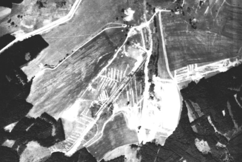
Fig. 8. Historical aerial photograph showing the construction of drainage systems around the village of Pastviny in the Aš area
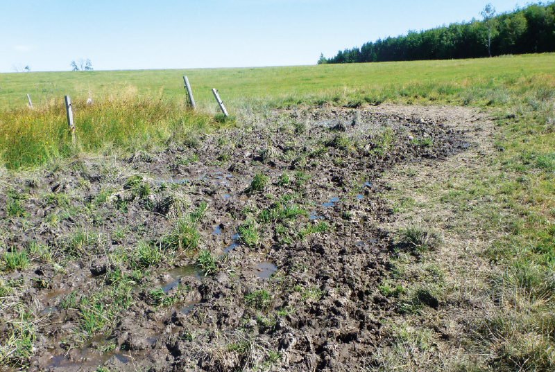
Fig. 9. Luz 67 spring area formed by a drainage-system failure in a pasture; previously fenced off, the secondary spring outlet has since shifted, and the wetland area is now repeatedly damaged by livestock (Aš area)
By contrast, where parts of the subsurface drainage systems remain functional, they continue to accelerate water runoff, reducing the landscape’s capacity to retain water and causing spring wetlands to dry out. In some cases, drainage systems continue to serve a useful purpose. For example, they are often retained around major linear infrastructure or infrastructure reconstructed in the recent past to prevent damage to these structures. In protected areas, or in catchments immediately adjacent to them, however, nature conservation interests should take precedence [24]. In spring areas, the quality of drinking water and the benefits of retaining water in the landscape likewise outweigh the benefits of maintaining agricultural land on sites that would otherwise be naturally waterlogged. Nevertheless, although the removal of systematic drainage is desirable in many places, it faces numerous administrative and practical obstacles, involves complex property ownership issues, is financially costly and requires not only project planning but also cooperation between several stakeholders.
In the forests of this area, surface drainage channels were constructed in the past to drain some spring areas and other wetlands locally (Fig. 10). They are most concentrated in the headwaters of the Lužní stream and in the Rokytnice catchment above Dolíška pond. These are generally simple excavated ditches leading from small forest spring areas to the nearest headwater stream, or sometimes into another ditch, forming a more or less functional drainage network. Some ditches carry water throughout the year, others only for part of the year, while some have now dried up completely. Straightened spring-fed channels lined with concrete slabs, such as those in the spring area of the Újezdský stream, also contribute to accelerated runoff and reduced infiltration. The present-day landscape of the Aš area is also changing as small historical ponds and pools, often situated in or along the edges of forests, gradually silt up and disappear naturally. These were constructed by the original German inhabitants of the area from the beginning of the modern period, but particularly during the 19th century. Interestingly, one reason for constructing these retention ponds was the seasonal fluctuation in streamflow during the summer months, which had already been observed in the Aš area at that time, and the need to maintain a reliable water supply for mills, sawmills and the first ironworks, and later for paper mills and the textile industry [23].
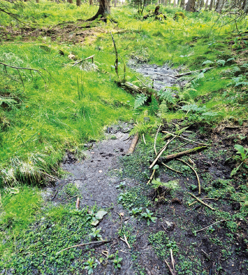
Fig. 10. One of the upper spring outlets of the Lužní stream, dry in 2025; drainage channels located 20–50 m from the outlet convey water towards the Lužní stream, affecting the discharge and overall condition of the spring areas (Aš area)
Drainage of agricultural and forest land, whether through subsurface systems or surface drains, rapidly conveys water from spring areas into watercourses. In years with below-average precipitation, this contributes to the drying out of spring wetlands and, subsequently, small watercourses. In years with average or above-average precipitation, by contrast, accelerated runoff can contribute to flash flooding or lead to the formation of gullies and other forms of erosion. Since the designation of small-scale protected areas in the Aš area from the 1990s onwards, numerous restoration projects of varying scales have been conducted and land management practices have improved [14]. The most recent example is the restoration of a straightened and incised section of the Lužní stream near Pastviny [25]. Most restoration measures, however, have focused solely on watercourses, while spring areas and small headwater channels have been neglected for various reasons.
Blanice and Zlatý streams catchment study area
The upper catchments of the Blanice and Zlatý stream in the Šumava region are important headwater areas. In addition to well-known springs and wells that have historically been used by local people, hundreds of natural and near-natural spring areas have been mapped here in several phases associated with different projects from 2005 to the present. From a hydrogeological perspective, the study area lies within Hydrogeological Region 6310 – Crystalline Basement in the Upper Vltava and Úhlava Catchments, and Groundwater Body 63101 – Crystalline Basement in the Upper Vltava and Úhlava Catchments [15]. Hydrologically, some of these spring areas lie within the catchments of the Spálenecký, Sněženský and Tetřívčí streams and the upper Blanice itself, while others lie within the Luční and Zlatý stream catchments. The Zlatý stream is also a tributary of the Blanice downstream of Husinec Reservoir.
Development of springs in the Blanice study area
Historically, small watercourses flowing from springs in the Křišťanov, Arnoštov and Boletice areas were used for gold panning from as early as the 14th century, as was the Blanice itself. Later, under Schwarzenberg administration, timber harvesting expanded considerably in the catchment. Transporting the timber required modifications to the hydrographic network, including the construction of log-driving reservoirs (splash dams), which were used to increase water levels artificially. Most have since disappeared, although some still exist, including Puchárenský pond. Springtime timber floating continued until the beginning of the 20th century. As in other areas, water was also used to power mills and ironworks.
This area is unique within the Czech Republic in that, although agriculture and forestry were intensified here between 1970 and 1990, accompanied by efforts to drain land extensively for agricultural use, it was relatively little affected by drainage schemes [26, 27] (Fig. 11). This may have been because the area was not targeted until the late 1980s. Systematic subsurface drainage systems were constructed, for example, in the catchments of the Vyšenský, Zbytinský, Magdalenský and Kukaččí streams within the Blanice catchment, and in the Luční and Zlatý stream catchments in the neighbouring area. Some catchments remain unaffected by large-scale drainage, including those of the Hornosněženský, Tetřívčí and Spálenecký streams, as well as other small watercourses within the Boletice Military Training Area (Fig. 12). In these catchments, therefore, the capacity of natural spring areas to retain water in the landscape, maintain local biodiversity and potentially provide other ecosystem services can be readily compared, on a larger scale than in the Aš region, with the limited functionality of secondary spring areas. Although, after 1990, arable land in the Blanice National Nature Monument and the Prameniště Blanice National Nature Monument was converted to grassland and extensive management was introduced, significantly improving water quality [28], the historical large-scale drainage itself is still regarded as an irreversible adverse intervention, with the deteriorating drainage systems continuing to have a negative impact on the landscape water regime.
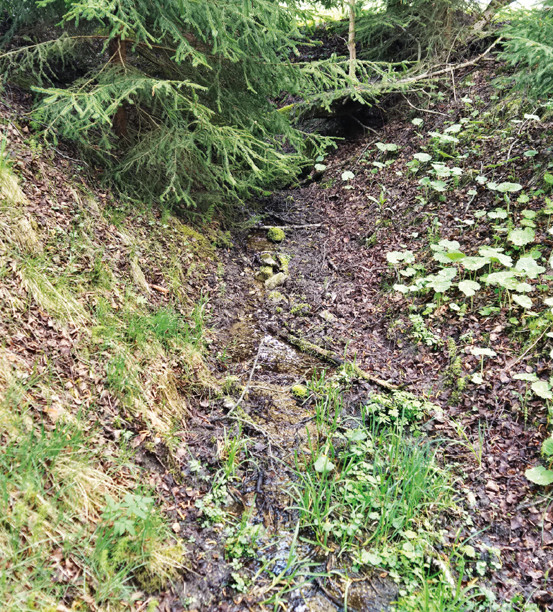
Fig. 11. VMP08 spring area drained by a drainage channel (upper Blanice catchment area)
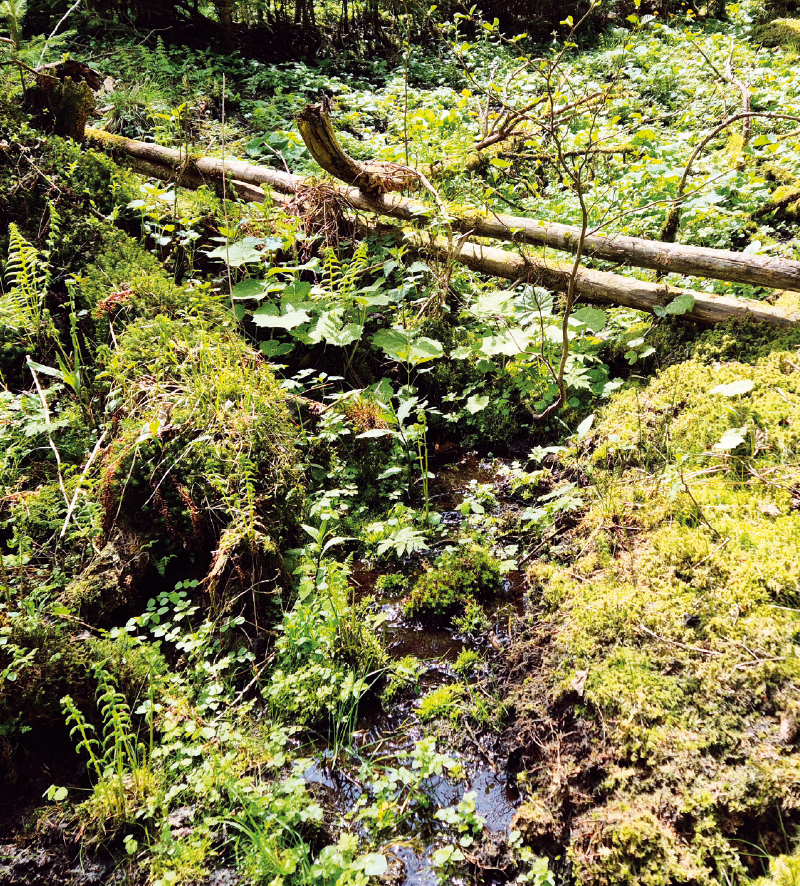
Fig. 12. Natural forest spring area M01A (upper Blanice catchment area)
For comparison, we identified the basic characteristics of 14 spring areas in the Blanice and Zlatý stream catchments and their relationship to drainage. An overview is provided in Tab. 1.
Comparison of water quality in natural and restored spring areas in the Aš and Blanice study areas
The comparison of changes in water quality between natural and drained spring areas revealed several interesting patterns within this limited sample. While some natural spring areas showed slight improvements and others slight deterioration, the overall mean score for all undrained spring areas (0.42 points) indicated that water quality at these outlets was relatively stable. No differences were observed between the catchments (Aš versus Blanice/Zlatý stream). The scores for spring areas affected by drainage showed a different pattern. No deterioration was recorded; water quality at these outlets had either remained unchanged or improved since the initial sampling in 2005–2009 (mean score 2.22 points). Relatively marked improvements in two or three parameters were recorded, for example, at three spring areas in the Aš area. Two of these are secondary spring areas formed as a result of failures in drainage systems (Luz 67 – U stružky and Bys 04 – U hlásky), while the third is drained by a deepened ditch (Luz 23 – Bílý vývěr).
DISCUSSION
Of the three impacts investigated, spring capture for public drinking-water supply proved fatal to the very existence of surface spring outlets. This was the case both in the Hřensko study area (Pod Pravčickou bránou spring, Pytlův spring and the main outlet of Nad Klepáčem spring) and in the Aš area (e.g. Pekelský stream spring). Intensive groundwater abstraction near Hřensko also resulted in the disappearance of Panenský spring and a decline in the discharge of some of the surrounding springs.
By contrast, the large-scale fire around Hřensko did not result in significant long-term changes in either the quantity or chemical composition of water from the major springs monitored within this hydrogeological structure. Some short-term adverse changes were nevertheless observed. A marked decrease in groundwater pH after the fire was recorded in the Mezná abstraction area, although this area does not abstract water from springs. Following the deterioration of some groundwater parameters after the fire, individual hydrochemical parameters returned to their usual long-term levels within several months to one year. The forest fire therefore had only a minor effect on groundwater quality, unlike some fires at industrial sites [19].
Land drainage and the shortening and straightening of watercourses in the Aš area have accelerated runoff from the catchments. Together with the capture of some springs, particularly in the Pekelský stream area, this causes significant problems during periods of drought. Changes in the landscape water regime, combined with climate change, are resulting in more frequent hydrological extremes – floods and droughts – which increasingly disrupt the normal functioning of human society and also have a major impact on aquatic and water-dependent organisms in the area. In the Blanice and Zlatý stream catchments, the smaller extent of land drainage means that, although flooding and the drying out of some surface springs also occur, there are currently no records of watercourses drying out.
The comparison of water quality in the spring areas shows that water quality improved in those affected by drainage, particularly in terms of nitrogen compounds. In contrast to sudden disturbances, such as the fire around Hřensko, gradual changes can therefore have a positive effect on water quality in spring areas. The observed improvement was probably largely due to changes in land management between 2005 and 2025 and the gradual natural recovery of areas affected by systematic drainage. All the secondary spring areas investigated are located either within small-scale protected areas or in their immediate vicinity. In the late 1990s and after 2000, most of the formerly intensively managed land in this area was converted to meadows or pastures, including the sites containing the monitored non-forest spring areas. While the effects of intensive management probably persisted during the first sampling period, when concentrations of nitrogen compounds were still elevated, by the second monitoring period these substances were below the detection limit in the secondary spring outlets. A second factor is the natural recovery of drained areas. As unmaintained subsurface drainage systems gradually deteriorate, secondary springs increasingly acquire near-natural characteristics, while their water quality improves through natural self-purification processes.
The gradual improvement in water quality observed at secondary spring areas in the Aš area and Šumava closely corresponds with the growing need to protect these small aquatic habitats. Although these spring areas developed secondarily as a result of failures in drainage systems, studies from other countries show that, despite their secondary origin, they can provide key ecosystem services [29, 30]. Protecting and supporting these naturally recovering spring outlets is all the more important because ongoing climate change is likely to expose springs to increasing anthropogenic pressure from widespread abstraction of water resources, potentially leading to further irreversible degradation of these sensitive habitats [6]. Assessment of water chemistry alone, however, is only a first step and one of many criteria. A comprehensive assessment of the success of natural recovery in spring areas must also take into account biological indicators, typically benthic macroinvertebrate and bryophyte communities [31]. Previous research indicates that the ecological recovery of wetland habitats may not proceed entirely linearly: the diversity of sensitive communities may temporarily decline or remain unchanged immediately after changes in habitat conditions before a demonstrable increase occurs [32–34]. For this reason, as part of the ongoing project No. SQ01010130, the hydrochemical data presented here will be further evaluated in conjunction with the results of detailed biological monitoring.
Springs contribute to biodiversity and help maintain water availability near the surface during dry periods. Their at least partial restoration would therefore be desirable, not only within the study areas.
For example, in Bohemian Switzerland National Park, where enhancing biodiversity and nature conservation should be a priority, some historical springs could be restored at suitable sites. Restoration could make use of overflow water from Nad Klepáčem spring and potentially some of the water from Pod Pravčickou bránou and Pytlův springs, provided that this water is not essential for the public water supply and that the work is carried out in accordance with the enhanced groundwater protection measures applying in the area. Carefully returning spring water to the surface would not only enhance biodiversity but could also reduce the risk of fire in this sensitive area of the national park. Finally, the heavily used hiking trail to Pravčická brána, which is currently dusty and runs alongside the road, could once again become a more pleasant environment for both nature and the many visitors to the area.
Similarly, returning at least some of the water from Pekelský stream spring in the Aš area to the surface could restore the border watercourse, improve natural conditions, enhance biodiversity, and provide some additional protection against fire on land on both sides of the border.
CONCLUSION
Springs are important landscape features that enhance local biodiversity and help maintain water availability in the landscape during dry periods. Research into spring areas in the three study areas showed that the most significant intervention is their direct technical capture for drinking-water supply, which results in the complete loss of surface spring outlets. Large-scale land drainage also has a significant impact, contributing to the drying out of small watercourses and wetlands during dry years and accelerating runoff from the landscape. By contrast, some sudden disturbances, such as the large-scale forest fire in the national park, have no significant long-term effect on either the hydrochemical status or the quantity of groundwater in deeper hydrogeological structures.
Longer-term monitoring confirmed that gradual changes have a positive effect on water quality, particularly by reducing concentrations of nitrogen compounds. Specifically, these changes include the transition to extensive land management and the natural recovery of areas resulting from the deterioration of old drainage systems, leading to the formation of more or less stable secondary spring areas. For future landscape management, the sensitive restoration of historical springs by returning surplus or overflow water to the surface would be desirable, for example in Bohemian Switzerland National Park and the Aš area. This would not only help enhance biodiversity but also provide more effective protection against fire in sensitive areas.
Acknowledgements
The work was funded by the Technology Agency of the Czech Republic under the Environment for Life 2 Programme, project No. SQ01010130. We would also like to thank the Czech Hydrometeorological Institute (CHMI) for making its spring-monitoring data freely available, and the Czech Geological Survey (Geofond) for access to its archive.
The Czech version of this article was peer-reviewed, the English version was translated from the Czech original by Environmental Translation Ltd.
