ABSTRACT
This article presents a comprehensive overview of the evolution of methodological approaches to groundwater balance assessment in Czechoslovakia and the Czech Republic from the 1960s to the present. It outlines the transition from a static evaluation of “exploitable reserves” toward a dynamic, process-based concept, emphasizing regular comparisons between actual water abstraction and natural groundwater resources. This shift includes the adoption of monthly assessment intervals and quantile characteristics of base flow, aligning with the requirements of both national legislation (especially Act no. 254/2001 Coll., the Water Act) and European directives on water protection.
The study highlights the institutional framework and the roles of key organizations – such as the Czech Hydrometeorological Institute (CHMI), river basin management authorities, and the T. G. Masaryk Water Research Institute – in groundwater monitoring and data interpretation. A particular focus is placed on hydrogeological zoning as a key tool for spatial and balance assessments, including its historical development and relation to groundwater body delineation under the EU Water Framework Directive.
The core of the analysis is dedicated to four Upper Cretaceous hydrogeological zones (HGR 4410, 4430, 4522, and 4523) that have been consistently assessed as balance-stressed between 2007 and 2023. Long-term comparisons of base flow and abstraction data indicate a convergence trend, primarily due to declining natural recharge under changing climatic conditions. In some zones (especially HGR 4522 and 4523), excessive abstraction has contributed to negative impacts on surface water bodies, including seasonal drying, prompting regulatory responses such as reduced abstraction limits, regime-based monitoring, and mitigation measures.
The article draws on results from several ongoing research projects funded by the Technology Agency of the Czech Republic (e.g., no. SS06010268, no. SQ01010176, no. S02030027, and no. SS01010208), focusing on drought impacts, and improved delineation of hydrogeological zones, groundwater-surface water interactions, groundwater resource enhancement, and vertical stratification in groundwater flow.
The findings underscore the importance of detailed hydrogeological knowledge, continuous monitoring, periodic review of abstraction limits, and method refinement. The study concludes by stressing the need to protect infiltration areas and adopt long-term sustainable groundwater management strategies in the face of climate change and increasing anthropogenic pressures.
INTRODUCTION
This article summarises the development of groundwater balance assessment in Czechoslovakia and the Czech Republic from the 1960s to the present. It focuses on changes in approaches to evaluating the usability and balance of groundwater resources, as well as the methodological foundations and institutional frameworks that have gradually evolved in response to new knowledge, legislative changes, and the requirements of practice and European Union directives.
The text documents the beginnings of groundwater balance assessment, which were closely linked to the activities of the specialised subcommittee for groundwater within the Commission for the Classification of Deposits, where emphasis was placed on determining the so-called utilisable reserves. However, these values often did not reflect the seasonal or long-term variability of the natural regime. A significant advance came with the introduction of abstraction records in the 1970s, which enabled the compilation of regular annual balances that became part of the state water management balance.
Since the 1990s, the methodology has approached the requirement for data comparability (i.e., the comparison of actual abstractions with resources for the same period), with detailed monthly balances becoming necessary in stressed areas. The 80% quantile of base flow has become a key parameter. The text describes the current form of water management balance according to the valid Water Act and associated implementing regulations. It distinguishes between hydrological and water management balance, outlines the roles of individual institutions (CHMI, river basin authorities, and TGM WRI), and explains the principles of recording abstractions, reporting procedures, and data categorisation.
A separate section is devoted to hydrogeological zoning as a fundamental tool for spatial division of groundwater. The text traces the development of zoning from the 1950s to its most recent version in 2005 [1], which brought it into alignment with groundwater bodies defined for the purposes of river basin management plans and EU legislation. Emphasis is placed on the criteria for zoning, the link to balance units, and the connection with delineated water bodies.
Research on balance assessment methods in recent decades has highlighted the need for a specific approach to certain hydrogeological environments and structures, for which established procedures based on standard hydrological methods and base flow calculations cannot be mechanically applied. These include Quaternary deposits closely linked to surface water, karst structures, deep basin collectors, regional drainage areas, and similar features.
The practical approach to balance assessment is demonstrated using four Upper Cretaceous HGR, which are often described as balance-stressed.
DEVELOPMENT OF METHODOLOGICAL APPROACHES
History of groundwater balance assessment
The two fundamental terms used in groundwater balance assessment are hydrological balance and water management balance.
Hydrological balance evaluates changes in surface and groundwater stocks caused by temporal and spatial variability of natural factors, particularly climatic influences, and provides a basis for assessing changes in water stocks resulting from water use or other anthropogenic interventions. Thus, hydrological balance concerns the determination of natural groundwater resources within the context of the entire hydrological cycle, including spatiotemporal variability of quantitative characteristics. At present, the magnitude of natural resources is significantly influenced not only by seasonal climate variability but also by long-term trends associated with ongoing climate change. Today, the calculation of hydrological balance is inconceivable without the use of various hydrological and hydraulic mathematical models.
Water management balance is the comparison of water abstraction demands with the magnitude of natural resources at a given location and time. In this way, water management balance provides an overview of the state of water resources, degree of utilisation, and potential for future increases. Comparison of natural resources and groundwater abstractions forms the basis for assessing the balance stress of a given area. Modern water management balance assessment relies on a set of advanced statistical analyses and procedures. The results of water management balance constitute a fundamental basis for water management planning and governance.
Hydrological and water management balances together form the so-called water balance, as defined by the Water Act [2].
The following provides an overview of the gradual development of groundwater balance assessment in Czech Republic:
- In the mid-1960s, a specialised subcommittee for groundwater was established as part of the Commission for the Classification of Mineral Deposits (KKZ). The principles of this commission were largely determinative for the field of groundwater as well (Guidelines for the Valuation of Groundwater Reserves and Principles for Submitting Reports: 1964, 1965, 1979). Values reported as utilisable reserves represented a heterogeneous set of results. These values were generally determined with varying degrees of reliability and often represented averages over non-uniform, sometimes undefined shorter or longer periods, and therefore could not capture either the long-term variability or the seasonal changes of the natural groundwater regime.
- The early 1970s were marked by efforts to compile regular water management balances at the level of the then-existing zones. From 1979 onwards, regular annual balances became available, facilitated in large part by the introduction of abstraction records under Decree no. 63/1975 Coll.
- From 1979 onwards, groundwater balance formed part of the state water management balance, in the form of a comparison between so-called utilisable reserves and actual abstractions for a given year. The method for calculating utilisable reserves was not uniform and did not account for temporal variability of groundwater resources; as a result, the outcome did not represent the actual balance status, but rather an average over the assessed period. The ratio of reserves to abstractions was calculated, and balance status was classified as passive (< 0.9), stressed (0.9–1.1), or favourable (> 1.1).
- Since 1994, water management balance methodology has shifted towards gradual assessment of base flows, which, from a hydrogeological perspective, can generally be equated with groundwater outflow over multi-year averages, and, by extension, with natural groundwater resources, with the regimes of both quantities considered either identical or at least very similar.
- The principles of modern groundwater balance assessment in recent decades, beginning in the 1990s, aim to capture the variability of natural groundwater resources and consistently distinguish long-term values from annual ones. The fundamental purpose of this new approach is to compare comparable values for both resources and abstractions, corresponding to the same time period. It is efficient to carry out the balance assessment in two phases. If the balance status of a zone is good or satisfactory, it is sufficient to limit the assessment to a comparison of annual values. In such cases, the balance is limited to a summary of current data on the size of resources and abstractions for a specific (completed) year, together with a comparison of resources against long-term values for selected representative periods. In zones where the ratio of resource size to abstractions indicates that a stressed or even passive state may occur, a more detailed assessment is necessary. Seasonal fluctuations in both resources and abstractions can be so significant that annual values do not provide an adequate basis, and it is therefore necessary to perform the balance in a monthly step.
- From 1997 onwards, the 80% quantile of the base flow exceedance curve for 1971–1990 was introduced as the fundamental calculation value for the balance (the reference period was gradually replaced by successive 30-year periods: 1971–2000, 1981–2010, and 1991–2020). This value represents the long-term utilisable resources for water management balance.
Current water management balance of groundwater
Monitoring and assessment of the status of surface and groundwater, in accordance with Section 21 of the Water Act [2], serve to provide the basis for the exercise of public administration under said Act, for water planning (Chapter IV, Water Act), and for the provision of information to the public. It is carried out according to surface water catchments and HGRs, or groundwater bodies, and includes, among other things, maintenance of water balance (Section 21(2)(b), Water Act) and establishment, management, and updating of records pursuant to Section 21(2)(c), Water Act. The data contained in these records form part of the Public Administration Information System – VODA [3].
Water balance consists of hydrological balance and water management balance. Hydrological balance compares water gains and losses and changes in water storage within a catchment, territory, or water body over a given time interval, and it is compiled by CHMI. Water management balance compares requirements for surface water abstractions, groundwater abstractions, and wastewater discharges with the available capacity of water resources in terms of quantity, quality, and ecological status (Section 22(1), Water Act). It is compiled, within their territorial jurisdiction, by the state-owned river basin authorities pursuant to Section 54 of the Water Act [2] and further in accordance with Section 5(3) of Decree No. 431/2001 Coll. [4]. Comprehensive annual and nationwide processing of water management balance data is carried out by TGM WRI [5].
For the purposes of water management balance, CHMI has always provided source-side data of the balances by determining baseflow on the basis of information from the national monitoring network, groundwater level observations, and strength of source. This indicator of natural groundwater resources is processed annually from current data of monitoring stations. To track development of these resources over longer periods, the value of natural resources derived from long-term monitoring is used (a 30-year period, currently 1991–2020). Therefore, balance assessment includes a comparison of abstractions both with the value of actual natural resources of the previous year and with the value of long-term natural resources. The requirements of the EU Water Framework Directive have been reflected in methodological procedures used by TGM WRI in agreement with MoE (Water Protection Department). Instead of calculating baseflow, comprehensive assessment of natural groundwater resources is now anticipated, since baseflow alone may not be determinative in some environments (groundwater bodies in close hydraulic connection with surface waters, karst areas, drainage areas composed of several hydrogeological aquifers, deep basin aquifers with long residence times, etc.). In such cases, it is particularly necessary to apply modern research methods, including isotope analyses and hydraulic modelling procedures.
It is not yet possible to determine the size of natural resources for all HGRs – either they are so affected by anthropogenic activity that determination is unrealistic, or data are not available in the required structure and detail, or methodological uncertainties persist (e.g., for Quaternary regions closely linked to a watercourse). The key characteristic expressing resource capacity of a hydrogeological structure is the value of the natural resource, usually expressed in l/s and related to the area of the assessed territory (generally an HGR) and the assessment period. Natural groundwater resources are determined for each month and year, as well as the average value over a given monitoring period. Values of natural resources are established by CHMI as part of hydrological balance.
For selected HGRs, the Czech Geological Survey carried out a detailed reassessment of natural resources in the project Rebalancing of Groundwater Reserves [6], conducted from 2011 to 2016. Advanced numerical hydrological and hydraulic models were used for rebalancing of natural resources (rebalancing because earlier balances existed with varying quality) with input data from archival research, drilling works, hydrological and borehole logging measurements, and other direct observations, and with retrospective verification against actual data. One of the outputs is value of utilisable groundwater, based on 90% security of natural resources, considering the requirement to maintain minimum residual flows in the river network while ensuring sufficient water availability for groundwater-dependent protected ecosystems.
Groundwater abstraction records
Under Section 29 of the Water Act [2], groundwater resources are primarily reserved for the supply of drinking water to the population and for purposes for which the use of drinking water is prescribed by Act no. 258/2000 Coll. [7]. Groundwater may be used for other purposes provided that such use does not compromise the needs mentioned above.
For the purposes of the water management balance under Section 22 of the Water Act [2], groundwater users holding a permit to abstract groundwater in amounts exceeding 1,000 m³ per calendar year or 100 m³ per calendar month (limits effective from 2022) are required to report annually to the relevant river basin authorities the quantities of groundwater abstracted (as set out in Section 10 of the Act). The scope of these reported data and the procedure for reporting to the relevant river basin authority are defined in Sections 10 and 11 of Decree No. 431/2001 Coll. [4]. In the assessment of groundwater quantity and quality, in accordance with Decree No. 393/2010 Coll. [8], abstractions exceeding 6,000 m³ per calendar year or 500 m³ per calendar month are included in the balance.
Hydrogeological zoning
The basic unit of groundwater balance is HGR. It is an area with similar hydrogeological conditions, type of aquifer, and groundwater flow, composed of one or more groundwater bodies.
Zones are delineated based on natural characteristics in the upper, main, and deep layers.
- The beginnings of groundwater zoning can be traced to the 1950s, with the first zoning approved in 1965 as part of early stages of water management planning.
- A more detailed zoning was introduced in the 1972 Master Water Management Plan (Fig. 1) [9].
- The revised zoning in 1986 [10] was already used as a territorial element of the national water management balance. In this revision, previously predominant geological and hydrogeological criteria were consistently complemented by a hydrological concept, so that the zones met, as far as possible, the condition of a hydrologically closed balance unit, in which all phases of groundwater flow (recharge, movement, storage, and drainage) were clearly defined. A total of 105 HGRs were delineated [10].
- The final version of hydrogeological zoning was prepared in 2005 (Fig. 2) [11] and remains valid to the present day. The updated zones correspond closely to the delineated groundwater bodies. Within this zoning, 152 HGRs are identified in Czech Republic: 111 in the main layer, which covers the entire country; three zones in the basal Cretaceous aquifer (in the north-western part of the Bohemian Cretaceous Basin); and 38 zones in the upper layer (Quaternary and Neogene sediments, Jizera Coniacian). Groundwater abstractions are assigned to these zones taking into account the type of hydrogeological structure (e.g., basin structures, hydrogeological massif, karst, flysch, Quaternary, Neogene). HGRs generally correspond to the delineation of groundwater bodies used for river basin management plans and are clearly assigned to individual river basins. This means that HGRs are always assessed as a whole, even if administrative boundaries would suggest they should be divided. The exceptions are HGR 6320 (Upper Vltava/Lower Vltava) and HGR 2250 (Morava/Dyje), which are divided between two sub-catchments according to the four groundwater bodies delineated within them. Two groundwater bodies fall into one sub-catchment and the other two into the second. This ensures that groundwater assessment for river basin management plans and the water management balance is always carried out for the entire sub-catchment as a whole.
- Following the new hydrogeological zoning, Decree No. 393/2010 Coll. [8] was issued by the Ministry of Agriculture (MoA), which, among other things, updates the assignment of individual HGRs to the corresponding sub-catchments. At the same time, a new decree was issued jointly by the Ministry of the Environment (MoE) and MoA, Decree No. 5/2011 Coll. [1].
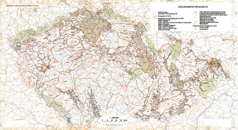
Fig. 1. Hydrogeological zones 1972 [9]
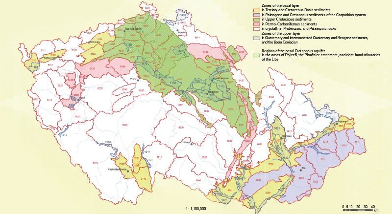
Fig. 2. Hydrogeological zones 2005 [11]
Procedure for calculating water management balance
Groundwater management balance is based on a standard procedure – determining the ratio of groundwater abstractions to natural resources in a defined territory and period. The size of natural resources represents the natural dynamic component of groundwater, expressed in volumetric units over time (l/s), and is generally determined in practice by the variable magnitude of baseflow. Baseflow magnitude of is determined as part of the outputs of the hydrological balance of water quantity at CHMI, where specific values are calculated for individual HGRs based on measurements. HGR is the basic balance unit for assessing groundwater quantity and includes one or several usually closed hydrogeological structures. In other cases as well (e.g., regional hydrogeological surveys from the 1960s to 1980s or the Rebalancing of Groundwater Reserves project), natural resource data were always collected within HGRs; therefore, more detailed data for smaller areas are generally not available.
Baseflow calculation (CHMI) is derived from total flow on a daily basis using the separation method according to Eckhardt. The recession coefficient is determined from an analysis of flow recession curves. The ratio of total to baseflow, BFImax, is calibrated to match the course of total and baseflow during the falling limbs of the hydrograph. Static groundwater reserves are determined from the Boussinesq equation, which relates storage to baseflow.
Groundwater management balance is processed annually, currently for approximately 102 HGRs (for 2023) out of a total of 152, covering just under 81 % of the area of Czech Republic (Fig. 3). The reason for not calculating baseflow in Quaternary sediments is the lack of input data and often the complex assessment of resources in these types of HGR, where both the influence of surface water and drainage of deeper hydrogeological structures are evident. Due to ongoing methodological uncertainties and the incomparability of the obtained values, balance assessment for these HGRs has not yet been carried out for the purposes of water management balance.
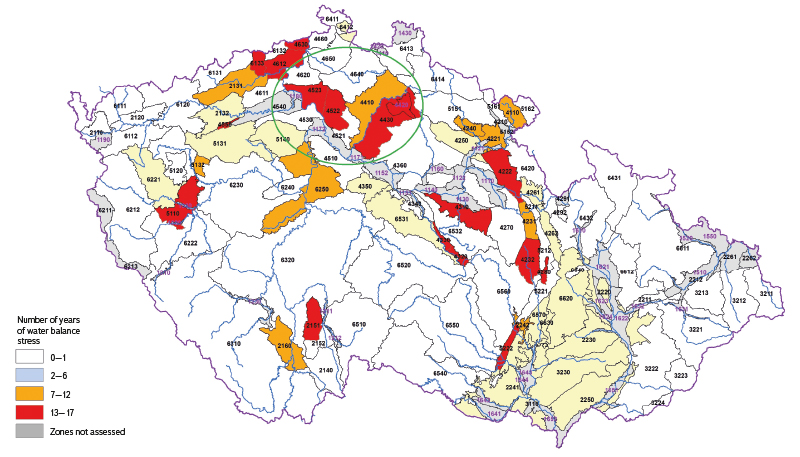
Fig. 3. Assessment of balance stress of HGR base and upper layers for 2007–2023; HGR areas discussed in the following section are shown in green
In the balance of groundwater quantity, total abstractions are compared with values of natural groundwater resources within the spatial unit (HGR, see Fig. 3). As a precautionary measure, TGM WRI, in agreement with the MoE (Water Protection Department) and the MoA (Water Management Department), adopted a methodological approach in which zones are assessed by the ratio of maximum monthly abstraction in a given year to minimum monthly baseflow in the same year (MAX/MIN) [12–14]. This thus identifies the potentially most unfavourable state within the assessed year. If the MAX/MIN ratio exceeds 0.5, the zones are considered balance-stressed, and further assessment in a monthly step is required, comparing monthly baseflow values with actual monthly abstractions. If balance stress is confirmed by the analysis of monthly data, a detailed hydrogeological assessment of the zone should follow, including a groundwater flow hydraulic model, to determine the actual situation, identify the problem, and explore possible remediation measures. An interesting question could be how balance stress of zones would appear if permitted abstractions were used instead of actual abstractions; however, this is beyond the scope of this article.
RESULT: EXAMPLES OF BALANCE ASSESSMENT IN HYDROGEOLOGICAL ZONES OF THE BOHEMIAN CRETACEOUS BASIN
Fig. 3 shows the area from which four HGRs of the Bohemian Cretaceous Basin were selected as examples of the applied procedures; these HGRs are regularly reported as balance-stressed. Currently, the HGRs with regularly reported balance stress 4522, 4410, and 4430 are part of applied research funded by TA CR (projects no. SS06010268 Understanding, Quantification, and Protection of Strategic Deep-Circulation Groundwater Resources of the Bohemian Cretaceous Basin in HGRs 4410 and 4522 and no. SQ01010176 Impacts of Climate Change on Minimum Residual Flows in the Jizera River Network and on Groundwater Abstractions Near the River). Due to spatial continuity, the neighbouring HGR 4523, which is also reported as stressed, was included in the assessment for the purposes of this article.
Key results are expected primarily from project no. SS06010268, which aims to improve understanding of the hydrogeological basin environment of the Upper Cretaceous sediments and, among other objectives, to determine whether the regularly observed balance stress might also be related to incorrect delineation of current zone boundaries, which may not fully characterise closed hydrogeological structures. There are already strong indications (tritium analyses, residence time calculations, tracer results using CFC/SF6, and a conceptual groundwater flow model [15, 16]) that call for a new perspective on groundwater flow directions at the interface of HGR 4522, 4410, 4521, and 4640. If these new perspectives are confirmed, the research results could also be reflected in the assessment of balance stress in these areas.
To illustrate the results achieved in water management balance assessment, four HGRs were used:
- HGR 4410 Cretaceous of the Jizera River, right-bank part
- HGR 4430 Cretaceous of the Jizera River, left-bank part
- HGR 4522 Cretaceous of the Liběchovka and Pšovka Streams
- HGR 4523 Cretaceous of the Obrtka and Úštěcký potok Streams
The selected HGRs have long been classified as balance-stressed (Fig. 3), noting that this assessment considers the most unfavourable condition within a given year (i.e., the ratio of maximum monthly abstraction to minimum monthly baseflow exceeds 0.5). This serves as an initial signal that, when a region is flagged as stressed, further evaluation in a monthly step is required to reveal the distribution of these indicators over the entire period. HGR 4410 has been classified as stressed regularly since 2016, HGR 4430 since 2012, and HGRs 4522 and 4523 since 2007 and 2008, respectively.
The named HGRs were therefore assessed with respect to natural groundwater resources and abstractions for the period 2007–2023. The assessment first compared maximum monthly abstraction with minimum monthly baseflow alongside long-term baseflow values (1971–2000, 1981–2010, and 1991–2020) and then compared monthly baseflow with actual monthly abstractions over 2007–2023.
HGR 4410 Cretaceous of the Jizera River, right-bank part
The area contains two separate hydrogeological Cretaceous aquifers. Basal aquifer A (which is part of two deep-layer HGRs – HGR 4710 Basal Cretaceous aquifer on the Jizera and HGR 4720 Basal Cretaceous aquifer from Hamr to the Elbe) is hosted in Cenomanian-age siltstones and sandstones, whereas aquifer C (forming the main part of HGR 4410 in the main layer) is hosted in Turonian-age sandstones and siltstones. The claystone sequence at the base of the Lower Turonian acts as a hydrogeological confining layer between the two aquifers and, by extension, between the HGRs. The main source of groundwater for water supply abstractions in HGR 4410 is the sandstones of the Jizera Formation, serving as Hydrogeological aquifer C. Part of the area is overlain by an artesian cover of Coniacian claystones [10]. Groundwater recharge occurs partly within the area of the HGR and partly via lateral inflow from adjacent HGRs, or through inflow from the Jizera River. It is clear that the largest abstractions from HGR 4410, in the Kochánky catchment, are in close hydraulic connection with the Jizera River (abstractions from the Quaternary sediments of the Jizera, which form part of HGR 4410). Abstractions in the Bělá and Strenický Stream catchments may be associated with lateral groundwater inflows from outside HGR 4410.
Fig. 4 shows that annual abstraction values remain consistently below natural resource values, or baseflow, which also holds for comparison of maximum monthly abstraction and minimum monthly baseflow. However, the MAX/MIN ratio criterion of 0.5 is regularly exceeded, and the HGR is therefore repeatedly classified as balance-stressed. Since 2014, a gradual convergence of the two values can be observed, primarily due to declining natural resources while abstraction volumes have remained constant (the MAX/MIN ratio is gradually increasing). A clear decline (about 20 %) is also evident in the consecutive 30-year averages of natural resources (1971–2000, 1981–2010, 1991–2020), undoubtedly reflecting the impacts of climate change. Comparison of baseflow and monthly abstraction values (Fig. 5) shows that abstractions remain consistently below baseflow in the monthly view, yet often represent more than 50 % of natural resources (baseflow); classification of the HGR as balance-stressed is therefore justified according to the applied methodology.
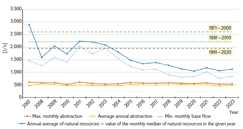
Fig. 4. Annual characteristics for basic balance assessment of HGR 4410, including long-term reference periods 1971–2000, 1981–2010, and 1991–2020
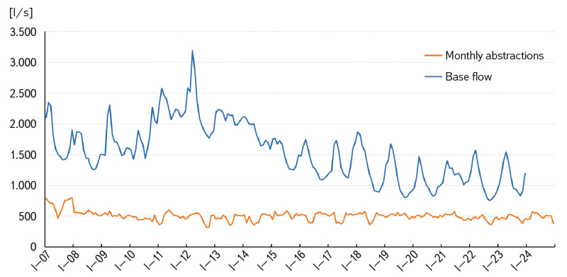
Fig. 5. Water management balance in a monthly step, 2007–2023 [17, 18]
4430 Cretaceous of the Jizera River, left-bank part
Three separate hydrogeological Cretaceous aquifers have developed in the area [10]:
- Basal aquifer A in Cenomanian psammites and aleurites (forming a separate HGR 4710 of the deep layer – Basal Cretaceous aquifer on the Jizera),
- intermediate aquifer C associated with Turonian psammites, divided by insulating layers into two main sub-aquifers, which further splits and wedges eastwards (forming the target aquifer of the 4430 main layer) and further east transitions into hydrogeologically unproductive Elbe Cretaceous with clayey development (HGR 4360),
- upper aquifer D associated with Coniacian psammites, forming a separate aquifer of the upper layer 4420, occurring over part of the 4430 aquifer area.
HGR 4430 is largely overlain by an artesian cover of Coniacian aleurites. Recharge of groundwater via direct infiltration within the area of the HGR is very limited; the majority is indirect, mediated by inflow from HGRs 4420 and 4410, or by inflow from the Jizera River, especially at abstraction points. It is indisputable that the largest abstractions from HGR 4430, in Benátky nad Jizerou (from the Quaternary deposits of the Jizera), are in significant hydraulic connection with the Jizera River. Hydraulic connection with surface waters can also be expected for other, smaller abstractions across the HGR.
Fig. 6 shows that annual values of average abstractions remain consistently below the values of average natural resources, i.e., baseflow. However, the MAX/MIN criterion of 0.5 is regularly exceeded, so the HGR is consistently classified as balance-stressed. Since 2014, a pronounced convergence of the two values can also be observed, primarily due to declining natural resources while abstraction volumes remain constant (the MAX/MIN ratio gradually increases). Comparison of monthly values (Fig. 7) of abstractions and baseflow shows that abstractions occasionally exceed natural resource values and, especially after 2015, this long-term unsustainable situation has become the norm. The impact of the prolonged drought period 2015–2019 is also evident, as the most recent 30-year average of natural resources (1991–2020) is the lowest (up to 27 % below the 1971–2020
range), compared with the previous two periods (1971–2000, 1981–2010),
clearly demonstrating the long-term effects of climate change.
 Fig. 6. Annual characteristics for basic balance assessment of HGR 4430, including long-term reference periods 1971–2000, 1981–2010, and 1991–2020
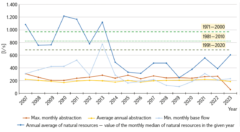
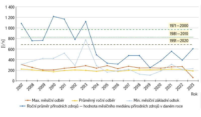
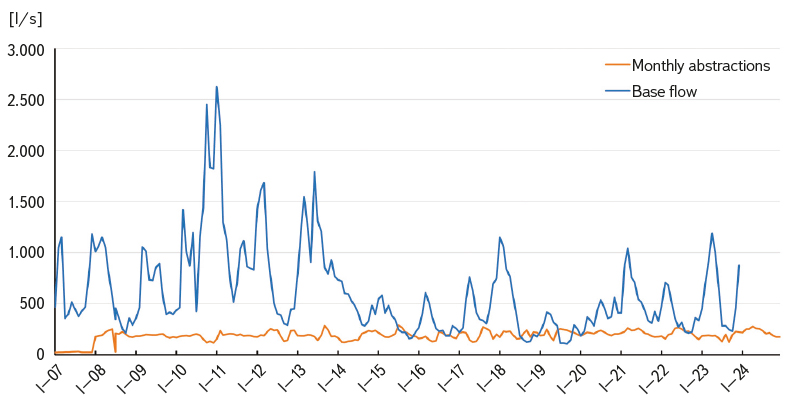
Fig. 7. Water management balance in a monthly step, 2007–2024 [17, 18]
4522 Cretaceous of the Liběchovka and Pšovka Streams and 4523 Cretaceous of the Obrtka and Úštěcký potok Streams
Both HGR encompass the area of right-bank tributaries of the Elbe River from Mělník to Litoměřice, where the catchments of the Pšovka, Liběchovka, Obrtka, and Úštěcký potok Streams experience significant drainage of the Cretaceous Basin sediments (key infiltration areas partly lie outside these HGR) and where very substantial water-supply abstractions take place. The area contains two main hydrogeological aquifers: basal aquifer A, associated with Cenomanian psammites and psephites (forming part of the deep-layer hydrogeological aquifer 4720 Basal aquifer from Hamr to the Elbe River), and aquifer C, associated with Turonian sediments of the Jizera Formation, which forms the HGR 4522 and 4523 discussed here. The Quaternary aquifer is hydraulically connected to aquifer C and cannot be separately delineated or assessed; it is therefore considered part of both HGR 4522 and 4523 [10]. Significant groundwater abstractions occur here from the Řepínský důl, Zahájí, Mělnická Vrutice catchments, and other sources.
It is evident from Fig. 8 that the annual values of average abstractions in HGR 4522 are mostly higher than the values of natural resources, or baseflow. When comparing the maximum monthly abstraction with minimum monthly baseflow, this difference becomes even more pronounced and persists throughout almost the entire assessment period 2007–2023. Since 2018, the gap between natural resources and abstractions has further increased, mainly due to a slight decline in natural resources while abstraction volumes have remained relatively constant. The MAX/MIN ratio criterion of 0.5 is thus regularly exceeded (reaching values above 1), so the district is justifiably classified as balance-stressed on a regular basis. The impact of the 2015–2019 drought period is also clearly visible, resulting in the lowest 30-year average of natural resources for 1991–2020 compared with the two preceding periods (1971–2000, 1981–2010), with a reduction of up to 24 % relative to 1971–2020, undoubtedly reflecting the long-term effects of climate change. Comparison of monthly values of baseflow and abstractions (Fig. 9) shows that until around 2015 the situation was relatively more favourable (abstractions were mostly below baseflow values, although even then they exceeded 50 % of baseflow). From approximately 2018 onwards, however, monthly abstractions consistently exceed baseflow values, representing a long-term unacceptable condition that should manifest in declining groundwater levels and static reserves (so called overexploitation of the hydrogeological structure).
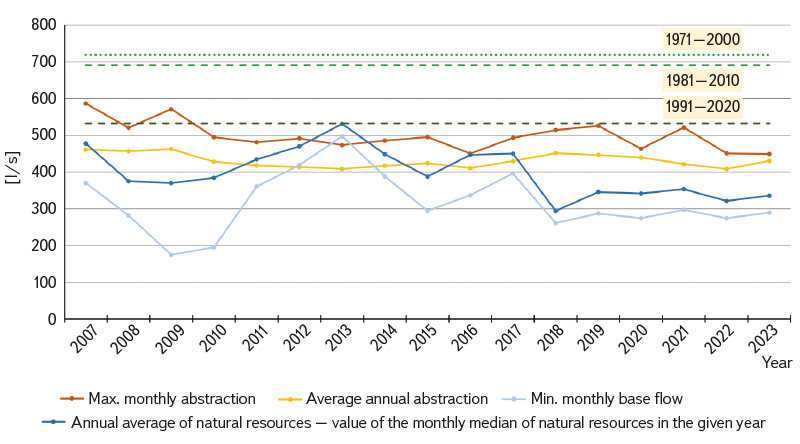
Fig. 8. Annual characteristics for basic balance assessment of HGR 4522, including long-term reference periods 1971–2000, 1981–2010, and 1991–2020
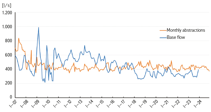
Fig. 9. Water management balance in a monthly step, 2007–2024 [17, 18]
Fig. 10 shows the state of water balance stress in HGR 4523. The situation here is a bit more favourable. Abstractions are mostly lower than the values of the annual average of natural resources, but from around 2015 the abstraction and natural resource values have approached each other significantly, mainly due to a decline in natural resources. Thanks to the current decrease in abstractions, the values have not yet exceeded natural resources. However, the MAX/MIN ratio criterion of 0.5 is regularly and consistently exceeded, and the district is therefore correctly classified as balance-stressed. A clear and very pronounced decline is also evident in successive 30-year averages of natural resources (1971–2000, 1981–2010, 1991–2020), reaching up to 37 % over the period 1971–2020, undoubtedly reflecting the impacts of climate change. Comparison of monthly baseflow and abstraction values (Fig. 11) indicates a more favourable situation; for most of the assessment period, monthly abstractions remain below monthly natural resource values (if the fluctuating baseflow values of 2009–2011 are disregarded, the opposite occurred only in 2018, and in recent years the situation has improved further due to a decline in recorded abstractions). The MAX/MIN ratio criterion of 0.5 is exceeded only rarely from the perspective of monthly values. From a methodological point of view, this demonstrates the great utility of assessing balance stress in a monthly step.
Fig. 10. Annual characteristics for basic balance assessment of HGR 4523, including long-term characteristic periods 1971–2000, 1981–2010, and 1991–2020
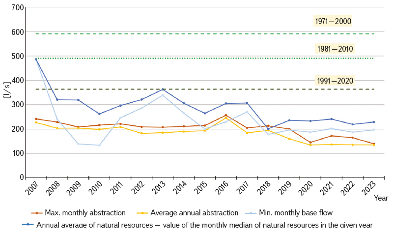
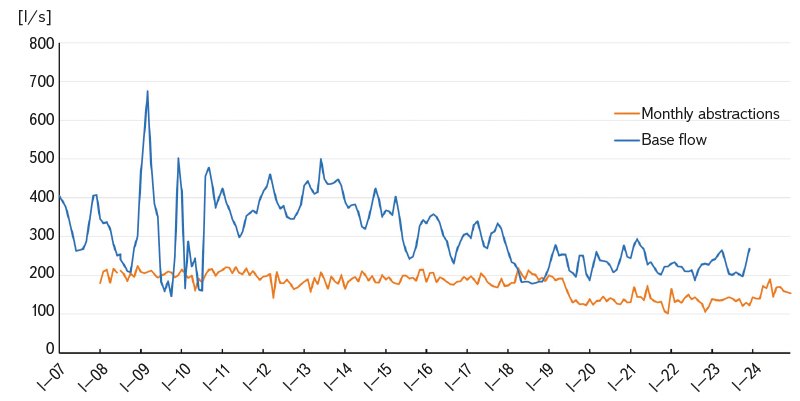
Fig. 11. Processing of water management balance in a monthly step – period 2007–2024 [17, 18]
DISCUSSION OF RESULTS
Hydrogeological zone 4410
Total abstractions from HGR 4410 have not caused regional declines in groundwater levels or reductions in static reserves. Its classification as a balance-stressed HGR (Fig. 3) is, however, justified by frequent exceedances of MAX/MIN criterion (Fig. 4), including after balance analysis in a monthly step (Fig. 5). Balance stress may occur locally, particularly in areas with large abstractions. It should also be noted that the difference between natural resources and abstractions is gradually decreasing, both on an annual and a monthly basis (see also progressively declining 30-year averages of natural resources), which, in connection with the impacts of climate change, raises some concern about a further increase in balance stress in the future. However, where certain abstractions from the Bělá and Strenický Streams are largely fed by groundwater originating from more distant recharge areas with longer residence times [16], the impacts of climate change on these abstractions can be expected to be considerably smaller.
From the perspective of protecting the groundwater resources of HGR 4410, we recommend that any future large abstractions be approved only after careful consideration of the available groundwater resources and their origin. Climate change will undoubtedly limit shallow-circulation resources. However, deeper groundwater flow with longer residence times (particularly from the west to northwest from HGR 4640), which is considerably more resilient to the impacts of climate change, offers significant potential for utilisation of these less vulnerable groundwater resources, whose quantification is also being addressed by the currently ongoing TA CR project no. SS06010268 [15]. In protecting the recharge of this deeper groundwater flow, the protection of infiltration areas is essential, particularly those at higher altitudes and with higher precipitation totals. Given the presence of the Jizera River and some other watercourses, there is also a certain potential in this HGR to increase groundwater resources through the application of managed aquifer recharge methods [19].
Hydrogeological zone 4430
Total abstractions from HGR 4430 have not yet caused regional declines in groundwater levels or reductions in static reserves; however, its classification among balance-stressed HGRs (Fig. 3) is fully justified due to frequent exceedances of the MAX/MIN criterion (Fig. 6), even after balance analysis in a monthly step (Fig. 7). Especially since 2014, abstraction values and natural resources have become very close, primarily as a result of declining natural resources due to climate change. Even after balance analysis in a monthly step (Fig. 7), it is evident that the two curves are close to each other, and there are even months in which total abstractions exceed baseflow values (the MAX/MIN ratio thus exceeds 1). It is also important to note the sharply declining 30-year averages of natural resources (by 27 % over the period 1971–2020), which – considering the impacts of climate change – raises further concerns for the future. These could result in either managed or unmanaged reductions in abstractions, or in abstractions being carried out at the expense of surface flows (the Jizera River and its tributaries).
From the perspective of protecting groundwater resources in HGR 4430, it should be noted that further available resources are relatively limited. In the future, any additional large abstractions should be permitted only after careful consideration of the local situation and balance stress. Relatively higher yields may be provided by sources relying on induced inflows from nearby surface streams (the Jizera River and its tributaries); however, during prolonged droughts, this could have adverse effects on streamflow characteristics and the ecological functions of these watercourses. For the protection of groundwater recharge in HGR 4430, it is essential to safeguard infiltration areas in HGR 4420 Jizera Coniacian and to consider abstraction volumes in the neighbouring HGR 4410 and 4420; a substantial increase in these abstractions would reduce the inflows from these zones into HGR 4430. It is therefore recommended, from a water balance perspective, that these three HGR be assessed together. Given the presence of the Jizera River and other watercourses, there is also some potential in this HGR to increase groundwater resources through the application of managed aquifer recharge methods [19].
Hydrogeological zones 4522 and 4523
It appears that the Cretaceous formations of the right-bank tributaries of the Elbe are an area where significant groundwater abstractions, combined with pronounced effects of climate change, result in actual water balance stress or a serious threat thereof. Observed phenomena include losses of water from surface streams (meaning that abstractions are effectively carried out at the expense of groundwater discharge to surface flow), and in some cases abstractions even actively induce a loss of surface water from the stream due to bank infiltration, all of which affect flow characteristics and minimum residual flows. A negative impact has been recorded on the lower course of the Pšovka (due to complex groundwater flow conditions), where part of the stream dries out during summer months over extended periods. Impacts have also been observed on some other streams (the Obrtka).
The situation has been closely monitored over the long term, and various measures have been implemented. Based on the Lower Elbe River Basin Management Plan (measures sheets), numerous studies have been carried out, and a series of joint meetings and hydrogeological surveys have taken place. From all these findings, the need for remedial and protective measures has emerged, including a reduction in groundwater abstractions (see reduction in abstractions after 2019 in Fig. 11). At present, the water supply operator holds a permit for groundwater abstraction from the Řepínský důl, Zahájí, and Mělnická Vrutice sites, amounting to 370 l/s, in which the maximum allowable abstraction at this site has already been significantly reduced. Within the Mělnická Vrutice catchment, regime monitoring is carried out with detailed evaluation. Monitoring results indicate that use of the Pšovka catchment is close to 100 % of current natural groundwater resources.
HGR 4522 is classified as highly stressed in terms of water balance, and this must be considered when permitting further groundwater abstractions within this HGR, especially in view of the anticipated deepening impacts of climate change on water conditions. For HGR 4523, the situation is only slightly more favourable. However, it shows the greatest decline in natural resources over the period 1971–2020 of all four assessed HGRs – up to 37 %. This represents the fastest reduction in available natural resources, offering a rather pessimistic outlook for future water balance stress.
If research within TA CR project no. SS06010268 demonstrates that part of the groundwater resources originates from outside HGR 4522 [15, 16], this could reduce water balance stress in HGR 4522. Simultaneously, the conceptual model indicates the existence of separate groundwater flow in deeper Turonian sub-aquifers, which was identified as part of the Rebalancing Groundwater Resources project. In the future, it would therefore be logical to process water balance at the level of these sub-aquifers, as there appears to be a significant difference in balance stress among them. However, a legitimate question remains as to whether there will be sufficient relevant data to carry out such a detailed sub-aquifer balance.
From the perspective of protecting groundwater resources in HGR 4522 and 4523, it should be noted that additional available resources are fairly limited. In the future, further large abstractions should not be permitted, or only allowed after careful consideration of the situation, the state of local water balance stress, and verification of the age and origin of the water inflow. Climate change will undoubtedly limit shallow-circulation resources. Deeper groundwater flow with a longer residence time, which is significantly more resilient to the impacts of climate change, does, however, provide certain opportunities for the utilisation of these less vulnerable groundwater resources [15, 16]. In protecting the formation of groundwater in this deeper flow, it is crucial to safeguard the recharge areas (both the areas of the two HGRs of interest and of HGR 4640 with higher elevations and greater precipitation totals). Theoretically, there is also some potential in both HGRs to increase groundwater resources through the application of managed aquifer recharge methods [19]; however, these considerations are constrained by the limited availability of surface water sources and lower precipitation totals. In practice, the only significant water source for infiltration is the Elbe River, so the southern parts of both HGRs could be considered for discussions on this topic, which would, however, need to include considerations of water quality of the Elbe.
CONCLUSION
This text focuses on the long-term evaluation of water management balance in selected HGRs of the Czech Cretaceous Basin for the period 2007–2023, specifically HGR 4410 (Cretaceous of the Jizera River, right-bank part), HGR 4430 (Cretaceous of the Jizera River, left-bank part), HGR 4522 (Cretaceous of the Liběchovka and Pšovka Streams), and HGR 4523 (Cretaceous of the Obrtka and Úštěcký potok Streams). The aim of the article was to illustrate the methodology and to identify the degree of stress in these zones based on the comparison of monthly groundwater abstractions with the minimum monthly values of the baseflow, also in relation to long-term hydrological characteristics (periods 1971–2000, 1981–2010, 1991–2020).
The mentioned HGR are, in most cases, evaluated as stressed over the long term, indicating the need for more careful management of abstractions and protection of water resources. Particular attention is given to HGR 4522 and 4523, where excessive abstractions (occasionally even exceeding natural resource values) cause drying of surface watercourses during drought. These impacts have led to a revision of abstraction limits, implementation of routine monitoring, and adoption of remedial measures based on the results of environmental impact assessments (EIA).
The article is set within the context of ongoing applied research (TA CR projects no. SS02030027, SS06010268, SQ01010176, SS01010208), which aim to refine knowledge of the hydrogeological environment, including redefinition of the boundaries of individual HGR, detailed clarification of the interaction between surface and groundwater, and identification of drought impacts on groundwater resources. Existing indications (e.g., results of tritium and other tracer analyses, residence-time calculations, and conceptual groundwater flow models) suggest that the boundaries of HGR 4410 and 4522 may be incorrectly delineated with respect to actual hydrogeological watersheds [15, 16], which could affect both the interpretation of balance results and planning of groundwater resource management. If partial sub-aquifers with distinct groundwater flow characteristics are identified within the previously assumed single hydrogeological aquifers, it is also a legitimate question whether separate groundwater balances should be carried out for each sub-aquifer. A combined balance encompassing several environments with mutually disconnected groundwater can distort the actual balance status. However, the actual implementation of separate balances for individual sub-aquifers depends on the availability of sufficient relevant input data. A balance analysis in a more detailed monthly step also proves to be very useful, as it provides a more precise view than the general annual analysis. If balance stress is confirmed at the monthly scale, a detailed hydrogeological assessment of the aquifer should follow from a professional perspective, including a hydraulic model of groundwater flow, in order to determine the actual situation, identify the problem, and explore possible remedies.
Overall, the text emphasises the need for a thorough understanding of the hydrogeological environment (optimally based on mathematical modelling of groundwater flow), the requirement for continuous monitoring, assessment, and potential revision of the overarching conditions for groundwater abstraction, with a focus on sustainable management and the long-term protection of water resources, as the negative impacts of climate change (reduced infiltration, declining water levels, and diminishing natural groundwater resources) are expected to become increasingly pronounced. Protecting groundwater quantity primarily means ensuring adequate protection of infiltration areas (which must first be reliably identified) and adopting a careful approach to managing groundwater abstractions, with a preference for abstractions intended for drinking-water supply (Section 29 of the Water Act [2]). The conclusions of the article provide important guidance for groundwater management, setting of abstraction permits, and overall strategic governance of water resources under conditions of climate change and increasing pressures on their use [20, 21].
To conclude, it is worth noting that the lower cost of groundwater (compared with surface water) also has a negative impact on management of groundwater resources. The price of surface water in Czech Republic is significantly higher than that of groundwater, which often leads to preferential – and in many places excessive and sometimes inappropriate – use of groundwater instead of surface water (for example, for purposes other than public water supply). Adjusting the price of groundwater abstraction could serve as a significant economic instrument for the protection of available groundwater resources. Revenue generated from higher abstraction fees, if reinvested into further exploratory and monitoring activities focused on capture and infiltration areas, would greatly contribute to improving knowledge of the hydrogeological environment and the long-term sustainable use and necessary protection of groundwater throughout Czech Republic.
Acknowledgements
The article was supported by the Technology Agency of the Czech Republic through the funding of research project no. SS02030027 Water Systems and Water Management in the Czech Republic under Climate Change Conditions (Water Centre), carried out in 2020–2026; project no. SS06010268 Understanding, Quantification and Protection of Strategic Deep-Circulation Groundwater Resources of the Czech Cretaceous Basin in HGRs 4410 and 4522, carried out in 2023–2026; project no. SQ01010176 Impacts of Climate Change on Minimum Residual Flows in the Jizera River Network and on Groundwater Abstractions in Its Vicinity, carried out in 2025–2028; and also within the implementation of results from project no. SS01010208 Managed Groundwater Recharge as a Tool to Mitigate the Impacts of Drought in the Czech Republic, carried out in 2020–2023.
The Czech version of this article was peer-reviewed, the English version was translated from the Czech original by Environmental Translation Ltd.
