ABSTRACT
Rainwater management is currently one of the frequently discussed topics in the further territorial development of towns and municipalities. The same question is also addressed in the context of climate change and its effect on already existing urban areas. Currently, the most common solution for the disposal of rainwater is its drainage using sewage systems. In connection with climate change, this concept of rainwater management is beginning to show its disadvantages. Rainwater is quickly drained away, which negatively affects moisture conditions in the urban landscape. The consequence of this is its drying and overheating. Another disadvantage is overloading of sewer networks during extreme rainfall events. The solution to eliminate these disadvantages can be an effort to retain the precipitation at the point of impact. However, this concept brings with it a number of questions: What measures can be used for this purpose? What are the spatial requirements for creating these measures? What is the price of their implementation? Can local government demand implementation of these measures by private investors? the answers to these questions are often not trivial and depend on the specific circumstances and the number of assessed criteria. Some help in this regard comes from the RainWaterManager software. This tool helps to choose appropriate measures for rainwater management, to estimate its effectiveness, spatial and economic requirements, and shows how their implementation can be promoted.
INTRODUCTION
In large cities around the world, various adaptation measures have been proposed for a long time, one of which is to improve rainwater management [1, 2]. The current concept still relies heavily on it being diverted from the point of impact. For this, unified or partitioned sewage systems are usually used. The shortcomings of this solution are overloading of sewer networks and the negative influence of moisture conditions at the point of precipitation impact [3]. Overloading of sewer networks occurs in particular in cases of extreme rainfall. Subsequently, the absence of moisture in the soil profile, caused by the rapid drainage of water, negatively affects urban greenery, reduces natural evaporation value, and thus contributes to the formation of heat islands and the overall deterioration of the urban microclimate. Due to the ever-increasing manifestations of climate change, it can be expected that the frequency of extreme precipitation totals and average temperatures will be increasing [4]. The answer to these problems could be a new system for rainwater management. The main philosophy of this system is the retention and use of rainwater at the point of impact. The promotion of these approaches in urban areas in the Czech Republic is currently at the stage of planning and implementation of initial projects. Due to the need to adapt to climate change, their application is supported in practice, but it often encounters technical, economic, legislative, and institutional difficulties [5, 6]. These semi-natural rainwater management measures (hereinafter referred to as RWM measures) are promoted under the name blue-green infrastructure (BGI), the purpose of which is to reduce the negative effects of climate change and increase the comfort of the urban environment for its inhabitants [7–9].
There are several types of RWM measures that can be used for rainwater management in the sense of the BGI concept. Primarily, these measures can be divided into five categories according to their function:
- capture and use of water (stormwater tanks and its further use, e.g. irrigation),
- surface retention (green roofs, permeable and semi-permeable surfaces),
- linear and point infiltration (infiltration broad-base terraces, infiltration furrows, infiltration shafts, underground tanks with infiltration),
- drainage of the area into a recipient (drainage ditches),
- retention of water with regulated outflow (surface and underground reservoirs with regulated outflow, flood-release basins – polders, artificial wetlands).
The complete list of these measures is extensive and varied. Individual RWM measures differ from each other in the type of measure, effectiveness, and implementation and spatial requirements. It also includes measures that have been used for grey water management for a long time, introduced in the sense of green infrastructure development or their combination [7, 9, 10]. Their implementation is often associated with new construction; however, they can also be added to already existing built-up area. The applicability of individual measures depends primarily on the physical and geographical conditions of the given site and the availability of suitable areas (especially in the case of an existing built-up area). A separate issue is the cost and the need for their operational maintenance. An important question arises for the investor – which measure to decide on?
METHODOLOGY AND MATERIAL
RWM software development
RainWaterManager (RWM) software was developed to support the user in the decision-making process on the choice of RWM measures. Primarily, the software is intended to help with selecting a suitable RWM measure, evaluating its effectiveness, and promoting its implementation. Secondly, it should raise awareness of their existence and use. A total of 17 RWM measures are included in the software (flood-release basin; stormwater retention tank; underground retention tank; rain garden; green roofs; surface infiltration system; infiltration longitudinal features; concentric surface infiltration; infiltration tunnel; infiltration shaft; underground infiltration drain; rainwater accumulation; pool, wetland in an urbanized landscape; herb beds; green facades; planting trees and shrubs; water features). Individual measures are described in detail in the catalogue of RWM measures [10]. The digital version of the RWM catalogue is part of the RWM software.
RWM software is divided into four separate modules. These are accessible through the splash window (Fig. 1). The individual modules are:
- „Measure selection“
- „Measure dimensioning“
- „Enforcement tools“
- „Catalogue of measures“
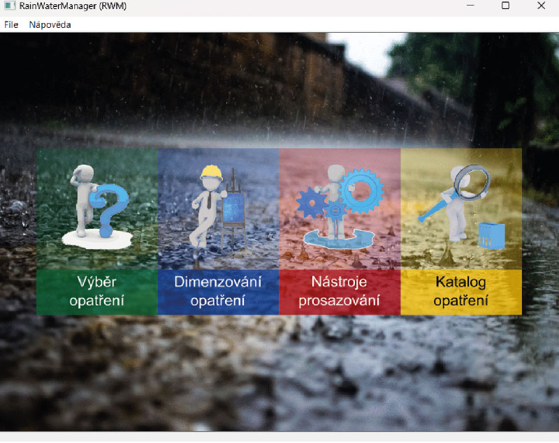
Fig. 1. RWM software splash window
„Measure selection“
This module helps the user to choose the appropriate RWM measure. The user chooses preset answers to 11 questions. The questions cover a wide range of areas including thematic focus, use of space, natural conditions, local restrictions, and costs of implementation and maintenance. There are a total of 38 possible answers. The answers are used as input criteria for evaluating the appropriateness of measures. Multi-criteria analysis (MCA) is used for this evaluation [11, 12]. In the MCA process, all RWM measures available in the RWM software are evaluated. Based on the choice of a specific criterion, all RWM measures are scored. The degree of scoring depends on the degree of appropriateness of the given measure for the chosen criterion. If the chosen criterion fully corresponds to the needs of the given measure, it is evaluated with a full number of points. In other cases, the measure is evaluated with fewer points depending on the degree of correspondence. A point scale of 1–5 is used for the assessment (1 – the least, 5 – the most). With each addition of another criterion, each measure is assigned a relevant number of points. The measure that thus receives the highest point evaluation is selected as the most appropriate. The point values of the relationships between criteria and measures are defined in a preference matrix. This matrix has been preset to achieve maximum objectivity. However, the user can modify the preference matrix and thereby inject their own preferences into the MCA process.
MCA results are shown both graphically and numerically. Each measure is assigned a pictogram within the RWM. Pictograms are sorted in descending order based on the achieved point score from the MCA. The relative value of the score (max. 100 %) is shown under the relevant pictogram. The presentation of MCA results in the „Measure selection“ window is shown in Fig. 2. After clicking on the pictogram, the user is shown a detailed description of a specific RWM measure and its application in practice.
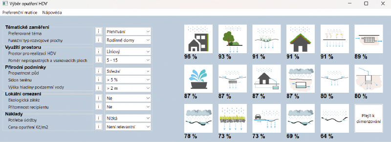
Fig. 2. Presentation of MCA results in the „Measure selection“ module
„Measure dimensioning“
In this module, the user can simply calculate the values of selected hydrological characteristics in the area and the effect of the selected RWM measure on these values. The user can thus evaluate the necessary scope of the planned measure, its effectiveness, or price. The graphic form of the „Measure dimensioning“ panel is shown in Fig. 3.
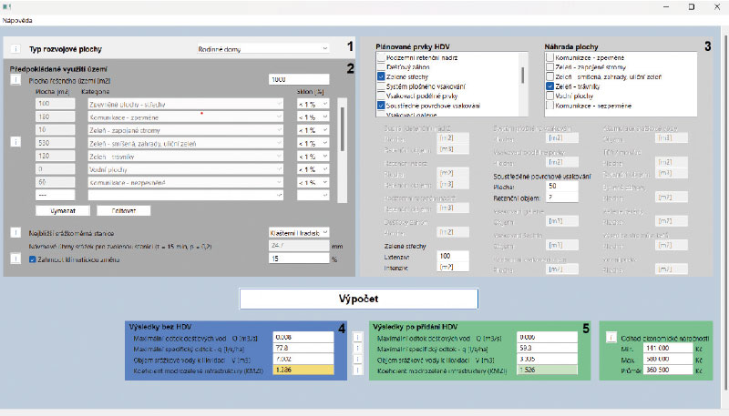
Fig. 3. Graphic form of the „Measure dimensioning“ module
For the primary estimation of hydrological characteristics, it is necessary to enter a simplified description of the expected use of the site. The user enters the sizes of the individual areas that together form the area of interest, selects their type from the menu, and assigns them an inclination value. It is also necessary to indicate the amount of design rainfall. It is possible to enter the amount of rainfall manually (knowledge of the amount of precipitation for rain with a duration of t = 15 min and a repetition time of p = 0.2 for the given site is required), or use data from the nearest rain gauge station offered by the program. The calculation can also consider the expected influence of future climate change on the value of precipitation intensity [4, 13, 14]. The calculation itself is implemented based on the rational method [15]. The selected hydrological characteristics are the values of maximum stormwater runoff, maximum specific runoff, and volume of rainwater to be loaded. Furthermore, the blue-green infrastructure coefficient (BGIC) is calculated.
The type and extent of RWM measures that the user intends to implement can then be added to the primary estimate. It is also necessary to enter what type of area will be replaced by the measure. Subsequently, there is a new calculation, which takes into account the effect of RWM measures on selected hydrological characteristics. When selecting a RWM measure, the estimated cost of its implementation is also calculated.
„Enforcement tools“
The „Enforcement tools“ module is primarily intended for the public administration representatives. It is an overview of tools that can be used to support and promote effective stormwater management in urban and municipal development sites. The individual tools are based on published general lists of tools and their specifications. They are categorized according to the hierarchical level of public administration, the subject concerned, and the phase of the process (planning, implementation, operation). The goal is to find the most suitable tool for the given situation. In total, 18 types of instruments are processed, divided into 5 categories (normative; conceptual; coordination and organizational; economic; voluntary and ethical) [16]. The MCA method [11, 12] is again used for tool selection. MCA criteria are determined based on the choice of answers (17 possible answers in total) to four initial questions. The presentation of the results is similar to the „Measure selection“ module; it is also possible to go to the detail of the given tool by clicking on the pictogram. The graphic form of the „Enforcement tools“ module is shown in Fig. 4.
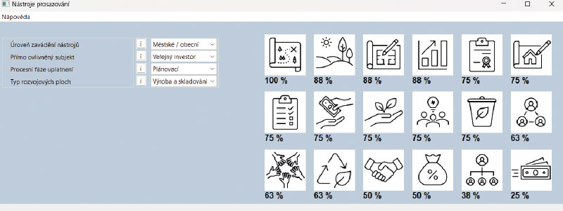
Fig. 4. Graphic form of the „Enforcement tools“ module
„Catalogue of measures“
The software also includes a full-fledged digital version of the Catalogue of Measures for Effective Rainwater Management on Development Areas of Urbanized Areas [10]. The catalogue contains information about the project framework and its connection to the TA CR project „SS03010080 – Interdisciplinary approaches to efficient rainwater management on development sites of urban areas in the economic, social and environmental context“, the methodology of creating the catalogue, the catalogue of effective rainwater management elements, the catalogue of functional types of development sites, and the catalogue of tools for the promotion of effective rainwater management.
The RWM software is designed as a standalone application (*.exe) developed in the C++ programming language. It does not require an installation. The software is available in the form of a distribution package, which contains the RWM program and the attached documents to which reference is made (catalogue of RWM measures). The use of the software is not charged or otherwise restricted. The software can be found at: https://www.fzp.czu.cz/rwm
RESULTS
The RWM program serves to support decision-making in the area of stormwater management. The results it provides to the user also correspond to this. The „Measure selection“ and „Enforcement tools“ modules help the user in the decision-making process regarding the choice of the RWM measure itself, or finding a way for its enforcement in practice. These decisions are supported by detailed descriptions of individual measures (tools) supplemented by examples of their use in practice. Another type of results is offered by the „Measure dimensioning“ module. Here, selected hydrological characteristics are estimated in a simplified manner without RWM measures and subsequently with their consideration. The user thus gets an idea of the effectiveness of the selected RWM measure. A price estimate for implementation is also calculated. Thanks to this, the user has the opportunity to compare the economic and functional efficiency between individual types of measures.
Other results are:
- Maximum rainwater runoff – indicates the maximum runoff (flow) of water (Q [m3/s]) that flows out of the area after/during a precipitation event. The calculation is carried out using the rational method according to the SN 75 6101 standard.
- Specific runoff – q [l/s/ha] expresses how much water flows per unit of time from a unit area of the basin (sub-basin).
- Unprocessed volume of precipitation water – indicates the volume of water (V [m3]) that will flow from the area after/during a precipitation event with a duration of 15 min. The calculation of this volume is based on the rational method (SN 75 6101).
- Blue-green infrastructure coefficient (BGIC) – evaluates the statistics of areas in terms of green ecosystem functions (e.g. microclimate, biodiversity, residential function) and natural water circulation functions (retention, infiltration, evaporation, and water purification).
- Estimate of economic demand – this is an indicative price for the implementation of the given RWM measures. The price is calculated as the unit price (CZK) for 1 m2 (or 1 m3) of the implementation of the given RWM measure, multiplied by the given number of units. In the case of selecting several measures, it is the sum of the prices for the implementation of individual measures.
DISCUSSION
The purpose of RWM software is not in any way to replace the design work associated with the proposals for rainwater management measures. It is primarily oriented towards raising awareness of the issue for small investors and public administration representatives. This is also reflected in the very concept of the software, which tries to simplify the given issue as much as possible, supplemented by a lot of explanatory information. RWM is intended to help these user groups raise awareness of the possibilities of using individual RWM measures and their influence on the hydrological situation in the area they manage. Users can thus obtain, for example, information about the extent of RWM measures that must be implemented so that there is no runoff from their property, or get an overview of the prices for the implementation of these measures. For public administration representatives, the „Enforcement tools“ module further shows the ways in which the construction of these measures can be enforced within their municipality. However, this does not mean that RWM cannot be used, for example, by users from the ranks of civil engineers or designers. It offers these groups the possibility of a quick orientation assessment of individual RWM measures, or help with estimating the spatial and economic requirements for the implementation of the measures planned. The program can also be used by students of economic or technical fields who encounter the issue during their studies.
The „Measure selection“ and „Enforcement tools“ modules use the MCA method in their decision-making mechanisms [11, 12]. It allows comparison of evaluation criteria from different areas of interest (with different units, binary, etc.). In the case of the „Measures selection“ module, criteria are chosen for selection that consider natural, technical, and legislative restrictions for construction, which result mainly from the requirements of the relevant technical standards [17, 18]. The functional type of the development area considers the appropriateness of the application of individual measures for different types of urban development [10]. It also includes criteria of social need (e.g. the need to deals with drought, floods) or criteria that resulted from communication with representatives of local governments (cost of implementation, need for maintenance). The MCA process can also work with the individual preferences of the evaluator. In the case of RWM, this means that the user can enter this process and modify the set values of the preference matrix. The default setting was made after extensive discussion by the research team of the SS03010080 project. The evaluation criteria in the „Enforcement tools“ module were selected and evaluated mainly on the basis of a professional literature search (both Czech and foreign) and on the basis of experience from pilot sites and consultations with state administration representatives [19].
The hydrological characteristics produced by the „Measure dimensioning“ module are calculated on the basis of the rational method, the modification of which for these purposes is specified in the SN 75 6101 standard. During the calculation, the RWM program considers constant-intensity rain with periodicity p = 0.2 and duration t = 15 min. The values for these rains are taken from the TNV 75 9010 standard. However, the question is whether the data on these rains are up-to-date. The list of stations, for example, also includes stations that no longer exist (e.g., Plze – Doudlevce). However, RWM offers the possibility to enter current, locally valid data.
The selection of hydrological characteristics considers general requirements for rainwater management. The value of maximum runoff is important for the user, especially in connection with drainage of water that has not been infiltrated or retained on the property. This runoff is drained in the direction of the hydraulic gradient into the recipient (rain sewer, watercourse). In their regulations, the recipient administrator can require compliance with the maximum value of the inflow into the recipient. The specific runoff follows the requirements of the TNV 75 9011 standard, which recommends that the rainwater runoff does not exceed the value of 3 l/s/ha of the specific runoff. The unprocessed volume of stormwater indicates the value of the precipitation volume that has not been processed (retained, infiltrated) and will flow from the area. If the user wants to retain all the stormwater, they will know how much water still needs to be retained or infiltrated.
RWM also works with the predicted influence of climate change on rainfall intensity values. In this regard, some studies focus on seasonal forecasts [4, 13] while others on specific rainfall duration [14]. Studies agree that there will be an increase in precipitation intensity. The question remains how big this increase will be. RWM uses a relative increase in precipitation intensity for these facts (and also due to their uncertainty). By default, the value is set to 15 %, while the allowed intensity increase range is 10–20 %.
The results also include the blue-green infrastructure coefficient (BGIC). This index evaluates RWM measures in terms of green ecosystem functions and natural water cycle functions. The index was introduced within the SS03010080 project. The reason for its introduction was the absence of a similar index in the Czech Republic. The most similar indices in this respect were the HGF (Helsinki Green Factor) [20] and BAF [21] indices. However, none of these factors is adapted to the Czech environment – it does not provide values for all intended RWM measures and categories of areas set for runoff coefficients, on the basis of which the calculation is carried out using the rational method. For this reason, the missing values were expertly estimated based on the analysis of foreign literature [20–23].
CONCLUSIONS
The aim of this paper is to present RainWaterManager (RWM) software, to describe its basic functions, and the possibilities of its use. RWM software is designed as a supporting element in deciding on the choice of a suitable measure for rainwater management (RWM). It helps users with the choice of a suitable RWM measure by determining its indicative scope, effectiveness, cost-effectiveness, and by finding mechanisms to enforce the implementation of these measures in practice. RWM also includes a catalogue of RWM measures. In the catalogue, individual measures are described in detail and examples of their application in practice are given. RWM is primarily intended for users from public administration and the general public. However, its results can be used by civil engineers, planners, and university students who encounter the planning of RWM measures or the evaluation of their socio-economic functions during their studies.
Acknowledgements
The paper was created with the support of the Environment for Life programme of the Technology Agency of the Czech Republic and the project „SS03010080 – Interdisciplinary approaches to efficient rainwater management on development sites of urban areas in the economic, social and environmental context“.
The Czech version of this article was peer-reviewed, the English version was translated from the Czech original by Environmental Translation Ltd.
