ABSTRACT
Suitable areas for the accumulation of surface water have been defined in the Czech Republic, potentially serving mainly for the supply of potable water and for mitigating the adverse effects of floods and drought. The sites are listed in the General Scheme on the Accumulation of Surface Water, which was obtained by the Ministries of Agriculture and the Environment following the previous long-term territorial protection of prospective water reservoirs. Before any decision to build these reservoirs, it is necessary to assess the project from various points of view. This article presents an evaluation of selected sites from a hydrogeological point of view. Among other things, it deals with the analysis of the location of potential reservoirs in the hydrogeological environment, the effect on the quantity and quality of groundwater, and the potential impact on the used groundwater resources. After the construction of the reservoirs, the groundwater level of the shallow aquifer will rise, and consequently, groundwater storage will also increase. However, it is necessary to assess the sites individually; there are often potentially negative effects of future reservoirs on groundwater.
INTRODUCTION
Surface water accumulation, whether natural or artificially constructed, have a significant effect on the circulation of groundwater in their vicinity. An increase in the level of the erosion base leads to a rise in the groundwater level in the vicinity of a reservoir – at a greater extent above the reservoir dam. The presented article deals with the potential influence of the areas defined in the General Scheme on the Accumulation of Surface Water [1] (hereinafter referred to as General LAPV) on hydrogeological conditions and groundwater resources. Currently, 96 sites are protected by the General LAPV. The development of the number of protected areas for surface water accumulation (LAPV) and their potential for mitigating the effects of climate change is summarized, for example, by [2, 3]. General LAPV is the basis for the proposal of the territorial development policy and spatial planning documentation. It is not a plan for the construction of water reservoirs, but a basis for spatial planning, so as not to prevent or substantially complicate any implementation in the future [1].
The aim of the article is to inform about the treatment of LAPV hydrogeological issues within the Research Project SS02030027 – „Water systems and water management in the Czech Republic in conditions of climate change (Water Centre)“. In this phase, basic hydrogeological data (‚passports‘) on individual sites are being processed. This paper presents three examples of sites for different hydrogeological environments. Due to the difficulty in preparing any future reservoirs, a more detailed survey will only be undertaken in the event of a decision on their actual construction. Mathematical modelling, regime measurement, and geophysical survey can be used as appropriate tools for assessing the influence of valley reservoirs. A detailed geological survey would then take place before construction itself.
GIS tools [6] with available basic data on the location of these areas are a suitable tool for the preliminary assessment of selected sites and the acquisition of data for deciding on the possible implementation of a hydraulic structure. As part of the „Water Centre“ project, spatial data and basic data are obtained for each site; at some of the sites, flow and other parameters are monitored.
Location of LAPV from a hydrogeological point of view
Protected areas for surface water accumulation (LAPV) were initially selected mostly on the basis of criteria other than the hydrogeological ones. For example, the morphological point of view (possibility of an effective construction of a dam) was important, which is, however, closely related to geological conditions. An overview of the hydrogeological situation of the LAPV location in the Czech Republic is shown in Fig. 1.
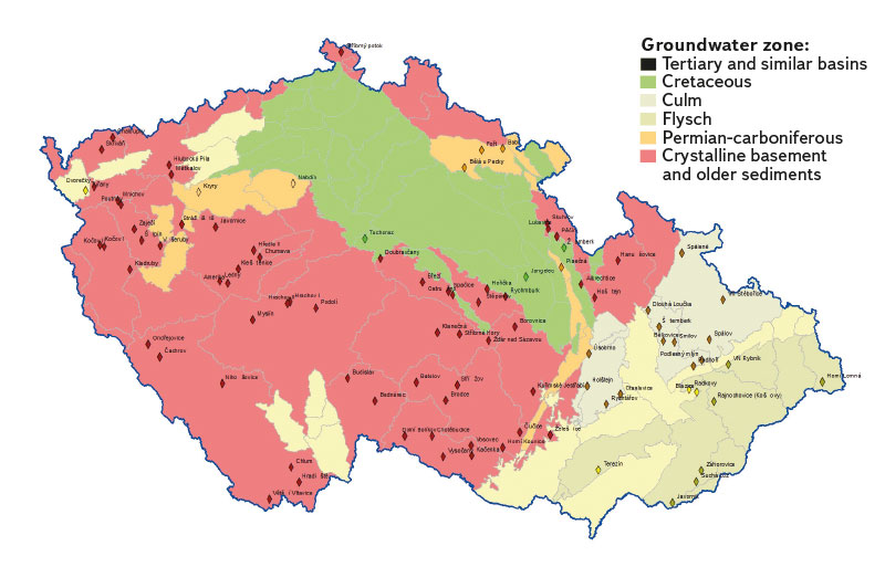
Fig. 1. Groups of hydrogeological regions of the base layer of the Czech Republic with the location of protected areas for surface water accumulation (according to Decree No. 5/2011 Coll.)
More than half of the Czech Republic (about 57 %) is made by hydrogeological massif [4]. It includes crystalline rocks, as well as sediments of the Proterozoic and older Palaeozoic, and Culm rocks. They usually only have a limited circulation of groundwater, mainly tied to the sub-surface layer of the Quaternary cover and semi-open bedrock. The vast majority of LAPV (80 %) is located within the hydrogeological massif. Therefore, the percentage representation of LAPV in the massif significantly exceeds its areal extent. LAPVs have been delineated in both crystalline and older Palaeozoic or Culm rocks. For example, over 14 % of all sites are found in Culm rocks. A total of 76 sites for reservoirs with an average volume of 21.2 million m3 (with an average dam height of 38 m) and a total catchment area of 8,715 km2 have been selected in the hydrogeological massif.
In the Bohemian Massif, solid carbonate rocks also occur, especially limestone and crystalline limestone, which, in addition to fissure permeability, often have karst permeability. These tend not to be suitable for reservoir locations due to the possible leakage of water through karst systems. Thus, there are no LAPVs in these rocks.
The rocks of the flysch zone of the Western Carpathians also have the character of a hydrogeological massif; they form a strip of land along the eastern border of the Czech Republic and cover over 8 % of the country. 8 % of LAPV sites were proposed here, which corresponds to the spread of these rocks in the Czech Republic. In total, eight reservoir sites have been selected here, with an average volume of 8.7 million m3 (with an average dam height of 31 m) and a total catchment area of 251 km2.
In a smaller number of the sites, the subsoil is made up of sedimentary rocks, which, in addition to the majority of fissure permeability, also have pore permeability. In the case of the reservoir construction and in the longer term, there will be an increase in static groundwater supply in the vicinity of these sites. The impact of valley reservoirs will be mostly local, caused by an increase in the erosion base above the dam.
Permian-carboniferous basins and occurrences occupy an area of about 5.8 % of the Czech Republic. In addition to fissure permeability, Permian-carboniferous rocks also have pore permeability. 6 % of LAPV sites are located on these rocks, which corresponds to the widespread distribution of this hydrogeological environment. In total, six sites for reservoirs have been selected in the Permian-carboniferous rocks, with an average volume of 6.8 million m3 (with an average dam height of 26 m) and a total catchment area of 251 km2.
In terms of water management, the Czech Cretaceous Basin is the most important hydrogeological structure in the Czech Republic. Although it covers over 15 % of the country, only 3 % of LAPV was located in the groundwater zones of the Czech Cretaceous Basin. At the other five sites, the Cretaceous groundwater zones are affected by the protected area marginally (LAPV Doubravčany, Hořička, Ostružno, Rychmburk, and Albrechtice). The significantly lower suitability of this structure for LAPV is caused, among other things, by morphological conditions, the high permeability of the rocks, and the existence of important sources of (ground)water. The construction of reservoirs could therefore be aimed at the artificial infiltration of surface water into the rock environment instead of creating surface water accumulation (e.g. [7]). In total, three sites for reservoirs have been selected in the Czech Cretaceous Basin, with an average volume of 13.6 million m3 (with an average dam height of 27 m) and a total catchment area of 458 km2.
In the rocks of the Cenozoic basins (with Tertiary and Upper Cretaceous filling), LAPVs are very sporadic, partly for similar reasons as in the Czech Cretaceous Basin. Neither the South Bohemian basins nor the Mostecká (North Bohemian) and Sokolovská basins have any defined LAPV. It should be noted that the large water bodies created in recent decades in the Mostecká and Sokolovská basins are not LAPV, but are formed by flooding of surface mines. One LAPV site is linked to the Tertiary Cheb basin (more detail in Fig. 4); the same applies for the Vídeňská basin. Only two LAPV sites are linked to Tertiary filling regions of the Carpathian depression (Blazice and Radkovy). In total, three sites for reservoirs have been selected here, with an average volume of 11.8 million m3 (with an average dam height of 23 m) and a total catchment area of 79 km2.
Quaternary sediments on the surface represent the most widespread geological unit in the Czech Republic. Particularly in the case of hydrogeologically important accumulations of highly permeable Quaternary sediments, these areas were separated into groundwater zones of the upper layer. Only at two LAPV sites do the floodplains of the reservoirs extend into the upper groundwater zone of the Quaternary sediments (Tuřany in the Ohře basin and Rybník water reservoir in the Odra basin). The influence of these valley reservoirs on groundwater circulation will be positive. Due to the higher permeability of the rock environment, there can be a relatively intensive spontaneous infiltration of surface water into groundwater and an increase in the groundwater level in the vicinity. However, an increase in the groundwater level can also have negative effects, such as the emergence or increase of the risk of slope instability and waterlogging of agricultural land.
Municipalities affected by drought and LAPV
Approximately one third of the LAPV was defined in the cadastral area of municipalities affected by drought, where the possible construction of water reservoirs could contribute to improving the situation. Fig. 2 shows the map of LAPV and municipalities affected by drought..
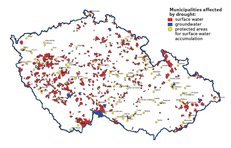
Fig. 2. Cadastral area of municipalities affected by drought from the point of view of potable water supply (issue in the entire municipality) in the Czech Republic with LAPV sites (HEIS, 2020)
The map in Fig. 2 clearly shows that issues occur mainly in connection with groundwater. Therefore, it is also necessary to address the question of whether and to what extent the implementation of LAPV reservoirs could contribute to improving the quantitative state of groundwater in times of drought, as well as its possible use by municipalities.
In sites of hydrogeological massif, where a substantial part of the LAPV is located, usually only the shallow groundwater cycle of groundwater from the collection facilities is used. The most abundant ones are often located near watercourses. In recent years, as the demand for local resources for municipalities and individual houses has increased, the number of deeper hydrogeological wells that use groundwater from the fissure system has also increased. The influence of valley reservoirs on groundwater circulation will mostly be significant only within the framework of shallow groundwater cycle.
General hydrogeological changes caused by construction of water reservoirs
From a general point of view, when a surface water reservoir is built and filled, the groundwater level of a shallow aquifer in a given area increases.
Groundwater storage is created by the infiltration of rainwater and its accumulation in the rock environment. In places of erosion base, the rock environment is naturally drained into surface streams. By changing the height level of the erosion base, e.g. by building a hydraulic structure, the runoff conditions will change. In the case of suitable conditions, partial infiltration of surface water into groundwater can occur.
By building dams and flooding the floodplain of watercourses, the level of groundwater and surface water will be connected, however, with a certain delay depending on the distance from a water reservoir.
In general, we can say that the construction of a hydraulic structure and its flooding will have a positive effect on the groundwater status both above the dam (by raising the level of the shallow groundwater cycle) and below the dam (by stabilizing surface runoff). Previous experience shows that even a small increase in the surface water level (e.g. by building a weir [5]), has a positive effect on the increase in the groundwater level in the watercourse vicinity.
The yield of natural groundwater resources will remain similar because permeability is determined by the nature of the rock environment. However, the possible accumulation of surface water will – under suitable conditions – fulfil the function of an additional water source (for infiltration of precipitation) by surface water overflowing into groundwater.
Mathematical modelling can also be used for a comprehensive evaluation of changes in the groundwater flow regime after the hydraulic structure construction. It is also possible to simulate different modes of future use with a mathematical model. The groundwater flow model, together with the rainfall-runoff model, will create a comprehensive picture of the effect of a hydraulic structure on water cycle in the given site. However, the processing of mathematical models is time- and financially demanding, and together with the necessity of updating for changing climatic conditions, it is advisable to proceed to this step only after the decision on implementation of the hydraulic structure has been made.
Examples of individual LAPVs and their specific hydrogeological issues
LAPVs were spatially defined and given basic characterization. As part of basic data collection of individual sites, in addition to the basic geological and hydrogeological conditions, the area protection, groundwater resources, and possible risks were identified and briefly described. Some of them are subject to hydrological monitoring – measurement of flows and conditions on watercourses. In order to capture the specific hydrogeological issues of individual LAPVs, steps were taken to compile hydrogeological passports. An example of such a passport is shown in Fig. 4. In the following text, we present three examples of LAPV in different hydrogeological environments and their selected specific hydrogeological issues.
Example of LAPV in hydrogeological massif – Pěčín on the river Zdobnice
The most common hydrogeological environment where LAPVs are located is hydrogeological massif. The groundwater cycle here is mainly tied to the zone of sub-surface semi-opening of bedrock and Quaternary sediments. An example of LAPV in a hydrogeological massif is Pěčín on the river Zdobnice, in Orlické mountains. Pěčín reservoir is designed, among other things, to supply the inhabitants of the Hradec Králové region with potable water. In the case of Pěčín, a more detailed geological survey focused on the construction of a water reservoir had already been carried out in the 1980. As part of the filling of the reservoir, groundwater level of the shallow aquifer will rise in the now unsaturated backwater area and in its surroundings, and thus groundwater storage will also increase [8].
One of the attractions of LAPV Pěčín is the old mine works (Fig. 3) and the planned tailings heaps at the bottom of the future reservoir. Despite documented (sporadic) occurrence of sulphide ore minerals on these heaps, these old environmental loads should not threaten surface water quality of the planned reservoir.
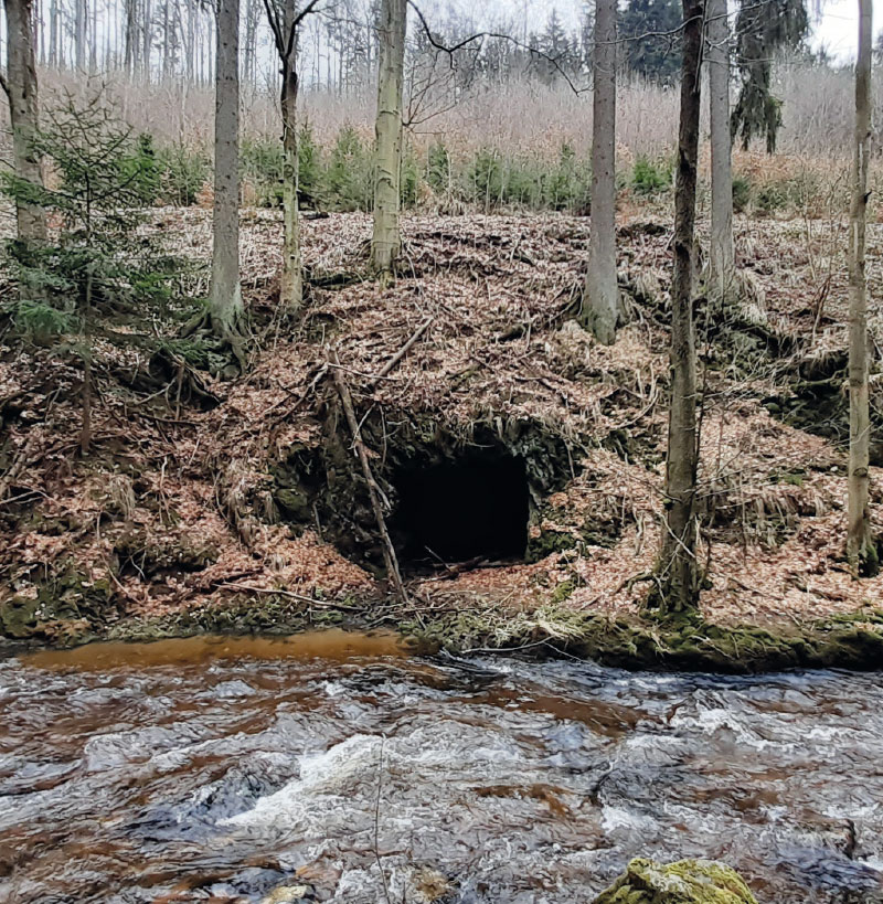
Fig. 3. Adit (exploration gallery) in Zdobnice valley (LAPV Pěčín)
Example of LAPV basic data on Tertiary and Quaternary sediments – Tuřany in the Cheb basin
LAPVs are located only very rarely in Tertiary sediments and Quaternary zones of the upper layer. An example of such a site is Tuřany on the Šitbořský stream in the Tertiary Cheb basin.
The high permeability of Quaternary sediments in particular when the area is flooded after the construction of the planned reservoir can cause intensive infiltration of surface water into groundwater and their outflow outside the site of interest. Hydrogeological details of the site are given in the hydrogeological passport in Fig. 4.
Site name: Tuřany
Watercourse: Šitbořský potok
Groundwater zone – number: 2110
Groundwater zone – name: Cheb basin
Morphology, width of the valley floodplain: Shallow valley – the dam will completely flood the floodplain sediments
Geological and lithological characteristics
The predominant rock type in the site is the sedimentary rocks of the Cheb basin. There are lacustrine sediments of the cypress formation: claystones, clays and pelagic carbonates, sands in the coastal zone. They are followed by sedimentary sequence of the Wildstein Formation, from clays to sands and gravel-sands at the end of the youngest stage. Relics of river terraces (Mindel-Riss age) are preserved here. The Quaternary cover consists of a layer of fluvial and deluvio-fluvial sediments, with a thickness of up to 6 m in the vicinity of a watercourse. East of the Šitbořský stream, there are loess and loess loam in the overlying rock of Neogene sediments.
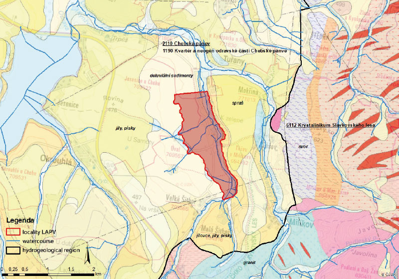
Fig. 4. An example of a hydrogeological passport of a locality LAPV (Tuřany in Cheb basin)
The site on a geological map (Source: mapy.geology.cz), including groundwater zones:
Tectonics
The most significant tectonic fault in the vicinity is the Mariánské Lázně complex, running about 1,500 m east of the Šitbořský stream in a north-south direction. At the southern end of the predicted floodplain, a fault runs in a SW-NE transverse direction.
Hydrogeological characteristics
The site is located in the groundwater zone of the base layer 2110 Cheb basin and the groundwater zone of the upper layer 1190 Quaternary and Neogene of the Odravian part of the Cheb basin. The sedimentary sequence of the Cheb basin creates conditions for the alternation of insulators and flow collectors, especially in the sediments of the Wildstein Formation, T = 2 × 10⁻⁴ to 1 × 10⁻³ m2/s.
The sediments of the cypress formation form a regional insulator, but in the Cheb basin, in contrast to the Sokolov basin, they are more permeable,
T = 5 × 10⁻⁵ to 3.5 × 10⁻³ m2/s. In the vicinity there are spatially limited, pore permeable collectors tied to river terraces, T = 1 × 10⁻⁴ to 1 × 10⁻³ m2/s. The direction of groundwater outflow is northwest to north – to the erosion base formed by the Ohře.
Groundwater collection
Groundwater resources in the immediate vicinity of the site are not registered. The site is located in the Nebanice 2nd degree protection zone for vulnerable water resource. Its collection facilities are located on the opposite bank of the Ohře, so their influence is improbable. Building a water reservoir will increase the groundwater level in the vicinity and infiltration into the permeable layers of the rock environment.
Verification of the presence of old environmental loads
In the Šitbořský stream basin and its tributaries, two sites are recorded that can negatively affect groundwater and surface water quality. The first is a former petrol station in the village of Malá Šitboř (risk of oil pollution) and the second is an agricultural facility south of the village of Tuřany (risk of oil pollution). Both sites are registered in the Contaminated Sites Registration System database (SEKM).
Verification of protective zones of water resources, protection areas, geohazards, undermining
The site is located in the protection zone of natural healing resources: IIb – Františkovy Lázně and Mariánské Lázně, and in the protection zone of groundwater resources of the 2nd degree – Nebanice underground resource. The site is a part of the Cheb basin and Slavkovský les protected area of natural water accumulation. Along the eastern edge of the site runs the boundary of the PLA Slavkovský les. The southern edge of the site adjoins an area with a high radon index, there are also old mines for the exploration of radioactive raw materials. In the vicinity of the site and also on the banks of the Jesenice water reservoir, slope instabilities appear, the area falls into the territory of the medium class of landslide susceptibility.
Summary
Šitbořský stream currently mainly has a discharge effect on shallow groundwater cycle. The dam will cause a local rise in the groundwater level below the reservoir and in the immediate vicinity. Consequently, in places where there is a collector with a free water level and an unsaturated zone above the groundwater level, the groundwater supply will increase locally. After the situation stabilizes, it can be assumed that surface water will infiltrate into the permeable layers of gravel-sand of the river terraces, or sand layers of Neogene sediments. In the vicinity of the dam, surface water infiltration and groundwater discharge will occur below the dam.
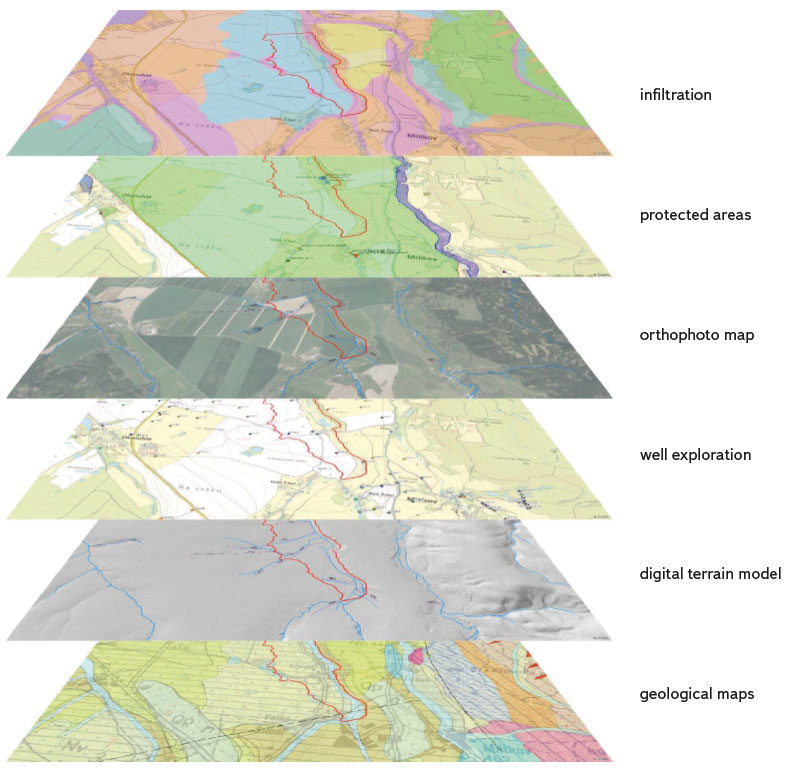
Fig. 5. An example of a possible summary of data on map for a location LAPV Tuřany (Data source: HEIS, Czech Geological Survey, The Ministry of the Environment and The Ministry of Agriculture of the Czech Republic, Cenia, etc.)
An example of LAPV on Permian-carboniferous and Cretaceous sediments – Tuchoraz on the Šembera stream
The classification of individual LAPVs into groundwater zones sometimes does not fully correspond to the real hydrogeological environment. An example can be LAPV Tuchoraz on the Šembera stream in the Central Bohemian region. The Tuchoraz site belongs to the Cretaceous region 4350. In reality, however, the subsoil of the reservoir bottom will consist mainly of Permian deposits, covered at the surface by Quaternary sediments. Only the marginal higher side parts of the bottom when the reservoir is fully filled will be formed by the sediments of the Czech Cretaceous Basin (Fig. 6).
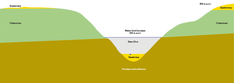
Fig. 6. Schematic geological exaggerated section of locality LAPV Tuchoraz, Šembera stream
In the Šembera valley, in the potential area of the LAPV backwater, there are three important collection areas for supplying municipalities with potable water, and this is a more general issue. More significant groundwater collections are usually located in the valleys of watercourses, as there are often significantly more favourable conditions for these collections. Usually, there is the highest thickness of highly permeable fluvial Quaternary sediments. The valleys of watercourses tend to be tectonically predisposed, and their bottoms therefore tend to have stronger permeability due to the tectonic disruption of bedrock. There is a more or less constant groundwater level shallow below the terrain. Last but not least, in this environment, there is the possibility of improving the collection of groundwater by bank infiltration from the watercourse.
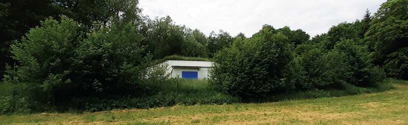
Fig. 7. Groundwater pumping facility in Šembera alluvial plain (LAPV Tuchoraz)
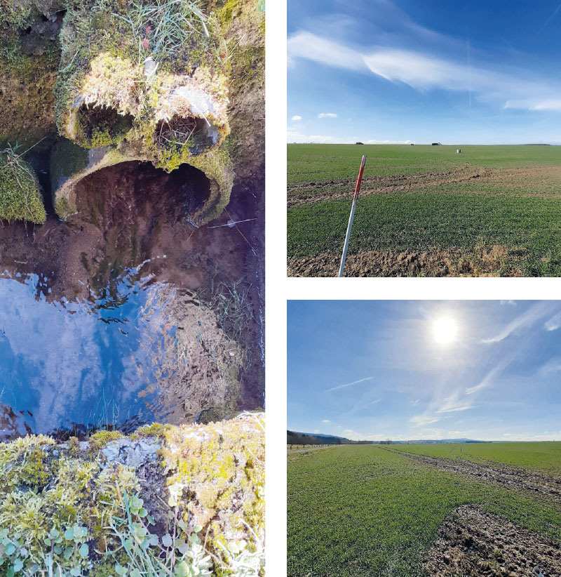
Fig. 8. Piped water flow/melioration in Šitbořský stream valley and the bottom of the future reservoir (LAPV Tuřany)
Groundwater collection facilities at the reservoir site will disappear. Due to the fact that the filling of the hydraulic structure with water will mostly flood the entire valley floodplain and the area where fluvial sediments occur, it will be possible to build potential collection facilities outside the zone of surface water spillage; i.e., either below the hydraulic structure dam or higher up along the watercourse. Building the reservoir close to municipalities dependent on groundwater resources from a shallow aquifer in backwater area may cause the need for accompanying investments in water management infrastructure, or even a total reconstruction of the supply network.
DISCUSSION
The construction of water reservoirs will lead to local changes in the regime of both surface water and groundwater. Groundwater circulation will be affected especially in the shallow horizon, which mainly includes Quaternary sediments deposited along watercourses. The spatial limitation of the influence of surface water accumulation on groundwater will depend on the character of the rock environment, especially on its permeability.
A significant part of the LAPV is located in an environment where the most suitable site for the location of a used groundwater source is the environment of fluvial sediments along watercourses. Building a dam and filling the reservoir will lead to the disappearance of any used groundwater resources (wells, etc.) in the extent of the flooded area; on the other hand, the conditions for the use of groundwater resources will improve in the vicinity of the reservoir.
By increasing the level of the erosion base, a more extensive fissure system can be connected in the hydrogeological massif, thereby improving the conditions for the use of individual groundwater resources in these areas.
The direct effect of surface water accumulation on groundwater quality will not be significant. The risk of groundwater contamination will remain essentially the same; however, a thorough survey of flooded areas must be carried out to prevent flushing out old landfills, mine waste dumps, etc.
We assume that if the surface water accumulation is implemented, the positive effect on the water management use of groundwater resources will prevail due to the onset of the water level and the increase in groundwater storage.
The discharge of municipal wastewater in particular has a significant effect on the quality of surface water and, subsequently, on the quality of groundwater. The effect of wastewater discharge on groundwater in individual cases will decrease, for example, due to the retention of surface water and other self-cleaning processes in the reservoir (e.g., reduction of faecal bacteria), as well as due to the stabilization of the outflow and the maintenance of a minimum flow below the reservoir during the year, and thus maintaining the dilution ratio.
CONCLUSION
Reservoirs constructed in LAPV areas will stabilize and equalize runoff and create groundwater storage. Their importance will grow with the predicted manifestations of climate change in the future.
However, it is necessary to assess the expected positive effect of LAPV reservoirs in detail for each site. On some LAPVs, the negative effects may prevail – for example, in places where groundwater resources for supplying municipalities are located in the valley floodplains of watercourses, and the accumulation of surface water could lead to the disappearance of these resources.
Acknowledgements
The article was created on the basis of research carried out as part of the project “Water systems and water management in the Czech Republic in conditions of climate change (Water Centre)” – SS02030027).
This article was translated on basis of Czech peer-reviewed original by Environmental Translation Ltd.
