ABSTRACT
This article presents the results of research on landscape changes in the Poděbrady region as part of the Polabí lowland, where there have been significant changes in the location of ponds. The area of all types of ponds (according to stability) makes up 3.17 % of the Poděbrady region. According to their occurrence in the area in 1836/1852–2022, the ponds (or their parts) were divided into disappeared, continuous, and new. Disappeared ponds have the largest representation – about 60 % of the total pond area according to stability. They are followed by continuous ponds, with the minimum area represented by new ponds. The historical or (more precisely) disappeared ponds were more robust than the present ones, i.e., they had a larger average size. Analyses show that almost three-quarters of the disappeared ponds have been replaced by arable land.
INTRODUCTION
The results presented here are part of a wider research concerning the Polabí lowland, where areas were selected with the greatest changes in the occurrence of wetlands, ponds (as one of the wetland types), small-scale protected areas, and well-preserved sections of watercourses.
The Pardubice and Poděbrady regions are designated as sites with the largest representation of historical or current ponds within the Polabská lowland, based on the state of the landscape recorded on the maps of Second Military Mapping and on contemporary documents. In this article, the results for the Poděbrady region are presented, and follow on from the research in the Pardubice region, whose results were presented in an article published in the previous issue of the VTEI journal [1].
Study area
The study area, which is located in the Polabí lowland in the Poděbrady region, was defined by the boundaries of the fourth order hydrological basins [2] in combination with the typology of the current landscape of the Czech Republic [3]. However, only those fourth order hydrological basins belonging to the warm landscape of the lowlands according to the mentioned typology were taken into account.
The study area of Poděbrady region is located on the edge of Poděbrady and includes the surroundings of Městec Králové and Rožďalovice. The defined area of Poděbrady region (Fig. 1) consists of 46 fourth order hydrological basins with a total area of 48,969.6 ha and covers almost the same area as the Pardubice region (50,104.5 ha). The following fourth order basins are part of the following third order basins: 1-04-04 Cidlina from Bystřice to the mouth and Elbe from Cidlina to Mrlina, 1-04-05 Mrlina and Elbe from Mrlina to Výrovka, and
1-04-07 Elbe from Výrovka up to Jizera [2].
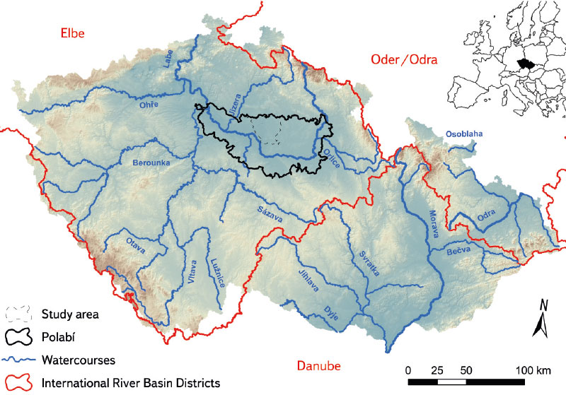
Fig. 1. Location of Poděbrady region within Polabí lowland
METHODOLOGY AND MAPS USED
The Poděbrady region is adjacent to Pardubice; both are part of the Polabí lowland. The same methodology was used in both study areas. The first step was the selection and subsequent comparison of the current and historical state of the sites of current and historical ponds based on map data interpretation. This was followed by a field survey of sites with the largest share of historical and current ponds to verify their current condition, or the state of the disappeared pond sites. The methodology for processing and interpreting map data was also identical. For the primary detection of the occurrence of ponds, the map of the Second Military Mapping was selected, available on the CENIA Geoportal as a WMS service [4]. To approximate the state of the landscape before Second Military Mapping, the map of the First Military Mapping was used, available in the map browser on the Arcanum Maps – The Historical Map Portal website [5], and Müller’s map of Bohemia from 1720, available in the map browser of the Land Surveying Office archive [6].
To display the current state of ponds and other water bodies, the current Basic Map of the Czech Republic 1 : 10,000 (BM 10) and the current orthophoto map of the Czech Republic available on the ČÚZK Geoportal [7] as a WMS service were primarily used. More detailed information about the methodology, the maps used, and the definition of the Polabí lowland area can be found in the previous article dealing with ponds in the Pardubice region [1].
RESULTS
During the initial visual detection and subsequent analysis of changes in pond location in the Polabí lowland based on the maps of the Second Military Mapping and current documents, two areas with the largest share of historical and current ponds were selected, namely in the Pardubice and Poděbrady regions.
In the following part of the article, the results for the Poděbrady region, presented in this article, are compared with the results from the Pardubice region. A cursory look at the study area of Poděbrady region on the map of the Second Military Mapping and the current BM 10 shows a clear decrease in pond area, and in particularly larger pond areas have disappeared or been reduced (Figs. 2 and 3). When looking at the documents of Müller’s mapping and the First Military Mapping, it is obvious that there was a greater representation of ponds in the course of the 18th century than in the middle of the 19th century in the Poděbrady region. The vast Blato pond near Poděbrady is worth mentioning, which is no longer found on the map of the Second Military Mapping (Figs. 4 and 5). Blato pond was one of the largest ponds in Bohemia, together with Čeperka pond in the Pardubice region and Rožmberk pond in the Třeboň region [4, 5, 8].
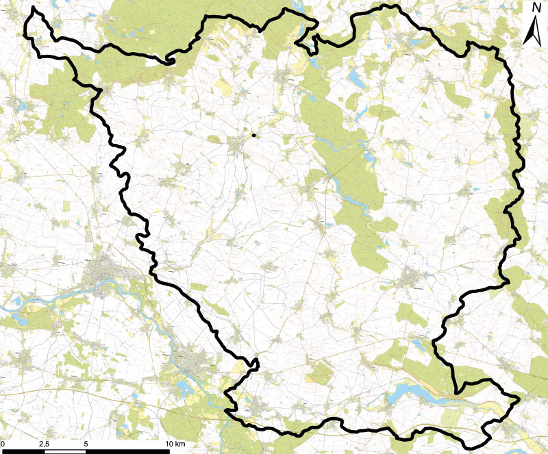
Fig. 2. The study area in the Poděbrady region on current BM 10
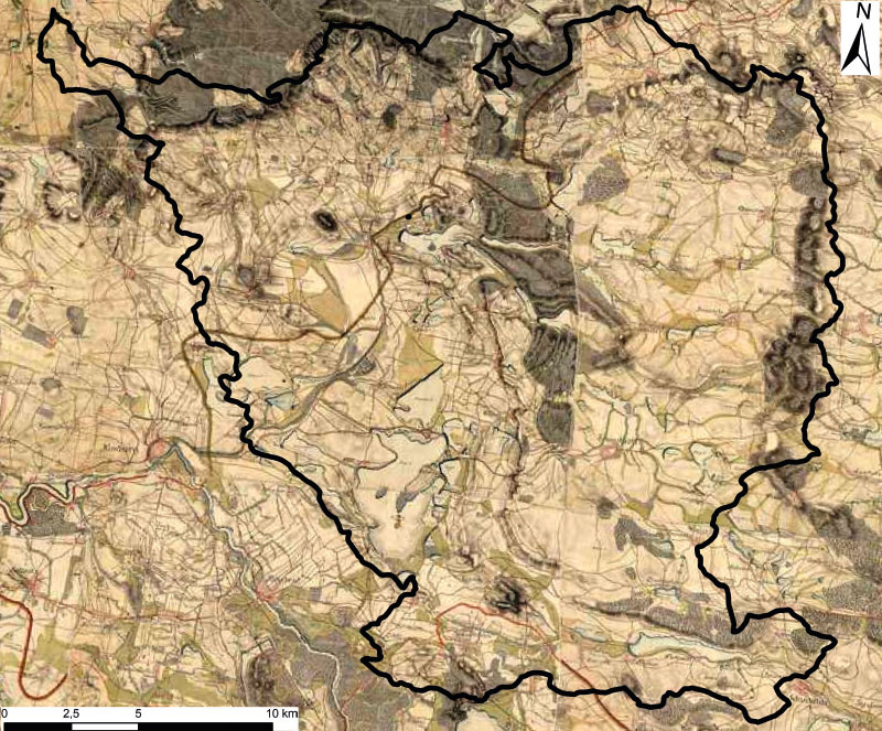
Fig. 3. The study area in the Poděbrady region on a map of the 2nd Military Mapping
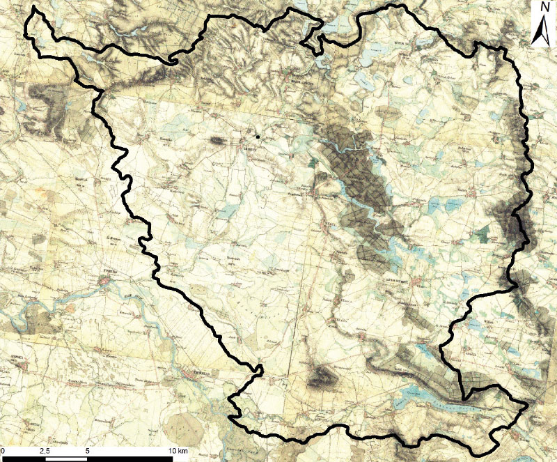
Fig. 4. The study area in the Poděbrady region on a map of the 1st Military Mapping
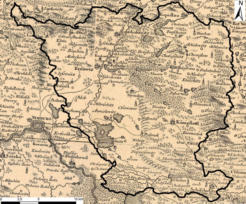
Fig. 5. The study area in the Poděbrady region based on Müller’s mapping
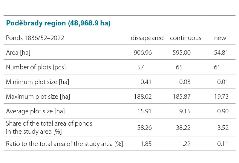
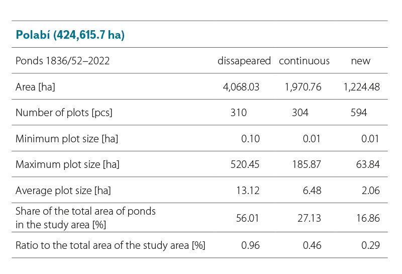
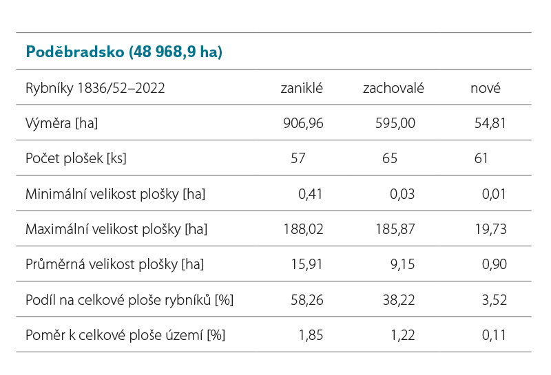
The area of all types of ponds according to stability makes up 3.17 % of the study area in the Poděbrady region. Disappeared ponds are the most represented – 58.26 % of the area of all ponds according to stability (906.96 ha). Continuous ponds follow with 38.22 % (595 ha), and new ponds occupy the smallest area with 3.52 % (54.81 ha) (Fig. 6, Tab. 1). The average area of disappeared ponds is 15.91 ha, continuous ponds 9.15 ha, and new ponds only 0.9 ha. The minimum size of the new ponds area is identical to the minimum size that was considered during the data analysis: 0.03 ha for continuous ponds and 0.41 ha for disappeared ponds. For the maximum size of the area, the largest were historical ponds (disappeared and continuous), while the new ponds are the smallest (Tab. 1).
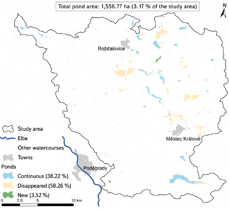
Fig. 6. Pond location development in the Poděbrady region
Tab. 1. Landscape-ecological characteristics of pond development according to stability in the Poděbrady region
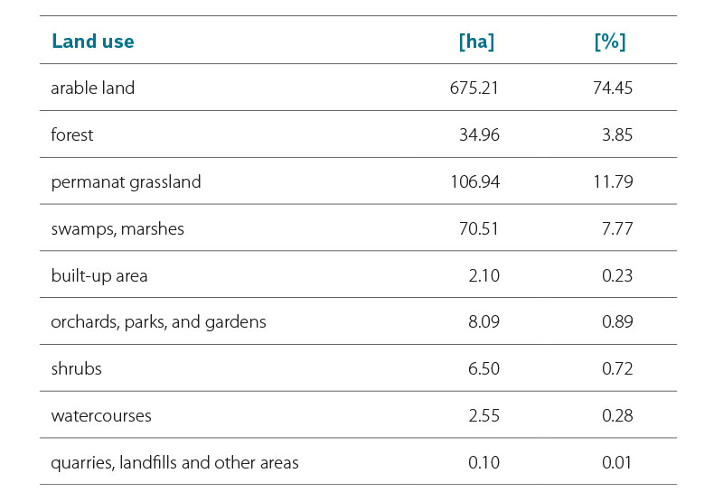
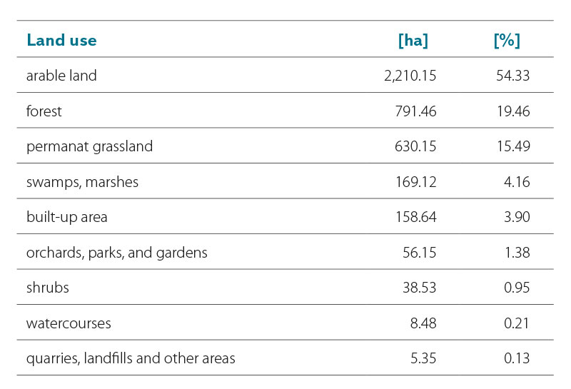
Arable land currently covers 74.45 % of the disappeared pond area; the share of permanent grassland (11.79 %) is also significant. Swamps and marshes replaced 7.77 % of the disappeared pond area, and forest 3.85 % of their area. Other land use types at the site of disappeared ponds do not exceed 1 % of their total area (Tab. 2).
Tab. 2. Current land use types in places of disappeared ponds in the Poděbrady region
When comparing the above results with data from the Pardubice region [1], it is clear that during the Second Military Mapping the total area of historical (i.e., disappeared and continuous) ponds in Pardubice was twice as large, and the total area of new ponds was six times larger; correspondingly, also a larger average size of their area. However, from the point of view of the maximum pond size, the larger ponds in the Pardubice region are disappeared and new, while the Poděbrady region these are continuous.
Pardubice and Poděbrady regions together occupy 99,073.4 ha, which is 23.33 % of the defined territory of Polabí. However, in both of these areas there are 77.91 % of the area of disappeared ponds, 72.84 % of continuous ponds, and 30.55 % of new ponds. In Polabí, there are historical and new ponds on 1.71 % of the area, in the Poděbrady region on 3.17 %, and in the Pardubice region on 6.83 % of the area. Pardubice and Poděbrady regions are also home to the largest areas of historical and new ponds.
Tab. 3. Landscape-ecological characteristics of pond development according to stability in the Polabí lowland
Tab. 4. Current land use types in places of disappeared ponds in the Polabí lowland
Based on a field survey in May 2023, the sites of the disappeared Nepokoj, Krčský, Štítarský, Záhorský, and Kněžický ponds are presented below.
The current state at the site of the disappeared Nepokoj pond near Svídnice is shown in Figs. 7–9. At this site, arable land shows signs of seasonal waterlogging at the site of the disappeared pond. There is also a straightened and deepened watercourse of the Štítarský stream.
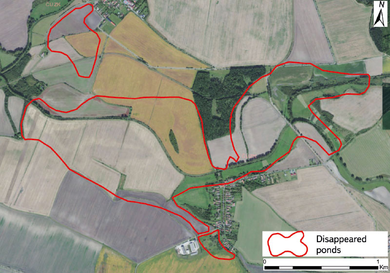
Fig. 7. Site of the disappeared Nepokoj pond based on the current orthophoto map of the Czech Republic
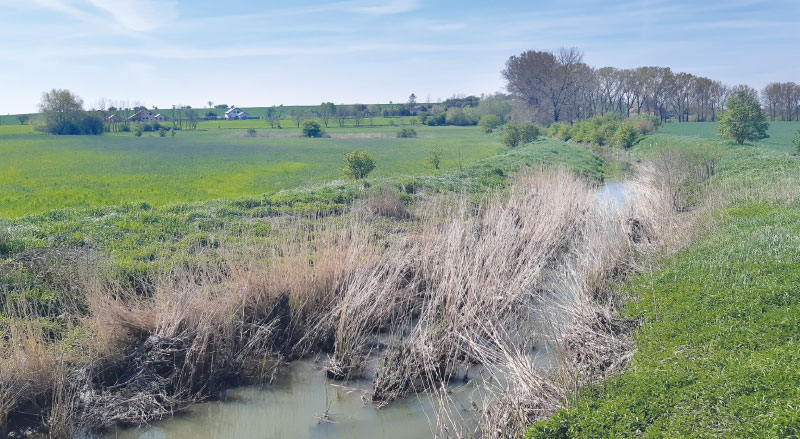
Fig. 8. Current state of the landscape at the site of the disappeared Nepokoj pond near Svídnice village (May 2023)
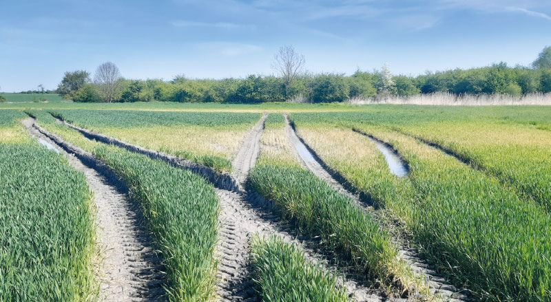
Fig. 9. Waterlogged arable land at the site of the disappeared Nepokoj pond near Svídnice village (May 2023)
The current state at the sites of disappeared or current Krčský and Štítarský ponds between Městec Králové and Vinice is shown in Figs. 10–14. At the site of both historical ponds there are currently much smaller bodies of water of the same name; this is especially true of Štítarský pond. Between the two current ponds lies Dymokursko natural monument (NM) [7]. There are reed beds at this site and the watercourse of Štítarský stream has been also straightened and deepened at the site of the disappeared pond. At Vinice, there is a grassy strip of several metres along the modified watercourse, and the area beyond it is used as arable land. On the left-bank tributary of the Štítarský stream, arable land extends to the watercourse, and signs of both seasonal waterlogging and flooding of arable land are visible.
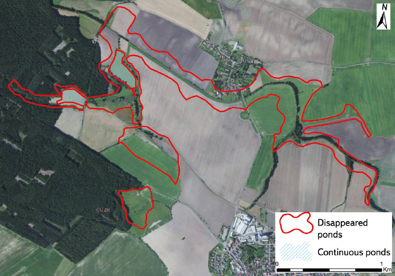
Fig. 10. Site of the disappeared Krčský and Štítarský ponds based on the current orthophoto map of the Czech Republic
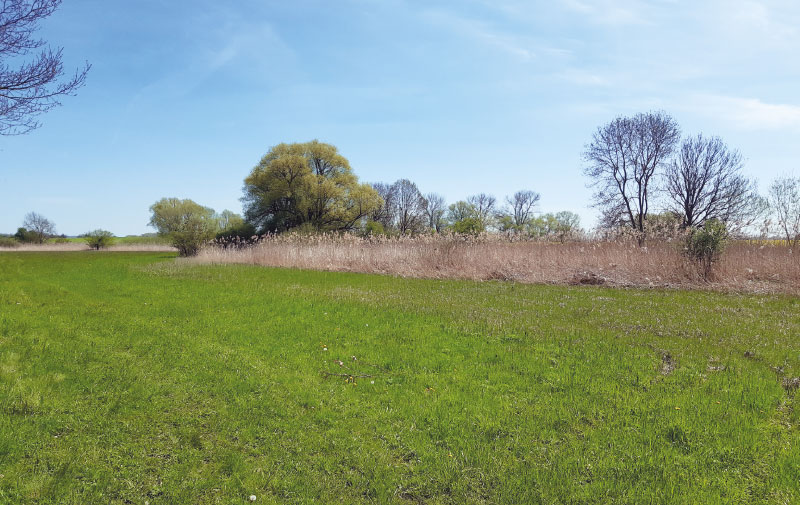
Fig. 11. Current state of the landscape at the site of the disappeared Štítarský pond near Městec Králové in Dymokursko NM (May 2023)
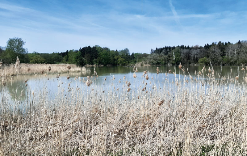
Fig. 12. Krčský pond (May 2022)
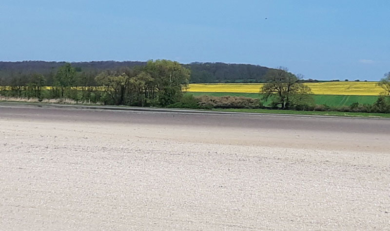
Fig. 13. Arable land, including waterlogged sites along the sites near Štítarský stream in the area of the disappeared Štítarský pond near Městec Králové (May 2023)
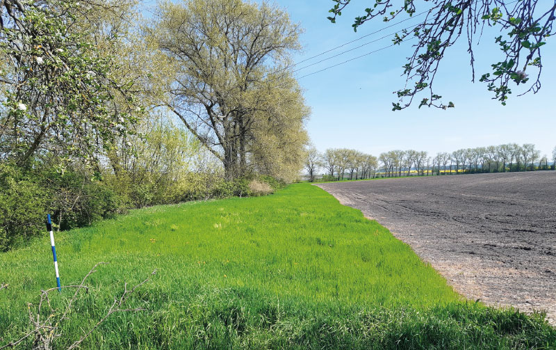
Fig. 14. Grassy strip along Štítarský stream in the area of thedisappeared Štítarský pond near the Vinice village (May 2023)
The current state at the site of the disappeared Záhorský and Kněžický ponds between Záhornice and Kněžice is presented in Figs. 15–17. At this site of disappeared ponds, there is a straightened and deepened watercourse of the Záhornický stream – here, however, with woody bank vegetation. It is one of the sites where ponds have mainly been replaced by arable land. There are signs of both seasonal waterlogging and flooding of arable land of such a nature that it practically makes use for growing crops impossible.
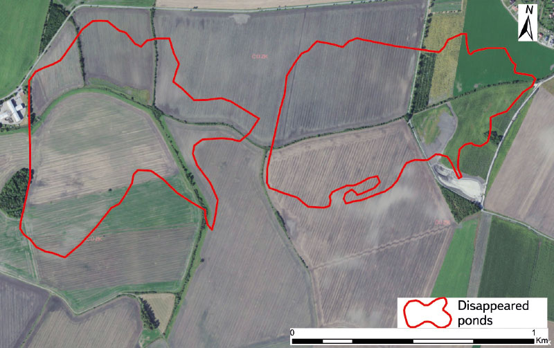
Fig. 15. Site of the disappeared Záhorský and Kněžický ponds based on the current orthophoto map of the Czech Republic
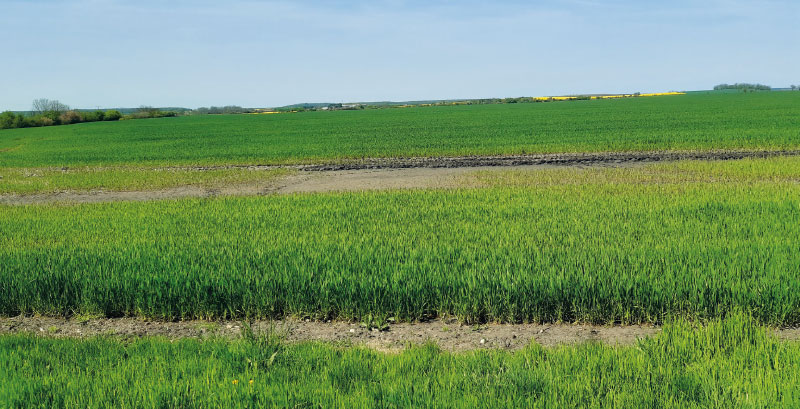
Fig. 16. Current state of the landscape at the site of the disappeared Kněžický pond, view towards the disappeared Záhorský pond (May 2023)
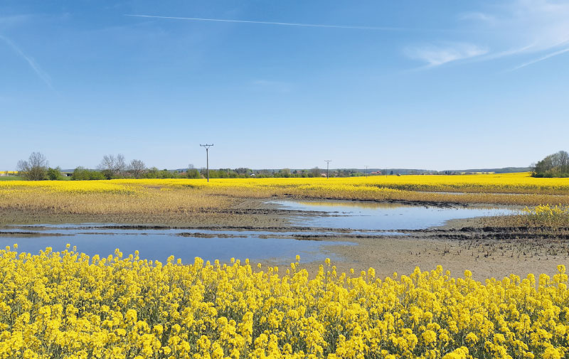
Fig. 17. Waterlogged site used as arable land at the site of the disappeared Kněžický pond (May 2023)
DISCUSSION
The results from the Poděbrady region regarding pond area according to stability do not correspond to the data for the entire Czech Republic, similarly to the Pardubice region [1]. In the Poděbrady region, from the mid-19th century to the present, disappeared ponds have the largest share – 58.26 % of the area of all ponds according to stability (906.96 ha), followed by continuous ponds with 38.22 % (595 ha), and the smallest area is occupied by new ponds at 3.52 % (54.81 ha). In the Pardubice region, from the mid-19th century to the present, disappeared ponds also have the largest share – 66.11 % of the area of all ponds according to stability (2,262.57 ha), followed by continuous ponds with 36.56 % (840.51 ha), and the smallest area is represent by new ponds at 13.4 % (319.29 ha). In contrast, data for the entire Czech Republic indicate the smallest area of ponds in the mid-19th century; since then it has been slightly increasing. This difference is probably due to the fact that in the lowlands there was generally pressure for another wave of pond desiccation only in the second half of the 19th century, although a large part of them had already disappeared from there earlier [1, 4–6, 9–11]. This is particularly evident from the documents of the First Military Mapping and Müller’s mapping. In Figs. 3, 4, and 5, this trend is also confirmed for the Poděbrady region, as it was previously for the Pardubice region [1].
However, compared to Poděbrady region, there is a noticeable change. While the largest ponds in Pardubice region, i.e. Velká Čeperka, Oplatil, Rozkoš, etc. (with the exception of the Rutvas pond) were still recorded on the maps of the Second Military Mapping, the largest Blato pond in the Poděbrady region is no longer recorded in these maps. This also applies to the other ponds of the historical Poděbrady and Nymburk pond system (Šumburk, Bobnický, Chlebský, Vestec, etc.) [4–6, 9, 10, 12]. This fact is also visible in Fig. 6 because, in the western part of the study area (near Poděbrady and Nymburk), there are no larger areas of historical ponds analysed according to the methodology presented here (i.e., from the Second Military Mapping). In Figs. 4 and 5, the areas of large ponds are shown both in the study area and just beyond its borders. Therefore, if only the area between Rožďalovice and Městec Králové (Fig. 6) was evaluated, the area of historical ponds would be similar to that of the Pardubice region [1].
As part of the evaluation of historical pond representation in Polabí, the part between Pardubice and Poděbrady was chosen as the one where their representation was the highest. Subsequently, this area was divided into two approximately equal parts, which were evaluated separately. From a hydrological point of view, however, this division was not the most ideal; part of the fourth order basin in Cidlina belongs to the Poděbrady region and part to the Pardubice region. However, if the location of the Cidlina river were taken into account, the area with the largest number of ponds in Polabí would have to be divided into three parts: the Pardubice region (Opatovický canal), Chlumec region (Cidlina), and Poděbrady/Nymburk region (Mrlina). However, this division is complicated by the Sánský canal, which connects Cidlina with Mrlina. Due to the size of both study areas and the locations of the respective fourth order basins, this division would not offer approximately the same areas, which would make it difficult to compare the results. In the sites of disappeared ponds, there is mainly arable land, permanent grasslands, and in Pardubice region also forests. Simultaneously, in places of historical ponds, in addition to waterlogged sites, there are small-scale protected areas on current arable land, which show the path that could be taken in the effort to transform the current landscape into a landscape that is more ecologically stable, reflecting its current state. In addition to Dymokursko NM, in the Poděbrady region there are, for example, Žehuňský rybník, Dlouhopolsko, and Kopičácký rybník national natural monuments (NNM), and Louky u Choťánek and Rybník Kojetín NM; in the Pardubice region, Bohdanečský rybník National Nature Reserve (NNR), and U Podhránovského rybníka NM [2, 7].
CONCLUSION
Given the current state of the landscape and ongoing climate change, it would be appropriate to use data on the location of disappeared ponds for landscape planning. This study can be used for the restoration of ponds in the places of their historical occurrence because it can be reasonably assumed that such locations are optimal in terms of landscape functional parameters and pond management. This could be justified especially where there is periodic waterlogging or flooding of locations currently used as arable land, and therefore it is not sensible – and in some places not even possible – to harvest the planted crop. Of course, it would not be a matter of restoring the original extensive ponds. It would be possible to build systems of small water bodies meeting the definition of a pond as one of the wetland types, including the occurrence of a littoral zone and with a corresponding maximum depth [13–15]. Another option is to at least plant hygrophilous trees in waterlogged areas, or leave these locations for succession.
Acknowledgements
This article was created as part of the TGM WRI internal grant No. 3600.54.03/2022 “Water in the landscape as an indicator of land changes in the Polabí lowland” and as part of research by the Centre for Landscape and Biodiversity (Technological Agency of the Czech Republic SS02030018).
The Czech version of this article was peer-reviewed, the English version was translated from the Czech original by Environmental Translation Ltd.
