ABSTRACT
In the past, the environment of the Czech Republic was contaminated with anthropogenic radionuclides as a result of atmospheric nuclear weapon testing and the Chernobyl accident. The paper summarises results of vertical migration of 137Cs in soil in selected sites, performed as part of collecting data for ground water vulnerability assessment. Three sites with a different land cover were included (forest, meadow and arable land). In order to determine vertical migration of anthropogenic radionuclides, soil samples were collected up to the depth of 100 cm and subsequently analysed using the gamma-ray spectrometry. Furthermore, certain soil properties (soil texture, humus content) were determined. The results show that 137Cs radionuclide contamination is still measurable in soil. The highest 137Cs activity in the three sites ranged between 21.0 Bq·kg-1 and 32.2 Bq·kg-1. These maximum values were detected in the top soil layer (up to 10 cm). Hence, 137Cs has a very slow migration rate and is mostly strongly bound in soil. However, a minor part of 137Cs can be transported deeper over time. The depth where 137Cs measurable activity was reached was estimated at 30 cm or 35 cm in two sites. The depth in the third site was even 80 cm. There are potential other impacts that could affect the transport of 137Cs. In terms of ground water vulnerability, it seems that ground water is fairly well protected from 137Cs penetration. This finding shall be verified by ground water analysis and evaluation of further data in the next project phase.
INTRODUCTION
Anthropogenic radionuclides arise as a result of human activities and with a few exceptions do not naturally occur in the environment. However, they may be introduced there by human activity [1]. Atmospheric nuclear weapon testing that started to be performed in 1945 had the greatest impact on the contamination of the Northern hemisphere by anthropogenic radionuclides. Following a treaty between the USA, UK and USSR, the tests were halted in 1963. According to UNSCEAR [2], a total of 540 atmospheric tests were performed with an overall output of 440 Mt. The total amount of radionuclides attributable to the global fallout is estimated at 622 PBq 90Sr and 948 PBq 137Cs (PBq=1015 Bq) [2]. More detailed data about the deposition of selected radionuclides as of 1990 are provided by Van der Stricht and Kirchmann [3].
The Chernobyl accident in today’s Ukraine was an event that caused the most significant radioactive contamination of the Czech Republic. The accident occurred on 26/4/1986 and radionuclide leaks continued until May 1986 [3–5]. The emission of radionuclides during the Chernobyl accident significantly contaminated the territory of the Czech Republic [6]. The Atlas [7] quotes total average spatial deposition of 137Cs in the Czech Republic including contamination following the atmospheric nuclear weapon testing of 7.6 kBq·m-2, deposition caused by the Chernobyl accident itself being 4.3 kBq·m-2 (the Report [8] states a mean value of 4.2 kBq·m-2). Chernobyl spatial contamination was differentiated according to the local meteorological situation, especially the occurrence of precipitation in the concerned period. Direct data about spatial deposition of 137Cs in the Czech Republic may be found in the Report [8].
At present, some of these radionuclides, in particular 137Cs and possibly also 90Sr, are still present in the environment not only in the vicinity of the Chernobyl power plant [1, 9–11] but also in more remote areas [12–16]. It has been observed that since the introduction of these radionuclides into the environment their amount has been gradually on the decline as a result of radioactive transformation of the monitored radionuclides and various migration phenomena. Radionuclide values in the Czech Republic are currently very low but still mea-surable [5, 13, 17–21].
It is clear from the above that residual contamination following atmospheric nuclear weapon testing and the Chernobyl nuclear reactor accident still remains in the Czech territory. The purpose of this paper has been to establish the current degree of contamination of the soil superstratum of underground aquifers and the depth that this contamination has reached in the vertical soil profile to date, primarily in order to be able to further evaluate ground water vulnerability.
METHODOLOGY
Vertical distribution of anthropogenic radionuclides in soil has been monitored in several sites, selected with a view to a broader context for further evaluation of ground water vulnerability. This paper presents results from three sites (Hatín, Krašlovice and Veltruby), each of which represents a different Corine Land Cover. In the Hatín site it was a coniferous forest, in Krašlovice a meadow and in Veltruby arable land. According to available data, the type of land cover in these sites has not changed since the Chernobyl accident [22–26]. Fig. 1 shows the selected sites on a map.
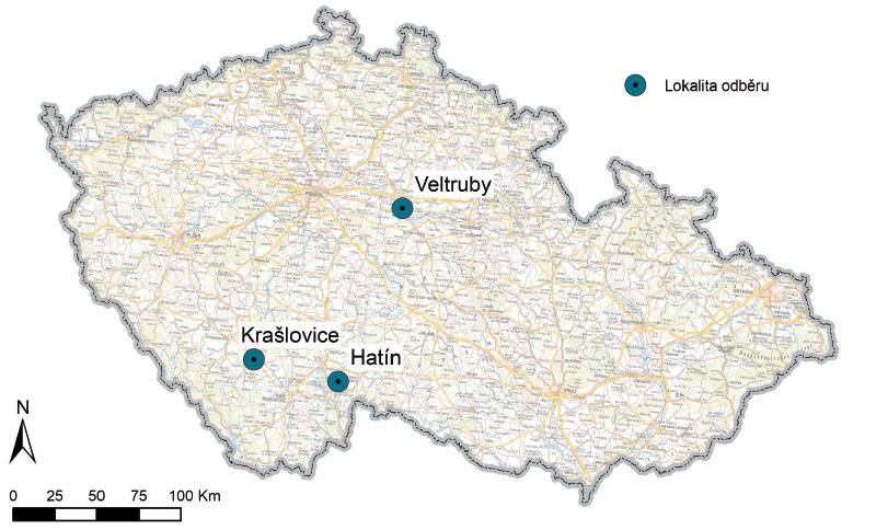
Fig. 1. Location of the soil sampling sites
The actual sampling in the given sites took place with the help of a soil probe by putting together 17 partial samples collected in the marked-out area (a square of 5 × 5 m). The sampling depth was 100 cm and individual samples were taken in 5-cm thick layers in the upper 50 cm of the soil profile and further down in 10-cm thick layers, as shown by Fig. 2. Following the collection, the samples were immediately transported to a lab where they were dried, homogenised and prepared for the determination of radionuclides.
The sampling and the subsequent analyses were performed by staff of the Testing Laboratory of Technologies and Environment Components of the TGM WRI, which holds an accreditation granted by the Czech Accreditation Institute (CIA) and a good laboratory practice certificate granted by the Centre for the assessment of laboratories ASLAB.
The gamma-ray spectrometry method was used to determine anthropogenic radionuclides in the lab; the analysis was carried out pursuant to the ČSN EN ISO 10703 (757630) technical standard [27] adjusted for solid samples, using Canberra Packard equipment with a coaxial semi-conductor detector of the HPGe type. The measurement geometry was verified by the Czech Metrology Institute standards. Measurement conditions (sample weight, measurement duration) were selected in such a way that the Minimum Detectable Activity (MDA) of 137Cs in the confidence interval α = β = 0.05 was 1.3 Bq.kg-1 or lower. The results were expressed in Bq·kg-1 of the dry matter of the sample. The following anthropogenic radionuclides were determined from the gamma radiation spectre: 57Co, 60Co, 134Cs, 137Cs and 241Am. However, only data concerning 137Cs were included in further evaluation because the remaining radionuclides were not detected in the samples. The MDA of these radionuclides was lower than 0.9 Bq·kg-1 (57Co), 1.7 Bq·kg-1 (60Co), 1.8 Bq·kg-1 (134Cs) and 4.0 Bq·kg-1 (241Am).
Besides, soil texture (sand, silt, clay) of the samples was determined in the lab in accordance with the ČSN EN ISO 17892-4 technical standard [28] and the results were evaluated according to the USDA [29]. Besides, the amount of oxidisable carbon (Cox) was determined in accordance with the ISO 14235:1998 standard [30]. Cox was converted to humus content using Welte’s coefficient.
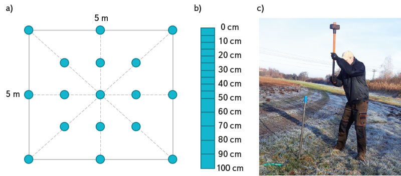
Fig. 2. Soil vertical profile sampling: a) Chart showing the collection of partial samples in a 5 × 5 m square; b) Illustration of sampling according to the depth; c) Use of sampling equipment (a soil probe) in the field
RESULTS AND DISCUSSION
Radionuclide 137Cs was detected in soil samples in all the three evaluated sites. Fig. 3 to 5 show detailed results of the determination of 137Cs in the vertical soil profile in the individual sites. The highest activity of 137Cs (amax (137Cs)) was established in layers closest to the surface. In Krašlovice and Veltruby it was in the upper 10 cm of soil and the measured values of 137Cs were similar in 0–5 cm and 5–10 cm, whereas in the Hatín site it was only in the upper 5 cm and then the activity significantly decreased. This is evidence of the fact that most of 137Cs is strongly bound in soil and is transported through its vertical profile only very slowly because at the time of the sampling approximately 35 years had passed since the last major deposition event. This is confirmed also by other papers dedicated to this topic, e.g. [15, 31]. The established results correspond with work previously carried out by the TGM WRI [32] that monitored 137Cs in the vertical soil profile in 1995 and in 2015.
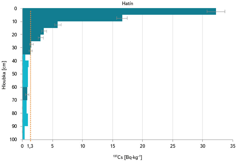
Fig. 3. 137Cs activity measured in the vertical soil profile in the Hatín site (the light blue colour stands for measured values below the MDA)
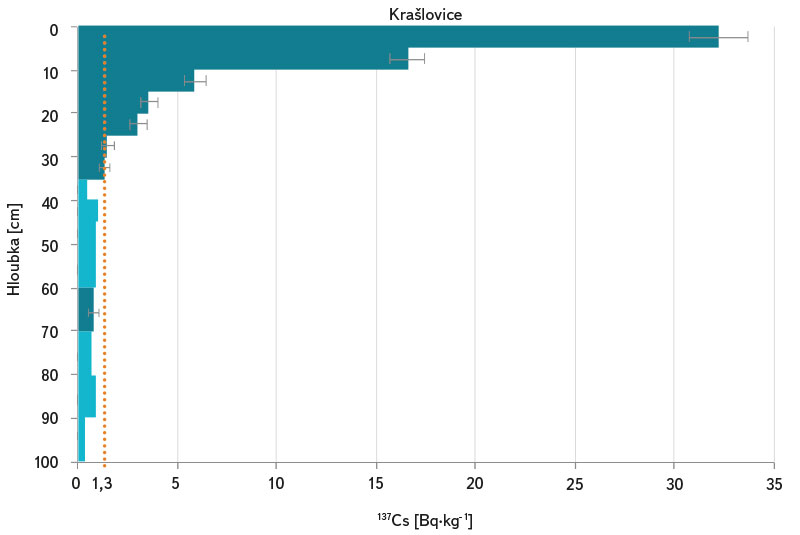
Fig. 4. 137Cs activity measured in the vertical soil profile in the Krašlovice site (the light blue colour stands for measured values below the MDA)
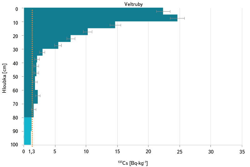
Fig. 5. 137Cs activity measured in the vertical profile in the Veltruby site (the light blue colour stands for measured values below the MDA)
Maximum activity of 137Cs in the individual sites was comparable (see Tab. 1) and so was average activity of 137Cs in the monitored soil layer calculated as arithmetic average of measured values higher than 1.3 Bq·kg-1 in the individual layers up to the depth of 100 cm, weighed on the basis of sampled layer thickness. This corresponds with available data [7] regarding the deposition of 137Cs in the individual sites after the Chernobyl accident where all the three sites were in the same range of estimated deposition of 137Cs after the Chernobyl accident (4–10 kBq·m-2); likewise according to [8]. The selected sites therefore match rather average Chernobyl fallout (according to [8], the mean fallout value after the Chernobyl accident stood at 4.2 kBq·m-2 in the Czech Republic whilst the maximum measured value stood at 80 kBq·m-2). The currently measured activity of 137Cs corresponds with results of an earlier study carried out by the TGM WRI [32].
Tab. 1. Summary evaluation of 137Cs activity in the vertical soil profile in the monitored sites: amax (137Cs) – maximum activity of 137Cs measured in the vertical profile; h-amax (137Cs) – depth of the layer where the maximum 137Cs activity was measured; aaver (137Cs) – average 137Cs activity in the monitored soil layer (up to the depth of 100 cm); H-a < 1.3Bq/kg (137Cs) – depth into which 137Cs contamination higher than 1.3 Bq·kg-1 penetrated
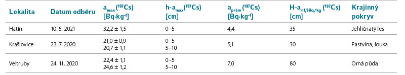
As regards the evaluation of vertical transport of 137Cs and assessment of ground water vulnerability, it is important what depth 137Cs contamination has reached in the soil profile. For the above reason, the depth with established 137Cs activity exceeding 1.3 Bq·kg-1 was evaluated. It may be stated that in the Krašlovice and Hatín sites the depth of 137Cs penetration was similar: 137Cs activity exceeding 1.3 Bq·kg-1 was established up to the depth of 30 or 35 cm. A significantly greater depth was established in the Veltruby site, namely 80 cm. Since the land cover in the Veltruby site comprises arable land, contamination may have been dispersed in the vertical profile as a result of tillage. It is clear from the bibliography [31] that vertical distribution of 137Cs in cultivated soil considerably differs from that in uncultivated soil. Where soil was cultivated by tillage, the upper soil layer is expected to have evenly distributed 137Cs activity due to mechanical mixing. However, since even in this site most of the contamination is concentrated in the top soil layer (the upper 10 cm) and then it drops, it may be presumed that this type of cultivation of the given plot of land did not take place (at the time of the sampling the site was covered by grass). This finding goes against the classification of the site according to the Corine Land Cover as arable land. Supplementary soil analysis also shows peculiarities of this profile, as stated below.
According to a specialised Soil Map [33], the soil type in all the three cases was determined as fluvial soil, which was locally confirmed by a soil probe. In the Krašlovice and Hatín sites there is modal fluvial soil whereas in the Veltruby sampling site there is gley fluvial soil. Fluvial soil develops in fluvial valleys from flood sediments and is occasionally flooded as a result of which soil humidity increases. Gley fluvial soil in the Veltruby site contains reductomorphic signs at the depth of 60 cm, which is evidence of regular profile saturation with water. However, permanent ground water level was not established in the sampling depth of any of the profiles. Soil type (USDA) in the Hatín site was determined as clay sand (sand content exceeding 80 %), in Krašlovice as sand clay (sand content exceeding 50 %) and in Veltruby as silt clay (silt content exceeding 50 %). The composition of soil texture in the monitored sites is shown by Fig. 6.
Humus content in soil in the Hatín site was very high in the upper horizons (22.6 % of humus in the depth of 0–5 cm); as the sampling depth increased, it evenly dropped to 0.77 % of humus in the depth of 90–100 cm. The measured values of 137Cs in the upper forest soil layer in the Hatín site roughly correspond to values established in forest humus in the paper [34] (with a view to humus content in the analysed soil). An even drop in humus content was noted also in the Krašlovice site where humus content was, however, significantly lower than in Hatín, yet it was high in the upper horizons (5.43 % at the depth of 0–5 cm and 0.28 % at the depth of 90–100 cm). Declining humus content linked to increasing soil depth is a standard phenomenon and that is why soil analysis results in the Veltruby site were interesting because humus content there was very high (9.43 %) at the depth of 0–5 cm and decreased in greater depths but then started to rise again in the depths of 80 to 100 cm and was higher than 12 %. Since the site is located in a flat area, it may be ruled out that this phenomenon would be caused by erosion and transport of material. A technical intervention into the soil profile or the impact of flooding and connected vertically changeable humus content in the flood soil layer seems to be a more plausible explanation. These possible events may also have had an impact on the distribution of 137Cs in this site. In order to explain this, a further survey of this site shall be necessary. Fig. 6 shows changes in humus content in vertical profiles of the assessed sites.
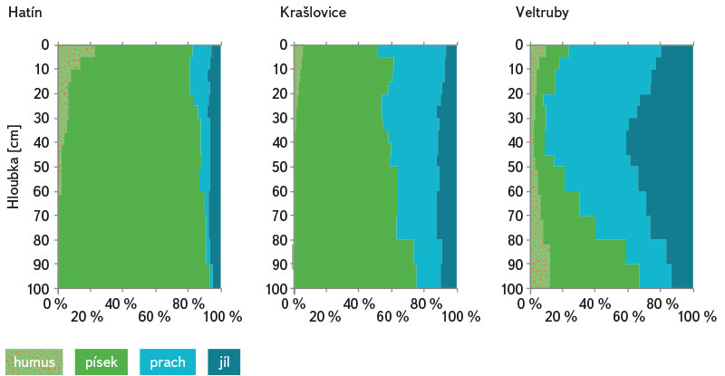
Fig. 6. Soil properties in the vertical profile in the monitored sites – soil texture (sand, silt, clay) and humus content
CONCLUSION
The results of monitoring vertical distribution of 137Cs in soil confirmed that soil contamination with this anthropogenic radionuclide in the Czech Republic is still measurable even though already 35 years have passed since the last major deposition event (the Chernobyl accident). Most of 137Cs activity is strongly bound in soil and the speed of its transport into deeper soil profile layers is therefore only very slow and most of established 137Cs activity is thus located in the top soil layer. In spite of that, contamination gradually penetrates into greater depths depending on local soil properties and other conditions; however, this activity is significantly lower than activity established at the surface.
As regards the evaluation of ground water vulnerability (its contamination with 137Cs), it may be said that most of 137Cs is captured by the top soil layer in the monitored sites and only a small amount of 137Cs may penetrate further. Further work shall focus on evaluating soil in other sites and on determining very low volume activities of 137Cs that could get to ground water as well as on evaluating the transport of 90Sr, which generally shows higher mobility in soil systems [35, 36].
Acknowledgements
This paper was written within project No. VI20192022142 entitled “Innovative Methods of Detecting Ultra-low Radionuclide Concentrations for the Purposes of Evaluating the Vulnerability of Drinking Water Sources during a Nuclear Accident” funded by the Ministry of the Interior of the CR within the framework of the Security Research Programme of the Czech Republic 2015–2022.
