

ABSTRACT
The Eurasian beaver (Castor fiber) is an important ecosystem engineer that alters the hydrological regime of the landscape through its activities. The aim of this study was to quantify the volume of surface water retained by beaver dams in the Czech landscape and to estimate the potential retention capacity of a selected catchment assuming the maximum predicted extent of beaver colonisation. The main focus of the research was to determine the volume of surface water accumulated behind 150 beaver dams at sites in the Plzeň Region (the Křemelná catchment and ten other selected wetlands) and the inundated area of the associated beaver ponds. GIS analyses based on a combination of precise geodetic data and a digital terrain model were used for the calculations. A beaver dam capacity model based on fuzzy logic principles and parameters such as stream slope, channel width, flow strength, and availability of riparian vegetation was also applied to the Chlístovický Stream catchment (fourth-order catchment, 13.8 km²) to estimate the amount of water that could realistically be retained by beaver dams in the study area assuming full colonisation of the catchment by beavers.
Field measurements showed that the 150 surveyed dams retain a total of 31,321 m³ of surface water, with 89 dams in the Křemelná catchment retaining 12,389 m³ across an area of 169 km². The distribution of retained volumes exhibits pronounced right-skewness (median 41.0 m³, mean 208.8 m³), confirming that the vast majority of dams retain relatively small volumes, while a small number of large beaver ponds account for a substantial proportion of the total retained volume – the largest 3 % of ponds account for 54 % of the total volume. A similar distribution pattern was observed for the inundated areas of beaver ponds, with a total area of 98,586 m². The median inundated area of an individual beaver pond was only 168.9 m², compared with a mean of 657.2 m², and the four largest ponds accounted for 53 % of the total inundated area. Modelling in the 13.8 km² Chlístovický Stream catchment identified nearly 6 km of watercourses suitable for beaver colonisation. Under full colonisation, the model predicts the formation of 13–43 dams. Based on the volumes measured at the experimental sites, surface water accumulation in the Chlístovický Stream catchment can be expected to amount to hundreds or several thousand cubic metres. A significant proportion of retention, however, also occurs below ground, further increasing the overall hydrological benefit. The formation of beaver ponds covering a total area of several thousand to tens of thousands of square metres could also provide an important ecological benefit by creating opportunities for the development of wetland habitats. The study demonstrates that beaver dams represent an important component of nature-based water retention in the landscape; however, their importance extends far beyond surface water accumulation. Beaver dams also contribute to sediment deposition, stabilisation of runoff patterns, and increased ecological stability of the landscape, and should therefore be given adequate space in the landscape.
INTRODUCTION
The Eurasian beaver is native to the European landscape and historically occupied extensive areas from the British Isles to eastern Siberia. Intensive hunting, however, brought it close to extinction, and by the end of the 19th century the European population was estimated at only about 1,200 individuals in eight isolated populations [1]. Species protection and reintroduction programmes have enabled its gradual return since the 20th century, and by around 2020 the European population was estimated at approximately 1.5 million individuals [2]. A similar development occurred in the Czech Republic, where, following its complete extirpation, the beaver was recorded again in 1977 at the confluence of the Dyje and Kyjovka rivers, and its population has grown rapidly since the beginning of the 21st century [3, 4]. In 2020, the population in the Czech Republic was estimated at approximately 15,000 individuals [5, 6].
Beavers are often described as ‘ecosystem engineers’ because of their ability to modify their environment by building dams [7]. As populations grow rapidly, this can lead to conflicts with people, but also produces a range of positive effects. A beaver dam is a structure made of natural materials that impounds a watercourse. A beaver pond forms upstream of the dam, comprising accumulated water that changes the character of the watercourse from flowing to standing water. Dams and ponds often form cascades that cause water to spread across the surrounding floodplain. These complexes subsequently form what is known as a beaver wetland (Figs. 1 and 2) [6, 8]. Although dams and the ponds they create primarily provide protection from predators and access to food [9], they also have a major influence on the hydrological regime of the landscape. They slow water flow, promote sedimentation, enhance interactions between surface water and groundwater, and increase surface water and groundwater storage [10–12].
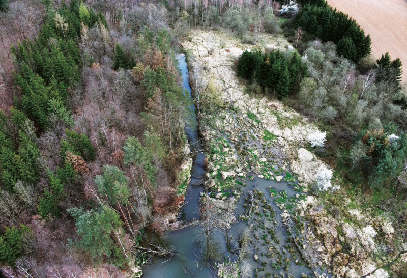
Fig. 1. Drone image of a beaver wetland on the Litohlavský stream, showing two beaver dams and associated ponds forming a cascade, and a wetland that developed on the right bank of the stream (photo: T. Laburda)
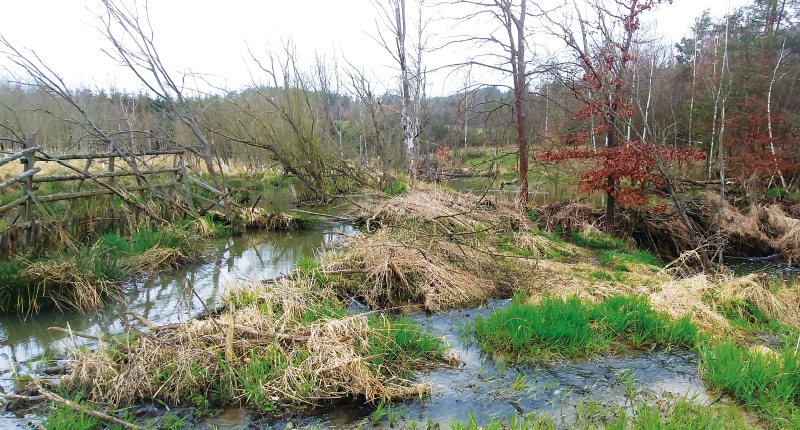
Fig. 2. Beaver wetland on the Litohlavský stream, viewed upstream; the main beaver dam (right, among the trees) has caused water to spread beyond the stream channel, creating a wetland (left and centre) (photo: A. Babuljak)
The benefits of beaver activity, however, extend beyond water retention alone. Dam building contributes to the restoration of near-natural river corridors and the natural structural diversity of floodplains, promotes the spontaneous renaturation of technically modified watercourses, and reduces the adverse effects of agricultural and forestry drainage systems [6, 13–15]. Newly created wetland habitats increase habitat diversity and biodiversity, aided by the fact that beaver activity increases the amount of ecologically valuable dead wood in watercourses [6, 13, 16, 17].
The principal focus of this study is to determine the volume of surface water retained by beaver dams. The vast majority of studies addressing this topic come from North America and show that beaver dams substantially increase the volume of water stored in watercourses and wetlands [18–20]. Beedle [18], for example, found that beaver ponds in Alaska retained up to 37 times more water than natural stream reaches, with individual pond volumes ranging from tens of cubic metres to more than 11,000 m³. Karran et al. [19] determined pond volumes of 1–9,001 m³ at four sites in North and South America. The few European studies available also confirm a substantial retention effect of beaver dams; for example, the total volume of water retained by 22 beaver dams in the Krzemianka catchment in Poland was estimated at 15,000 m³ [21].
In addition to retained volumes, this study also quantifies the inundated area of beaver ponds. This is important not only hydrologically but also ecologically, as larger beaver wetlands are associated with greater bird species richness and abundance and also increase the availability of lentic and littoral habitats within the floodplain [22, 23].
Although beaver behaviour and the development of their territories cannot be predicted reliably, certain parameters can be used to assess the suitability of an area for potential beaver colonisation [24]. Research has demonstrated relationships between beaver occurrence and watercourse characteristics such as slope, channel width, and the availability of riparian vegetation [25]. These findings have been used to develop spatial models that predict the capacity of the environment to support dam building [26]. Such models are also used to estimate potential water retention in the landscape. For example, a study in the Sierra Nevada, California, estimated that beaver dams could store up to 120 million m³ of surface water while also helping to increase landscape resilience to fire [27].
In this study, precise geodetic methods were used to determine the volume of surface water retained by 150 beaver dams in the Křemelná catchment and at ten other selected wetlands in the Plzeň Region, predominantly in the Šumava Mountains, with the aim of contributing quantitative evidence to assessments of the importance of beavers in the Czech landscape. The inundated area of the beaver ponds was also evaluated. At the same time, we modelled the potential number of dams that could develop in a selected fourth-order catchment following beaver colonisation, assuming minimal human restriction of beaver activity. These results were then used to quantify the amount of water that beavers could retain in the catchment through their activities.
The aim of the study was therefore to improve understanding of the positive effects of beaver colonisation by quantifying surface water retention in the landscape, which is one of the prerequisites for effective management of the Eurasian beaver and objective assessment of conflicts associated with its occurrence. Surface water retention is only one benefit of beaver dams and is linked to a range of other hydrological and ecological processes. In addition to retaining water and sediment, beaver structures can, for example, help sustain flows during dry periods, improve the microclimate, create valuable wetland habitats, and increase the amount of dead wood in watercourses [11, 18, 28].
METHODOLOGY
In the Křemelná catchment in the Šumava Mountains, a geographically and hydrologically coherent area containing 89 beaver dams at the time of the survey in spring 2023, and at ten selected beaver wetlands in the Plzeň Region, precise field surveying was used to determine the volumes of surface water retained by the dams and the inundated areas of the beaver ponds. In the Chlístovický Stream catchment, the potential occurrence of beaver dams was also modelled according to the suitability of individual watercourse reaches for dam construction.
Study areas
The study covered three areas, shown in Fig. 3. Field measurements and determination of the actual volumes of water retained by beaver dams and the inundated areas of their ponds were carried out at 89 beaver dams in the Křemelná catchment and at ten beaver wetlands in the Železná Ruda area, on the Úslava river, and on the Voldušský stream.
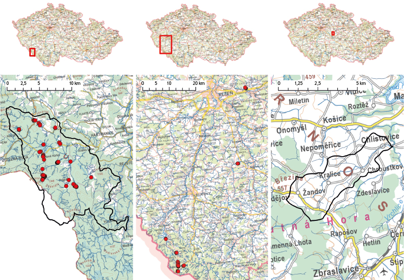
Fig. 3. Study areas – left: Křemelná catchment; centre: ten selected beaver wetlands in the Plzeň Region; right: Chlístovický catchment (basemaps: Basic Topographic Map of the Czech Republic, Czech Office for Surveying, Mapping and Cadastre; ČÚZK)
The Křemelná catchment was selected in cooperation with Šumava National Park for the study Field measurement and mapping of beaver dams in the Křemelná catchment [29] as an example of a landscape in which the presence of beavers is subject to only minimal human restriction. All known beaver dams in the catchment were examined, from small ponds within watercourse channels to extensive ponds forming wetlands on stream floodplains. The research in the Křemelná catchment therefore provided a comprehensive picture of the characteristics of beaver dams and ponds at the regional scale.
The ten selected wetlands in the Plzeň Region were chosen in cooperation with the Nature Conservation Agency of the Czech Republic (NCA CR) for the study Effects of beavers on river-landscape ecosystems [30] as examples of areas representing the target state of development of a watercourse and its immediate surroundings following beaver colonisation. The wetlands contain varying numbers, types, and sizes of beaver dams and associated ponds, although on average the ponds are generally larger than those in the Křemelná catchment.
The third area, the Chlístovický Stream catchment, was used to model beaver dam capacity. This work was carried out as part of the project Water systems and water management in the Czech Republic under climate change, in which the Chlístovický Stream catchment was already being used for other modelling of landscape water retention and rainfall–runoff relationships and was therefore also selected for modelling potential beaver dam capacity.
Křemelná catchment
Surveying and determination of the actual volume of water retained by beaver dams and the inundated areas of beaver ponds were carried out in the Křemelná River catchment in Šumava National Park. The study area, whose principal watercourse is the Křemelná river, more than 30 km long, lies in the north-western part of the park, predominantly within the Czech Republic but extending marginally into Germany. The catchment has a total area of approximately 169 km², corresponding to about one quarter of the area of Šumava National Park.
Orographic conditions result in long-term above-average precipitation totals in the catchment (the Prášily rain-gauge station recorded mean annual precipitation of 1,413.7 mm in 1991–2020 period), resulting in abundant water and a dense hydrographic network. This includes both torrential reaches in incised mountain valleys and small meandering watercourses on upland plateaus.
Thanks to the high level of protection and historically limited human activity, the watercourses and their floodplains have retained a relatively natural character. These conditions provide suitable habitat for the Eurasian beaver, whose population is thriving and whose activities further increase the water-retention capacity of the landscape.
The Šumava National Park Administration has conducted long-term monitoring of Eurasian beaver activity in the area. Data from this monitoring were used to identify sites containing beaver dams, which were subsequently surveyed in the field.
One of the beaver dams in the Křemelná catchment near the settlement of Mechov is shown in Fig. 4.
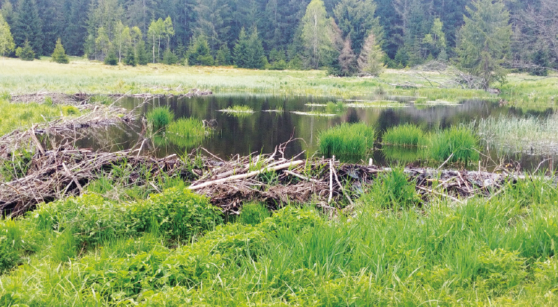
Fig. 4. One of the largest beaver dams and associated ponds in the Křemelná catchment, forming part of the wetland near the settlement of Mechov (photo: A. Babuljak)
Ten beaver wetlands in the Plzeň Region
Actual volumes of water retained by beaver ponds were also determined at ten selected beaver wetlands in the Plzeň Region. Eight were selected around Železná Ruda, in the Řezná and Úhlava catchments, the latter adjoining the Křemelná catchment. These wetlands lie outside the national park and are more affected by human activity than sites in the Křemelná catchment, although nature conservation is strengthened by their location within the Šumava Protected Landscape Area.
The remaining two wetlands studied were on the Úslava River near the village of Prádlo and on the Voldušský stream near Litohlavy. Both sites lie outside protected areas in a typical Czech agricultural landscape. While the wetland on the Úslava developed in open countryside, the wetland on the Voldušský stream is partly within woodland. The ten wetlands studied contained a total of 61 individual beaver ponds, often directly adjoining one another.
One of the four dams forming the beaver wetland on the Úslava river is shown in Fig. 5.
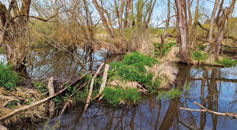
Fig. 5. One of the four dams that make up the beaver wetland on the Úslava river near the village of Prádlo (photo: A. Babuljak)
Chlístovický Stream catchment
Potential beaver dam occurrence was modelled in the Chlístovický Stream catchment. This is a fourth-order catchment covering 13.8 km² and is predominantly agricultural in character. It is located in the Central Bohemian Region near the village of Malešov. The principal watercourse is the Chlístovický stream, a left-bank tributary of the Vrchlice river, which it joins near Malešov approximately 3 km upstream of the upstream boundary of the Vrchlice Reservoir.
Evaluation of retained volumes and inundated areas
The volume of water retained by existing dams at the experimental sites and the inundated area of the beaver ponds were determined by analysing the geodetic survey outputs using GIS tools.
Surveying
Geodetic surveying of beaver dams and ponds in the Křemelná catchment was carried out in spring 2023, while the beaver wetlands in the Železná Ruda area, on the Úslava river, and on the Voldušský stream were surveyed in spring 2024 and 2025. Three high-precision GPS instruments were used. Emlid Reach RS+ and Emlid Reach RS2 GPS receivers were used at all sites, with a CHC X91 GPS receiver additionally used in the Křemelná catchment.
A total of 89 beaver dams and their inundated areas were surveyed in the Křemelná catchment. For the great majority of dams, three points on the dam were surveyed (left abutment, right abutment, and centre of the crest), together with the channel bed downstream of the dam, the pond depth upstream of the dam, and the upstream boundary of inundation. Several dams with complex pond shapes or dam alignments were surveyed in greater detail.
For five selected dams, the ponds, including water depths, were also surveyed in detail to validate the GIS method used to determine retained volumes (Fig. 6). A total of 1,445 points were surveyed in the Křemelná catchment.
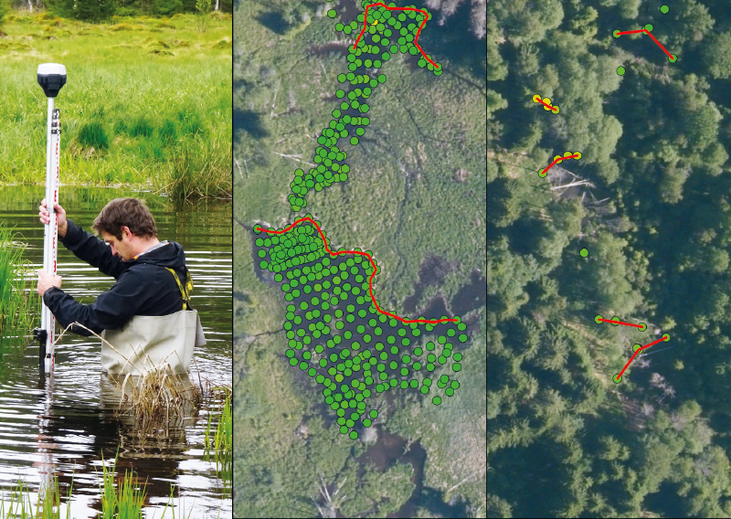
Fig. 6. Surveying of beaver ponds and dams – left: GPS-based surveying and water-depth measurement; centre: detailed survey of a beaver pond; right: simplified survey of beaver dams and inundation boundaries (photo: J. Uhlíková; basemap: Orthophoto of the Czech Republic, Czech Office for Surveying, Mapping and Cadastre; ČÚZK)
At the ten selected wetlands in the Železná Ruda area, on the Voldušský stream, and on the Úslava river, a total of 61 beaver dams and their inundated areas were surveyed. Dam polylines, inundation boundaries, and water depths in the ponds were measured. Owing to the morphological conditions, these were generally larger ponds than those in the Křemelná catchment. A total of 3,716 points were surveyed at these sites.
GIS tools
Based on the field GPS measurements described in the previous section, GIS analyses were applied at the two experimental study areas to determine the volume of water retained by beaver dams. The approaches used share the principle of combining precise geodetic data with a digital terrain model (DTM), while their specific implementation was adapted to the characteristics of the individual sites and the data available.
For the 89 dams surveyed in the Křemelná catchment in spring 2023, a GIS-based volume-determination method was used that combined beaver dam lines surveyed by high-precision GPS with a detailed digital terrain model representing conditions before the ponds formed. Dam lines were derived from the geodetic survey, and a high-accuracy, fine-resolution DTM capturing pond-bed morphology was used (a 50 × 50 cm LiDAR DTM from 2017, produced for Šumava National Park by German partners as part of a joint cross-border project).
In the GIS environment, the dam lines were converted to raster format and used to determine the water level in each inundated area as the highest terrain elevation along the beaver dam line (usually at the left or right dam abutment). The contributing catchments were then delineated so that individual ponds could be assessed separately even where they immediately adjoined one another in cascades. The extent of each inundated area was subsequently defined as the intersection between the contributing catchment and areas with terrain elevations below the specified water level.
Volume was calculated by comparing the water-surface elevation with the digital terrain model within the delineated inundated area, from which the spatial distribution of water depths was derived. Total water volume was then calculated as the sum of the partial volumes corresponding to individual raster cells. The procedure was implemented as a Python script in ArcGIS Pro, enabling efficient processing of a large number of dams and generation of accompanying raster outputs.
The method was validated using detailed geodetic surveys of five dams. For these dams, water depths within the inundated area and the perimeter and crest of the dam were surveyed in detail. Volume was calculated using the Thiessen polygon method and compared with the value obtained from GIS analysis of the dam lines and terrain model. The comparison confirmed that the method was suitable for determining the volume of surface water retained by beaver dams.
The method was modified slightly to determine the volume retained by the 61 dams within beaver wetlands in the Železná Ruda area, on the Úslava river, and on the Voldušský stream, for two reasons. First, at some of these sites the dams had created extensive wetlands with several water-surface levels across the wetland floodplain, which the original method could not represent. Second, the inundation boundaries and water depths had been surveyed in greater detail, and the aim was to incorporate these values into a more accurate calculation. To make optimal use of the survey outputs and account for variable water levels, a modified method was applied combining point measurements of water depth with the 1 × 1 m DMR 5G digital terrain model.
Water-surface elevation at individual points was derived from the measured depths and corresponding elevations in the digital terrain model and was then interpolated into a continuous water-surface raster. Comparing this surface with the terrain model yielded the spatial distribution of water depths and subsequently the water volume and inundated area of individual ponds. The method thus maintains high accuracy where direct measurements are available while minimising uncertainties in sparsely surveyed areas where terrain is difficult to access or water is too deep for the survey team to work safely.
Modelling potential beaver dam occurrence
Based on models developed abroad, a beaver dam capacity model adapted to Czech data sources was created in ArcGIS Pro. The model classifies individual watercourse reaches according to the potential number of beaver dams that could develop following colonisation. Each reach is assigned a category together with an estimate of the minimum and maximum expected number of dams.
The beaver dam capacity model used for the Chlístovický Stream catchment is based on a British model derived from the American BRAT (Beaver Restoration Assessment Tool) model. The American model was developed by a research team led by William W. Macfarlane [26], subsequently validated repeatedly at several sites in North America [14, 31], and used in numerous studies [27, 32, 33]. For European conditions, the model was adapted by a team led by Hugh A. Graham of the University of Exeter [24], and the model applied to the Chlístovický Stream catchment is based on this adaptation.
Graham et al. [24] present the BFI (Beaver Foraging Index) and BDC (Beaver Dam Capacity) models, which were developed, validated, and applied in the British catchments of the Tay, Otter, and Coombeshead. The BFI model classifies the availability of vegetation for food and dam construction in two key zones: immediately adjacent to the bank (10 m) and within a wider riparian zone (40 m). BFI outputs are subsequently used as one of the inputs to the BDC model, which also analyses longitudinal channel slope and stream power at both low (Q80% – 80% quantile) and high (Q2% – 2% quantile) flows, thereby assessing the ability of beavers to build dams and the dams’ potential resistance to floods. The model integrates these variables using a fuzzy inference system (FIS). The principal BDC output is a classification of reaches into theoretical maximum-capacity categories expressed as ranges in the number of dams per kilometre of watercourse.
Graham et al. [24] validated the model by comparing its predictions with field-survey data covering 258 km of watercourses and 89 identified beaver dams.
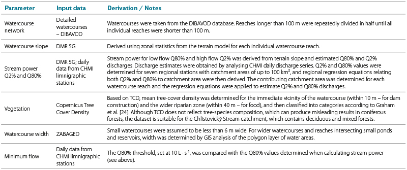
The model used for the Chlístovický Stream catchment retains the same parameters and fuzzy-logic principles as the British model but differs in its input data, some of which in the original version were specific to Great Britain. A further modification was the introduction of two threshold values: maximum watercourse width and minimum Q80% flow. According to Hartman et al. [34], beavers build dams almost exclusively on watercourses less than 6 m wide. Although watercourses of this width do not occur in the Chlístovický Stream catchment, the threshold serves to exclude small ponds and reservoirs. The second threshold was minimum flow, reflecting the fact that beavers build dams only on perennial watercourses, whereas intermittent watercourses are unsuitable. Watercourse reaches that failed to meet either threshold were automatically classified by the model as ‘none’, i.e. with zero capacity for beaver dam construction. The individual parameters and input data used are summarised in Tab. 1.
Tab. 1. Input parameters for the beaver dam capacity model
Application of the beaver dam capacity model divided individual watercourse reaches in the Chlístovický Stream catchment into four categories according to the potential density of beaver dams following colonisation of the catchment. Each category represents a range between the minimum and maximum number of beaver dams per kilometre that can be expected following beaver colonisation of a watercourse. The resulting categories and ranges of expected beaver dam density were adopted from Graham et al. [24] and MacFarlane et al. [26]:
- Frequent – capacity of 5–15 beaver dams per kilometre of watercourse;
- Occasional – capacity of 1–4 beaver dams per kilometre of watercourse;
- Rare – capacity of 0–1 beaver dam per kilometre of watercourse;
- None – capacity of 0 beaver dams per kilometre of watercourse.
RESULTS
Actual volume retained by beaver dams at the experimental sites
The 150 beaver dams at the experimental sites retain a total of 31,321 m³ of water. Measurements of the volumes of surface water retained by the dams show a strongly right-skewed distribution with high variability. Mean volume is 208.8 m³, median volume 41.0 m³, and the standard deviation 681.5 m³, demonstrating considerable variation in beaver pond size. Recorded volumes range from 0.02 to 6,583 m³. High skewness (6.83) and kurtosis (53.78) confirm the pronounced asymmetry of the distribution and the presence of extreme values, while a normality test showed a statistically significant departure from a normal distribution (p < 0.001).
The largest pond forms part of the beaver wetland on the Úslava river and retains 6,583 m³ of water. The entire wetland, formed by four dams, stores a total of 9,991 m³ of water. The distribution of water depths within this wetland is shown in Fig. 7.
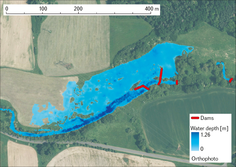
Fig. 7. Water depths in a beaver wetland on the Úslava river formed by four dams and their associated beaver ponds (basemap: Orthophoto of the Czech Republic, Czech Office for Surveying, Mapping and Cadastre; ČÚZK)
The data show that most beaver dams retain relatively small volumes of water, while only a small number of sites accumulate substantially larger volumes and have a major influence on the overall distribution of the data.
Figs. 8 and 9 show that the five largest ponds, representing 3 % of the total number, stored 54 % of the total water volume. Conversely, the smallest 80 % of ponds, each with a capacity of up to 200 m³, retained only 15 % of the total volume.
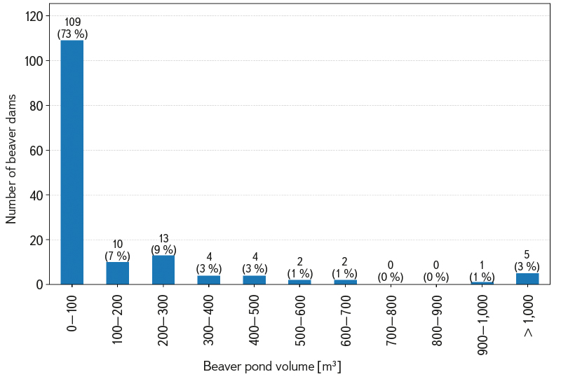
Fig. 8. Water volumes retained by beaver dams at the experimental sites
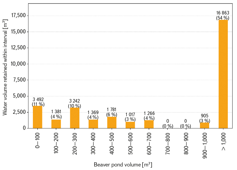
Fig. 9. Contribution of different pond size classes to the total retained volume
This pattern is accentuated by the inclusion of several extensive beaver wetlands, particularly the wetland on the Úslava river. It nevertheless remains pronounced when the dataset is restricted to the Křemelná catchment, a geographically and hydrologically coherent area in which retained volumes were determined for all known beaver dams. Here too, the dataset of 89 dams shows a strongly right-skewed, non-normal distribution. Mean volume is 139.2 m³, median volume 33.9 m³, and the standard deviation 404.9 m³. Skewness (6.14) and kurtosis (41.27) again confirm the strong asymmetry of the data and the influence of several extreme values.
In the Křemelná catchment, the largest pond accounts for 26 % of the total retained volume, specifically 3,274 m³ out of 12,389 m³. The largest 10 % of dams retain approximately two thirds of the total water volume. On average, beaver dams in the Křemelná catchment retain 73.3 m³ of water per square kilometre of catchment area.
The results show that the great majority of dams at the experimental sites retain only small volumes of water: 73 % of dams had pond volumes of 0–100 m³. These volumes are not substantial in terms of the overall total. Instead, a small proportion of extensive ponds that store thousands of cubic metres of water plays the decisive role. Although small ponds make only a limited contribution to total retained volume, they may be highly important for biodiversity and the other related aspects discussed above.
Inundated area of beaver ponds at the experimental sites
The 150 beaver dams at the experimental sites create a total inundated area of 98,586 m². As with retained water volumes, the inundated areas of the beaver ponds show a strongly right-skewed distribution, dominated by smaller ponds with a small number of extremely extensive ponds. Mean inundated area is 657.2 m², whereas the median is only 168.9 m², with recorded values ranging from 0.5 to 27,941 m². High skewness (8.84) and kurtosis (85.73) confirm the strong influence of extreme values on the distribution; compared with retained water volumes, the higher values of these statistics indicate an even greater dominance by a few very extensive beaver ponds. The distribution of inundated beaver pond areas is clearly shown in Fig. 10.
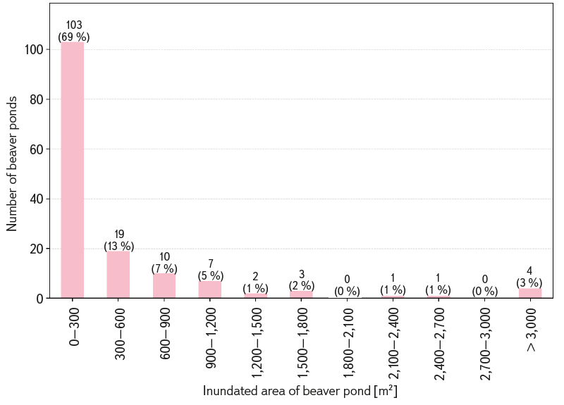
Fig. 10. Inundated areas of beaver ponds at the experimental sites
The largest inundated area was recorded for the same pond on the Úslava river that also had the greatest retained water volume, reaching 27,941 m². The entire beaver wetland, formed by four beaver dams, has a total inundated area of 41,740 m², representing more than 40 % of the total inundated area in the dataset (the Úslava river wetland shown in Fig. 11).
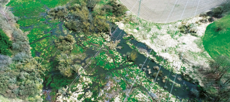
Fig. 11. Beaver wetland on the Úslava river, which accounts for more than 40 % of the total area of all 150 beaver ponds (photo: T. Laburda)
The results show that, as with retained water volumes, the total inundated area is strongly influenced by a few of the largest ponds. The four largest ponds, each with an inundated area exceeding 4,000 m² and representing only 2.7 % of the sites studied, account for 53 % of the total inundated area.
This pattern remains evident when the dataset is restricted to the Křemelná catchment. As in the full dataset, the 89 beaver ponds show a strongly right-skewed, non-normal distribution. However, skewness (5.69) and kurtosis (39.40) are lower than in the full dataset, reflecting the absence of several extremely extensive sites, particularly the beaver wetland on the Úslava river. Mean inundated area is 379.6 m², the median 137.8 m², and the total inundated area of all surveyed ponds in the Křemelná catchment is 33,785 m².
The largest pond in the Křemelná catchment has an inundated area of 6,639 m² and accounts for approximately 20 % of the total inundated area of beaver ponds in the catchment. The nine largest ponds, representing 10 % of sites in the Křemelná catchment, account for 54 % of the total inundated area. In the full dataset, a similar proportion is accounted for by only the four largest ponds. The mean inundated area of beaver ponds in the Křemelná catchment is approximately 200 m² per square kilometre of catchment area.
Modelling potential beaver dam capacity on watercourses in the Chlístovický Stream catchment
All watercourse reaches in the Chlístovický Stream catchment were classified into four categories according to the potential number of beaver dams per kilometre of watercourse. The resulting classification of individual reaches is shown in Fig. 12.
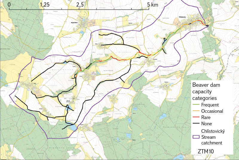
Fig. 12. Classification of watercourses according to beaver dam capacity in the Chlístovický potok catchment (basemap: Basic Topographic Map of the Czech Republic, Czech Office for Surveying, Mapping and Cadastre; ČÚZK)
After all watercourses in the catchment (the Chlístovický stream and all its tributaries) had been divided into reaches with a maximum length of 100 m, 274 watercourse reaches with a total length of 23.1 km were identified. The catchment contained:
- 28 watercourse reaches classified as frequent, with a total length of 2,200 m and a capacity of 11–33 beaver dams;
- 27 watercourse reaches classified as occasional, with a total length of 2,225 m and a capacity of 2–9 beaver dams;
- 17 watercourse reaches classified as rare, with a total length of 1,540 m and a capacity of 0–2 beaver dams;
- The remaining 202 watercourse reaches, with a total length of 17.1 km, were classified as none. These reaches are unsuitable for beaver dams.
Overall, the model identified almost 6 km of watercourses in the catchment as suitable for beaver colonisation and dam construction. Under full colonisation of the catchment, beavers could build 13–43 dams.
Our evaluation of the surface water volumes retained by 150 beaver dams at the experimental sites in the Křemelná catchment and wetlands in the Plzeň Region can be used to estimate how much water potential beaver dams in the Chlístovický Stream catchment might retain and the extent of inundation they might create. It should be emphasised, however, that these estimates are based on the characteristics of beaver ponds in areas different from the catchment for which the estimates are being made.
Using the median retained volume, rounded to 40 m³, 13 beaver dams would retain approximately 520 m³ of water, while 43 dams would retain 1,720 m³. Using the mean retained volume, rounded to 200 m³, and assuming that several larger beaver ponds develop in the catchment, 13 dams would retain 2,600 m³ of water and 43 dams as much as 8,600 m³.
Similarly, using the median value from the Křemelná catchment and the ten wetlands in the Plzeň Region, it can be estimated that 13–43 beaver ponds in the Chlístovický Stream catchment would create a total inundated area of approximately 2,200–7,200 m². Assuming the development of several larger ponds and using the mean inundated area, the total could reach 8,500–28,000 m².
The broad ranges between the limiting values of expected volumes result from the nature of the beaver dam capacity model used, but also reflect the variability and irregularity characteristic of beaver ponds. The estimates could probably be refined by geomorphological analysis of the area, but the outcome of beaver activity at any particular site is always unique and cannot be predicted precisely. Beaver colonisation of the Chlístovický Stream catchment can therefore be expected to result in several tens of beaver dams, creating surface water storage of several thousand cubic metres and inundating several thousand to several tens of thousands of square metres. Given the catchment area of 13.8 km², this would correspond to several hundred cubic metres and several hundred to a few thousand square metres per square kilometre of catchment area.
DISCUSSION
We investigated the volume of surface water retained by beaver dams in the Czech landscape. The 150 dams studied in the Plzeň Region retained 31,321 m³ of surface water, with a mean pond volume of 208.8 m³ and a median of 41.0 m³. Compared with published studies from North American sites, the beaver ponds in this study had substantially lower volumes: only 3 % of the dams studied retained more than 1,000 m³ of water and most ponds had volumes of up to 200 m³, whereas pond volumes in North American studies are generally in the order of several thousand cubic metres. Much higher values were reported, for example, by Burns and McDonnell [35], who quantified the volume of one beaver pond at 7,500 m³, and Westbrook et al. [20], who determined a total volume of 18,992 m³ for four ponds at Sibbald fen. In a survey of 44 dams in Alaska, Beedle [18] found a mean pond volume of 1,020 m³, with values ranging from 10 to 11,400 m³. Although mean volumes were higher than in our dataset, the distribution was consistent with our results: retained volumes were strongly right-skewed, with several extremely large ponds. European studies, by contrast, provide values more comparable with our results. Puttock et al. [36] determined a total volume of approximately 1,000 m³ for 13 dams in south-east England, while Grygoruk et al. [21] estimated a retention volume of 15,000 m³ for 22 dams in Poland’s Krzemianka catchment; after beaver activity declined and the number of dams fell to 19, pond volume decreased to 7,000 m³. This also illustrates that retained volumes change over time as beaver wetlands develop, with the duration of colonisation and with increases or decreases in beaver activity at a site.
The inundated areas of beaver ponds showed a pattern similar to that of retained water volumes. A total area of 98,586 m², with a mean of 657 m² and a median of 169 m², shows that most beaver ponds create only relatively small inundated areas, while a few extensive ponds have a major influence on the overall total. This effect was even more pronounced for inundated area than for retained water volume: the four largest ponds, representing 2.7 % of all sites, accounted for more than half of the total inundated area.
Modelling in the Chlístovický Stream catchment showed that beavers could potentially build 13–43 dams. Based on the volumes determined in this study in the Křemelná catchment and at the ten other beaver wetlands in the Plzeň Region, these dams could be expected to store approximately 520–1,720 m³ of water using the median pond volume, or as much as 2,600–8,600 m³ using mean values that allow for the development of several larger ponds. These values represent only surface water storage, whereas a substantial proportion of retention also occurs within the soil. Dittbrenner et al. [37] and Hafen et al. [38] estimate that an additional 2–2.4 times the volume of surface water retained by beaver dams is stored below ground. In the Chlístovický Stream catchment, groundwater storage could therefore increase by up to approximately 20,000 m³.
In addition to the volume of water retained, beaver dams would also enhance the ecological value of the area by increasing the extent of open water [22, 23]. Using the values determined in this study, the total inundated area of beaver ponds in the Chlístovický Stream catchment can be estimated at approximately 2,200–7,200 m² using median values and up to 8,500–28,000 m² using mean values and assuming the development of several larger ponds.
Beaver dams also have a significant effect on sediment transport. Dams slow water flow and create conditions for sediment deposition, with published sedimentation rates varying greatly according to site characteristics – from 0.4 cm · year-1 according to Polvi et al. [12] in the Rocky Mountains to 28 cm · year-1 in Montana [39]. Assuming a total pond area of 2,200–28,000 m² in the Chlístovický Stream catchment, this could very approximately result in the deposition of tens to, under an extreme scenario, a few thousand cubic metres of sediment per year. The magnitude of this process, however, depends strongly on catchment characteristics, sediment production, and hydrological conditions.
Although this study focused on quantifying the volume of surface water retained by beaver dams, their retention effect represents only one aspect of their influence. As published studies have shown, beaver activity has a substantial effect on a range of hydrological and ecological processes, including the renaturation of watercourses and floodplains, reduction of the effects of historical drainage systems, increased habitat diversity and amounts of wood in watercourses, and enhanced biodiversity [6, 13–15, 17].
CONCLUSION
Our study quantified the volume of surface water retained by 150 beaver dams at experimental sites in the Czech landscape and assessed the potential occurrence of beaver dams in the Chlístovický Stream catchment as a model catchment in a conventionally managed agricultural landscape in Central Bohemia.
The total volume of surface water retained by beaver dams at the experimental sites exceeded 31,000 m³. The distribution of volumes was highly uneven: the median was 41.0 m³, whereas the mean reached 208.8 m³. More than half of the total water volume (54 %) was retained by only the five largest ponds, while the smallest 80 % of ponds together stored just 15 % of the total volume. In the Křemelná catchment, beaver dams retained 73.3 m³ of surface water per square kilometre.
Comparison with studies from other countries showed that beaver pond volumes under Czech conditions are generally lower than at North American sites, although their distribution is similar. This comparison suggests that the retention capacity of beaver dams depends not only on local geomorphological and hydrological conditions but also on other factors, such as the duration of beaver colonisation and the amount of space people allow beavers in the landscape.
Like retained water volumes, the inundated areas of beaver ponds were also highly unevenly distributed. The total inundated area exceeded 98,000 m², but 53 % of this was accounted for by only the four largest ponds. Median inundated area was just 168.9 m² compared with a mean of 657.2 m², indicating, as with retained water volumes, the high heterogeneity of beaver ponds, driven primarily by differences in local site conditions.
Modelling potential colonisation of the Chlístovický Stream catchment showed that its 13.8 km² area contains approximately 6 km of watercourses suitable for beaver dam construction. Under full colonisation, 13–43 beaver dams could develop. Based on the volumes determined at the experimental sites, surface water storage of hundreds to several thousand cubic metres can be expected. Available evidence also suggests that the overall retention effect may be greater because of groundwater storage, which represents an important component of water retention in beaver wetlands. Based on the inundated areas of beaver ponds, it can additionally be estimated that the dams would inundate several thousand to several tens of thousands of square metres, thereby enhancing the ecological value of the area. Beaver dams are also associated with other benefits, particularly sediment deposition, support for wetland habitats, stabilisation of runoff patterns, and increased ecological stability of the landscape.
The results confirm the important role of the Eurasian beaver as an ecosystem engineer capable of substantially altering the hydrological regime of the landscape at the local scale. Although most individual dams retain relatively small volumes of water, systems of multiple dams and the development of larger wetlands can represent an important component of nature-based water retention in the landscape. As with other nature-based measures for addressing the impacts of climate change, they may be less effective than targeted engineering measures in some individual functions – a few small reservoirs can store a greater volume of water than a much larger number of beaver dams. At the same time, however, the scientific literature clearly shows that dam building by beavers produces a wide range of additional positive effects that contribute to the hydrological and ecological stability of the landscape, of which beavers are a natural and historically integral part. It is therefore important that they are given adequate space in the landscape.
Acknowledgements
The research presented in this study was carried out with support from Technology Agency of the Czech Republic project No. SS02030027 Water systems and water management in the Czech Republic under climate change (Water Centre), project No. SGS26/149/OHK1/3T/11 Long-term monitoring and experimental methods for research into rainfall–runoff and erosion processes, as well as contracts commissioned by the Nature Conservation Agency of the Czech Republic, Effects of beavers on river-landscape ecosystems, and Šumava National Park, Field measurement and mapping of beaver dams in the Křemelná catchment. We thank these institutions and the responsible staff for their support and for enabling the research to be carried out. We also thank Matouš Oukropec, Oldřich Vojtěch, Micol Genazzi, Michal Vrána, and Tomáš Laburda for their assistance with field measurements, and Tomáš Laburda also for providing drone images of beaver wetlands.
The Czech version of this article was peer-reviewed, the English version was translated from the Czech original by Environmental Translation Ltd.
