ABSTRACT
The article presents the results of the project Analysis of Changes in the Water Regime of Land and Watercourses in the Krkonoše National Park Caused by the Network of Roads (TA CR, no. TITSMZP945), implemented as a public procurement commissioned by the Ministry of the Environment of the Czech Republic within the BETA2 applied research programme. The main output of the project is a two‑level typology of the road network in terms of its impact on surface and subsurface runoff. This typology was applied to the territory of Krkonoše National Park (KRNAP) in the Czech Republic and presented in the form of cartographic atlases. The article describes the principles and criteria of the proposed typology and the methodology of its application in map production, which at the basic level combines spatial analyses of road network datasets, digital terrain models and the hydrographic network, and at the detailed level incorporates the results of extensive field surveys. The original analytical procedures include, among other things, the detection of directional and elevation breaks in road segments and the delineation of micro‑catchments for individual sections. The resulting maps provide KRNAP Administration and other managers of protected areas with a tool for identifying road segments with the highest potential impact on the hydrological regime and serve as a basis for planning compensatory measures or restoration interventions.
INTRODUCTION
The water regime of mountain and submontane areas is naturally shaped by the influence of topography, soil, and vegetation characteristics as well as atmospheric precipitation. However, the construction of linear infrastructure disrupts natural hydrological processes, particularly in areas with a higher concentration of drainage and paved features. Forest and field roads, which often follow contour lines and fall lines, contribute to changes in water retention and accumulation, as well as to the formation of preferential pathways that alter the direction of surface runoff and its concentration in the landscape. According to studies carried out under various geomorphological and climatic conditions, the infiltration capacity of a catchment may decrease, even though the overall area of roads usually does not represent a significant proportion of the territory [1–3].
The density of roads [4–6], their spatial distribution, and their drainage have a considerable influence on peak runoff values. Some studies show that road networks primarily affect the direction and concentration of runoff, while their impact on the volume of direct runoff is only limited [7]. The reason is that roads have a distinctly linear character, and therefore their area is negligible in relation to the total area in question. For example, in the Deschutes River catchment in Washington State (USA), an increase in peak discharge values of up to approximately 12 % was observed [8]. Both studies also examined the influence of deforestation on the runoff regime and, although the authors do not acknowledge it, the results may be distorted by the fact that several types of changes occurred simultaneously in the studied areas (road construction, deforestation). The issue of accelerated runoff regime is particularly relevant in protected areas, where emphasis is placed on maintaining the natural water cycle and minimising anthropogenic disturbance.
The project Analysis of Changes in the Water Regime of Land and Watercourses in the Krkonoše National Park Caused by the Network of Roads (no. TITSMZP945) was carried out from 2021 to 2024 as a public procurement of the Ministry of the Environment (MoE), administered by the Technology Agency of the Czech Republic (TA CR) within the BETA2 applied research programme. The procurement specifically covered a defined set of outputs with practical applications for the management of the protected area, including: (1) typology of the road network according to its influence on hydrological processes; (2) map of the road network in Krkonoše National Park (KRNAP) with differentiation according to the developed typology; (3) Methodology for the Design of new roads and modifications of existing ones with regard to minimizing surface runoff; and (4) database of structures for water conveyance. At the time of publication of this article, the results of the project were already finalised in terms of content; however, the formal closure of the project had not yet taken place. For this reason, and due to the nature of the project as a public procurement, the outputs could not be made publicly available at the time of the article’s release. Their publication is planned by the end of 2025.
Due to the structure of the public procurement and the required schedule, there was no scope within the project for conducting hydrological measurements in the field. The approach was therefore based on a synthesis of available expert knowledge, analysis of spatial data, and categorisation of roads according to their morphology, drainage type, interaction with the watercourse network, and position relative to the landscape. Based on the literature review, key types of interactions between the road network and runoff processes were identified, and the design of the road classification framework was developed at two levels: the basic level relied solely on data analysis, while the detailed typology refined the basic level using insights from field mapping, but not from measurements of the actual hydrological interaction between the road and its surroundings. These methodological limitations and the chosen framework are further elaborated in the following sections.
THEORETICAL PRINCIPLES AND FOUNDATIONS
The natural hydrological regime of mountain areas arises from the interaction of topography, soil properties, vegetation cover, and atmospheric inputs. In its natural state, precipitation water partly infiltrates into the soil and flows subsurface, while the remainder runs off on the surface, especially during high-intensity rainfall and saturated soil profile. This system, however, can be significantly disrupted by linear structures, among which roads play a particularly prominent role. Roads affect both surface and subsurface runoff, with the consequences of these impacts varying according to the road’s position in the landscape, its morphology, surface modifications, and drainage measures.
Intervention in the natural terrain morphology disrupts the continuity of surface water flow. Roads often follow the fall line of a slope or are situated in slope depressions, thereby creating preferential runoff pathways. Water running off from the surrounding terrain accumulates on the surface of the compacted or paved road and is conveyed along the road alignment, or alternatively in ditches or wheel ruts. Such concentrated runoff is then directed either into the nearest watercourse or towards the slope edge, where it may trigger erosion processes and destabilise the soil profile. This phenomenon is often referred to as “the function of a road as a surface water collector.” In other situations, however, roads may act as distributors – that is, water from the road or ditch is dispersed into the surrounding environment, for example by seeping into the slope or through transverse drainage features. At points where ditches, culverts, or erosion gullies connect directly to the hydrographic network, roads function as inflow points that link surface runoff directly to recipients, thereby significantly accelerating the catchment response.
Roads also significantly disrupt subsurface water flow. Due to their construction and use, the subgrade beneath higher-category roads is often heavily compacted, which reduces the soil infiltration capacity and redirects water into the surface system. In addition, natural conductive horizons are interrupted, which would normally allow lateral (slope) water flow in shallow soil layers.
Particularly problematic are situations where a road is cut into a slope and runs across it, almost or entirely along the contour lines. In such cases, the slope toe or the side of the road cut disrupts the natural shallow drainage layers through which subsurface flow occurs. Water then emerges at the surface from the disturbed slope, resulting in the conversion of subsurface runoff into surface runoff. The outcome is not only the loss of the slope’s infiltration function but also an increased risk of erosion and accelerated drainage. This mechanism may lead to the formation of secondary spring outflows or even to the development of small watercourses along road embankments, although under natural conditions no surface runoff would occur at all. In some cases, these effects combine – for example, when water accumulates upslope of a road due to a barrier, increasing profile saturation and subsequently emerging at the surface as a secondary spring outflow, thereby increasing the amount of surface runoff.
The mechanisms described are supported by numerous studies demonstrating changes in the hydrological regime caused by linear structures, a brief selection of which is presented in the introduction to this article. On the basis of these hydrological concepts, a classification framework was designed that takes into account the mode of interaction between roads and both surface and subsurface runoff. This framework serves as the foundation for the road network typology, which is described in detail in the following sections.
ROAD NETWORK TYPOLOGY
The road network typology was defined in terms of its potential impact on the hydrological regime, considering both surface and subsurface runoff. It was designed and tested on the road network in the mountainous environment of KRNAP but formulated in a general way so that it could be applied more or less anywhere in the Czech Republic, primarily in protected areas. The typology was developed based on a combination of digital spatial analyses, field observations, and the hydrological principles described in the previous section.
The types of roads evaluated included all roads with the potential to influence the direction and volume of precipitation runoff: public roads as defined by the Road Act, including the network of local and purpose-built roads; roads of categories 1L–4L according to ČSN 73 6108 – Forest Road Network [9]; as well as significant hiking trails and other unregistered but mapped paved roads leading to buildings or intersecting water conveyance structures.
The proposed typology is applied not to roads as continuous entities, but to their homogeneous sections, for example those with a single type of construction or pavement, or with specific slope characteristics. The primary basis for classification is the road’s function in terms of its ability to interrupt shallow subsurface and surface runoff, followed by its accumulative or conveyance function, that is, its capacity to retain runoff or, conversely, to discharge it rapidly into the hydrographic network. Point features for conveying surface water, such as small bridges and culverts, are included in the typology only to a limited extent due to their low level of mapping and documentation. The detailed procedure for dividing the road network into homogeneous sections is presented later in this text, in the Road Network Map section.
Factors for typology classification
The ability of a road section to influence runoff conditions depends on a range of factors, which carry different weights in various combinations.
The proposed classification uses the following main factors:
- Affected component of runoff,
- Potential runoff volume (catchment area),
- Potential to influence runoff velocity.
The first factor enters the classification directly as a categorical variable with two classes. To represent potential runoff volume, a universal runoff characteristic in the form of catchment area was chosen, in an effort to avoid the considerable uncertainties associated with methods for quantifying runoff from mountain and forested areas in unmonitored catchments. The final main factor, the potential to influence runoff velocity, in practice depends on a range of detailed characteristics; for the proposed classification, the following were selected:
- presence of longitudinal drainage features,
- design of road drainage and the occurrence and technical design of cross drains,
- construction of the road embankment with regard to permeability,
- construction (pavement) of the road surface with regard to permeability,
- orientation of the road relative to the slope,
- arrangement of the road’s cross-section relative to the landscape,
- longitudinal and transverse slope,
- tructures on the road and their water conveyance methods,
- alignment or crossing with a watercourse.
Typology levels
The road typology was designed in a structured form with two levels of detail: basic and detailed. The basic level allows for the classification of road network sections solely based on analyses of commonly available data, while the detailed level provides further refinement of the basic typology through field surveys and sophisticated data analyses. This two-tiered structure is necessary given the extent of the road network in the study area, which, under normal time and personnel constraints, does not permit complete physical mapping.
Basic typology level
This level of road network classification was designed for application solely on the basis of easily accessible data within a GIS environment. It was tested at the spatial scale of the entire KRNAP, with a view to its potential use in any other area within Czechia. The main data source is the topological network of linear road objects as recorded in the ZABAGED database (version 2021). For testing the typology, a specialized road network dataset maintained by the KRNAP GIS department was used. To determine the average slope characteristics of road sections, the DMR4G elevation model was applied, and for identifying extremes (peaks and local minima) in longitudinal profiles, the DMR5G model was used.
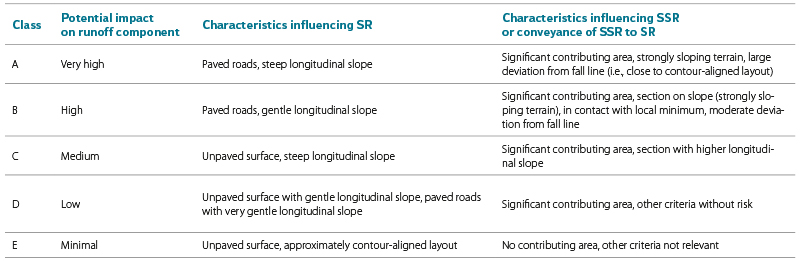
In the first phase of the study, general criteria were formulated for classifying road sections into classes of the basic typology level, separately for surface runoff (SR) and subsurface runoff (SSR). These are summarised in Tab. 1.
Tab. 1. Classes of the basic level of road typology and general combination of key characteristics for classification of individual segments
In the first proposal of the basic typology level, the existence of longitudinal drainage features and the terrain configuration (the position of the road relative to the surrounding landscape) were also considered as key characteristics. Although these characteristics cannot be derived from commonly available data, within the framework of the project, procedures for analysing detailed DTMs obtained using airborne LiDAR techniques were tested, which have become increasingly accessible in recent years. For the analysis of pilot sites selected within the project, a DTM from 2012 with a 1 m resolution, provided by KRNAP, and a DTM with a 50 cm resolution acquired using UAVs were available. In both cases, the products were derived from laser scanning. Approximately 20 cross-sections were analysed at two sites; an example from the site below Špindlerovka, including the locations of the analysed profiles, is shown in Fig. 1.
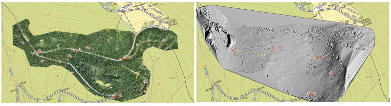
Fig. 1. Orthophoto (left) and detailed DTM (right) derived from UAV data; cross-sections in red are used for testing the identification of roadside drainage features
Analyses of the obtained cross-sections proved to be conditionally useful for obtaining information on the terrain configuration of a road section, or on longitudinal drainage structures. Fig. 2 shows arguably the clearest of the analysed cross-sections at the pilot site below Rennerovky. On the 1 m resolution digital model, road ditches are mostly indistinguishable, whereas at higher resolution they are generally identifiable. However, it is often difficult to identify them amidst the noise caused by remnants of elevation data processing. The terrain configuration of the road was generally satisfactorily visible even on the less detailed 1 m model, whereas the standard 2 m DMR5G model published by the Czech Office for Surveying, Mapping and Cadastre (ČÚZK) was insufficient for this purpose.
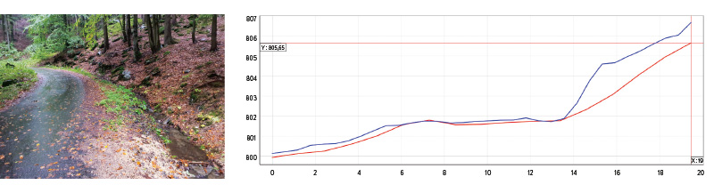
Fig. 2. Cross-section of a road (right) derived from DTMs based on LiDAR scanning with 1 m resolution (red, KRNAP Administration) and 50 cm resolution (blue, CTU) for testing the identification of road terrain alignment and roadside drainage features; photograph of the actual condition from a field survey (left)
In general, a significant problem was encountered with georeferencing aerial data in forested areas and with filtering the captured point clouds. The analysis was further complicated by the positional accuracy of the road network lines, which was already insufficient for this purpose, even in the case of the corrected map dataset from KRNAP, which generally exhibited higher accuracy than the ZABAGED positional data. Automating the process of generating cross-sections and identifying longitudinal drainage features from detailed DTMs proved to be unrealistic, and manual analyses were inefficient compared with a simple field survey. For these reasons, the characteristics of terrain configuration and the presence of longitudinal drainage features were not used for the basic typology level of the road network and were instead assigned to the detailed level.
The following six characteristics were used for the final classification of road sections according to the basic typology level:
Z – Paved/unpaved road (1/0),
M – Connection to a local minimum or crossing with a watercourse
YES/NO (1/0),
S – Average longitudinal slope of the section (%),
D – Deviation of the road from the fall line (0°–90°),
T – Transverse slope of the terrain around the section (%),
W – Contributing sub-catchment area (ha).
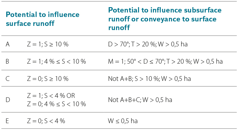
For the application of the basic typology level in the creation of the KRNAP Road Network Map, the classification key from Tab. 2 was used. The threshold values of the criteria and their combinations for classifying road sections were based on a frequency analysis of the occurrence of individual parameter values across KRNAP and may therefore be influenced by the specific characteristics of this area. When applying the typology in other regions, it is advisable to carry out a similar frequency analysis and, if necessary, adjust the threshold values for class boundaries. However, any modification of the combinations of criteria used should be based on a significant objective reason, such as the absence of certain data (for example, information on road surface characteristics may be unavailable). The basic typology level of the road network is designed as an explicit combination of the potential to influence both components of direct runoff, for instance B/C. By incorporating factors identified through detailed field surveys, it can be extended to the detailed level. The application of the typology and the presentation of results are addressed in the Road Network Map section.
Tab. 2. Combinations and values of characteristics for classifying road segments according to the basic level of typology
Detailed typology level
Building on the basic typology level of the road network, which reflects the potential to influence runoff characteristics in the affected area, the detailed level provides a more in-depth analysis of the impact on runoff conditions in individual cases. It supplements the basic typology level with road network characteristics that, given the current state of available data, can only be determined through field surveys.
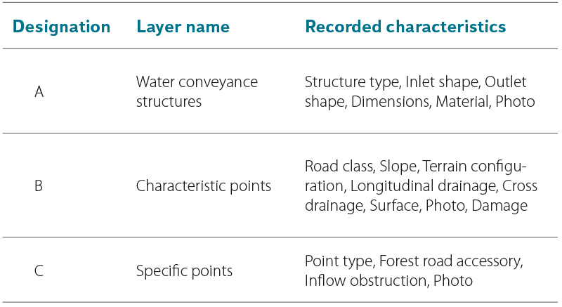
For the detailed survey in KRNAP, five pilot sites were designated. The survey was conducted from July to November 2022 and was slightly supplemented in 2023. Data were collected using the open mobile application QField based on QGIS technology, which allows simultaneous data collection by multiple personnel and subsequent synchronization. After two initial adjustments, the data model for collection was finalised as three separate point layers according to Tab. 3, with photographic annotations. The categories of individual characteristics are not provided here; following the formal completion of the above-mentioned project (no. TITSMZP945), they will be accessible in full in the results report V1 – Road Network Typology.
Tab. 3. Point data layers for field data collection and recorded characteristics
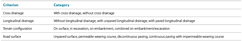
During the development of the basic typology level, or its application to the map, road network sections and nodal points were defined. For the purposes of applying the detailed typology, this division is supplemented by significant specific points of type C (Tab. 3) identified during the field survey (e.g., the end of a longitudinal drainage feature, a change in surface type, etc.). The detailed characteristics recorded at the corresponding type B points are then assigned to the resulting road sections. From the recorded characteristics, four were selected and adopted as the criteria for the detailed typology level according to Tab. 4.
Tab 4. Criteria of the detailed level of road typology
It is evident that the individual criteria are interrelated to varying degrees, and therefore the final assessment of their impact on surface or subsurface runoff must necessarily be based on all criteria simultaneously, which requires a certain level of expertise in runoff processes and hydrology in general. The effects on individual runoff components, as well as guidance for evaluating roads according to these criteria, are provided in the forthcoming project results prepared for publication: V1 – Road Network Typology and V3 – Methodology for Recommendations on the Construction of New and Modification of Existing Roads with Regard to Minimising Surface Runoff (hereinafter referred to as the Methodology). These criteria were applied and graphically represented in result V2 – KRNAP Road Network Map, the derivation of which is described in the following section of this text.
ROAD NETWORK MAP
As the second required output of the project mentioned in the introduction, the KRNAP Road Network Map (hereinafter referred to as the Map) was created, applying the road network typology to assess its influence on the hydrological regime of the area. It was published in the form of three cartographic atlases. The first covers the entire KRNAP area, applying the basic typology level of the road network, while the remaining two expand the basic level with detailed typology criteria for the five pilot sites, allowing a more detailed assessment of the potential to influence subsurface and surface runoff. The Map is intended primarily as one of the key resources for selecting locations suitable for implementing restoration measures and actions to reduce the negative impacts of the road network on the runoff regime within the National Park. In addition, together with the Map’s accompanying documentation and Methodology, it is intended to serve future authors of similar studies in other Czech protected areas as a methodological guide and example for applying the Road Network Typology and assessing road network hydrological impacts. A brief description of the Map creation methodology follows; the full version will be provided in the accompanying documentation, which is scheduled for publication soon together with the Map.
Input data
The primary basis for creating the Map was the linear layer of the road network provided by KRNAP, which was preferred over ZABAGED data due to its higher positional accuracy and more extensive attribute set. Since not all protected areas in Czechia, where the developed methodology was intended to be applied, have access to a similarly detailed dataset, the map creation was also successfully tested on the positional layers from ZABAGED, specifically by combining the following layers:
- Roads, motorways,
- Unregistered roads,
- Streets,
- Paths.
The last-mentioned category, Paths, should ideally be distinguished in the final linear layer according to available detailed attributes. Since 2024, the original classification of Paths as paved/unpaved has been replaced by a new division into Maintained/unmaintained paths. Within the project, the nature and impacts of this change could not be analysed or assessed in detail. The above-mentioned linear layers should ideally be supplemented with data on the classification of the forest road network, which should be available from its administrator.
Digital terrain models DMR4G and DMR5G, as well as the Watercourse layer from the ZABAGED positional data, were also used in creating the map. For the application of the detailed typology level, the point layers of characteristic and specific points from the field survey described in the previous section were employed.
Methodology for creating the map at the basic typology level
Before assigning characteristic values for classifying roads according to the proposed typology, it was first necessary to divide the linear road elements into segments that were homogeneous in terms of alignment and elevation, road surface, and approximate length. This segmentation was carried out in several steps, which are briefly summarised here; the full procedure is provided in the accompanying Map documentation.
The first essential step was to correct the topology of the lines so that they were broken at the road network nodes. Overlaps and incomplete lines are undesirable. Pseudo nodes – i.e., the junction of two linear elements – are allowed only at locations where an attribute key to the classification of the segment according to the typology changes (in this case only a change in road surface). In the base layer provided by KRNAP, these rules were broken in several hundred instances and had to be semi-automatically removed. When using ZABAGED positional data, the topology of the resulting network must be cleaned according to these rules after merging the specified linear layers.
Division at locations of alignment breaks
Sharp changes in alignment and curves are frequent locations for changes in several road characteristics – longitudinal slope, configuration relative to the terrain, the presence of longitudinal drainage features, and others. Since standard GIS tools are unable to identify these points on linear features, custom analytical scripts were developed in the R project environment for this purpose. In the first step, sharp alignment breaks were identified where adjacent vertices formed an angle of less than 100°; in Fig. 3, such a break is marked with a red triangle. In the second step, sharp curves – represented in the linear data by a series of very short segments – were identified. For this purpose, each line was approximated using points at a constant spacing of 15 m, and an empirical threshold of 120° was applied to adjacent points; in Fig. 3, the sharp curves are indicated by circles, with colours reflecting their significance. For the final division of the lines, points that were too close to each other or located near road network nodes were filtered out, as these could otherwise have caused undesirable fragmentation of the road network.
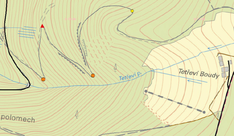
Fig. 3. Sharp break point (red triangle) and three prominent curves (orange and yellow circles) as split points of the access road to Tetřeví boudy
Crossing watercourses
It is advisable to split road lines at the point where they cross a watercourse, as such locations often (though not always) involve a change in elevation. The connection of a segment to a watercourse, or to a local elevation minimum, is also one of the characteristics used for the classification of segments according to the proposed typology. However, junction nodes of the road network (intersections) are often located close to crossings, and in such places it is undesirable to split segments, as this would lead to excessive fragmentation. In the wider area of KRNAP, more than 2,700 intersections with surface sections of watercourses were identified but, after filtering out unsuitable points, fewer than half of them were used.
Identification of elevation extremes
To ensure correct calculation of slope parameters, it is necessary to divide road lines at local elevation extremes. Since standard GIS tools do not allow for the identification of these locations, custom analytical procedures were again developed and tested in the R project environment.
For the identification of optimal tool settings, points were generated along each road segment in four spacing variants (2, 5, 10, and 20 m) and assigned elevation values from DMR5G. At each point, its elevation was assessed in the context of the two neighbouring points, and local maxima and minima were indicated according to the required elevation difference threshold (five variants ranging from 10 to 150 cm). The extremes were then classified into six levels of significance based on their height or depth, as well as their width and continuity of slope (presence of inflection) in the evaluated surroundings.
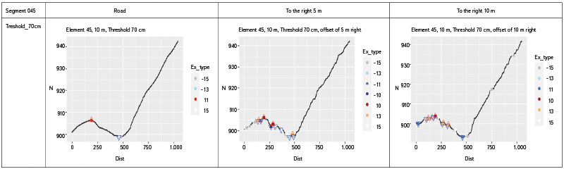
To verify potential errors in the alignment of roads, the same analysis was repeated for parallel lines on both sides of the roads at offsets of 5 and 10 m. Automatically generated longitudinal profile graphs were systematically subjected to visual inspection in groups, one of which is shown in Fig. 4. This approach confirmed sufficient accuracy of the alignment of road lines compared with their parallel offsets. An offset of 10 m and an elevation threshold of 70 cm proved optimal for constructing longitudinal profiles. Finally, points located close to road network nodes were removed, and the occurrence of nearby opposite extremes was corrected.
 Fig. 4. Example of longitudinal profiles of the road section axis (left) and two equidistant lines at an offset of 5 and 10 m (center and right), along with identified local elevation extremes. The profiles were derived from points with 10 m spacing, with a vertical threshold of 70 cm used to indicate significant extremes
Segmenting by length and determining segment characteristics
After accounting for directional changes, watercourse crossings, and elevation extremes, the resulting road segments were divided into 200 m lengths. This completed the homogenization of road network segments, after which the segment characteristics were calculated for the application of the typology. The average slope of each segment was derived from DMR5G along the road lines. From a smoothed DMR4G raster, a slope raster was generated, and within a 20 m buffer zone around the segment axes, the average slopes of the surrounding terrain were evaluated. A more detailed DMR5G is not suitable for this purpose, as it also captures the elevation characteristics of the road itself, such as cuttings or roadside ditches. For the same reason, DMR4G was also used to derive the contributing areas (micro-catchments) of road segments. A simplifying assumption of complete interruption of runoff by the road was adopted, since the actual capacity of a road to retain runoff cannot be determined without a detailed field survey. To derive the contributing areas, a complex procedure was developed, which involved removing the road axes and surface watercourses from the DMR and expanding the raster representation of the roads. A detailed description of this procedure is beyond the scope of this article.
Application of the basic typology level and map production
Using database processing tools, values of characteristics determining the significance of each road segment for influencing surface and subsurface runoff were assigned to vector road segments according to the developed Road Network Typology. After classifying each segment into combined categories (SR and SSR), the final Map for the entire KRNAP area was produced. Given the extent and level of detail of the information displayed, the Map was organised as an atlas of map sheets at a scale of 1 : 25,000. The potential influence on SR is indicated by variable line thickness, while the potential influence on SSR is shown using a simple accompanying label. An example map sheet is shown in Fig. 5.
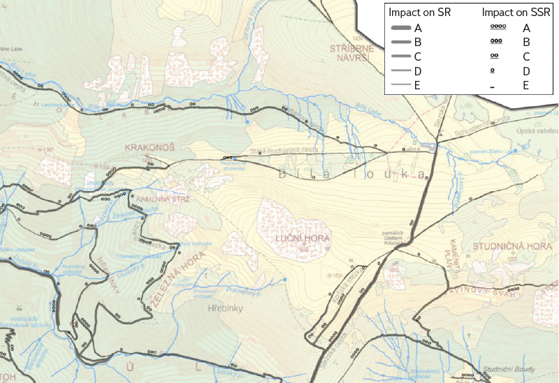
Fig. 5. Excerpt of the road network map with the applied basic level of typology showing the potential impact on runoff components
Methodology for producing the detailed typology level map
The detailed typology level map of the road network expands the basic level map by incorporating insights from field surveys, specifically the characteristics listed in Tab. 4. These and other road characteristics were collected and compiled into three point layers, including photographic annotations, which can be appropriately displayed using standard GIS tools, although displaying multiple photographic attachments per point in ArcGIS Desktop posed a considerable challenge. The collected points naturally did not match in density the derived segmentation of the road network created during the production of the basic level map. Similarly, the points were generally not located directly on the line of the road segment, either due to inaccurate GPS positioning in forested mountain areas, errors in point placement, or even the absence of the road line in the map base. Therefore, a series of preparatory steps had to be undertaken before applying the detailed typology.
Harmonization and completion of survey data
The quality and completeness of the attributes in the field survey points is crucial for successful application of the detailed typology to road segments. Due to differences in mapping strategies among individual field workers, for the “cross drainage” characteristic, just over 1,000 of nearly 2,600 points contained either no information or only the category “other”. Missing characteristics had to be completed using the collected photo documentation or, where appropriate, validated against neighbouring points. In addition to filling in missing attributes, the consistency of characteristics assigned by individual field workers was spot-checked and corrected to remove subjective bias, for example in the case of the road’s configuration relative to the surrounding landscape.
Assignment of points to road segments
The positions of points collected during the field survey using GPS were subsequently corrected and linked to the corresponding road segments. GPS positional deviations of the points relative to the road centreline in the map dataset ranged from a few metres up to several tens of metres. Although in many cases there was evidence of errors in the map base, in order to maintain consistency with the original data provided by the KRNAP Administration, the road lines were not corrected; instead, the recorded points were automatically moved to the nearest position on these lines. Following testing of various values, a distance of 20 m was chosen as the maximum threshold for moving a point. Points beyond this threshold had to be assigned manually or completely excluded to avoid, for example, assigning a point that characterises a road not recorded in the map base. A thorough visual inspection and correction of incorrectly assigned points was necessary, particularly in the areas of junctions.
Additional segmentation and transfer of characteristics
Some road network characteristics included in the detailed typology can change abruptly, such as surface type or longitudinal drainage, and it is necessary to split the assessed road segment at these points of change. A subset of specific points from the field survey was used for this segmentation. The recorded vertical alignment break was checked with respect to the proximity of a network node or a local extreme identified from the DTM. Changes in surface type or longitudinal drainage were verified using the photo documentation and surrounding characteristic points. In total, around 130 road segments underwent additional segmentation.
Based on spatial coincidence, the road segments were then to be assigned attributes from the layer of characteristic points. Prior to this, however, it was necessary to check segments with multiple characteristic points assigned. The number itself is not fundamentally an issue if the points contain identical characteristics. Thanks to its easy identification in the field, the cleanest attribute was the type of surface. On the other hand, the most problematic characteristic was terrain configuration (over 100 ambiguous assignments), since these changes in the field are always rather gradual and no specific-point category had been established for them. After checking the consistency of these data using photo documentation, the road network was finally additionally split approximately halfway between two points with differing characteristics. Subsequently, road segments were assigned the attributes from the characteristic points.
The final step involved addressing segments without a corresponding characteristic point. Their number depends on the density of points collected during the field survey. A typical example of the situation after projecting points onto road segments is shown in Fig. 6. For empty segments, attributes from neighbouring segments were transferred iteratively (forward/backward), provided that no specific point indicated a change in the given attribute between them.
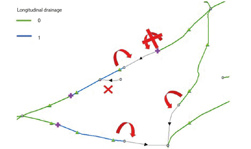
Fig. 6. Diagram of transferring the roadside drainage attribute to adjacent segments, taking into account specific points (purple crosses) marking changes in the roadside drainage system; green triangles indicate characteristic points
Application of the detailed typology level and map creation
The map with the detailed typology level similarly builds on the basic-level map and complements it with an appropriate representation of the detailed typology criteria. The detailed map was designed as a set of two cartographic atlases: one for the subsurface component of runoff and the other for the surface component. The graphic design consists of a clear combination of line thickness (representing the potential influence on the runoff component from the basic typology level), a colour code expressing terrain configuration as a key factor affecting the hydrological regime, and accompanying symbols to depict the remaining characteristics of the detailed typology. The result is shown in Fig. 7.
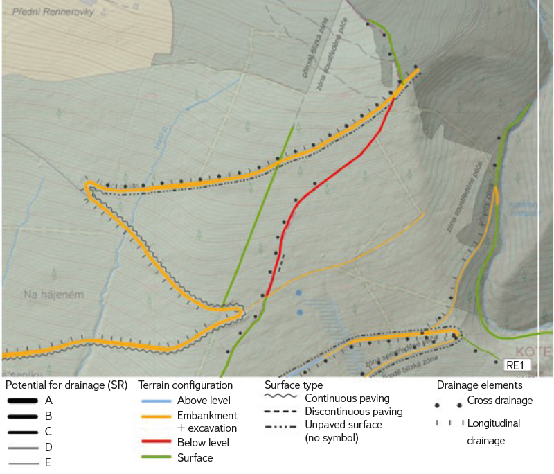
Fig. 7. Example of applying detailed typology to the road network in the Rennerovky pilot area
CONCLUSION
Linear elements in the landscape, and particularly the road network, have a significant potential to influence water runoff from an area. Under specific conditions, this influence can be positive; however, it generally tends to accelerate water runoff, which is usually considered undesirable. The project, the selected results of which are presented in this text, aimed primarily to provide the data and tools needed to identify problematic sections of the road network and to minimise their undesirable effects, which lead to accelerated water runoff from areas under special nature protection. The presented typology and methodology for its application to map outputs will assist in identifying such problematic locations, at two possible levels of detail – the basic level, relying solely on available map data, and the detailed level, utilising results of field surveys focused on a set of clearly defined road characteristics. The derived maps can serve as a basis for selecting and prioritising road sections in protected areas that are suitable for the implementation of mitigation measures, or even for the complete removal and restoration of a road. The principles of such measures are addressed in another output of the aforementioned project – the Methodology for Recommendations on the Construction of New and Modification of Existing Roads with Regard to Minimising Surface Runoff – which is scheduled for publication by the end of 2025. Together, these outputs provide managers of natural areas – whether under strict or general protection – with tools to better reconcile human interests in accessing the landscape with the protection of its natural runoff processes.
Acknowledgements
This article was written with the support of Research Task VÚ1: Research and Assessment of the Hydrological Regime under Current and Projected Conditions, within the Long-Term Development Concept of the TGM WRI for 2025.
The Czech version of this article was peer-reviewed, the English version was translated from the Czech original by Environmental Translation Ltd.
