ABSTRACT
This article focuses on evaluating the concentrations of humic substances (HS) in peatland waters in the Ore Mountains region, specifically in the area near the village of Hora Svatého Šebestiána in the Prameniště Chomutovky nature reserve. The aim was to assess the impact of restoration measures on the occurrence of HS in surface and subsurface waters in a post-peat-extraction environment. Monitoring was carried out from 2022 to 2024 on two experimental sites – one restored (site A) and one predominantly non-restored (site B) – and involved extensive monthly sampling, installation of flow weirs, shallow observation wells, and meteorological stations.
The results show that restoration affects the dynamics of HS occurrence. In surface and groundwater from the restored site, higher minimum HS concentrations and greater annual variability were observed, whereas the non-restored site showed lower minimum but higher maximum concentrations under dry hydrological conditions – when surface runoff and the associated transport of substances are minimal. The ratio of humic to fulvic acids (HA/FA), important in terms of water treatment and chemical behaviour, was less favourable in the restored site, indicating a higher proportion of poorly degradable fulvic acids.
During significant rainfall-runoff events, HS concentrations decreased, but the overall volume of mobilized organic matter increased. The study also demonstrated a notable self-purifying effect of the recipient stream, which reduced occasional higher HS concentrations from restored sites, and a positive effect of the retention reservoir on water chemistry, with reduced peak HS concentrations and an increased HA/FA ratio at the outflow.
The findings provide valuable insights for planning water management measures in peatland areas and help to clarify the dynamics of organic substances within peat bogs and their drainage systems. The results may contribute to improving the quality of water sources when planning restoration efforts in peatlands affected by peat extraction.
INTRODUCTION
The hydrological significance of mountain peatlands has long been debated, particularly regarding their contribution to the hydrological regime. This includes their role in retaining water during periods of high precipitation, supporting base flow in streams during dry periods, and influencing water chemistry through peatland restoration. Restoration typically involves blocking drainage channels, which were originally created to drain the peatland for peat extraction. Expert opinions on the influence of peatlands on the hydrological regime of catchments are contradictory; for example, study [1] highlights the benefits of peatlands and their restoration in stabilising the hydrological regime in the Šumava region. In contrast, study [2] finds no significant contribution of peatlands to water retention or the maintenance of water supplies during dry periods in the same region. To monitor these hydrological and, in particular, hydrochemical processes, and to clarify some disputed hypotheses, a comprehensive monitoring programme was initiated in the Ore Mountains peatlands near the village of Hora Svatého Šebestiána. The monitoring covers both quantitative and qualitative aspects of hydrology. This paper focuses on the results describing the content of humic substances (HS) in surface and subsurface waters in both restored and non-restored parts of the peatland.
Description of the Study Area
The study area comprises two experimental sites, A and B (Fig. 1), located in the central part of the Ore Mountains, southwest of the village of Hora Svatého Šebestiána, at an altitude of 850–895 m a.s.l. Both sites are peatlands with a history of completed peat extraction, which left drainage channels that artificially lowered the groundwater level. These channels are currently being gradually restored through the construction of weirs, aimed at returning the hydrological regime to a state closer to natural conditions. Site A covers approximately 0.4 km² and is characterised mainly by sparse dwarf pine and spruce stands in the peripheral areas, which transition into grassland. Site B occupies roughly 1 km² and exhibits a more diverse structure, spanning two hydrological catchments: the Chomutovka River to the north and the Prunéřovský Stream to the south. At the edge of site B lies Novoveský Pond, with an area of 3.86 ha, which historically served as a water reservoir for the Chomutovka River. At present, the area is a valuable habitat providing refuge for protected animal species. A particular feature of the site is the Chomutovka diversion channel, which supplements the natural flow of the Chomutovka River with water from the Černá River catchment. The diversion passes through both study sites and alters the natural runoff patterns, although its current function is limited due to its reconnection to the Černá River.
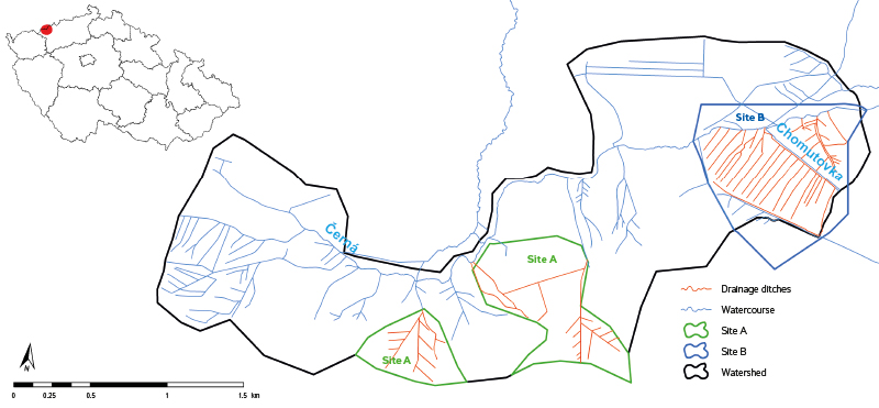
Fig. 1. Schematic diagram of monitoring sites A and B (site A on the left corresponds to the watershed for profile V1-CH1, see Fig. 2); in many cases, the Chomutovka watershed does not respect the slope conditions of the catchment area due to drainage channels, therefore, the watershed is based to a certain extent on field surveys and subsequent expert estimates
The geological substrate consists of rocks of the Ore Mountains crystalline complex, specifically paragneisses, orthogneisses, and amphibolites, with occurrences of skarns. Overlying these are Quaternary sediments, predominantly clayey and peat-rich. From a hydrogeological perspective, the area is a fractured-rock aquifer with very low permeability peat layers, which act as a natural barrier.
From a pedological perspective, the area is predominantly covered by modal podzols, with gley soils and histosols occurring in permanently waterlogged locations. According to Quitt, the climate falls within the mountainous CH6 region, characterised by a long, wet winter and a short, cool summer.
The site is located within the Ore Mountains protected area of natural water accumulation (CHOPAV) and lies close to the protection zones of groundwater sources supplying the village of Hora Svatého Šebestiána. Historically, the area has been affected by mining activities, particularly remnants of ore extraction from the 14th–17th centuries. These features may locally influence the hydrological regime.
Humic substances in peatlands
HS, particularly humic and fulvic acids, are the main components of dissolved organic matter (DOM), which is released in significant amounts from peatlands into surface and groundwater. These substances have a complex macromolecular structure rich in aromatic and functional oxygen groups [3], giving them a high affinity for forming complexes with metals (e.g., Fe, Al, Cu) and the ability to influence the transport of toxic substances in the environment. From the perspective of drinking water treatment, HS pose a significant problem: during chlorination, they can react with disinfectants (particularly chlorine compounds) to form disinfection by-products, many of which (e.g., trihalomethanes) are carcinogenic [4, 5]. In addition, they increase the need for coagulants and adsorbents during water treatment [6], reduce filtration efficiency, and can negatively affect the taste and smell of water [7]. In areas with peatlands, particularly during periods of high flow, the concentration of dissolved organic carbon (DOC) in raw water sources fluctuates, complicating the technological stability of treatment plants and increasing operational costs [8].
In the Ore Mountains, the occurrence and behaviour of HS in peatlands have been investigated in several significant studies, with attention given both to natural factors (hydrological regime, botanical composition) and to the influence of anthropogenic acidification and land-use changes. Pokorný et al. analysed the long-term development of peatlands using palaeoecological methods, including the impact of climatic extremes on the accumulation and transformation of organic matter [9]. Charamba et al. mapped the chemical composition of water in peatlands across central Europe, including sites in the Ore Mountains, and demonstrated that the local raised bogs have a high proportion of aromatic DOM fractions with low biodegradability [10]. Studies from the Boží Dar and Cínovec peatlands further show that following drought episodes and subsequent rewetting, there is a pronounced pulsed release of DOC into receiving waters, confirming the sensitivity of these systems to climatic extremes [11]. Some studies have also demonstrated a relationship between fulvic acid concentration and increased iron mobility, which has a direct impact on eutrophication and the water chemistry of adjacent streams [12]. These findings are crucial not only for the ecological protection of peatland ecosystems but also for the optimisation of water management measures in catchments with a significant proportion of wetland areas.
METHODOLOGY
Monitoring
Monitoring of the peatlands in sites A and B was designed as a comprehensive system to observe hydrological and climatic conditions in an environment altered by historical peat extraction. The overall aim of the monitoring is to evaluate the effectiveness of restoration measures, which involve the construction of weirs to retain water and raise groundwater levels, and to assess their impact on changes in the chemistry of surface and groundwater, with a focus on the occurrence of organic substances. Restoration in the form of blocking drainage channels has already been completed across almost the entire area of site A. In contrast, site B remains largely in a pre-restoration state, and manual sampling is focused in these areas. As part of the monitoring, wells, flow weirs, meteorological stations, and automatic samplers were installed at both sites, allowing observation of the status and chemistry of surface and groundwater, precipitation, temperature, air humidity, and snow water equivalent. For the evaluation of HS occurrence, the part of the monitoring network focused on water chemistry was used. The other measurement points served, among other purposes, to monitor background processes associated with the dynamics of organic substances in surface and groundwater.
For the comprehensive monitoring of site A (Fig. 2), the existing well network of series P, PA, and PV was used, in which groundwater level, temperature, and conductivity are measured manually twice a year. In addition, wells of series D1 to D5 were installed, equipped with pressure sensors for continuous measurement of groundwater level and temperature. Selected wells, such as D2 and D5, were installed as paired wells – one penetrating only the upper peat layer (acrotelm), while the other reached the lower peat layer (catotelm). Wells D1 and D3 also serve for monthly water sampling for laboratory chemical analyses.

Fig. 2. Monitoring facilities in site A
Site A contains four flow weirs: V1-CH5, located at the eastern edge with a triangular profile (so-called Thomson weir); V2, in the west, equipped with a circular weir and built directly into the dam structure; V3, situated in the southeastern part, which drains water from the forested area; and V1-CH1, located approximately 400 m west of profile V2, which serves exclusively as a reference point for manual surface water sampling without continuous measurement. All weirs are equipped with sensors for measuring water level, temperature, conductivity, and pH, and weirs V3 and V1-CH5 are used for surface water sampling.
Hydrological monitoring in site B (Fig. 3) was considerably expanded. Fifty-five shallow wells of series B, with a maximum depth of 3 m, were installed in a regular grid covering both restored and non-restored parts of the peatland. In addition, wells of series D8 to D18 were installed, with D11, D14, and D16 also set up as paired wells to compare water levels between the acrotelm and catotelm. Wells D8, D14, and D16 are also used for water sampling and chemical analysis. This observation network provides detailed information on the hydrological conditions across the peatland.
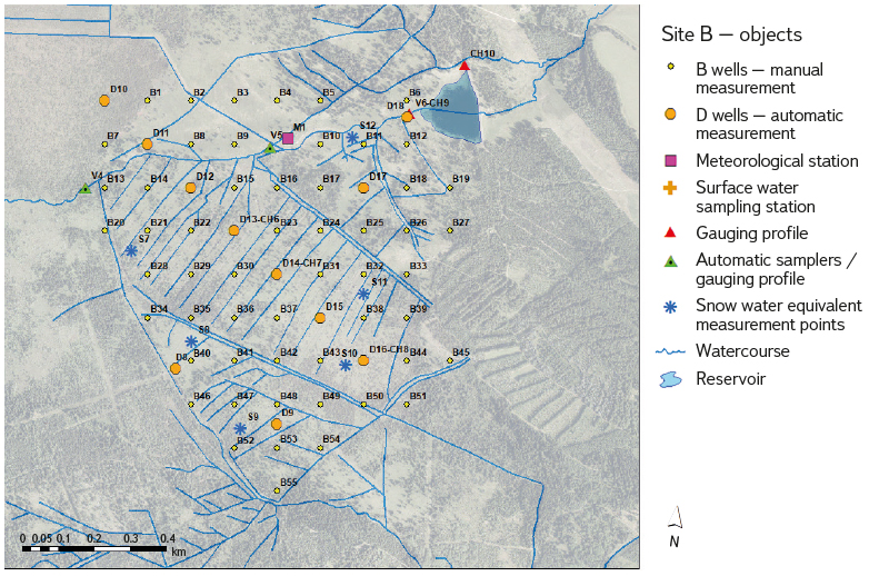
Fig. 3. Monitoring facilities in site B
Surface waters in site B are monitored through several flow weirs. Weir V4, in the western part, is equipped with a rectangular notch and it monitors inflow from the area below Jelení hora. V5 is located on the Chomutovka diversion channel and is fitted with an ultrasonic sensor. Weir V6, situated on the Chomutovka River, is located at the last weir before the inflow into Novoveský Pond and is used for sampling. For sampling the Chomutovka River below the pond, profile CH10 is used downstream of the safety weir, where manual hydrometric measurements are conducted.
Meteorological stations are installed at both sites. In site A, a basic station records air temperature, humidity, and precipitation. In site B, a comprehensive climatological station additionally measures wind speed and direction, solar radiation, soil heat flux, and soil moisture. For year-round precipitation measurements, a heated rain gauge was installed in the village of Hora Svatého Šebestiána, which also serves to trigger automatic samplers during rainfall events.
Groundwater
Groundwater samples are collected monthly from selected wells of series D. These include wells D1-CH2 and D3-CH3 in site A, and wells D8-CH6, D14-CH7, and D16-CH8 in site B. Sampling was always scheduled at the end of each month, taking care to ensure stable and consistent meteorological and hydrological conditions. This means that no significant hydrometeorological extremes occurred during or immediately before sampling that could have temporarily affected groundwater quality. Samples are transported to the VZlab laboratory, where the following parameters are determined:
Chemical oxygen demand (COD-Mn), N–NO₃–, N–NO₂–, N–NH₄+, total nitrogen (Nt), SO42-, total phosphorus (Pt), Fe, Al (dissolved and particulate), DOC, A₂₅₄, (A₂₅₄/DOC)*100, total hardness (TH), HS, humic acids, and fulvic acids.
Surface water
Surface water samples are collected monthly together with groundwater sampling. The same rule applies: sampling is always conducted at the end of the month under as stable hydrometeorological conditions as possible. Sampling is carried out at weirs V1-CH5 (restored catchment), V3-CH4, and V7-CH1 (forest non-restored catchment) in site A, and in site B at weir V6-CH9 (Fig. 4) and at sampling site CH10 downstream of the safety flow weir of Novoveský Pond (non-restored catchment, Fig. 6). The current flow in the watercourse is recorded during sampling. Sampling sites V7-CH1 and CH10 do not have continuous water level measurements, therefore flows at the time of sampling are measured and calculated on site. At profile V7-CH1, a flow weir was installed for this purpose. At profile CH10, hydrometric measurements are conducted during sampling. Samples are then transported to the VZlab laboratory, where the following parameters are determined:
COD-Mn, N–NO₃–, N–NO₂–, N–NH₄+, Nt, SO42-, Pt, Fe, Al (dissolved and particulate), DOC, A₂₅₄, (A₂₅₄/DOC)*100, TH, HS, humic acids, and fulvic acids.
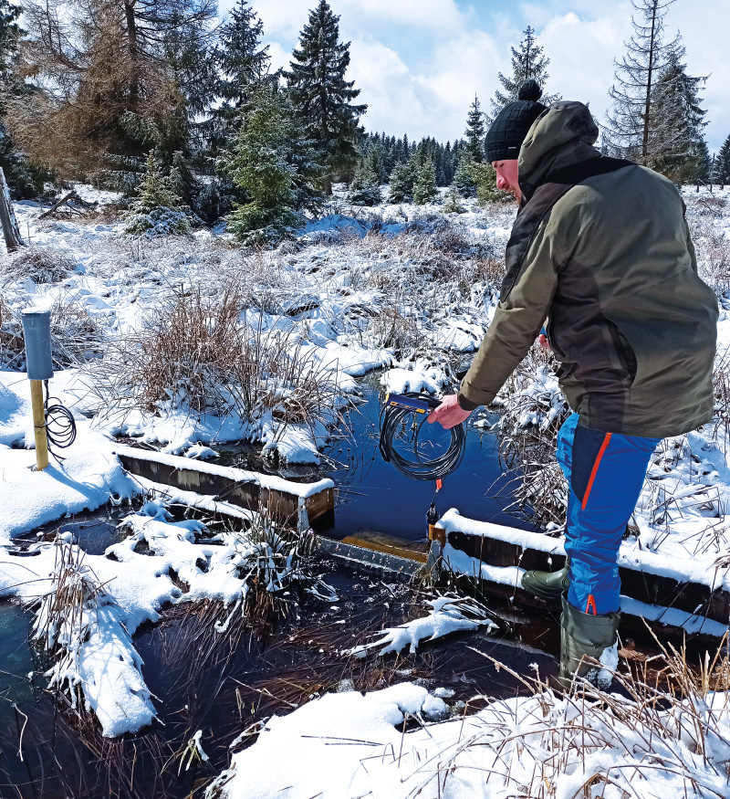
Fig. 4. Measurement of chemical parameters of surface water at profile V6-CH9
 Fig. 5. Results of chemical analyses of selected parameters

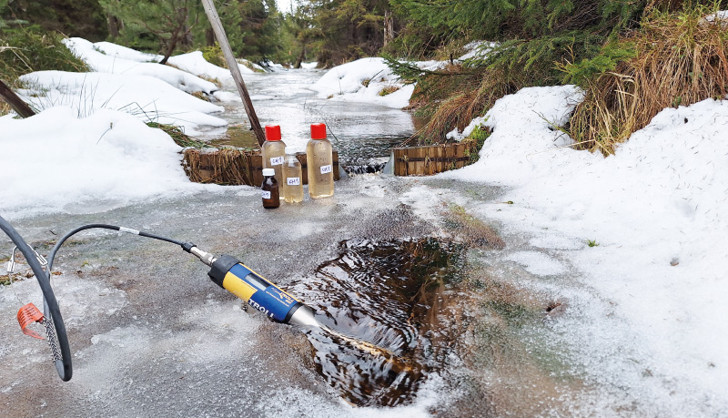
Fig. 6. Sampling and measurement of chemical parameters of surface waters at profile V7-CH1
The number of samples collected depends on hydrological conditions. During dry periods or generally in the summer months, groundwater levels may fall below the depth of the wells, and watercourses may dry out, making sampling impossible. For each groundwater and surface water sample, supplementary measurements of conductivity and water pH are performed using an Aquatroll 500 multiparameter probe.
Samples are also collected using ISCO 6712 automatic samplers at profiles V4 and V5 (Fig. 10), designed to capture the chemical response of the watercourse to rainfall events. The parameters determined are the same as for manual sampling. Sampling is synchronous: when a hydrological event is anticipated, the sampler at V5 is activated via SMS. The V5 sampler is locally linked to the sampler at V4, which is outside stable GSM coverage, so V4 is triggered at the same time. A total of 24 samples are collected at two-hour intervals, of which 10 are selected for analysis, ideally covering the watercourse’s response to precipitation. The reach between the two samplers is approximately 600 m long, receiving water from a single already restored area in site B, and the aim is to capture any chemical changes along this section.
RESULTS
The following results are based on two years of monthly sampling. Of all the chemical parameters observed, this article focuses on HS and related indicators of the presence of organic matter in water (the ratio of humic to fulvic acids – HA/FA, dissolved organic carbon – DOC, and absorbance at 254 nm – A₂₅₄). Fig. 5 shows the results for groundwater and surface water sampling sites CH1–CH10. Sites (wells) CH2 and CH6 were excluded from the evaluation because of the very low number of samples obtained, due to the absence of water in the wells. The results show seasonality in the HS content of surface waters, with concentrations increasing during summer low-flow conditions. In contrast, groundwater does not exhibit such pronounced fluctuations and no clear seasonality is apparent. Only well CH7 recorded three higher values, but these were measured at very low groundwater levels, which may have resulted in the sampling of sediment from the well bottom. In general, groundwater shows higher HS concentrations throughout the year, except in summer months, when surface water displays elevated concentrations not only of organic substances but, according to the analyses, also of metals (Fe, Al) and total nitrogen [13]. Other indicators linked to the presence of organic matter in water (DOC and A₂₅₄) exhibit similar patterns. Comparing concentration dynamics in surface water from restored (CH5) and non-restored sites (CH9 and CH10), profile CH5 shows higher minimum HS concentrations and overall greater variability during the year, while summer maxima are lower. By contrast, profile CH9 maintains consistently lower winter minima, but in summer reaches up to twice the HS concentrations. This results in fairly balanced average values over the entire monitoring period (Tab. 1): CH5 – 41.5 mg/l, CH9 – 40.7 mg/l. However, discharge during sampling has a significant influence on the total export of organic matter. The highest discharges usually occur in winter during snowmelt. While concentrations at profile CH9 during this period remain below 25 mg/l, those at CH5 are up to twice as high. Conversely, higher concentrations at CH9 are recorded under very low discharges of around 1 l/s or less. This results in a greater overall export of organic substances from the restored site. However, in comparison with the non-restored site, the higher concentrations in the restored site are reached even at higher discharges and during wetter periods, when the load of HS in the stream is quickly diluted by additional inflows with lower HS content. According to analyses carried out as part of a concurrently prepared bachelor thesis [14], concentrations of HS decreased by more than 80% along an approximately 5 km section of the Chomutovka Stream. To reduce the influence of occasionally occurring extreme values, Tab. 2 presents the median concentrations for each site: CH5 – 32 mg/l and CH9 – 15 mg/l.
Tab. 1. Average values of the monitored chemical parameters; the worst results in terms of water quality are highlighted in bold
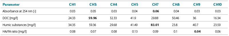
Tab. 2. Median values of the monitored chemical parameters; the worst results in terms of water quality are highlighted in bold
For groundwater, higher HS concentrations are recorded for most of the year at well CH3 in the restored site. The overall average is highest at CH7, but this is due to the three previously mentioned outlying values. However, considering the median concentrations, well CH7 has similar HS levels to CH8, which is located in a drained but relatively intact part of the peatland and exhibits the lowest HS concentrations. The highest median concentration is observed at well CH3 in the restored site.
Water quality is affected not only by HS concentrations but also by the ratio of humic to fulvic acids (HA/FA). A higher proportion of fulvic acids negatively impacts drinking water treatment because they are more soluble and more difficult to remove. The HA/FA values are close to zero and only occasionally exceed 1. No seasonality is apparent, and each series contains one or two outliers that are unrelated to water level or season. Therefore, conclusions are based on the median values shown in Tab. 2. The lowest HA/FA ratio, and thus the highest proportion of more persistent fulvic acids, occurs in the restored part of site A, specifically at sampling sites CH5 and CH3. By contrast, the highest values were recorded at the profile draining the forested area (CH1), at well CH8 in the non-restored site, and at profile CH10 at the reservoir outflow.
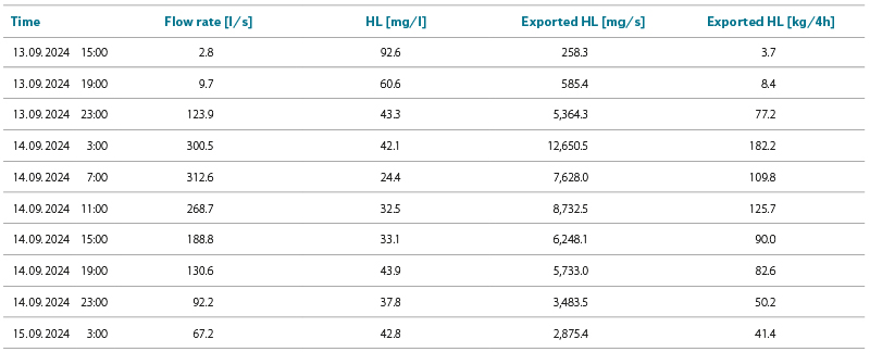
During the monitoring period, a significant rainfall-runoff event was recorded using automatic samplers from 13 to 15 September 2024. The samplers were synchronously activated before the onset of the runoff response and collected samples at 2-hour intervals over a period of 40 hours. To capture both the rising and falling stages of the water level, 10 samples were selected for analysis at 4-hour intervals. The results shown in Figs. 7 and 8 indicate a similar pattern of change in HS and DOC concentrations. At the start of the event, concentrations are high, and as discharge increases, they decrease during the first 12 hours to values that remain relatively stable thereafter, even though discharge continues to rise significantly. This pattern is consistent for both sampling profiles, even though channels from the restored part of site B discharge into the stream between them. HS concentrations also decrease by almost half between the sampling sites. The HA/FA ratio between the samplers increases, particularly during the peak of the event. No increase in HS concentrations caused by inflow from the restored site was observed between profiles V4 and V5. When HS concentrations are converted to the total exported mass, the results are given in Tab. 3. At the start of the event, under the lowest discharge and highest concentration, HS export was 258.3 mg/s. By contrast, immediately before the peak, HS concentrations are still decreasing, and export reaches 12,650.1 mg/s. At the peak, it declines to 7,628 mg/s. HS concentrations then gradually increase; however, the decreasing discharge causes a slow decline in exported HS mass. Over the 40-hour monitoring period, approximately 771 kg of HS were exported through the profile. This topic is also addressed in the bachelor’s thesis [15].
Fig. 7. Results of automatic sampling during the significant rainfall-runoff event from 13–15 September 2024 at profile V4
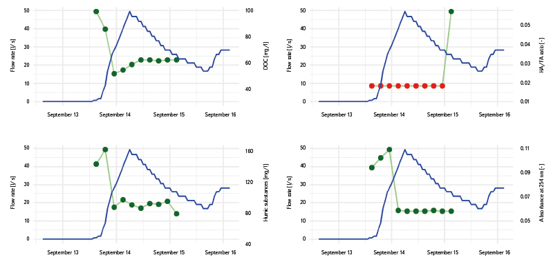
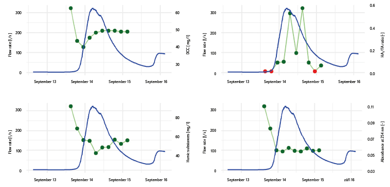
Fig. 8. Results of automatic sampling during the significant rainfall-runoff event from 13–15 September 2024 at profile V5
Tab. 3. Calculated amount of exported HS during the significant rainfall-runoff event from 13–15 September 2024 at profile V5
Given the increase in discharge between the two profiles, it can be assumed that the stream also receives a substantial contribution from the non-restored site. In this case, a precise delineation of the catchment and source areas for each sampler profile would be beneficial. However, this is essentially impossible because the stream itself is an artificially constructed channel crossing natural watercourses and is connected to a network of drainage channels, which overflow into other drainage paths during higher flows.
Effect of the reservoir on stream water chemistry
The positive effect of Novoveský Pond on stream water chemistry is already evident from the results shown in Tab. 1, Tab. 2, and Fig. 5. Fig. 9 illustrates the percentage change in concentrations of all monitored substances between profile CH9 above the reservoir and profile CH10 below it. Decreases were observed for DOC, aluminium, absorbance, chemical oxygen demand determined by permanganate (CODmn), conductivity, total phosphorus, total nitrogen, and sulphates. An increase in pH and the ratio of humic to fulvic acids (HA/FA), reflecting a higher proportion of humic acids, can also be considered beneficial. Acid neutralising capacity (ANC₄.₅) was also increased, most likely as a result of the higher pH.
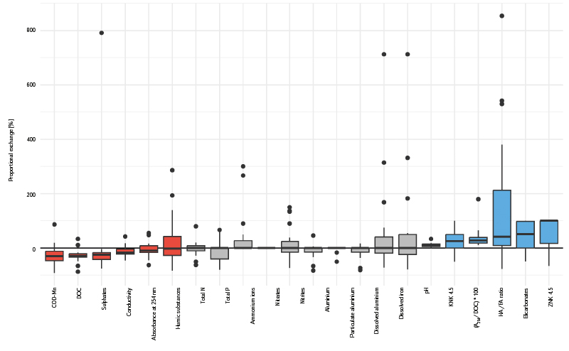
Fig. 9. Box plots of percentage change in substance concentrations between profiles CH9 upstream of the reservoir and CH10 downstream of the reservoir; the main part is the “box” between the first and third quartiles, inside which is a line indicating the median; the box has “whiskers” that show the range of data outside the quartiles (typically up to 1.5 times the interquartile range); outliers are shown as separate points outside the whiskers
A slight increase in undesirable parameters was observed for dissolved iron concentrations. Although DOC values are low, the higher pH creates more favourable conditions for the release of metals into the water column. The increase in pH is also associated with higher bicarbonate concentrations. Values of the indicator (A₂₅₄/DOC) * 100 are elevated, reflecting both the higher proportion of humic acids and the decomposition of organic matter accumulated on the reservoir bottom.
Probable mechanisms contributing positively to HS content and the HA/FA ratio include exposure to sunlight, which induces photodegradation and reduces the molecular weight of humic acids. Microbial activity and the presence of iron and aluminium also play a role, facilitating complexation and the coagulation of HS into sediments [16, 17]. The transformative effect of the reservoir is also significant, as it dilutes higher concentrations entering from the inflow to lower levels. Consequently, in the stream below the reservoir, minimum concentrations of chemical parameters are higher compared with the inflow, while maximum values, typical of the water entering the reservoir, are substantially reduced.
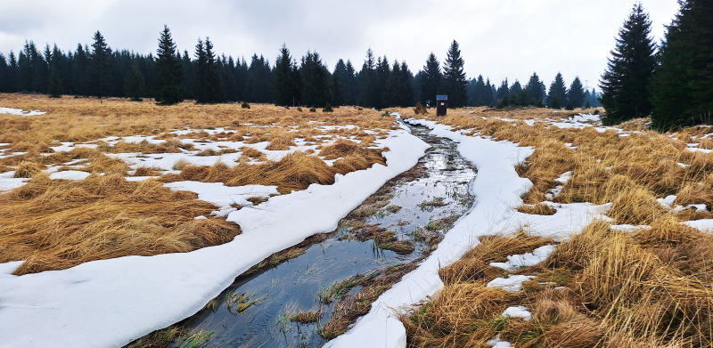
Fig. 10. Water channel with an automatic sampler at profile V5
DISCUSSION
The effect of peatland restoration on HS content in groundwater and surface water cannot be generalised, as each hydrological system within a peatland may respond differently. For example, study [18] reports a long-term increase in organic matter concentrations in water. In contrast, other studies document a sudden increase in concentrations immediately following restoration, followed by a decline, although values remain higher than the original levels [19, 20]. Some studies, on the other hand, report no changes in organic matter concentrations [21, 22]. There are even studies documenting a decrease in organic matter concentrations following the damming of drainage channels and an increase in groundwater level [23–25]. For example, study [23] attributes the decline in HS concentration to the elevated groundwater level, which dilutes concentrations throughout the peatland. However, higher degrees of wetness are generally cited as a reason for increased export of organic matter.
Study [26] in the Kamenička and Fláje catchments also examined the relationship between organic matter content, precipitation, and discharge, reporting the highest export of substances 1–2 days after rainfall. In our study area, where we focused primarily on the peak flow period, concentrations of the monitored substances increased immediately at the onset of the rising water level or were followed directly by a decrease due to dilution by rainwater. However, as shown by calculations of total exported mass, a much larger quantity of organic matter is transported during periods of lower concentration combined with higher discharge than during low discharge and high concentrations. The study also describes a positive effect of the reservoir on organic matter concentrations. However, this is probably primarily due to the temporal transformation of higher concentrations at the inflow, as observed for Novoveský Pond. For example, the study reports the largest measured differences during periods of minimal discharge, when the total mass balance of substances is negligible. In contrast, during higher flows, concentrations at the reservoir outflow may exceed those at the inflow. Finally, the study confirms findings related to self-purification processes in the stream, which we also observed in the Chomutovka River.
The above results highlight the importance of site-specific research, which provides a comprehensive insight into hydrological processes and the effectiveness of remedial measures implemented locally. They also indicate that the hydrochemical behaviour of these human-impacted wetland catchments is highly variable, whether due to the age and nature of the restorations themselves or the morphology of the catchment. Consequently, findings from such sites are valuable, but their transferability is limited. Data from this monitoring will therefore be further applied in locally focused projects, such as the RUR: Region to University, University to Region CZ.10.02.01/00/22_002/0000210 project, which addresses conditions in the Ústí nad Labem Region.
CONCLUSION
Hydrological monitoring of peatland habitats, ongoing since December 2022 in the Prameniště Chomutovky nature reserve, focuses on hydrological and hydrochemical processes in restored and non-restored sites affected by peat extraction. The project is conducted under a public procurement for the Ústí nad Labem Region and provides results with significance extending beyond the Chomutovka catchment, as it represents a source area with higher demands on water quality for drinking water supply. The aim is to maintain long-term monitoring at the site, focused on evaluating the impacts of restoration on both quantitative and qualitative hydrology. This article presents only a portion of the monitoring results, specifically those related to the assessment of HS in surface and groundwater. The overall monitoring will continue at least until the end of 2025, providing an opportunity to present broader conclusions.
Monitoring of HS concentrations in the peatlands of the study area near Hora Svatého Šebestiána shows higher concentrations in the restored site, where drainage channels were dammed and the groundwater level increased. While concentrations in wells fluctuate within a similar range throughout the year, even during summer declines in groundwater level, surface waters exhibit a marked increase in concentrations at low flow rates. However, due to the low flow, the amount of exported organic matter at that time is small. This amount increases during runoff events in response to significant rainfall, even though HS concentrations decrease under these conditions. Based on observations from streams draining the peatlands, it can be concluded that even occasional elevated concentrations of HS from restored or non-restored sites do not have a significant impact on water quality in the Chomutovka Stream itself. Self-purification and dilution processes cause a rapid decrease in HS and DOC concentrations, as shown by results from automatic samplers installed 500 m apart, and also along approximately 5 km of the Chomutovka Stream, where HS concentrations decrease by more than 80 %.
As an appropriate measure to improve water quality and prevent short-term occurrences of elevated concentrations of substances that degrade water quality, the installation of a reservoir at the outflow from the peatland area appears beneficial. Within the monitoring, water chemistry was observed at profile CH9 at the reservoir inflow and at profile CH10 at the reservoir outflow. For HS, a temporal transformation of concentrations was observed, with a marked reduction in maximum values and a corresponding increase in minimum values, as accumulated HS are gradually released from the reservoir. This process is expected, but it is also accompanied by an increase in the HA/FA ratio at the outflow, indicating that more undesirable fulvic acids undergo decomposition or sedimentation within the reservoir. Additionally, pH and the ANC₄.₅ and BNC₄.₅ parameters increase, contributing to improved biological stability.
Acknowledgements
This article is based on monitoring conducted within the project Hydrological Monitoring of Peatland Habitats 2022–2024, funded by the Ústí nad Labem Region under a contract for work. The article also draws on knowledge and experience from monitoring carried out for project no. SS02030027, Water Systems and Water Management in the Czech Republic under Climate Change (Water Centre), which is also applied in the project RUR: Region to the University, University to the Region CZ.10.02.01/00/22_002/0000210. In collaboration with UJEP and CZU, two bachelor’s theses were completed, focusing on HS and the retention capacity of the peatland.
The Czech version of this article was peer-reviewed, the English version was translated from the Czech original by Environmental Translation Ltd.
