ABSTRACT
The article presents partial results of monitoring and modelling in the experimental forest catchments of Suchý, Sokolí, and Slučí streams, the right-handed tributaries of the Černá Opava in the Jeseníky PLA. These results have been generated since 2022 thanks to the NAZV project No. QK22010189 “The impact of deforestation on the water regime of small river basins” with the working title DEFOREST, which also evokes the main goal of the project; to try to capture changes in the dynamics of stands (decay, controlled and spontaneous succession, etc.) and in the runoff regime of these river basins with regard to bark beetle outbreak and the subsequent damage clearing. In all these experimental river basins, monitoring of selected hydrological regime elements (e.g. precipitation on the open area, under-canopy precipitation, volumetric soil moisture, snow gauge sensors) was established, including stationary measurement of water levels in the closing profiles of all three sub-river basins. For modelling of stand changes and hydrological response to these changes, forest stand models (including the self-developed DEFOREST application) and hydrological models HEC-HMS, SIMWE, MIKE SHE and SWAT were used. The extreme flood in September 2024 largely destroyed the water gauging stations and remodelled the watercourse beds, so in 2025 the project team will focus on restoring monitoring.
INTRODUCTION
Forestry-hydrological monitoring in experimental catchments has a relatively long tradition in the Czech Republic, including the experimental catchments of Červík and Malá Ráztoka in the Beskydy Mountains, which have been continuously monitored and evaluated since 1954. For comparison, the oldest experimental basin, the Coweeta Basin in the Appalachian Mountains, began continuous measurements in 1911 [1, 2]. Another long-term monitoring basin, the Hubbard Brook Basin in the USA, has been in operation only since 1955 [3]. Monitoring of meteorological and hydrological elements within the WMO and the CHMI is regulated by professional methodological guidelines, which are also respected by VÚLHM monitoring; it essentially expands these basic data sets with others, such as the already mentioned volumetric soil moisture or the comparison of under-canopy precipitation with precipitation on the open area, which are, among other things, essential elements for the parameterization of hydrological models. Among other attempts to monitor the dynamics of the forest ecosystem regeneration and succession in these catchments was the installation of a set of humidity sensors installed under and outside the moss cover, with the results so far convincing the implementation team of the appropriateness of continuing this monitoring. At the hydrological modelling level, there is a relatively large amount of expert literature and case studies. The most important monographs containing theoretical background and practically focused information include the classic work of Keith Beven [4] or, from the point of view of hydrology and hydraulics, the more broadly conceived textbook by Bedient, Huber, and Vieux [5]. The classic comprehensive studies focused on small and forest basins include the works of Chang [6] and Haan, as well as Barfield and Hayes [7]. In this respect, we should also mention the publications dealing with hydrological modelling on ungauged basins by Wagener, Wheater, and Gupta [8]. Several comprehensive monographs also deal with the issues of forest stand dynamics, disturbance, regeneration and succession, such as the older work of Freelich [9] or the more recent work of Pretzsch [10], which already discusses the principles and tools of modelling forest stand dynamics. The monographs dealing directly with the modelling of forest stands and ecosystems include in particular the works of Weiskittel et al. [11] as well as Fabrika and Pretzsch [12].
DESCRIPTION OF PILOT SITES
In the past, the Černá Opava pilot basin (2-02-01-0030) was used quite intensively for agriculture and industry; these activities took place from the Middle Ages with a peak until the decline in the 19th century. It is currently one of the most valuable basins on the border of the Hrubý and Nízký Jeseník Mountains. Valuable areas from the point of view of nature conservation, as well as forestry and forest hydrology, are represented by small-scale protected areas in this basin, specifically Rejvíz National Nature Reserve, with mountain bogs and Pinus rotundata bog forests, and Suchý vrch Nature Reserve, with a boulder field made of Lower Devonian quartzite blocks and relict pine forests. The average basin elevation is 799 m above sea level, while the average slope is 11°.
According to Quitt’s classification, the basin is part of the CH4, CH6, and CH7 areas [13]. The orientation of the main Černá Opava thalweg, as well as almost the entire basin, is NNW–SSE. The basin is part of the geomorphological sub-units Medvěďská hornatina (4c-7b), Rejvízská hornatina (4c-6b), and Hynčická hornatina (4c-6c). Regionally and geologically, the area is part of the Desenský arch of the Silesian; the basin is dominated by metamorphic rocks (muscovite and biotite phyllites, meta granitoids, quartzites, amphibolites), with some places containing fewer metamorphic volcanic rocks. In the area of Zámecký vrch, blastomylonites of the aforementioned Desenský group are found. In the Jelení vrch massif, we can also find outcrops of crystalline limestone of the Vrbenský group. Here, the boundary between the Hrubý and Nízký Jeseník Mountains is already geologically evident, and east of this line, Palaeozoic greywackes, schists, and claystones appear in the marginal parts of the basin, which are typical of the Kulm of the Nízký Jeseník Mountains. Quaternary sediments are more significantly developed especially in deluvial deposits, around watercourses and in the area of the Rejvíz mires (Velké and Malé Mechové lakes). Within the framework of the hydrogeological regionalization of the Czech Republic, the basin is located in region 6431 – Crystalline of the northern part of the Eastern Sudetes, southeastern part. The transmissivity of the aquifers in the area ranges from 1 to approximately 50 m2 · d-1, thus belonging to transmissivity classes III (medium transmissivity) and IV (low transmissivity), while the specific yield is between 1–5 l · s-1 for formations with fractured and fissured flow types [14]. Just behind the Černá Opava watershed, sources within the CHMI groundwater monitoring network are also in operation: PO4008 (Bublavý stream near Rejvíz), PO4015 (Horní Údolí), and PO0509 (Heřmanovice – Roviny). The most common soils are again cambisols, which turn into podzols at higher altitudes, fluvial soils in the lower parts of the valleys of the main watercourses and, in places where mires occur, typical Histosols and gley soils are present, followed by acidic pseudogley cambisols and, rarely, even gleys themselves [13]. The soils are completely acidic and have a relatively low sorption capacity. Among the forest trees, Norway spruce (Picea abies) and, in some places, European beech (Fagus sylvatica) dominate. In the vicinity of Rejvíz, we can also find mountain pine (Pinus uncinata) near the Velké and Malé Mechové lakes, as well as Carpathian birch (Betula carpatica) on bogs in the Bublavý stream basin. The edges of the uplands are already turning into bog spruce (Sphagno-Piceetum). In addition, the Jeseníky phenotype of European larch (Larix decidua) can be found in places. Within the forestry typology, the most represented nutrient series are S and B while, in the vicinity of watercourses, they are the alluvial series L and the acidic series K in the Rejvíz area. The hydrological station CHMI Černá Opava / Mnichov (DBČ 258100) is located in the Černá Opava catchment area. As already mentioned, all the closure profiles of the Slučí, Sokolí, and Suchý streams are also equipped with stationary measurements of water levels, temperatures, and conductivity. Measurements of flow rates and volumetric soil moisture are carried out at regular intervals or when extraordinary outflow situations occur.
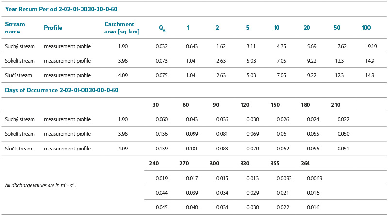
The hydrological characteristics of the individual basin closing profiles are shown in Tab. 1.
Tab. 1. Basic hydrologic characteristics of Suchý, Sokolí, and Slučí brook catchments
DATA AND METHODS USED
The scope of this article does not allow for the presentation of all results; therefore, the authors have focused on presenting those results that illustrate changes in the runoff regime following disaster decay and regeneration of stands. For the same reason, the results of the MIKE SHE and HEC-HMS model simulations will also be presented, which are most often used in rainfall-runoff modelling due to the complexity of the methods and the possibility of schematization in semi-distributed and fully distributed modes. For clarity of the models, the following data was used:
- DMR 5G ČÚZK;
- The actual geodetic measurements;
- Vegetation cover according to ZABAGED and vegetation data according to ÚHÚL and VÚLHM data;
- Soil data from VÚMOP;
- Measurement of volumetric soil moisture from VÚLHM and CHMI;
- NDVI satellite data and Moisture Index (Copernicus/Sentinel);
- Measurement of precipitation and other meteorological elements from VÚLHM and CHMI;
- Measurement of water levels and flows from VÚLHM and CHMI.
The location of sensors in individual river basins is shown in Fig. 1.
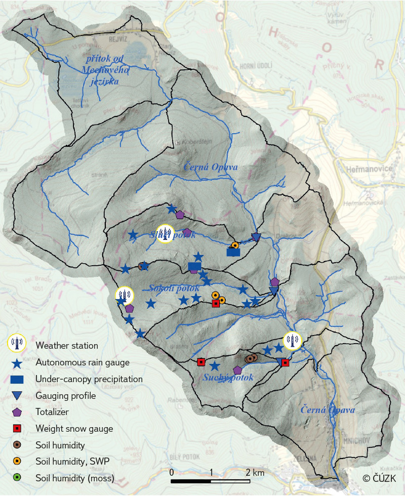
Fig. 1. Distribution of sensors and water gauges on the pilot catchments of Suchý, Sokolí, and Slučí brooks
The models were calibrated for several rainfall-runoff episodes, including those older than the project time scale. One of these calibration episodes is illustrated by the hydrograph for the closing profile of the entire Mnichov basin in Fig. 2.
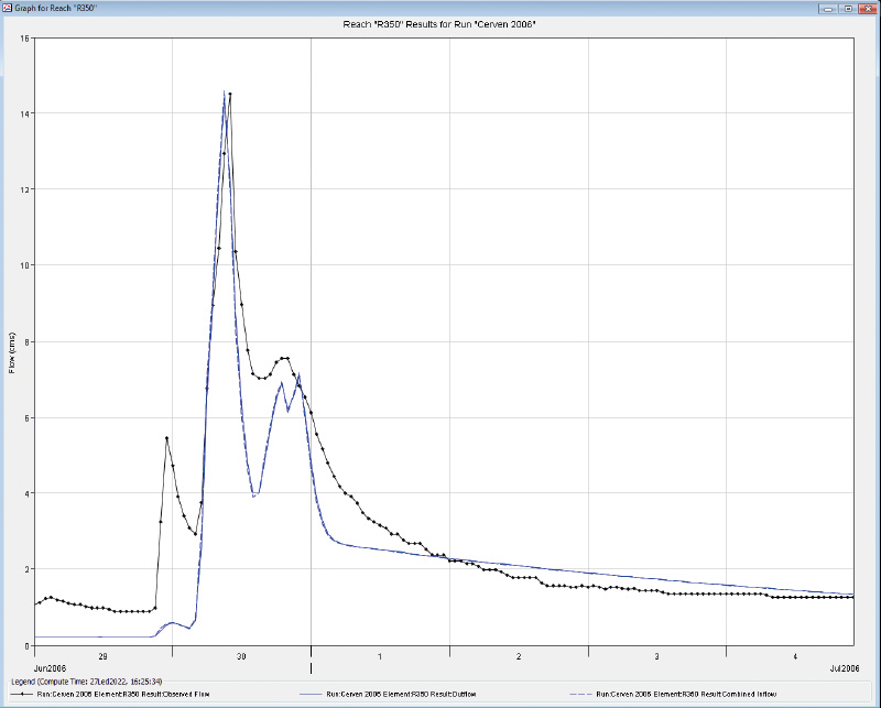
Fig. 2. Calibration of the HEC-HMS model for the rainfall-runoff episode June 2006 and closing profile Černá Opava/Mnichov
SELECTED RESULTS
A s mentioned in the introduction, one of the project specifics is the measurement of volumetric soil moisture on polygons including soil with and without moss cover. For higher representativeness of the measurement, these polygons are located at the interface of forest and open area. The current measurement period does not allow for generalization of the results; however, from the data already available, it is clear that during precipitation episodes, the soil under moss is about 20–30 % less saturated (most likely due to retention of rain water by moss, see Fig. 3) and volumetric soil moisture is about 5–20 % lower during precipitation episodes and just after they subside under forest vegetation cover, probably due to water uptake by the root system and transpiration of the stand. In contrast, in precipitation-free episodes they are slightly higher, probably due to lower surface temperatures and evaporation. This dynamics is shown in Fig. 3. In the following years, the project team wants to focus more on this issue, also from the point of view of the morphology and species structure of the moss layer and vegetation cover on these polygons.
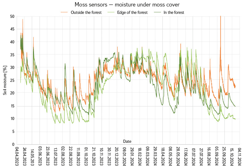
Fig. 3. Volumetric soil moisture under moss cover in the forest, forest edge, and outside the forest
Fig. 3 also shows significant soil profile saturation during the extreme flood of 13–16 September 2024; then, the sensors in the forest stand and on its edge measured approximately 20% of the soil profile saturation, while the sensor in the open area measured a maximum saturation of 50 %. In this context, the original argument of forest hydrology about the attenuation of flood flows by forest stands arises again. Of course, this hydric forest function also has its limits, but this discussion is beyond the scope and content of this article. Despite all the complexity of the links in the forest ecosystem, the results to date point to the fact that the forest hydric function is essential in the landscape, which is also demonstrated by the works mentioned in the introduction or the study by Krečmer et al. [15]. However, the fact remains that during extreme rainfall and floods, the retention capacity of forest soils is exceeded and, similarly to other types of land (fields, meadows, etc.), surface runoff dominates. The peak flow on the Mnichov profile was reached on 15 September 2024 at 8:50 CET, with a value of 168 m3 · s-1, which corresponds to the thousand-year water Q1000 and a specific runoff of 3.30 m3 · s-1· km-2.
The results of the MIKE SHE model simulation for the flood of 14–15 September 2024 for one of the points of the moss sensor polygon on the Slučí stream are shown in Fig. 4. It is evident here that the MIKE SHE calibrated for the basin closing profile similarly simulated extreme saturation values of up to 50 %.
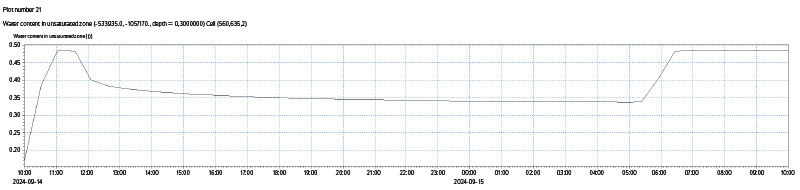
Fig. 4. Soil water volumetric content in 10 cm depth during the rainfall episode 14–16 September 2024 simulated by MIKE SHE model
The simulation results, specifically simulated values of volumetric soil moisture and so-called return flow (exfiltration or exit of the groundwater level above the ground level), are shown in Figs. 5 and 6. The intensity of stream bed and bank erosion and the movement of sediments and coarse fractions are shown in Figs. 7 and 8.
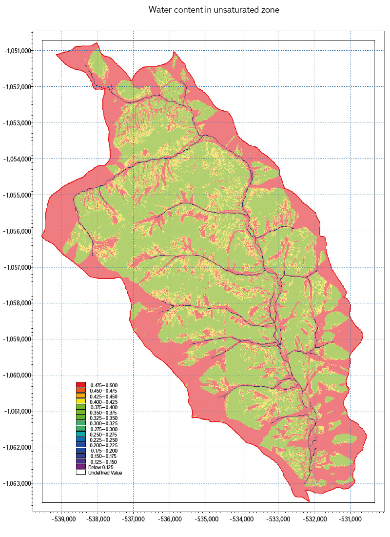
Fig. 5. Volumetric soil moisture content for the rainfall episode 14–16 September 2024 simulated by MIKE SHE model
Fig. 6. Return flow values for the rainfall episode 14–16 September 2024 simulated by MIKE SHE model
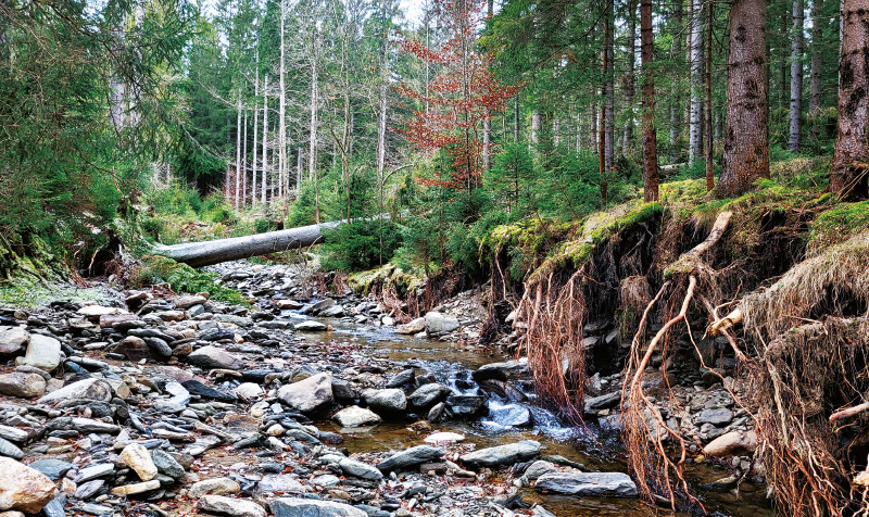
Fig. 7. Bank and river bed erosion accelerated by the extreme flood in September 2004 on Sokolí brook (photo: J. Unucka)
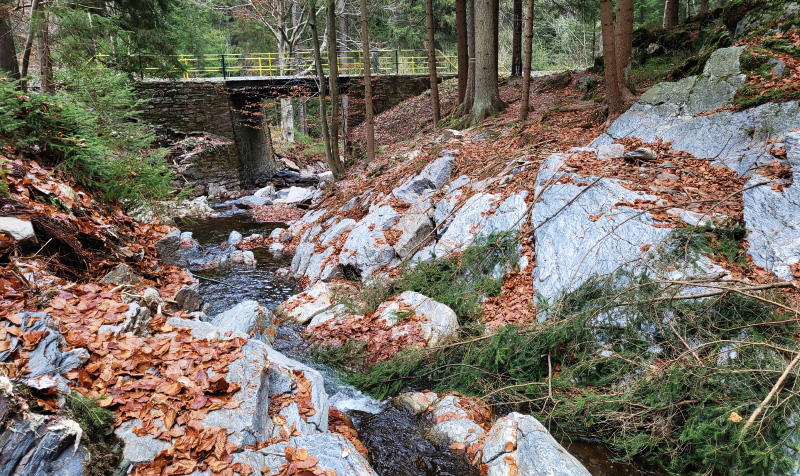
Fig. 8. Accelerated erosion by flood in September 2024 caused particular destruction of the rock steps in the channel of Slučí brook (photo: J. Unucka)
DISCUSSION
Water dynamics in forest stands and basins is undoubtedly a complex phenomenon, which is also influenced by a number of other factors, especially morphometric conditions of the basin (such as hypsographic curve, longitudinal profiles of thalwegs, exposures and slopes of the relief), geological and hydrogeological conditions of the basin, and soil cover where the hydrological transformation of precipitation into runoff dominantly takes place. Likewise, these relationships cannot be simplified to just two extremes – forest and glade. It is necessary to consider the age and species composition of the forest, and the state of the shrub and herb layers. The shrub and herb layers also play a key role in terms of the transformation of runoff and the protection of the soil profile after forest clearance. Nevertheless, the influence of these changes is indisputable, which is supported by the results in other literature, in addition to the works cited in the introduction, such as [16–19]. A specific feature of forest catchments is the role of the moss layer on the hydrological transformation of atmospheric precipitation and soil moisture dynamics. There are not many case studies from real catchments on this issue, rather articles describing laboratory experiments. Papers focusing on the influence of moss on the dynamics of runoff in the catchment include [20 and 21]. The influence of the depths of measuring volumetric soil moisture under moss cover is also discussed in [21]. The combination of measurements, spatial analyses, and modelling in GIS and hydrological modelling as the most effective set of tools and methods for understanding the dynamics of forest catchments cannot be questioned, which can also be found in literature [1, 2, 5, 12 or 22]. The latter work specifically discusses the suitability of the MIKE SHE model for such analyses. For all such analyses, the spatial and temporal context of experiments and studies plays a crucial role. Forest catchments are, with some exceptions, small catchments with an area of a few hectares or square kilometres. The results from these basins cannot be automatically applied to other basins with different climatic, geological, or morphological parameters. Similarly, the results of measurements and simulations in models over a period of four years cannot be generalized – also considering the fact that the standard reference period for deriving hydrological characteristics according to ČSN 75 1400 is 30 years.
CONCLUSION
The team of authors aimed to introduce readers to interesting aspects of forest hydrology in experimental catchments in the Jeseníky Mountains, present research methods, and select interesting results with regard to new procedures or the extreme flood in September 2024. These time series are too short for generalization and, in addition, the entire cycle of forest decay and regeneration, whether spontaneous or controlled, has not yet been completed. Experience from other basins where forestry-hydrological research by VÚLHM and CHMI has been ongoing for a long time (e.g., U dvou louček in the Orlické Mountains, Červík and Malá Ráztoka in the Beskydy Mountains) points to the fact that the combination of in situ measurements and mathematical modelling brings the best results. However, it is necessary to consider the uncertainty of input data and methods. The uncertainty of input data can be reduced by selecting suitable basins and representative areas for monitoring hydrometeorological elements. The uncertainty of the methods can be reduced by choosing an appropriate measurement technique (ideally with the possibility of evaluating uncertainties directly during the measurement, e.g. with the YSI FlowTracker2 device) and the mathematical models themselves. In this category, it is appropriate to choose verified and validated tools. CHMI has good experience in operational practice with the HEC-HMS and MIKE SHE models (hydrological forecasting and hydrological studies), therefore they were quite logically preferred. In this regard, it is also worth mentioning that open source GIS tools such as GRASS GIS or SAGA GIS offer much greater possibilities for morphometric and spatial analyses than the ESRI ArcGIS platform. Finally, it is worth mentioning the fundamental fact of the catastrophic flood of September 2024, which de facto interrupted a series of observations of the destruction of water gauge profiles and intensive remodelling of the hydrographic network. Nevertheless, both VÚLHM and CHMI want to continue forestry and hydrological research in these basins, as they consider these results to be essential both in the context of water and forest management and the ecology of mountain basins.
Acknowledgements
The authors would like to thank the projects NAZV No. QK22010189 “The impact of deforestation on the water regime of small river basins (DEFOREST)” and NAZV No. QL24010054 “The impacts of climate change on small forest river basins and the possibilities of their mitigation through forestry management and water management measures”, without whose support writing the article would have taken much longer and would have been much more complicated. We also want to thank to the DKRVO (Long-term concept of the development of the research organization for the period 2023–2027) of CHMI, especially to areas 6 and 12 focused on improving methods and tools of hydrological modelling and the use of remote sensing data in hydrology and environmental applications.
