ABSTRACT
This article focuses on mapping the development of the lowland landscape over the last 180 years, related to pressures to use lowland areas for economic purposes, including transformation of wetland habitats (specifically ponds) into arable land. The Polabí lowland was chosen as the study area because it is currently affected by a lack of water and there is an occurrence of seasonal drying up of small watercourses. This issue will probably be of greater significance in the future, particularly in the context of the expected continued extreme climatic phenomena. Within the Polabí lowland, the results from the Pardubice region (where the biggest change in pond locations occur) are presented here. The area of all types of ponds (according to their stability) makes up 6.83 % of the study area. According to their occurrence from the Second Military Mapping (1836–1852) up to 2022, the ponds were divided into disappeared, continuous, and new. Disappeared ponds have the largest representation – about two-thirds of the total pond area according to stability. They are followed by continuous ponds, and the smallest area is represented by new ponds. The historical, or more precisely, disappeared ponds were more robust than the present ones, i.e., they had a larger average size. Analyses show that almost half of the disappeared ponds have been replaced by arable land.
INTRODUCTION
The main goal of this article was the mapping of ponds in Pardubice region in the 19th century and at present. In addition to newly created ponds, continuously used preserved ponds and sites of disappeared ponds were found by comparing their occurrence, including their current land use. These results should be a suitable basis for the potential restoration of wetlands, or for the construction of small water reservoirs at suitable locations in the study area.
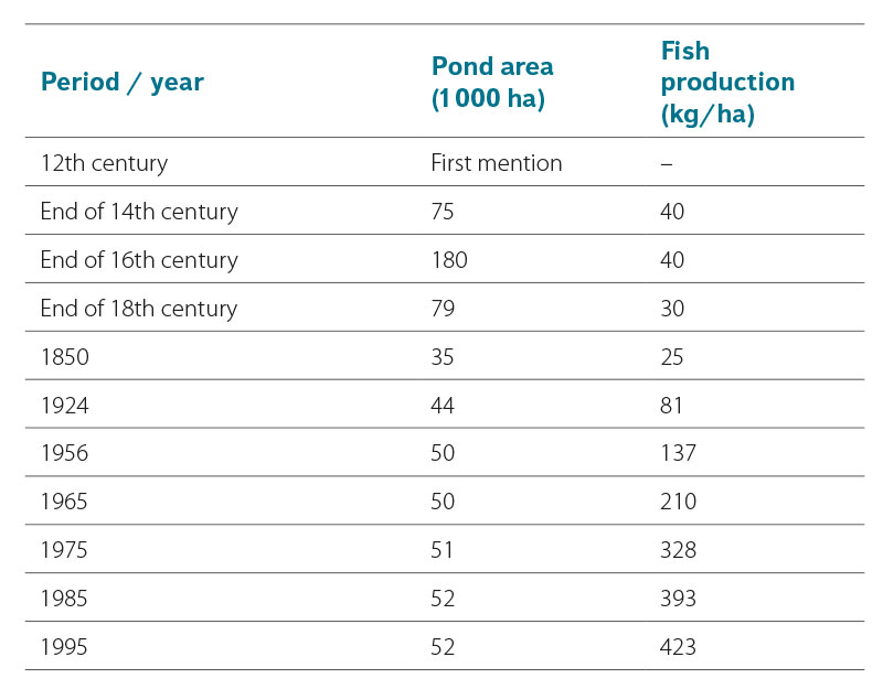
The first mentions of ponds on the area of the current Czech Republic date back to the 12th century. The ponds occupied the largest area at the end of the 16th century (180,000 ha); at the end of the 18th century it was only 79,000 ha, and in 1850 it was 35,000 ha, which is the lowest recorded area of ponds. After that, their area increased slightly and since 1956 it has been around 50,000 ha. However, the change in the amount of fish production per hectare is striking, increasing more than tenfold from the Middle Ages to the present [1] (Tab. 1).
Tab. 1. The development of ponds in the Czech Republic. Data source: Přikryl 2004 [1]
In the past, there was a more extensive and complex system of ponds in the Polabí lowland – especially in the Pardubice region – than in the Třeboň region. While in the Třeboň region the majority of ponds have been preserved, in the Polabí lowland the ponds were largely landfilled in order to grow agricultural crops [2]. In the second half of the 19th century, sugar beet was the main crop grown in the lowlands; in addition to Polabí, also especially in the Morava and Dyje basins in South Moravia [3]. The reason was that sugar beet achieves the highest yields in the warm and slightly humid climate of the region on certain soil types, namely black earths, brown earths, and fluvisols. This combination is usually found in the lowlands [4], which was due to the fact that the development of beet cultivation increased the demand for heavy, wet soils. As a result, there was large-scale loss of ponds in wider flat floodplains. At that time, ponds remained only in colder production areas, in narrow valleys, and in extremely wet places [3, 5]. Since the mid-19th century, sugar industry became the most important branch of food industry in both Bohemia and Moravia [6], where the Kyjovka, Prušánka, and Trkmanka basins in the Hodonín district were similar to Polabí in terms of sugar beet cultivation and the presence of sugar factories [3]. In Polabí, after 1870, the sugar beet crop area was increased the most in the judicial districts of Kolín, Poděbrady, Pardubice, Chlumec nad Cidlinou, Nový Bydžov, Kutná Hora, and Holice [7].
In the course of the 20th century, there was a gradual reduction in the area planted with sugar beet and, in connection with this, sugar mills were also closed down. In Polabí lowland, several dozen sugar factories (e.g., in Pardubice, Hrochův Týnec, Čáslav, Kolín, Ratboř, Pečky,Velim) that were built there in connection with sugar beet cultivation [7–9] were closed down relatively recently. Currently, the cultivation of cereals, maize, and rapeseed dominates the Polabí lowland.
STUDY AREA
The results presented here are part of a wider research concerning the Polabí lowland, where the areas with the greatest changes in the occurrence of wetlands, ponds (as one of the wetland types), small-scale protected areas, and well-preserved sections of watercourses were selected.
The area of the Polabí lowland is not completely defined in any available source. From the many known definitions of the Polabí lowland, the area from Jaroměř to the confluence of the Labe and the Vltava near Mělník was chosen. The area of interest was determined by the boundaries of 4th order hydrological basins [10] in combination with the typology of the current landscape of the Czech Republic [11]. Only the 4th order hydrological basins in the warm landscape of the lowlands (according to the mentioned typology) were taken into account. The selected area of the Polabí lowland consists of 512 fourth order hydrological basins with a total area of 424,613.78 ha (Fig. 1).
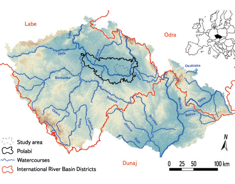
Fig. 1. The study area in the Pardubice region within Polabí lowland
The areas of Pardubice and Poděbrady were identified as sites with the largest representation of historical, or of current ponds, within the Polabí lowland. This article presents the results for the Pardubice region; Poděbrady region will be presented in a follow-up article in the next issue of VTEI journal.
The study area of Pardubice region is located on the outskirts of Pardubice and includes the surroundings of Lázně Bohdaneč and Chlumec nad Cidlinou. The defined area of Pardubice region (Fig. 1) consists of 56 fourth order hydrological basins with a total area of 50,104.5 ha, i.e., it occupies approximately one eighth of the Polabí lowland. These 4th order basins belong to the following 3rd order basins: 1-03-01 Labe from Orlice up to Loučná, 1-03-04 Labe from Chrudimka up to Doubrava, 1-04-02 Cidlina up to Bystřice, 1-04-03 Bystřice, 1-04-04 Cidlina from Bystřice up to the mouth and Labe from Cidlina up to Mrlina, and 1-04-05 Mrlina and Labe from Mrlina up to Výrovka [10].
METHODOLOGY
The first step was the selection and subsequent comparison of the current and historical state of new, continuous, and disappeared ponds in Polabí based on map interpretation.
The map of Second Military Mapping was selected for the primary detection of the occurrence of ponds. The current Basic Map of the Czech Republic 1 : 10,000 (BM 10) and the current orthophoto map of the Czech Republic were primarily used to show the current state of ponds and other water bodies.
The next step was a field survey of sites with the largest proportion of historical and current ponds to verify their current condition, or the state of the sites of disappeared ponds.
MAPS USED
The basic document for the creation of a vector layer for the analysis of the development of ponds in the study area was the map of Second Military Mapping (showing the state of the area between 1836 and 1852 on a scale of 1 : 28,800), available on the CENIA Geoportal as a WMS service [12] to show the historical state of the area. To approximate the state of the landscape before the Second Military Mapping, the map of First Military Mapping was used (showing the state of the area from the 1860s to 1880s on a scale of 1 : 28,800), which can be found in the map browser on the Arcanum Maps – The Historical Map Portal [13] website. Müller’s map of Bohemia from 1720 is the easiest to find in the map browser of the Land Surveying Office archive [14]. Both mappings do not yet have precise geodetic foundations; however, water bodies are shown to identify their historical occurrence.
For the analysis of the current state, the orthophoto map of the Czech Republic (showing the state from 2021), ZABAGED®, and the Basic Map of the Czech Republic 1 : 10,000 (BM 10) were used, all available on the ČÚZK Geoportal [15] as a WMS service.
As part of processing these map and tabular outputs, the results regarding the change in area and location of ponds are presented here. According to stability, the ponds were classified as continuous, disappeared, and new. In the event that a historical pond was preserved on a smaller area, the preserved area of this pond was classified as a continuous pond, and the replaced (disappeared) area of the same pond was classified as a disappeared pond. A similar procedure was followed in the event that the pond area was larger than in the past. For all analyses, only polygons with a minimum size of 0.01 ha were used to minimize spatial imprecision.
As part of the analysis of landscape changes, only ponds were taken into account; other water bodies were not included, such as drinking water tanks, swimming pools, fire tanks, water bodies in former quarries, and water bodies created by sand or brick clay mining, etc.
RESULTS
During the initial visual detection and subsequent analysis of changes in the location of ponds in the Polabí lowland using the Second Military Mapping maps and current maps (BM 10 and orthophoto map), two areas with the largest proportion of historical and current ponds were selected, namely in the Pardubice and Poděbrady regions.
Results for the Pardubice region are presented here. When looking at the study area on the map of Second Military Mapping and the current BM 10, it is clear that there has been a decrease in the area of ponds and, in particular, the disappearance or reduction of large pond areas (Figs. 2 and 3). Müller’s mapping and the First Military Mapping show that in the Pardubice region there was a greater representation of ponds during the 18th century than in the mid-19th century. The robust Rutvas pond near Chlumec nad Cidlinou is worth mentioning, which is no longer found on the map of Second Military Mapping (Figs. 4 and 5).
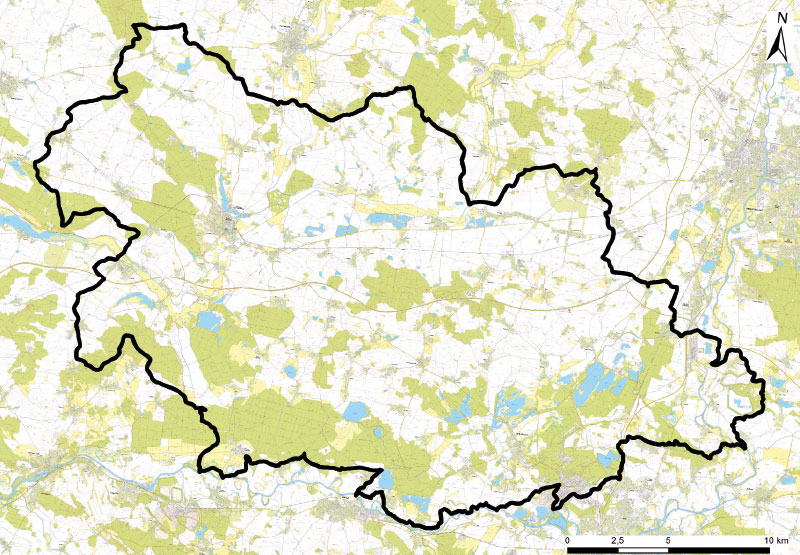
Fig. 2. The researched area in the Pardubice region on current BM 10
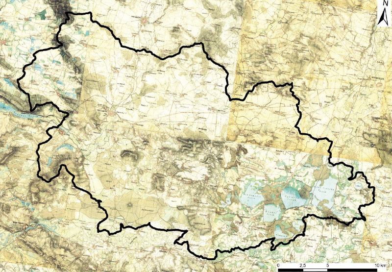
Fig. 3. The researched area in the Pardubice region on a map of the Second military mapping
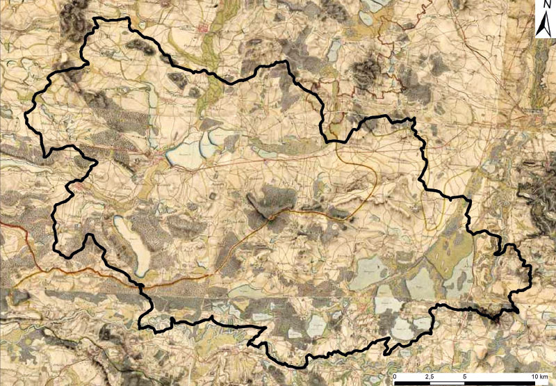
Fig. 4. The researched area in the Pardubice region on a map of the First military mapping
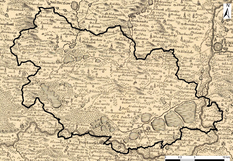
Fig. 5. The researched area in the Pardubice region on the base of Müller’s mapping
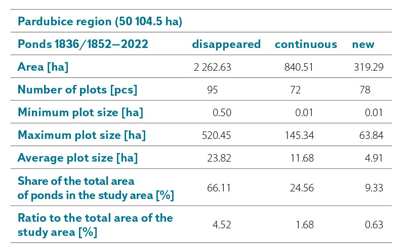
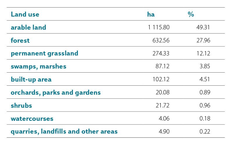
The area of all types of ponds according to stability makes up 6.83 % of the study area in the Pardubice region. Disappeared ponds have the largest representation – 66.11 % of the area of all ponds according to stability (2,262.63 ha). Continuous ponds follow with 24.56 % (840.51 ha) and new ponds represent the smallest area with 9.33 % (319.29 ha) (Fig. 6, Tab. 2). The average area of disappeared ponds is 23.82 ha, continuous ponds 11.68 ha, and new ponds only 4.91 ha. The minimum size of the area of continuous and new ponds is identical to the minimum size that was considered during the data analysis, for disappeared ponds it is 0.5 ha. For the maximum size of the area, it also applies that the most robust were the disappeared ponds, the least robust are the new ponds (Tab. 2).
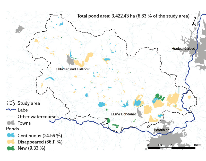
Fig. 6. Development of pond location in the Pardubice region
Tab. 2. Landscape-ecological characteristics of pond development according to stability in Pardubice region
Arable land currently covers 49.31 % of the area of disappeared ponds, and the share of forest land and permanent grassland (27.96 % and 12.12 %, respectively) is also significant. Swamps and marshes replaced 3.85 % of the area of the disappeared ponds, while built-up areas accounted for 4.51 % of their area. Other land use types at the sites of disappeared ponds do not exceed 1 % of their total area (Tab. 3).
Tab. 3. Current land use types at sites of disappeared ponds in Pardubice region
Although almost half of the area of disappeared ponds is occupied by arable land, there is a large proportion of their replacement by forest land. The most extensive of them is the area of the disappeared ponds Oplatil, Rozkoš, and Velká Čeperka between Pardubice, Lázně Bohdaneč, and Opatovice nad Labem (Fig. 7).
 Fig. 7. Sites of historical ponds Oplatil, Rozkoš, and Velká Čeperka based on the current orthophoto map of the Czech Republic
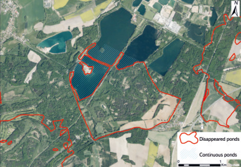
The current state of part of this territory, or the state in August 2022 (at the time of field surveys in Pardubice region in the area of disappeared ponds), is shown in Figs. 8–11. These are the current ponds Oplatil I and II and Malá Čeperka. While the Oplatil I and II ponds are located partly on the site of the historical Oplatil pond and partly on the site of historical marshes and wet meadows, Malá Čeperka pond is entirely located on the site of historical marshes and wet meadows in the vicinity of the site where the Velká Čeperka pond was located. On the site, there are currently several water bodies created by gravel-sand mining, and there is also a cottage settlement. Today, this site is used both for recreation and gravel-sand mining. The historical pond Rozkoš is now almost entirely afforested.
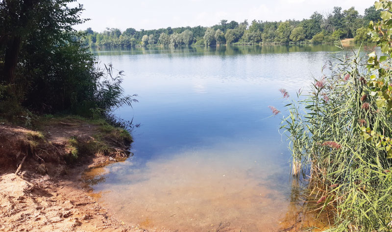
Fig. 8. Oplatil I. pond (August 2022)
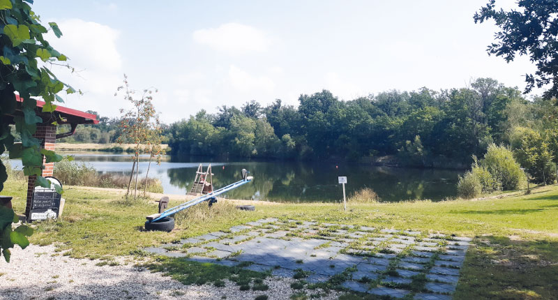
Fig. 9. Recreational use near the Machač water reservoir, created by gravel-sand mining (August 2022)
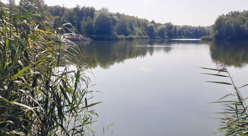
Fig. 10. Malá Čeperka pond (August 2022)
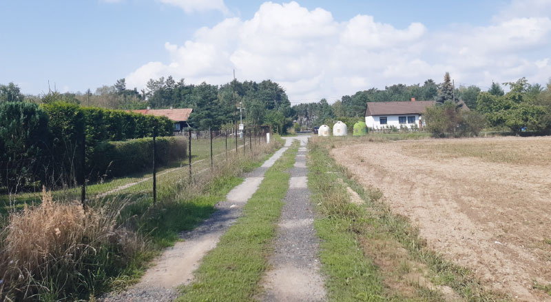
Fig. 11. One of the access roads to the Malá Čeperka cottage settlement (August 2022)
One of the most extensive sites where ponds have been replaced mainly by arable land is the landscape to the east of Chlumec nad Cidlinou, where the Second Military Mapping map recorded Chlumecký, Písecký, and Kosický pond. In these areas, on arable land (but also on permanent grassland), there are visible signs of seasonal waterlogging both at the site of disappeared ponds and in their vicinity, at the site of the historical occurrence of swamps and wet meadows (Fig. 12). The current state of the landscape at the site of the disappeared Chlumecký pond, or in March 2023, is shown in Figs. 13–15. It is a permanent grassland showing signs of waterlogging, partly with reeds, near Nové Město. Furthermore, the current state of the landscape used as arable land near Chlumec nad Cidlinou is shown, where waterlogged sites are also partially covered with reeds.
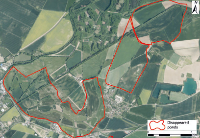
Fig. 12. Sites of disappeared ponds in the Chlumec nad Cidlinou area based on the current orthophoto map of the Czech Republic
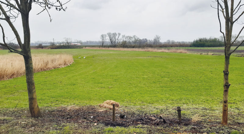
Fig. 13. The current state of the landscape on the site of the disappeared Chlumecký pond near Nové Město (March 2023)
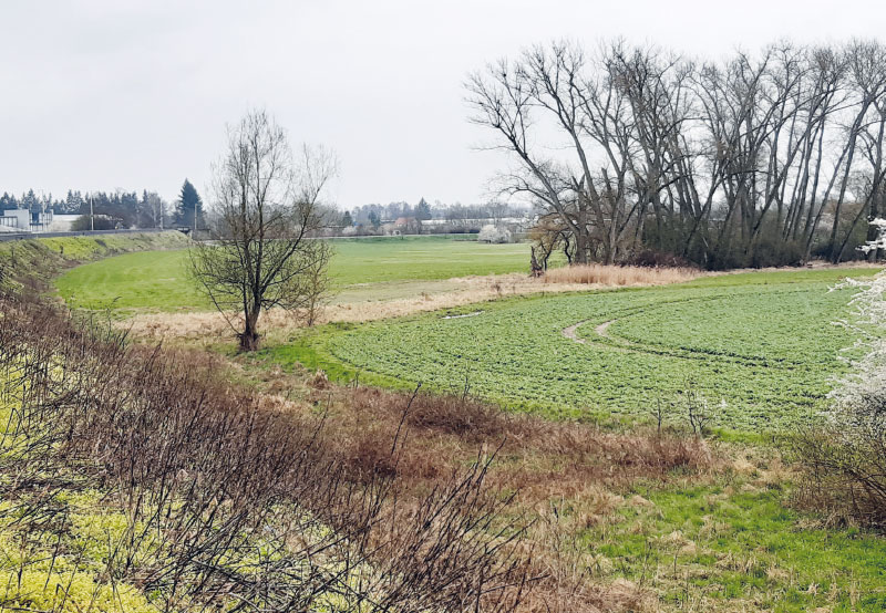
Fig. 14. The current state of the landscape on the site of the disappeared Chlumecký pond near Chlumec nad Cidlinou (March 2023)
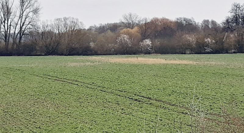
Fig. 15. Waterlogged arable land on the site of the disappeared Chlumecký pond near Chlumec nad Cidlinou (March 2023)
DISCUSSION
While in the past all man-made water bodies equipped with a dam or excavated by human activity were considered ponds [2], nowadays there are a large number of types of water bodies according to use and no official database is known to distinguish ponds from other water bodies. Even in the mid-19th century, the difference between a reservoir (fire, household, etc.) and a pond
(i.e., a water body intended exclusively for fish breeding) was not yet clearly defined. For this reason, we can consider all water bodies drawn on maps of the Second Military Mapping as ponds [2, 3].
The results from the Pardubice region regarding the area of ponds according to stability do not correspond to the data for the whole of the Czech Republic, which are presented in Tab 1. In Pardubice region, from the mid-19th century to the present, disappeared ponds have the largest representation – 66.11 % of the area of all ponds according to stability, followed by continuous ponds with 36.56 %, and new ponds represent the smallest area with 13.4 %; however, for the entire Czech Republic it is stated that the smallest area of ponds was in the mid-19th century and has been increasing slightly since then. This difference is probably due to the fact that, in the lowlands, there was generally pressure for further removal of ponds only in the second half of the 19th century in connection with the sugar beet cultivation [2–7]. Two thirds of the sugar beet production in Bohemia was grown in Polabí. For this reason, ponds disappeared in the second half of the 19th century, although a large number of them had already disappeared [2, 16], which is evident, for example, from the maps of the First Military Mapping and Müller’s mapping. In Figs. 3–5, this trend is also confirmed for the Pardubice region.
The methodology used in landscape ecology (e.g., in the study by Skaloš et al. [17]) was chosen for the categorization of ponds according to stability into disappeared, continuous, and new. In the event that a historical pond was preserved on a smaller area, the preserved area of this pond was classified as a continuous pond, and the disappeared area of the same pond was classified as a disappeared pond. And similarly, if the area of a pond was larger compared to the past, this area was classified as a new pond. On the other hand, in the project dealing with historical ponds of the Czech Republic, the area and location of a specific historical pond recorded on the Second Military Mapping was considered a starting point, and for present interpretation, it was assigned the attribute of a continuous pond (in approximately the same extent / in a significantly smaller extent / in significantly larger extent) or a disappeared pond (completely disappeared / currently only very small / currently a different type of water body) [2, 18]. The given data show that new ponds were not considered and that the area of a specific historical pond was in no case divided into a continuous and disappeared part. However, this project has initial comprehensive information about the location of historical ponds.
CONCLUSION
The area of all types of ponds (according to stability) makes up 6.83 % of the defined area of Pardubice region. Disappeared ponds have the largest representation – a total of 66.11 % of the pond area according to stability (2,262.57 ha). Continuous ponds follow with 36.56 % (840.51 ha) and new ponds have the smallest area with 13.4 % (319.29 ha). The average area of disappeared ponds is 23.82 ha; for continuous ponds it is 11.68 ha, and for new ponds only 4.91 ha. Arable land currently covers 49.31 % of the area of disappeared ponds, the share of forest land and permanent grassland is also significant (27.96 % and 12.12 %, respectively). Swamps and marshes replaced 3.85 % of the area of the disappeared ponds, while built-up areas make up 4.51 % of their area. Other land use categories occupy only small areas in the places of disappeared ponds.
The results presented here contribute to the understanding of the dynamics of changes in ponds at the landscape level and are important for basic research in landscape ecology. From a practical point of view, the presented results can be a source of inspiration for those who decide on the management of ponds in a landscape context. The use of this study for the restoration of ponds in the places of their historical occurrence (disappeared ponds) is very specific. It can therefore be reasonably assumed that such sites are optimal in terms of functional landscape parameters and management of ponds as one of the wetland types. In the past, there have been major changes in terms of the use of the landscape in this area, mainly caused by intensive agricultural activity and the associated modifications of watercourses and land reclamation. Therefore, there is significant scope for designing landscape changes in the catchment area in order to retain water in the landscape. One of the possibilities offered is the restoration of ponds, i.e., one of the types of wetland habitats as one of several ways of combating drought.
Acknowledgements
This article was created as part of the TGM WRI internal grant No. 3600.54.03/2022 “Water in the landscape as an indicator of land changes in the Polabí lowland” and as part of research by the Centre for Landscape and Biodiversity (Technological Agency of the Czech Republic SS02030018).
The Czech version of this article was peer-reviewed, the English version was translated from the Czech original by Environmental Translation Ltd.
