

ABSTRACT
This article presents the methods and results of an assessment of the security of water abstraction and minimum flows for 2050, taking into account the potential impacts of climate change on water resources and projected water demand based on socioeconomic development forecasts. The study covered the entire Czech Republic. The smallest spatial scale used was that of water bodies used in water management planning. The study employed simulation modelling methods (for assessing surface water resources), water balance methods, and procedures for assessing the quantitative status of groundwater bodies. The potential impacts of climate change on water resources were considered using combinations of eight climate models (CMCC-ESM2, EC-EARTH3, GFDL-ESM4, MPI-ESM1-2-HR, MPI-ESM2-0, TAIESM1, HADGEM2-ES, and ALADIN-CLIMATE/CZ) and five emission scenarios (SSP126, SSP245, SSP370, SSP585, and RCP4.5). Existing reservoirs and water transfer infrastructure, including their capacities, were taken into account. The assessment of surface water resources identified 33 reservoirs (out of 82 assessed) as potentially at risk; these reservoirs secure water abstraction and/or ensure minimum flows in watercourses. Groundwater resources were assessed for 838 groundwater body assessment units (out of 1,220 in the Czech Republic). High risk was identified for 106 units (covering 12.7 % of the country), medium risk for 43 units (6.1 %) and low risk in 689 units (66.3 %).
INTRODUCTION
The availability of water resources and the security of water use requirements (particularly water abstractions) under the potential impacts of climate change have been the subject of numerous studies conducted at various spatial scales over the past two decades. Between 2020 and 2025, these issues were also addressed within Work Package 1 (WP1), Forecasting Water Resource Security in the Czech Republic up to 2050 at the Regional Level under Climate Change, of Project No. SS02030027, Water Systems and Water Management in the Czech Republic under Climate Change (hereinafter referred to as Water Centre project). The objective was to assess water resource security for the year 2050, taking into account the impacts of climate change on water resource capacity and scenarios of future water demand across individual sectors based on projected socioeconomic development. The principal outcome is the identification of potentially vulnerable areas. The assessment was carried out at the national scale. The WP1 workflow is illustrated in Fig. 1.
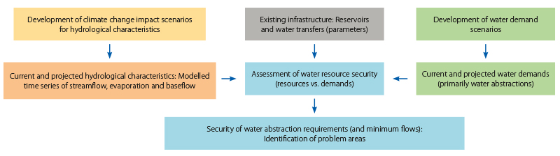
Fig. 1. Methodological framework
It can be divided into three consecutive stages:
- development of water demand scenarios, particularly the forecasting of water abstraction requirements,
- development of climate change impact scenarios for hydrological characteristics and identification of areas with water deficits,
- assessment of the balance between water demands and water resources, taking into account the existing infrastructure (reservoirs, water transfers, and their capacities), followed by an assessment of water resource security and the identification of potentially vulnerable areas.
The development of water demand scenarios is described in [1], while the impacts of climate change on hydrological characteristics are presented in [2]. This article focuses on the final stage of the assessment: evaluating the security of water abstraction requirements and identifying locations that may be at risk of water scarcity in the future. A detailed description of this stage of the assessment is provided in the corresponding research report [3]. A number of organisations collaborated on WP1, particularly in the area of forecasting water demand: the TGM WRI (public water supply and energy sector abstractions; impacts of climate change on hydrological characteristics and identification of water-deficit areas; assessment of water resource security; and identification of potentially vulnerable locations); the University of Chemistry and Technology, Prague (industrial water demand); the Institute of Geology of the Czech Academy of Sciences (water demand for irrigation under climate change impact scenarios); the Czech Technical University in Prague (irrigation); the Czech University of Life Sciences Prague (irrigation and livestock production); and the Czech Hydrometeorological Institute (CHMI, the effects of abstractions and discharges on streamflow). The WP1 activities within the Water Centre project build to some extent on Security Research Project No. VI20192022159, Water Management and Water Supply Systems and Preventive Measures to Reduce Risks in Drinking Water Supply, carried out by the TGM WRI between 2019 and 2022. Unlike WP1 of the Water Centre project, this project was limited to issues related to public water supply systems [4, 5]. Owing to the similarity of the methodologies applied, selected outputs from this project have also been incorporated into the risk assessment results presented in this paper. Detailed descriptions and the results of both projects are available on their respective websites [6] and [7].
METHODOLOGY AND DATA
The forecasting of water resource security focused on assessing the risk of future failure to meet water abstraction requirements and, to a certain extent, minimum flow requirements. The smallest spatial unit adopted for the assessment was the water body, or part thereof, as defined for the purposes of water management planning (a total of 1,118 surface water bodies and 1,220 groundwater body assessment units are defined in the Czech Republic). The methodology and level of detail of the assessment were largely determined by the availability of data. The principal inputs to the water resources–water demands balance assessment were projected water abstraction requirements and projected values of hydrological characteristics affected by climate change. These input data were developed directly within WP1 of the Water Centre project [1, 2] and the Security Research Project [4, 5].
Input data
The following datasets were used in the assessment:
- Projected water abstractions for 2050, disaggregated by calendar month. Source: TGM WRI, University of Chemistry and Technology, Prague; Czech Technical University in Prague; and Czech University of Life Sciences Prague [1].
- Time series of modelled irrigation water demand projected for 2050. Source: Institute of Geology of the Czech Academy of Sciences [1].
- Data on water abstractions, discharges, water storage, and reservoir parameters (active storage volume and minimum outflow) recorded in accordance with Decree No. 431/2001 Coll. Source: River Basin Authorities and TGM WRI [8].
- Data on the proportion of stormwater in discharges to surface waters from the Water Supply and Sewerage Assets and Operations Register (sewer network and wastewater treatment plant sections), maintained in accordance with Decree No. 428/2001 Coll. Source: Ministry of Agriculture [9].
- Time series of modelled monthly streamflow, evaporation, and baseflow from the catchments of gauging stations and the inter-catchment areas of surface water bodies. Source: TGM WRI [2, 4].
- Long-term and annual baseflow values for the hydrogeological zones of the Czech Republic. Source: CHMI.
- Reassessment of groundwater resources. Source: Czech Geological Survey [10].
- Hydrogeological zoning. Project of the Government Council of the Czech Republic for Research and Development No. VaV/650/4/02, Final Summary Report for the 2002–2005 project period. Source: TGM WRI [11].
Hydrological conditions
Given the uncertainties associated with predicting the impacts of climate change on hydrological characteristics, the assessment of water resource availability for 2050 was carried out using multiple scenarios. The hydrological scenarios were defined by combinations of climate models and emission scenarios [2, 4]. An overview of the climate models and emission scenarios considered is provided in Tab. 1. The HADGEM2-ES climate model and the hydrological conditions corresponding to a 2 °C increase in temperature were assessed within the Security Research Project, and their impacts were evaluated only for public water supply abstractions [4]. The remaining climate models and emission scenarios were evaluated as part of WP1 of the Water Centre project [2]. Each combination of a climate model and an emission scenario represents an alternative projection of future climatic conditions. This approach makes it possible to better capture the uncertainties associated with future climate development and to assess the robustness of the results under different climate scenarios.
Tab. 1. Evaluated climate models and emission scenarios
| Climate model | Emission scenario | Note | |
|---|---|---|---|
| CMCC-ESM2 | SSP126, SSP245, SSP370, SSP585 | - | |
| EC-EARTH3 | SSP126, SSP245, SSP370, SSP585 | - | |
| GFDL-ESM4 | SSP126, SSP245, SSP370, SSP585 | - | |
| MPI-ESM1-2-HR | SSP126, SSP245, SSP370, SSP585 | - | |
| MPI-ESM2-0 | SSP126, SSP245, SSP370, SSP585 | - | |
| TAIESM1 | SSP126, SSP245, SSP370, SSP585 | - | |
| ALADIN-CLIMATE/CZ | SSP245, SSP585 | - | |
| HADGEM2-ES | RCP4.5 | Public water supply abstraction | |
| Current climate + 2 °C | - | Public water supply abstraction |
The SSP585 emission scenario is widely interpreted in the current scientific literature as a high-emissions scenario representing the upper bound of potential future climate change. Although some experts no longer regard it as the most likely trajectory of future socioeconomic development, it remains an appropriate scenario for risk assessment and for evaluating the sensitivity of water resources to potentially adverse climate change. Accordingly, in the present study, the SSP585 scenario was not interpreted as the most likely future scenario, but rather as one of several scenarios used to assess the range of potential impacts of climate change on water resource availability.
Water abstraction requirements and minimum flows
In 2021, a total of 5,602 water abstraction points were registered in accordance with [8], with a total annual abstraction of approximately 1,400 million m3 ∙ year-1 (excluding abstractions for water transfers). These comprised 883 surface water abstraction points, with a total annual abstraction of approximately
1,030 million m3 ∙ year-1 (about 74 % of the total volume abstracted), and 4,719 groundwater abstraction points, with a total annual abstraction of approximately 370 million m3 ∙ year-1 (about 26 % of the total volume abstracted). Whereas surface water abstractions are used extensively for public water supply, industry, energy production, and agriculture, groundwater abstractions are used primarily for public water supply.
Water abstraction requirements were considered under two scenarios: current water demand and projected water demand for 2050 [1].
Current water demand was determined as follows:
- Public water supply, energy production, and industrial abstractions were based on recorded monthly water abstraction data for the period 2015–2021. Monthly water demand was calculated as the arithmetic mean of the recorded abstractions for all economic sectors except agriculture.
- Agricultural abstractions were determined as the maximum monthly values recorded during the same period (abstractions for irrigation increase substantially during dry periods).
Projected water demand (the high scenario) was determined as follows: - Public water supply abstractions were based on the average monthly abstractions for the period 2016–2021, adjusted according to the high demographic development scenario.
- Energy sector abstractions were projected for 2050 based on the supporting documents for the national energy strategy.
- Industrial abstractions were determined as the maximum recorded annual abstraction during the period 2009–2021, distributed evenly throughout the year.
- Agricultural abstractions were determined as the maximum abstractions recorded for each calendar month during the period 2015–2021.
- Irrigation demand was represented by time series of monthly irrigation water demand for the inter-catchment areas of surface water bodies for the individual climate models and emission scenarios, using the following variants:
- prevention of drought stress,
- optimisation of crop production.
The security of minimum flows was assessed on the basis of the current minimum reservoir outflow requirements and the active augmentation of minimum flows at downstream control points.
Methodology for assessing surface water resources
The security of surface water abstractions and minimum flows in watercourses was assessed using water balance methods and simulation modelling of the storage function of water management systems. The modelling approach is described in detail in [12]. The model simulates the behaviour of the water management system as a chronological sequence of discrete time steps (a monthly time step was adopted in this study). The simulation is based on time series of natural streamflow (i.e. unaffected by regulation or water abstractions/discharges), water use requirements (water abstractions in this study), minimum flow requirements, the technical parameters of the system components (here, the active storage volumes of reservoirs and the capacities of water transfers), and the operating rules incorporated into the model for regulating outflows (i.e. reservoir operating rules governing releases from active storage). The model outputs time series of simulated variables, including streamflow, reservoir surface evaporation, water abstractions, reservoir outflows, and water volumes and water levels within the active storage zone of reservoirs. These time series are subsequently subjected to statistical analysis. The primary indicator used to express the security of water abstractions is the duration-based security index (Pt), defined in [13] (in simplified terms, it expresses the percentage of the total assessment period during which water abstraction requirements or minimum flow requirements are fully met). Water management simulations were carried out using the “Simulation Model of the Storage Function of a Water Management System” [14], developed by TGM WRI.
In the reference year 2021, the water abstraction register maintained in accordance with [8] included 82 reservoirs and 14 water transfers relevant to the provision of storage capacity, as well as 883 surface water abstraction points. For the assessment, abstraction points with an annual abstraction exceeding 500 thousand m3 ∙ year-1 were selected. A total of 132 abstraction points met this criterion. These abstraction points accounted for approximately 90 % of the total volume of surface water abstracted. The selected abstraction points are shown in Fig. 2. The effects of the remaining (smaller) water abstractions were incorporated into the assessment in aggregated form at the nearest water management system point. Similarly, the effects of all groundwater abstractions (by projecting the abstraction points onto the river network) and water discharges were also incorporated in aggregated form. The water management system also included 16 control points at which the active augmentation of minimum flows by reservoirs was assessed, together with 222 outlet points of surface water bodies, where the potential to meet irrigation demand within the corresponding inter-catchment areas was evaluated.
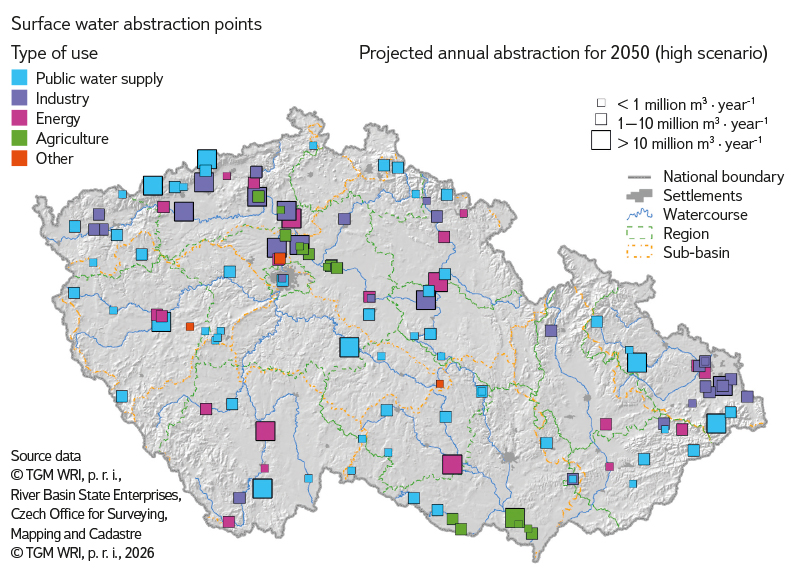
Fig. 2. Locations of significant surface water abstraction
The storage function was simulated for each assessment scenario using a monthly time step and a chronological hydrological dataset comprising time series of modelled natural mean monthly streamflow and evaporation over a period of 30 years (or 60 years in the Security Research Project). For each water abstraction and minimum flow requirement considered, the simulation model then calculated the corresponding security level and compared it with the security level recommended by Czech Standard ČSN 75 2405 [13].
Methodology for assessing groundwater resources
The adequacy of groundwater resources was assessed using water balance methods for evaluating the current and projected status of groundwater quantity [15], together with procedures for assessing the quantitative status of groundwater bodies [16]. A limitation of applying these established nationwide methods was the availability of input data on natural groundwater resources, which were compiled only at the scale of hydrogeological zones (152 in total), with areas of up to 5,800 km². Consequently, the final results could, in practice, represent only part of the assessed area. A new stage of quantitative groundwater status assessment is currently being completed, in which the water balance is calculated directly at the scale of groundwater bodies (174 in total). However, this is based only on the redistribution of natural groundwater resources according to the proportion of each groundwater body’s area relative to that of the corresponding hydrogeological zone. The only exception is the quaternary upper-layer groundwater bodies, for which the methodology for assessing quantitative status has been completely revised. The first project to apply a more sophisticated approach to assessing natural groundwater resources at a finer spatial resolution over a large part of the Czech Republic was the Security Research Project [5], carried out between 2019 and 2022. In this project, the current status and projected changes in baseflow were calculated at the scale of the inter-catchment areas of surface water bodies (1,118 in total), providing data for 825 groundwater body assessment units (out of 1,220) under Variant II. In the Water Centre project, the risk of future inadequacy of groundwater resources for groundwater abstractions was likewise assessed at the level of groundwater working units.
On the groundwater resource side, long-term estimates of natural groundwater resources were taken from the Groundwater Resource Reassessment [10] (covering natural resources with 50 % and 80 % security, as well as exploitable groundwater resources), from data provided by the CHMI (natural resources with 50 % and 80 % security), and, as supplementary information, from the Hydrogeological Zoning 2005 project [11] (equivalent to natural resources with 50 % security). All these values were subsequently downscaled to the smaller groundwater body assessment units using the outputs of the current-state hydrological balance model.
In assessing the risk of insufficient groundwater resources for groundwater abstractions, the impacts of all climate models and emission scenarios on changes in baseflow were first evaluated using spatial analysis. Subsequently, the combination of the ALADIN-CLIMATE/CZ climate model and the SSP585 emission scenario for 2050 (within the Water Centre project), and the HADGEM2-ES climate model and the RCP4.5 emission scenario for the 2041–2060 period (within the Security Research Project), were selected as the representative scenarios.
On the demand side, the groundwater resource balance is based on groundwater abstraction data converted to L ∙ s-1. For the Water Centre project, the following values were determined:
- total annual abstractions for the period 2016–2021 for hydrogeological zones and groundwater body assessment units,
- average annual abstractions for the period 2016–2021 for hydrogeological zones and groundwater body assessment units,
- projected abstractions for 2050, calculated using the methodology developed for the Water Centre project (high scenario).
The Water Centre project included only groundwater abstractions recorded in 2021, expressed as average annual values for the period 2016–2021, whereas the Security Research Project used data for the period 2013–2018. Abstractions for drinking water supply amounted to approximately 308 million m3 ∙ year-1, representing about 82 % of the total volume of groundwater abstracted (from 64 % of the registered abstraction points), while other abstractions totalled approximately 65 million m3 ∙ year-1, accounting for about 18 % of the abstracted volume (from the remaining 36 % of registered groundwater abstraction points). Projected abstractions comprised unchanged non-potable water abstractions together with drinking water abstractions for each water balance unit, adjusted according to the projected demographic development up to 2050. The projected groundwater abstraction requirements based on the expected demographic development to 2050 are shown in Fig. 3.
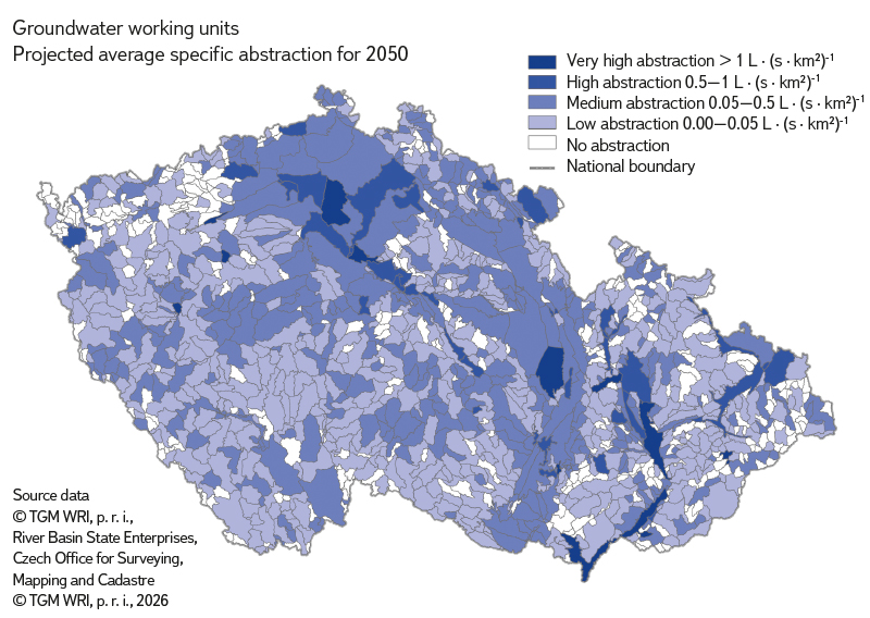
Fig. 3. Projected groundwater abstraction requirements by 2050
Only 271 of the 1,220 groundwater body assessment units, namely those with annual groundwater abstractions of at least 5 L ∙ s-1 in 2021, were included in the water balance comparison of groundwater abstractions and natural groundwater resources. The remaining 949 assessment units were not evaluated in the Water Centre project, just as 395 assessment units had been excluded from the future projections in the Security Research Project. This is because water balance assessments involving very small abstraction volumes are subject to considerable uncertainty.
RESULTS
The procedures described above resulted in an assessment of the adequacy of water resources in relation to water abstraction and minimum flow requirements. Because of the large number of scenarios assessed and the corresponding volume of data, the detailed results are presented in the relevant specialised public database (see below). The results presented here are therefore provided in summary form.
Surface water resources
The assessment of the security of surface water abstractions and minimum flows downstream of reservoirs was carried out for more than 50 scenarios combining the hydrological conditions considered (climate models and emission scenarios) with the required water abstraction volumes.
The risk of failing to meet surface water abstraction or minimum flow requirements by 2050 is expressed for each assessment point, across all scenarios considered, using the following classification:
- High risk: The requirement is not fully met under any scenario, and in at least one scenario fails to achieve the level of security recommended by the standard [13].
- Low risk: The requirement is fully met under all scenarios.
- Medium risk: All other cases.
The results are illustrated in Fig. 4. The reservoirs identified as being at risk, together with the minimum and maximum duration-based security (Pt) achieved for the water abstractions and/or minimum flows they support under the 2050 scenarios, are presented in Tab. 2.
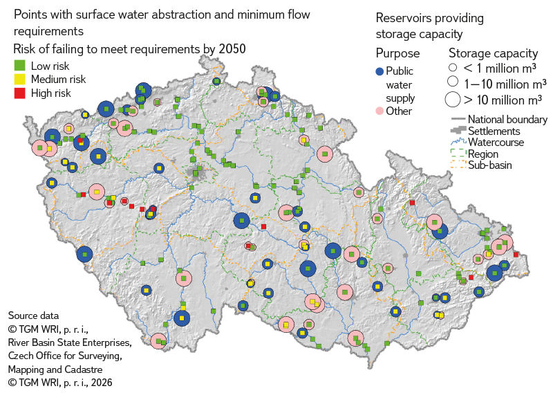
Fig. 4. Risk of failing to meet surface water abstraction requirements and minimum flow rates by 2050
Tab. 2. Water reservoirs at risk of failing to meet surface water abstraction requirements and/or minimum flow rates by 2050
| Reservoir | Watercourse | Water abstraction | Projected water abstraction (thousand m³·yr⁻¹) | Maximum security Pₜ [%] | Minimum security Pₜ [%] | Risk |
|---|---|---|---|---|---|---|
| Březová | Teplá | - | - | 98.8 | 84.4 | high |
| České Údolí | Radbuza | - | - | 99.1 | 84.9 | high |
| Dalešice | Jihlava | other | 54697 | 99.9 | 98.2 | medium |
| Hamry | Chrudimka | public water supply | 328 | 99.9 | 90.5 | medium |
| Hracholusky | Mže | - | - | 99.9 | 99.1 | medium |
| Hubenov | Maršovský stream | public water supply | 3812 | 99.9 | 95.8 | medium |
| Husinec | Blanice | - | - | 99.9 | 94.9 | medium |
| Jesenice | Odrava | - | - | 99.9 | 87.8 | medium |
| Karhov and Zhejral | Studenský stream | public water supply | 217 | 99.9 | 95.9 | medium |
| Klabava | Klabava | - | - | 93.8 | 78.8 | high |
| Klíčava | Klíčava | public water supply | 2858 | 99.9 | 74.4 | medium |
| Koryčany | Kyjovka | public water supply | 705 | 99.9 | 95.2 | medium |
| Les Království | Labe | - | - | 99.9 | 98.8 | medium |
| Lučina | Mže | public water supply | 1324 | 99.9 | 95.2 | medium |
| Ludkovice | Ludkovický stream | public water supply | 434 | 99.9 | 99.8 | medium |
| Luhačovice | Luhačovický stream | - | - | 99.9 | 98.8 | medium |
| Myslivny | Černá | public water supply | 303 | 99.9 | 98.8 | medium |
| Nová Říše | Řečice (Olšanský stream) | public water supply | 980 | 99.9 | 79.4 | medium |
| Obecnice | Obecnický stream | public water supply | 771 | 99.6 | 69.4 | high |
| Olešná | Olešná | other | 3961 | 99.9 | 89.4 | medium |
| Opatovice | Malá Haná | public water supply | 2039 | 99.9 | 96.7 | medium |
| Pilská | Pilský stream | public water supply | 970 | 99.9 | 91.6 | medium |
| Pilská u Žďáru | Sázava | - | - | 99.9 | 95.5 | medium |
| Podhora and Mariánské Lázně | Teplá | public water supply | 585 | 99.9 | 97.8 | medium |
| Římov | Malše | public water supply | 16605 | 99.9 | 99.5 | medium |
| Slušovice | Dřevnice | public water supply | 4907 | 99.9 | 99.1 | medium |
| Stanovice | Lomnický stream | public water supply | 5318 | 99.9 | 96.0 | medium |
| Staviště | Staviště | - | - | 99.9 | 97.1 | medium |
| Tatrovice | Tatrovický stream | other | 3519 | 99.9 | 96.3 | medium |
| Vranov | Dyje | public water supply | 2273 | 99.9 | 98.2 | medium |
| Vrchlice | Vrchlice | public water supply | 3813 | 99.9 | 92.2 | medium |
| Znojmo | Dyje | public water supply | 2377 | 99.9 | 98.1 | medium |
| Žlutice | Střela | public water supply | 2561 | 99.9 | 98.0 | medium |
The Obecnice public water supply reservoir, together with the Březová, České Údolí, and Klabava reservoirs, was identified as being at high risk. A further 29 reservoirs, including 19 public water supply reservoirs, were classified as presenting a medium risk.
Groundwater resources
For the assessment, the critical threshold values for the ratio of groundwater abstractions to natural groundwater resources were adopted from the procedures used to assess quantitative groundwater status, namely 0.4 for natural groundwater resources with 50 % security and 0.5 for natural groundwater resources with 80 % security. For the comparison of groundwater abstractions with exploitable groundwater resources, water balance ratios were not calculated. Instead, the average annual abstractions for the period 2016–2021 were subtracted from the exploitable groundwater resources, and the proportion of the remaining (unutilised) resources relative to the total exploitable groundwater resources was compared with the critical threshold of 20 % (i.e. the result was considered unsatisfactory if the proportion of unutilised resources was less than 0.2).
In addition to assessment units with very small groundwater abstractions, hydrogeological zone 3110 Pavlovské vrchy was also excluded from the water balance assessment because natural groundwater resources have not been quantified for this region by any method, and it does not contain any significant groundwater abstractions.
The synthesis of the individual water balance comparisons between groundwater abstractions and natural groundwater resources (six comparisons for the current state and six for the projected state) gave slightly greater weight, as a precautionary measure, to unfavourable results based on the ratio to natural groundwater resources with 50 % security. The results of the comparisons with natural groundwater resources having 80 % security, and of the comparisons with exploitable groundwater resources, were considered less reliable. Zero abstractions did not, logically, worsen the final status classification, whereas zero natural groundwater resources did. The final synthesis was also adversely affected by the number of water balance comparisons that could not be performed because of the absence of data on natural groundwater resources in assessment units where at least one comparison had produced an unfavourable result.
The water balance assessment resulted in an evaluation of both the current and the projected status (the results for 2050 are shown in Fig. 5). Using the ALADIN-CLIMATE/CZ climate model, the SSP585 emission scenario for natural groundwater resources, and the projected demographic development, relatively few groundwater body assessment units were identified as being at risk. Of the assessment units evaluated, 47 were classified as high risk (covering 6.6 % of the area), 16 as medium risk (1.5 % of the area), and 208 as low risk (39.7 % of the area). The remaining 949 assessment units (52.2 % of the area) were not evaluated because groundwater abstractions were very small (less than 5 L ∙ s-1), resulting in an unacceptably high level of uncertainty.
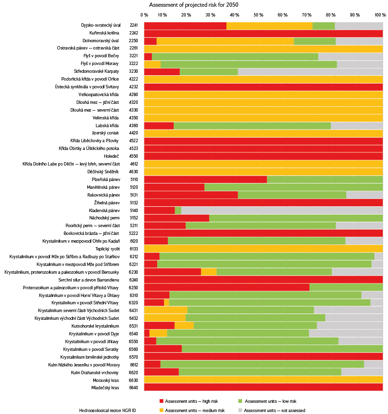
Fig. 5. Proportion of work units (PRJ) at risk of groundwater abstraction shortages by 2050 in hydrogeological zones
For hydrogeological zones in which at least one groundwater body assessment unit was identified as being at risk under the projected conditions, summary statistics were compiled based on the percentage of the region’s area represented by the individual assessment units (see Fig. 6). The proportion of the area that could not be evaluated reached as much as 84.4 % in some hydrogeological zones. Nevertheless, the results clearly showed that the risk assessment can vary considerably within individual hydrogeological zones, demonstrating that assessing future conditions at a finer spatial resolution is worthwhile despite the inherent uncertainties of future projections.
For the ALADIN-CLIMATE/CZ climate model and the SSP585 emission scenario, the total average annual groundwater abstraction during the assessment period 2016–2021 was 11,627 L ∙ s-1, while the total projected abstraction for 2050 was 11,665 L ∙ s-1. Of the total projected groundwater abstraction for 2050, 29.2 % (3,410 L ∙ s-1) was associated with groundwater body assessment units classified as high risk, 5.8 % (681 L ∙ s-1) with medium-risk units, 56.3 % (6,567 L ∙ s-1) with low-risk units, and 8.6 % (1,007 L ∙ s-1) with assessment units that were not evaluated.
Within the Security Research Project, 825 of the 1,220 groundwater body assessment units were evaluated using the HADGEM2-ES climate model and the RCP4.5 emission scenario for the 2050 projection. Of these, 91 assessment units, covering 11.1 % of the Czech Republic, were classified as high risk, 37 units (6.1 % of the country’s area) as medium risk, and 697 units (67.1 % of the country’s area) as low risk (Fig. 6). The remaining assessment units were not evaluated because groundwater abstractions were too small.
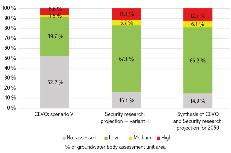
Fig. 6. Comparison of risk assessment results for the ALADIN-CLIMATE/CZ climate model under the SSP585 scenario (Water Centre – CEVO) and the HADGEM2-ES climate model under the RCP4.5 emissions scenario (Security research)
Finally, the results from the Water Centre project and the Security Research Project were synthesised by adopting the more adverse classification from the two assessments for each groundwater body assessment unit. In total, 838 of the 1,220 groundwater body assessment units were evaluated, of which 106 units, covering 12.7 % of the Czech Republic, were classified as high risk, 43 units (6.1 % of the country’s area) as medium risk, and 689 units (66.3 % of the country’s area) as low risk (Figs. 6 and 7). The remaining 382 assessment units (14.9 % of the country’s area) were not evaluated.
Groundwater body assessment units identified as being at risk are shown in the overview map in Fig. 7.
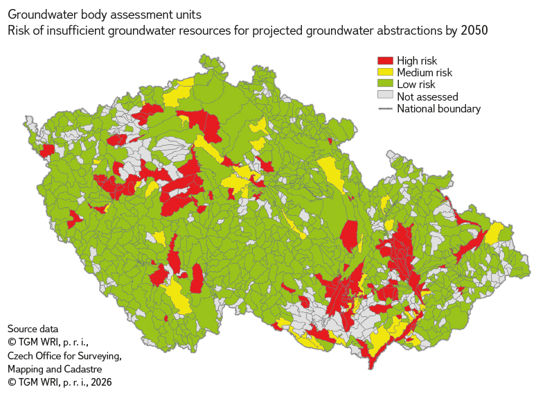
Fig. 7. The risk of insufficient groundwater resources for abstraction by 2050
Public specialised database
The detailed results of the water resource security assessment have been incorporated into the specialised public databases developed within the two projects [17, 7]. The data are available through web-based map services in the form of interactive maps and linked tables. The user interface is shown in Figs. 8 and 9
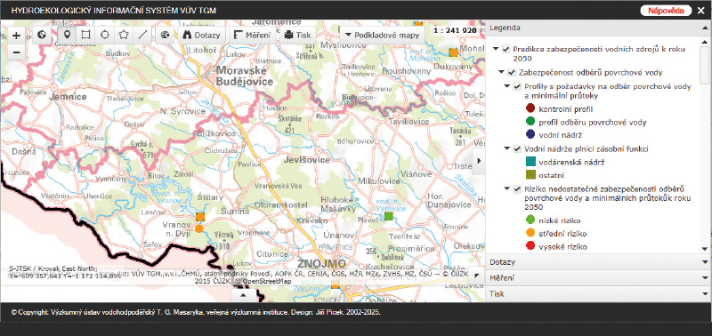
Fig. 8. Browser Service User Interface: Map section
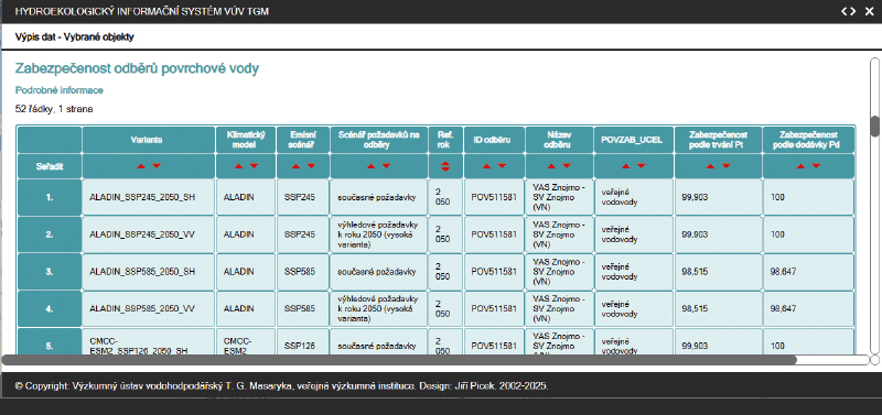
Fig. 9. Browser Service User Interface: Table view
DISCUSSION
Assessing future water resource security is a complex undertaking. Its modelling at the scale of the entire Czech Republic requires a number of necessary simplifications and is subject to considerable uncertainty. The principal sources of uncertainty include the following. The time horizon of 2050 was selected in accordance with the objectives of the Water Centre project and, at the same time, represents a period for which not only the evolution of climatic conditions, but also future water abstraction requirements and the state of water management infrastructure, can still be projected with a reasonable degree of confidence. Extending the projection to 2100 would substantially increase the uncertainties associated not only with climate models, but also with demographic, economic, and technological developments. For this reason, the results should primarily be regarded as a basis for the medium-term planning of climate adaptation measures over the coming decades. They should not be interpreted as a definitive prediction of future conditions, but rather as an assessment of the range of possible future developments under different combinations of climatic and socioeconomic assumptions.
A major source of uncertainty in the assessment results is the prediction of the impacts of climate change on hydrological characteristics and, to a lesser extent, the projection of future water abstraction requirements. This uncertainty is reflected in the use of multiple assessment scenarios. Consequently, the assessed level of water resource security also exhibited a degree of variability (e.g. for the Klíčava, Obecnice, Stanovice, and Hamry reservoirs), with many locations being identified as at risk only under some of the less favourable scenarios. The highest levels of identified risk generally occurred for combinations of climate models with the SSP585 emission scenario, which should be regarded primarily as representing the upper bound of the potential impacts of climate change. This scenario was not interpreted in the present study as the most likely future development, but rather as one of the scenarios used to assess the range of potential future risks to water resources. The assessment of groundwater resources is subject to uncertainties arising from the current estimates of groundwater resources, the heterogeneity of natural groundwater resources within hydrogeological zones, and the approximation of natural groundwater resources under future conditions.
Water abstractions are constrained by the need to preserve the ecological functioning of watercourses. At present, this requirement is addressed by maintaining so-called minimum residual flows. A Government Regulation is currently being prepared that is intended to bring the method for determining minimum residual flows more closely into line with the requirements of the EU Water Framework Directive. In this study, the assessment of minimum flow security was limited to flows actively maintained by reservoirs (i.e. the minimum reservoir outflow and, where applicable, the active augmentation of minimum flows at downstream control points). For the remaining assessment points, no projected minimum flow was determined and, consequently, its level of security was not classified.
Water abstraction requirements are based primarily on an analysis of recorded water abstractions. However, actual water abstractions may not accurately represent current water abstraction requirements, as the volume abstracted can vary in response to a range of factors, such as industrial operating conditions (e.g. plant shutdowns) or drought (e.g. abstraction restrictions resulting from insufficient water resources or increased irrigation demand due to soil moisture deficits). Difficulties in determining water abstraction requirements and the corresponding water sources may also arise in public water supply systems, where water may be abstracted from multiple sources (watercourses or reservoirs), and the volume abstracted from a particular source may vary depending on other operational factors. In addition, the permitted abstraction volume often differs substantially from the volume actually abstracted and, in many cases, is considerably higher.
CONCLUSION
The aim of the assessment described above was to evaluate the security of water abstractions and minimum flows supplied by surface water and groundwater resources under projected conditions for 2050, and to identify potentially vulnerable locations. Water abstraction security was assessed using simulation modelling (for surface water resources), water balance methods, and procedures for assessing the quantitative status of groundwater bodies. The assessment was carried out at the national scale. The principal input data comprised time series of modelled streamflow, evaporation, and baseflow from the catchments of gauging stations and the inter-catchment areas of surface water bodies under projected climate change conditions, together with projected water abstraction requirements. Existing reservoir and water transfer infrastructure, including their capacities, was taken into account. The uncertainties associated with projecting future developments were addressed by considering multiple assessment scenarios. Water abstraction requirements were evaluated for both current recorded abstractions and projected future abstractions. The potential impacts of climate change on water resources were considered using combinations of climate models and emission scenarios. Sources of uncertainty in the assessment include the determination of water abstraction requirements (e.g. the long-term discrepancies between permitted and actual abstraction volumes), the treatment of minimum residual flows, and the interaction between surface water and groundwater. The assessment of surface water resources identified 33 reservoirs (out of the 82 assessed) as potentially being at risk. Groundwater resources were evaluated for 838 groundwater body assessment units (out of the 1,220 in the Czech Republic), of which 106 units, covering 12.7 % of the country’s area, were classified as high risk, 43 units (6.1 % of the area) as medium risk, and 689 units (66.3 % of the area) as low risk. The remaining 382 assessment units (14.9 % of the country’s area) were excluded from the projected assessment because groundwater abstractions were too small (less than 5 L ∙ s-1), resulting in an unacceptable level of uncertainty. For the ALADIN-CLIMATE/CZ climate model and the SSP585 emission scenario, groundwater body assessment units classified as high risk accounted for 29.2 % of the total projected groundwater abstraction for 2050 (3,410 L ∙ s-1 out of a national total of 11,665 L ∙ s-1), while medium-risk units accounted for 5.8 % (681 L ∙ s-1), low-risk units for 56.3 % (6,567 L ∙ s-1), and assessment units not included in the evaluation for 8.6 % (1,007 L ∙ s-1).
The assessment results have been incorporated into the relevant specialised public databases. Despite the uncertainties and necessary simplifications associated with conducting the assessment at the national scale, the identification of surface water and groundwater resources that may be at risk in the future provides a valuable basis for more detailed investigations and the timely preparation of measures to reduce these risks.
Acknowledgements
This article is based on research carried out within Project No. SS02030027, Water Systems and Water Management in the Czech Republic under Climate Change, funded by the Technology Agency of the Czech Republic under Subprogramme 3 – Long-term Environmental and Climate Perspectives of the SS Programme – Programme for Applied Research, Experimental Development and Innovation in the Environment – Environment for Life, and Project No. VI20192022159, Water Management and Water Supply Systems and Preventive Measures to Reduce Risks in Drinking Water Supply, funded by the Ministry of the Interior of the Czech Republic under Programme BV III/1-VS.
The Czech version of this article was peer-reviewed, the English version was translated from the Czech original by Environmental Translation Ltd.
