ABSTRACT
The paper analyses the development of historical water reservoirs (splash dams) in the Low Tatras region based on the interpretation of maps from the mid-19th century to the present. In the past, splash dams served as part of the system for floating timber down the Hron and Váh rivers. They represented a key hydro-technical element that significantly influenced the hydrological regime of rivers and the formation of the mountain landscape. The identification of historical splash dams was based on the analysis of maps of the 2nd Military Mapping (1836–1852), which were compared with current map data (ZBGIS, Orthophotomap of the Slovak Republic) and verified by field research.
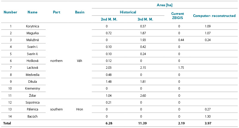
Fourteen splash dams were identified on historical maps. Their total historical area was 6.28 ha (2nd Military Mapping), of which only a small part has been preserved to this day, with an area of 2.19 ha (ZBGIS – current mapping). The results point to a significant decline in historical water areas, with some splash dams disappearing as a result of dam damage, sedimentation, succession, or land use changes, while others have been preserved only in the form of dam relics or have been transformed into new retention reservoirs. The article emphasizes the importance of historical splash dams not only from the perspective of historical-geographical research, but also in the context of current adaptation measures to climate change in mountainous regions.
INTRODUCTION
Natural lakes cover a negligible area in Slovakia and cannot be compared with the largest lakes in neighbouring countries, or in Europe and the world. Nevertheless, they perform an irreplaceable function within the ecosystem of the Western Carpathian landscape, while their economic use is almost zero. For this reason, humans have been constructing water reservoirs in Slovakia since the Middle Ages. From the 14th century onwards, fishponds were gradually established near monasteries; from the 15th century also in sub-castle areas, and subsequently, from the 16th century, the construction of tajchy in mining regions reached its greatest development, serving mining, metallurgical and other technical operations. For the purpose of timber floating from the highest mountain ranges of the Western Carpathians, splash dams were constructed from the 16th century onwards. From the Early Modern period, particularly in the 18th and 19th centuries, water reservoirs were also built as ornamental features in the gardens and parks of ecclesiastical and secular aristocratic residences as well as towns.
In Slovakia, the most significant water reservoirs (tajchy) in the past were constructed in the vicinity of Banská Štiavnica. In the 18th century, they ranked among the largest, and as many as five tajchy from the Banská Štiavnica area were even among the ten largest in Europe. Veľký Rychňavský ranked 4th, Rozgrund 5th, Veľký Kolpašský 6th, Počúvadlo 7th, Dolný Hodrušský 10th, Malý Rychňavský 11th, and Veľký Vindšachtský 12th; three others were also within the top fifty, with Uhorniansky tajch in Smolník ranking 49th. Until the Second World War, the tajchy of Banská Štiavnica accumulated as much as 98 % of the total water volume of all artificial water bodies in Slovakia [1]. On the basis of the uniqueness of these water reservoirs (54 of which have been preserved) and of the entire water management system, Banská Štiavnica and its surroundings were inscribed on the UNESCO World Heritage List of cultural and technical monuments in 1993. It is therefore logical that, across scientific disciplines, the study of other historical water reservoirs in Slovakia has been largely overlooked. A comprehensive interdisciplinary investigation of these features has not yet been carried out in this country. In the professional literature, this issue appears only marginally and is treated in a very general and fragmentary manner.
Historical water reservoirs (splash dams) represent a significant, yet so far largely forgotten, anthropogenic element of the mountain landscape of Slovakia. They were constructed in the headwaters of high-mountain valleys in order to accumulate water for timber floating. These reservoirs enabled the efficient use of episodic flows and significantly influenced the hydrological regime of the catchments.
Within Slovakia, they occurred primarily in the mountain ranges of the Western Carpathians, such as Slanské vrchy, Slovenský raj, Slovenské rudohorie, Veľká Fatra, Oravské Beskydy and Low Tatras. The beginnings of their construction are documented as early as the 16th century, particularly in the western part of Low Tatras, in connection with timber extraction for the needs of mining and metallurgy, as well as for society as a whole. Following the decline of these economic activities and the introduction of modern timber transport (forest railways) at the turn of the 19th and 20th centuries, splash dams lost their original function, which led to their gradual abandonment, infilling by sediments, or overgrowth through natural succession.
At present, these hydraulic engineering structures have been preserved only in the form of terrain relics, most commonly as remains of dams or depressions in the relief. Those that are water-filled have been reconstructed or rebuilt in their original profile. In Low Tatras, these include the Lacková and Malužiná splash dams, and in other mountain ranges also Hrončok and Biele Vody. In recent years, modern fire-protection reservoirs have been constructed in the original profiles of historical splash dams, for example in the Ľubochnianska dolina – Dolný tajch and below Babia hora in Boršucie.
The aim of this paper is to present a basic, pilot methodology that would enable the identification of historical water reservoirs (splash dams) and the analysis of their spatial extent in the area of Low Tatras on the basis of the interpretation of maps of the 2nd Military Mapping (1836–1852), or other historical maps, to verify the data through field research, and to compare them with other historical and contemporary maps.
MATERIAL AND SOURCES
For the research (identification) of historical water reservoirs, textual historical sources are largely absent. For this reason, it is possible to rely only on cartographic sources; however, their availability is also considerably limited, primarily due to the small size of splash dams and the small scale of historical maps; therefore, they were usually not represented in the map content.
Therefore, maps of the 2nd Military Mapping were used as the primary source for detecting their occurrence. These maps are available for viewing on the National Geoportal, also as a WMTS service (or at https://maps.arcanum.com/sk/). They represent the oldest suitable cartographic source, created between 1837 and 1858 at an original scale of 1 : 28,800. They constitute the first relatively accurate set of maps depicting the landscape prior to extensive anthropogenic interventions (industrialisation). In comparison with the 1st Military Mapping, the accuracy of representation increased due to the implementation of military triangulation. Individual map sheets were georeferenced to a spatial resolution of 1 : 10,000 [2]. We can say that these maps represent the fundamental cartographic source for the identification of historical water reservoirs and for reconstructing the extent of their surface area in the mid-19th century.
Another cartographic source used was the 3rd Military Mapping from 1875–1884 at a scale of 1 : 28,800, from which a decimal scale of 1 : 25,000 was derived. The map sheets from this mapping were georeferenced to a spatial resolution of 1 : 10,000 [3].
As a supplementary source for the identification of disappeared splash dams, or their relics, a historical orthophotomap from the mid-20th century was used, providing information on an intermediate stage in landscape development. This orthophotomap is freely available on the portal of the Technical University in Zvolen [4].
For the depiction of the current state, the current Basic Topographic Map of the Slovak Republic at a scale of 1 : 10,000 (ZTM 10) and the current Orthophotomap of the Slovak Republic from 2024 were used. Both map products are available as a WMS service of the Geoportal of the Ministry of the Environment of the Slovak Republic [5, 6].
METHODOLOGICAL PROCEDURE FOR DATA PROCESSING
The research design, derived from the aim of the study, was, due to its interdisciplinary nature, based on several fundamental methodological approaches. These included a combination of cartographic and historical-geographical content analysis of historical maps, computer-based processing of current spatial data, and field verification of selected sites. The research presented in this study provides an initial and model methodological procedure (applied to the area of Low Tatras) for the forthcoming mapping and comprehensive investigation of historical water reservoirs (splash dams) in the Western Carpathians (within Slovakia).
Historical-geographical research
The historical-geographical research [7] focused on the content and spatial evaluation of selected historical maps, their georeferencing, the identification of the locations of original splash dams, and the calculation of the surface areas of water reservoirs in the mid-19th century. In the evaluation of historical maps, a historical-geographical critical spatial, content and comparative analysis was applied [8, 9].
Field research
In direct continuity with the findings obtained from the critical content analysis of cartographic sources, field research was carried out at 14 sites, focusing on the identification of preserved dams and their relics [10–12]. The fieldwork was conducted during the summer months of 2024–2025. During the field research, it was essential to identify, analyse and map the relics of splash dams and to obtain their morphological and, above all, morphometric characteristics.
Detailed field research was carried out using modern cartographic and computer-based equipment. Spatial data were collected through geodetic measurements using a GNSS device (Stonex S900) operating in DGPS mode. In this mode, when receiving differential corrections, the approximate horizontal positional accuracy was ~ 0.25 m RMS and the vertical (elevation) accuracy was ~0.45 m RMS. During the fieldwork, procedures followed methodological steps used for the location, morphological and morphometric mapping of landscape features related to historical anthropogenic lakes and their dams, based on the work of V. Pilous [13–15].
Computer-based data processing
In the computer-based data processing, we followed methodological procedures applied in similar studies on disappeared historical water reservoirs by J. Česák and M. Šobr [16], as well as by K. Weis [17, 18].
The map sheets of the 2nd Military Mapping were georeferenced in the ArcMap 10.8 environment to the S-JTSK (Krovak East North) coordinate system. Distinct and stable morphological and settlement features (stream confluences, roads, ridges and valleys) were used as reference points. After georeferencing, the sheets were mosaicked and linked to the current ZBGIS layer. Based on the interpretation of the maps of the 2nd Military Mapping, splash dam locations were manually digitised as point features into a new point shapefile layer; at the same time, polygon shapefile layers were also generated. Each object was assigned an identifier, name, catchment, historical period and preservation status (preserved, partially preserved – relics, or disappeared). For unclear locations, supplementary visual data from the historical orthophoto map of the Slovak Republic (1950–1960) and field observations were used. The surface areas of individual splash dams were calculated directly within the GIS environment using the Calculate Geometry (Area) function. The resulting values were exported to Microsoft Excel 2019 for the creation of summary tables.
The areas of present-day water reservoirs were obtained from the ZBGIS layer and compared with the records of the 2nd Military Mapping through a spatial analysis using the Overlay (Intersect) method. For each site, both graphical and numerical comparisons of the extent of historical and current surface areas were carried out. In cases where a reservoir had disappeared, the reason (negative driving force) was determined. The results were visualised using layers (preserved, partially preserved – relics, and disappeared).
Georeferencing of archival maps and the integration of current WMS or WMTS layers were carried out in the ArcGIS environment, specifically using ArcMap 10. 8. The identified splash dams were vectorised, making it possible to determine the degree of their preservation or disappearance. This was followed by the creation of polygon layers in.shp format. Each polygon was precisely defined by its identification number, period and surface area. The resulting values were exported to Microsoft Excel and subsequently visualised in tables and compared with current spatial data (orthophotomaps and ZBGIS).
The layer of catchments and sub-catchments was derived from a digital elevation model (DEM) with a resolution of 1 × 1 m using hydrological tools in the ArcMap 10.8 (ESRI) environment. The DEM was pre-processed using the Fill tool in order to eliminate local depressions and ensure the continuity of surface runoff. Subsequently, flow direction and flow accumulation were calculated, forming the basis for the identification of confluence points (catchment closing profiles; Pour points). Based on the defined confluence points (catchment closing profiles; Pour points), the boundaries of sub-catchments were derived using the Watershed tool. The resulting raster catchments were converted into polygon format and topologically verified. The areas of individual sub-catchments were calculated in the attribute table using the Calculate Geometry (Area) function and expressed in hectares. All spatial data were processed in the S-JTSK (EPSG:5514) coordinate reference system. The resulting layer of sub-catchments constituted the fundamental analytical dataset for assessing spatial relationships between historical water reservoirs and their hinterlands.
The entire methodological procedure, the sequence of individual research steps and the methods used are shown in Fig. 1.
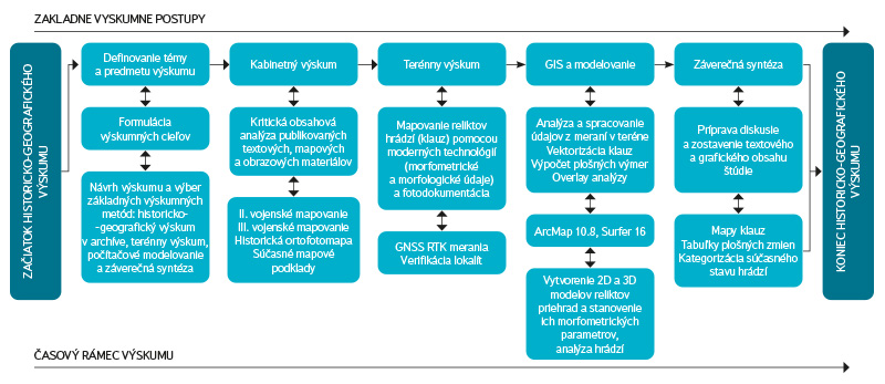
Fig. 1. Research workflow and data processing
BASIC GEOGRAPHICAL CHARACTERISTICS OF the STUDY AREA
The splash dams investigated in this study are located within the geomorphological unit of the Low Tatras, which represents an important mountain range in the central part of the Western Carpathians. The Low Tatras are the second highest massif of the Carpathian arc, with the main ridge predominantly oriented in a west–east direction. The highest point of the range is Mt Ďumbier (2,043 m a.s.l.). Most of the investigated splash dams fall within the catchment of the Váh river, while a smaller proportion lies within the Hron catchment [19]. The analysed features are located at elevations of approximately 800–1,250 m a.s.l. [20], predominantly in the upper parts of valleys, where they originated as storage reservoirs capturing the waters of mountain streams. Based on the interpretation of maps of the 2nd Military Mapping, a total of fourteen historical splash dams were identified in the area of the Low Tatras, forming part of a water management system designed for timber floating (Fig. 2, Tab. 1). From the perspective of administrative division, the studied mountain range is located within the districts of Ružomberok, Banská Bystrica, Liptovský Mikuláš, Brezno and Poprad. The area of the geomorphological unit of the Low Tatras was divided into two parts: northern and southern, with the boundary formed by the main ridge of the Low Tatras, which also represents the watershed divide between the Hron and Váh catchments.
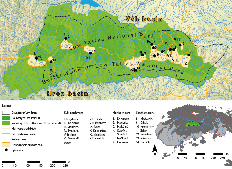
Fig. 2. Study area within the Low Tatras geomorphological unit, showing the location of identified splash dams on maps of the 2nd Military Mapping and verified in the field, with respect to sub-catchments
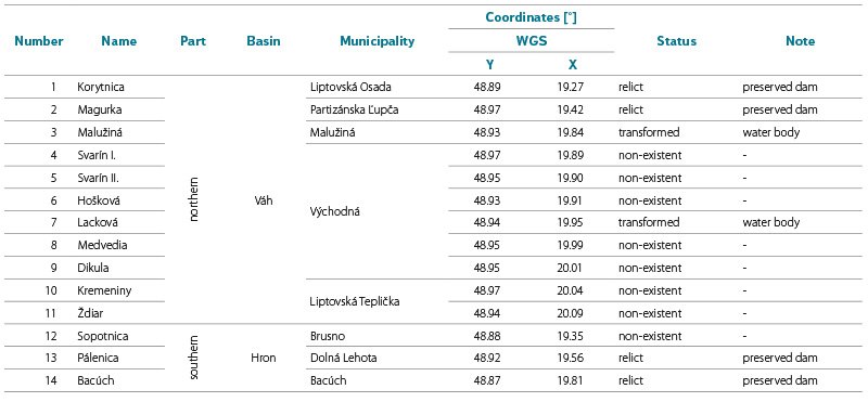
Tab. 1. Identified historical water reservoirs (splash dams) in the study area
Brief geological, geomorphological and soil characteristics
The main ridge of the Low Tatras is formed by a crystalline core composed predominantly of intrusive igneous rocks, especially granodiorites. The entire area belongs to the Central Western Carpathians, where Palaeozoic and Mesozoic complexes of the Low Tatras dominate. From the perspective of tectonic division, the mountain range is situated within two tectonic units: the Tatra–Fatra unit and the Vepor unit. The studied area belongs to the zone of core mountains of the eastern group with a Tatric crystalline basement. The crystalline complex of the Tatricum consists of acidic plutonic rocks (granitoids) and medium- to high-grade metamorphosed volcano-sedimentary complexes (gneisses, paragneisses, amphibolites and migmatites). Above this crystalline core lie original (autochthonous) sedimentary formations composed of a diverse group of rocks such as shales, quartzites, limestones and dolomites [21]. From a geomorphological perspective, the Low Tatras unit belongs to the Fatra–Tatra area of the Inner Western Carpathians.
The splash dams are located in the geomorphological sub-units Ďumbierske Tatry and Kráľovohoľské Tatry, more precisely in the areas of Prašivá, Salatíny, Priehyba and Ďumbier. The area is characterised by the relief of pedimented uplands and hilly landscapes, with a predominance of highland foothill relief. In terms of morphological-morphometric relief types, high mountains, moderately high mountains and hilly terrains prevail. The soil cover reflects both geological conditions and elevation. In both the northern and southern parts, rendzinas on carbonate substrates and podzolic cambisols on gneisses and granitoids with loamy-sandy to loamy textures dominate [20]. At the highest elevations and on slopes with higher moisture, modal and humic-iron podzols occur [22]. These geological and geomorphological conditions significantly influenced the location of splash dams, which were situated primarily in narrow valleys with suitable morphological conditions for dam construction.
Basic hydrological and climatic characteristics
The hydrological conditions of the area are determined by the mountainous character of the relief, with a predominance of short watercourses exhibiting pronounced seasonal discharge dynamics. Splash dams were constructed on smaller streams, where they enabled the regulation of flows and their short-term increase during periods of timber floating. The Low Tatras belong to two main second-order catchments; the Hron and the Váh. Within the Hron catchment, splash dams occur in the valleys of Vajsková (Pálenica), Sopotnica, and Bacúch, while those belonging to the Váh catchment are located in the northern valleys of Korytnica, Ľupčianka, Malužiná, Svarinka, Ipoltica, Medvedia, Dikula, Benkovo, and Ždiar. Splash dams in the Váh catchment belong to the sub-catchments of Revúca, Boca and Ipoltica, which are left-bank tributaries of the Čierny Váh. Splash dams in the Hron catchment are situated on its right-bank tributaries. From a hydrological perspective, the area represents a mid-mountain region with a snow–rain runoff regime characterised by pronounced seasonal variability (Tab. 2) [19, 23].
Tab. 2. Hydrological characteristics of the study area
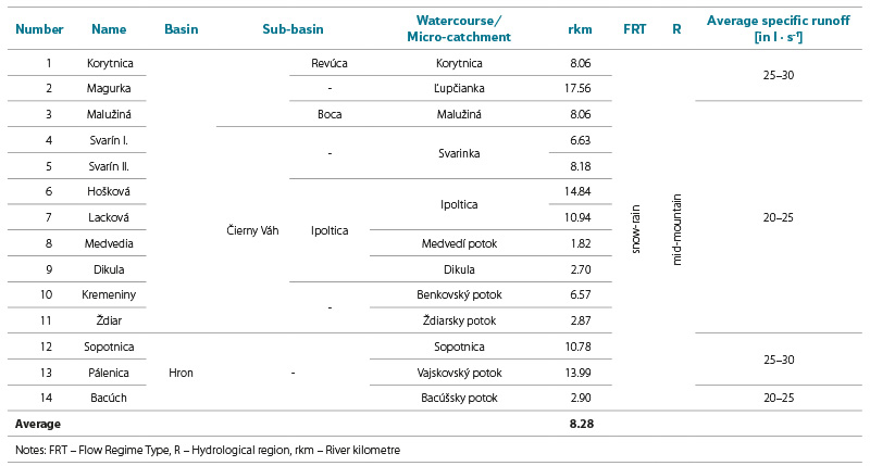
The average specific runoff ranges between 20–30 l ∙ s-1 ∙ km-2, with higher values typical of the northern part of the mountain range, where precipitation totals and snow accumulation are greater. Watercourses are short, steep and of a mountain character. The analysed splash dams are identified and located at river kilometres within the range of 1.8–17.6 km (with an average of 8.28 river km) (Tab. 3). At present, the hydrological regime of most of these watercourses remains natural, with only a small proportion of splash dams retaining their storage function [22].
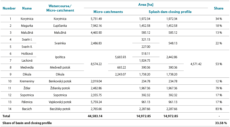
Tab. 3. Area of the micro-catchment and the closing profile above the splash dams
The Low Tatras are situated in a cold mountain and moderately cold very humid climatic region. The mean annual air temperature ranges from −1 to 7 °C. The average annual precipitation reaches up to 1,500 mm at the highest elevations and around 800 mm at lower elevations. The average number of days with snow cover ranges from 60 to 100 days [24].
Protected areas and ecological context
Several sites (13) are located within Low Tatras National Park or in its buffer zone (1) [25, 26]. This creates specific conditions for their potential restoration, where environmental and landscape-hydrological significance takes precedence over economic use. Today, these water bodies can function as habitat islands with high diversity of wetland vegetation, amphibians and insects, thereby representing valuable microclimatic and retention features in the mountain environment.
RESULTS
Identification of historical splash dams based on maps of the 2nd Military Mapping
Georeferencing of maps and the determination of the “precise” location of splash dam embankments in maps also enables accurate location of their relics in the field. Through the analysis of map sheets of the 2nd Military Mapping, 13 historical water reservoirs were identified in the studied area of the Low Tatras (a 14th splash dam, Kremeniny, was verified on the basis of written sources), situated predominantly in the upper parts of mountain valleys on smaller watercourses. Their spatial distribution shows a clear association with areas of intensive historical timber extraction and favourable geomorphological conditions for damming watercourses (Figs. 3, 4).
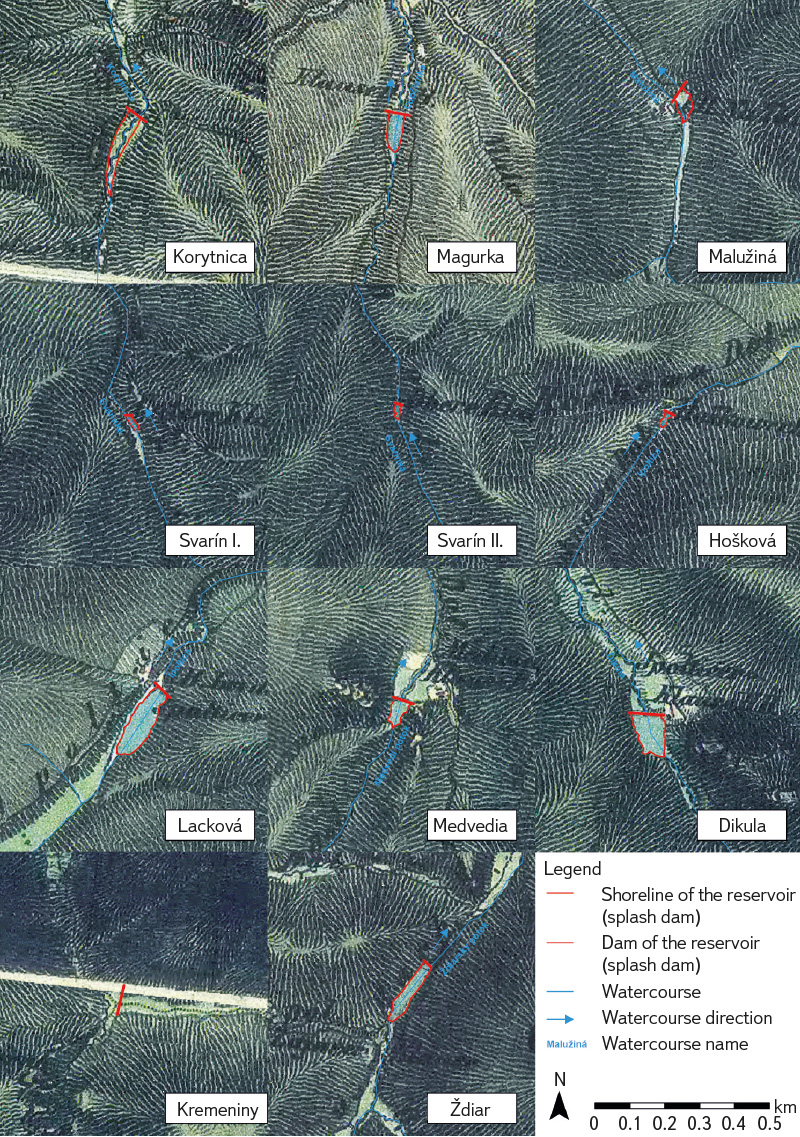
Fig. 3. Example of historical splash dams shown on the map of the 2nd Military Mapping in the Low Tatras region (northern part) (1 : 10,000)
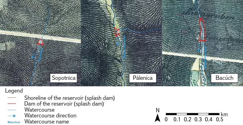
Fig. 4. Example of historical splash dams shown on the map of the 2nd Military Mapping in the Low Tatras region (southern part) (1 : 10,000)
The results of the processing of historical cartographic sources indicate that splash dams generally had a small to medium surface extent, with their size adapted to the short-term accumulation of water required for timber floating. Data on reservoir surface areas are, in many cases (given the absence of archival documents) the only available information, and can be verified only against data obtained from 3D modelling of disappeared splash dams. Input data for reconstructive 3D models can be obtained solely on the basis of field-based geodetic morphometric measurements (Tabs. 3, 4).
Most of the identified splash dam sites were depicted as individual water bodies with clearly distinguishable embankments. Thirteen splash dams were located in the upper reaches of individual valleys, as the accumulated water was used for timber floating from mountain areas to processing sites. In the Čierny Váh area, splash dams were also used to raise the water level of the river itself, along which semi-rafts were floated. Only the Bacúch splash dam was situated on the lower course, as it served exclusively to increase the water level of the Hron, enabling the floating of rafts even during dry summer months.
Comparison of the historical and current state of splash dams
The comparison of historical maps with current data from ZBGIS and the Orthophotomap of the Slovak Republic, together with their subsequent comprehensive comparison and verification using field research results, indicates significant changes in the morphological and morphometric extent of historical splash dams and their relics. In the first step, the main negative driving force responsible for their gradual disappearance was preliminarily identified. Where they were secondarily used as fishponds or for recreation, they have been preserved to the present day as water-filled relics. Where they were abandoned for economic reasons, they have gradually, under the influence of natural processes – particularly floods, weathering, water erosion, succession and sediment infilling – been preserved only in the form of larger or smaller relics, or have disappeared completely. Only in one case (the Korytnica splash dam) was destruction recorded as a result of anthropogenic driving forces (road construction).
According to their state of preservation, the individual splash dams were categorised (Tab. 4) as preserved (Malužiná, Lacková), partially preserved – relics (Korytnica, Magurka, Svarín I, Svarín II, Hošková, Medvedia, Dikula, Ždiar, Sopotnica, Pálenica, Bacúch), and disappeared (Kremeniny). The individual dams, or their relics, can also be classified according to construction technique into concrete–stone (Bacúch, Magurka), stone (Korytnica), stone–earth (Pálenica, Sopotnica, Medvedia, Dikula), embankment–earth, or rather stone–earth (Malužiná, Lacková, Hošková, Ždiar), and wooden (probably Svarín I, Svarín II and Kremeniny).
Out of the total of 14 identified historical water reservoirs, 8 sites (57.1 %) have disappeared and are preserved only in the form of relief relics, while a further 4 splash dams (28.6 %) have been preserved only as dam structures; only 2 splash dams (14.3 %) have been preserved as water bodies in a transformed form. Overall, 85.7 % of historical water reservoirs have lost their original storage function.
The comparison of the spatial extent of historical and present-day water reservoirs indicates a significant reduction in the storage capacity of splash dams. The current surface area represents only 34.9 % of the historical area recorded on maps of the 2nd Military Mapping and 19.2 % of the area recorded on maps of the 3rd Military Mapping, documenting a pronounced decline of these features in the landscape. The comparison of the historical and current state of selected splash dams illustrates different forms of their preservation within the landscape.
Characteristics of selected identified splash dam relics
Based on the comparison of the historical and present-day state, it can be stated that in the Low Tatras, lakes have been preserved at only two splash dam sites. These are the Malužiná and Lacková splash dams; however, both have significantly modified embankments and no longer serve their original purpose. They represent important ecological sites within Low Tatras National Park. The majority of splash dams (10) have been preserved to the present day in the form of complete or partial dam relics. Wetlands are often found in the area of the former reservoir basins. The only splash dam that could not be identified in the field was Kremeniny (or its relic) (see Tab. 1 for details).
Field verification of selected sites confirmed that the degree of preservation of historical splash dams varies considerably depending on their current use and the level of anthropogenic or natural disturbance.
With regard to the aim and scope of the study, a basic characterisation of two identified splash dams is presented. As representative examples, a partially preserved, still water-filled splash dam at Malužiná and the relic of a preserved dam at Magurka were selected, where a wetland is located within the former reservoir area.
The embankment of the Malužiná splash dam (Figs. 5–9) is located at river kilometre 8.06 of the Malužinský stream, in the headwaters of the valley of the same name on the northern slopes of the Low Tatras (cadastral area of Malužiná, Liptovský Mikuláš District). The Malužinský stream, which rises on the south-eastern slopes of Vrbovica (1,393.8 m a.s.l.) at an elevation of approximately 1,195 m a.s.l., is a fourth-order stream that flows into the Boca stream from the right at Malužiná at an elevation of approximately 738 m a.s.l. (the Boca stream flows from the left into the Váh river, which is a left-bank tributary of the Danube). The Malužinský stream has a snow–rain runoff regime and drains a catchment area of 4,465.9 ha.
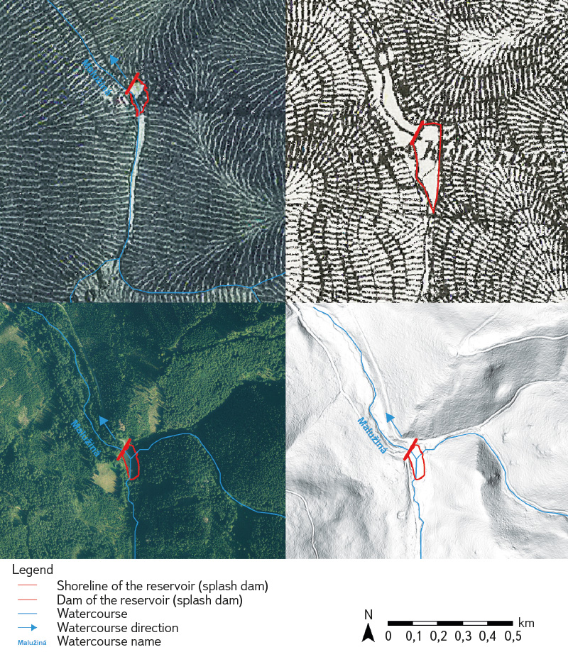
Fig. 5. Preserved water surface of the historical Malužiná splash dam in the northern Low Tatras (1 : 10,000)
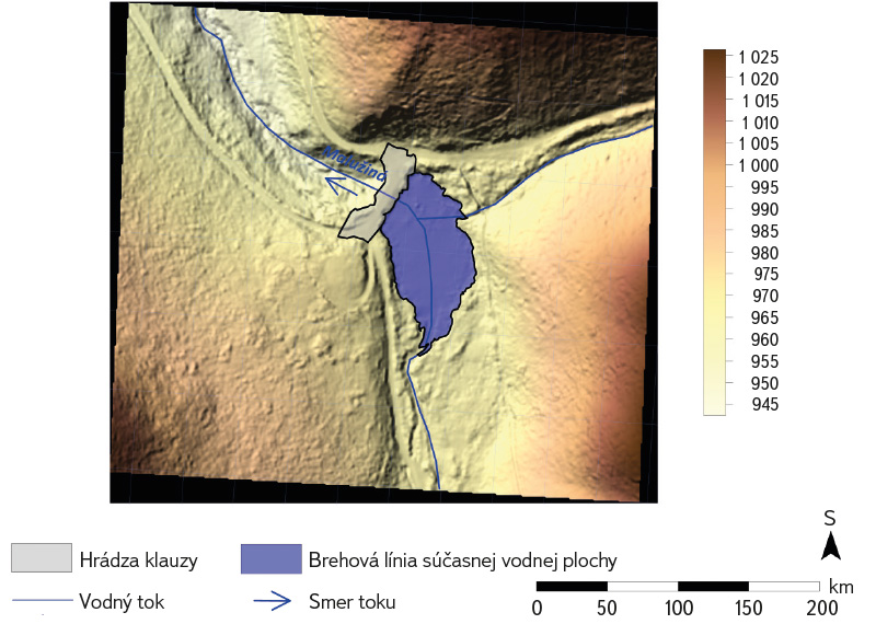
Fig. 6. Computer model of Malužiná splash dam based on field measurements
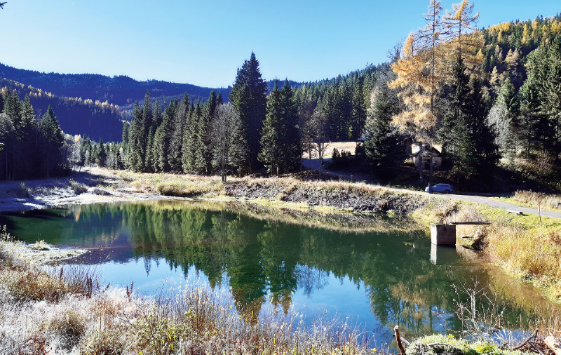
Fig. 7. Malužiná splash dam (right) and reservoir (view from the east), November 2025
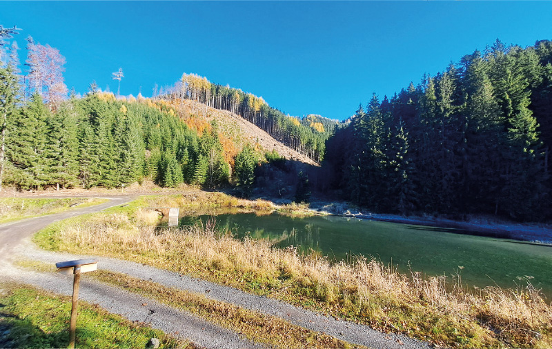
Fig. 8. Malužiná splash dam (left) and reservoir (view from the west), November 2025
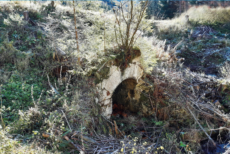
Fig. 9. Portal of a disused outlet gallery preserved in the embankment of Malužiná splash dam, November 2025
During fieldwork, the precise mathematical position of the geometric centre of the dam crest was determined at 48º 93′ N latitude and 19º 84′ E longitude. The elevation of the dam crest at the Pod Vrbicou site, located at the confluence of the Stratená stream (from the right) with the Malužinský stream, is 964 m a.s.l. The catchment area of the outlet profile of the splash dam, from which water was accumulated in the reservoir, is 585.12 ha, representing 13 % of the total catchment area of the Malužinský stream.
Based on additional field measurements and 3D modelling, the basic parameters of the relic of the original splash dam embankment are as follows. The width of the dam base is approximately 30 m, the maximum height reaches 8 m, and the crest length is 67.45 m. The volume of the reservoir could not be calculated due to its inundated state; its current surface area was estimated at approximately 0.25 ha, whereas according to the map of the 3rd Military Mapping, its area in the 1880s was 1.93 ha. The present surface area is determined by a temporary, rehabilitated spillway, as the original one is in a critical condition and non-functional. The original outlet adit, constructed in the centre of the earthfill dam from precisely worked travertine blocks and vaulted with a barrel vault, was approximately 22.5 m long (measurable part), 2.6 m wide and 2.5 m high.
At present, the surroundings of the splash dam are covered by spruce monoculture forests, although a large part has been subject to clear-cutting. On the left side of the splash dam, in a deforested area, there is a maintained hunting lodge, which is regularly rented out by Forests of the Slovak Republic to individual visitors for short-term stays for hunting, hiking, cycling or active recreation in the mountains. The site is accessible via an asphalt road (passable only with permission from the national park or state forests) leading through the Malužinská dolina from the village of Malužiná, which is approximately 8 km away. Two cycling routes run along this road. The first ends at the Pod Vrbicou site near the splash dam, while the second crosses the dam crest and continues further as a loop along forest roads back to Malužiná.
Given the absence of textual archival sources, historical maps (Fig. 5) represent the primary relevant source for reconstructing the history of the Malužiná splash dam. The earliest record, noted with a delay of more than 130 years in the chronicle of the village of Malužiná, states that the splash dam was constructed in 1801. It was a wooden log dam built of spruce timber, as also documented by sources held in the Forestry and Timber Museum in Zvolen. An already existing splash dam is depicted on a map stored in the Hungarian National Archives in Budapest (S 11 – No. 636) from 1804, where a blue-coloured reservoir with a dam is shown without a name. The map of the 2nd Military Mapping from 1839 depicts the splash dam reservoir in blue and labels the site as Na Teichu. On the map of the 3rd Military Mapping from 1876, the site is labelled as Klause and depicts a dam with a reservoir. It is highly probable that the original wooden dam was rebuilt and maintained several times until 1923, when it was reconstructed into an earthfill stone–earth dam, the relic of which is present in the landscape today. The maximum volume of the reservoir of the new splash dam, prior to sediment infilling, was 45,000 m³. The dam was constructed from material extracted in a quarry approximately 50 m in extent, opened directly near the dam crest on its right side. It ceased to serve its original purpose in 1930, when a forest railway was put into operation in the Malužinský stream valley.
The embankment of the Magurka splash dam (Figs. 10–14) is located at river kilometre 17.56 of the Ľupčianka stream, in the upper third of the valley of the same name (cadastral area of Partizánska Ľupča, Liptovský Mikuláš District), approximately 500 m south of the confluence of the Tlstý stream and Veľká Oružná with the Ľupčianka. It is situated about 500 m from the turn-off to the former mining settlement of Magurka, on the left-hand side of the road. The dam profile is positioned in a narrowed section of the valley between the ridges of Tajch on the right (eastern) side and Hlinisko on the left (western) side of the valley. The entire area is covered by spruce monoculture forests. The Ľupčianka is a third-order stream that rises in the Low Tatras (Ďumbierske Tatry), in the Ďurková massif (1,749.8 m a.s.l.), on the northern slopes below the Ďurková saddle at an elevation of approximately 1,605 m a.s.l. Originally, after 24 km it flowed into the Váh from the left near Bešeňová (at present into the Bešeňová reservoir) at an elevation of approximately 512 m a.s.l. The Ľupčianka has a snow–rain runoff regime and drains a catchment area of 7,942.16 ha.
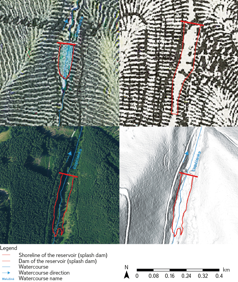
Fig. 10. Indications of the historical Magurka splash dam, still identifiable despite the disappearance of the reservoir (1 : 5,000)
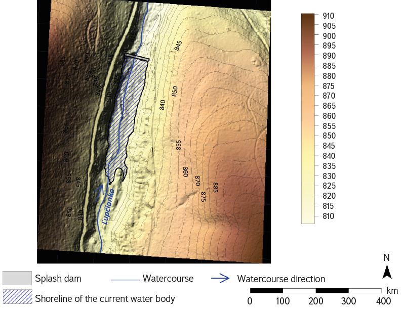
Fig. 11. Computer model of Magurka splash dam based on field measurements
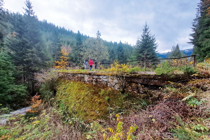
Fig. 12. Downstream slope of Magurka splash dam, November 2025
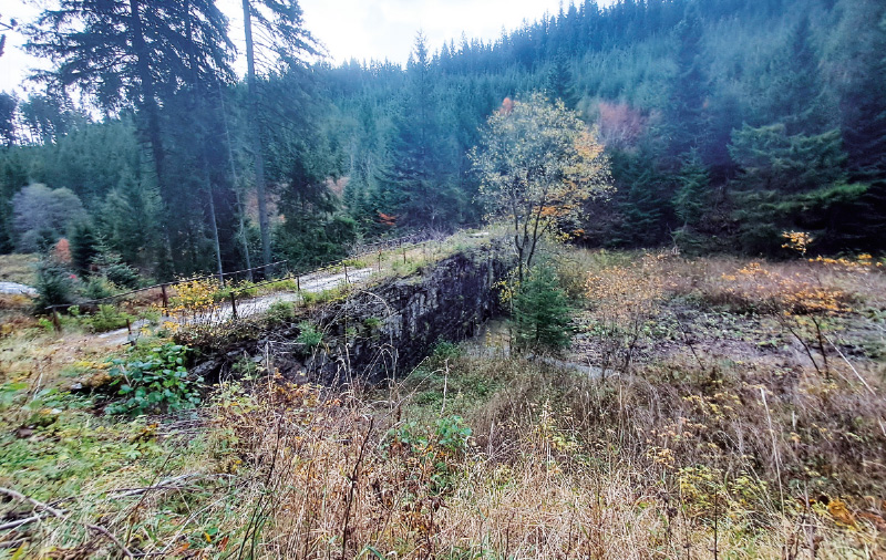
Fig. 13. Upstream slope of Magurka splash dam, November 2025
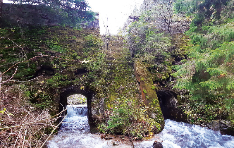
Fig. 14. Relics of outlet galleries of Magurka splash dam, November 2025
During field measurements, the precise mathematical position of the geometric centre of the dam crest of the Magurka splash dam was determined at 48º 97′ N latitude and 19º 42′ E longitude. The elevation of the crest is 817.5 m a.s.l. The catchment area of the outlet profile of the splash dam, from which water was accumulated in the reservoir, is 1,452.58 ha, representing 18 % of the total catchment area of the Ľupčianka stream.
Based on field measurements and 3D modelling, the basic parameters of the relic of the dam and the original splash dam are as follows. The width of the dam base is 11.27 m, the height 9.9 m, and the length 54.3562 m. The volume of the reservoir was 38,833.3 m³ and its surface area 10,743 m². According to the map of the 2nd Military Mapping from the mid-19th century, its area was 0.72 ha, and according to the map of the 3rd Military Mapping from the 1880s, 1.87 ha. The dam wall is constructed of quarry stone, with the crest reinforced by a concrete slab. In its lower central part, the dam contains two outlet openings vaulted with segmental arches, while in the central upper part there is a spillway. To prevent back erosion below the outlet openings, the stream bed is lined with wooden beams and its banks are reinforced with retaining walls over a length of approximately 30 m. In the centre of the dam, there was a wooden shelter housing the technical equipment used for opening the outlet gates.
Just like in the previous splash dam, the main historical sources for the study of the Magurka splash dam are historical maps. Written sources document the construction of a wooden–earth dam as late as 1819, intended for the annual floating of timber to Partizánska Ľupča. Relics have been preserved approximately 5 m below the existing stone dam on both sides of the wooden chute. The original log structure had a base thickness of approximately 20 m, a length of about 45 m, and its height can be estimated at around 8 m. This reservoir is first depicted on the analysed maps of the 2nd Military Mapping from 1845, where it is shown as a blue-coloured lake and labelled Klause. On the map of the 3rd Military Mapping from 1876, the site is depicted and labelled Klause, and the site in which it is situated is named Na Teichu. The splash dam was maintained and probably served its purpose until the beginning of the 20th century, as in 1911 the Forest Cooperative in Nemecká (now Partizánska) Ľupča constructed the present dam. By 1938, historical maps already depict the site without a reservoir and refer to it using Tajch Slovak nomenclature. That the splash dam was most likely no longer in operation at the turn of the 1930s and 1940s is also evidenced by a record in the municipal chronicle of Partizánska Ľupča, which states that timber from the Teich was already being transported by horse-drawn wagons. On maps produced after 1955, only the dam is shown, without a reservoir.
DISCUSSION
Based on the content analysis of historical maps, with particular emphasis on the 2nd Military Mapping from the second half of the 19th century, and on archival sources, a total of 14 splash dams were identified in the area of the Low Tatras, in most cases preserved only as dam relics. However, it is highly probable that in the past (since the 16th century), additional small water reservoirs were constructed in the headwaters of Low Tatras streams, which had already disappeared by the mid-19th century. This assumption is suggested by limited textual archival sources; however, these wooden, partly earth-built dams are now in such an advanced stage of naturalisation that their location in the field will most likely be impossible. The confirmation or refutation of these hypotheses will require more detailed historical-geographical research (partly making use of the methodology presented here).
According to the state of preservation of splash dams in the Low Tatras, or their embankments, the individual sites were classified (Tab. 4) as preserved, partially preserved – relics, and disappeared. In the studied area, preserved dam structures clearly dominate, not only as compact bodies but above all as remnants of specific forms of anthropogenic water-management relief. From the results of the research on splash dams in the Low Tatras, as well as on the basis of a preliminary survey of their location and condition in other mountain ranges of the Western Carpathians, it can be inferred that, upon completion of the overall research, a fourth category will likely be added, namely restored reservoirs in the profiles of former splash dams. These have been referred to in previous sections of the study.
Tab. 4. Parameters of the study splash dams
Preserved splash dams (i.e. water-filled reservoirs with reconstructed embankments) represent a minor proportion of the analysed set, and their current function generally differs from their original purpose. In several cases, these features have been adapted to new uses, particularly as small retention reservoirs, fishponds, and water features for recreation. The results indicate a significant reduction in the spatial extent of historical water reservoirs, confirming a long-term trend of the disappearance of technical features associated with historical forest management.
Historical splash dams in the area of the Low Tatras underwent rapid degradation following the loss of their original function. In contrast to fishponds, which were often used continuously or adapted to new economic purposes, splash dams represented purpose-built and temporally limited hydraulic structures whose existence was closely tied to timber floating. After the cessation of this activity, they lost their practical significance, which led to their neglect and subsequent disappearance. A similar trend of splash dam decline has also been recorded in other areas of the Western Carpathians, where these features were associated with historical forest management. Their importance is currently increasing again in connection with climate change, which is manifested by a more frequent occurrence of extreme events – droughts, torrential rainfall and soil erosion. Their study is thus becoming not only a specialised historical-geographical topic, but increasingly also raises the possibility of their reconstruction within the landscape of Low Tatras National Park. Such efforts need not necessarily involve only the reconstruction of reservoirs but may also include the restoration of wetlands as unique habitats. At present, Forests of the Slovak Republic are considering the possibilities of restoring the Malužiná and Bacúch splash dams in the Low Tatras, as well as other splash dams in different mountain ranges.
As the main aim of the paper was to identify historical splash dams (and subsequently analyse their spatial extent) on the basis of historical maps, with particular emphasis on maps of the 2nd Military Mapping, it is also necessary to point out the limitations of these cartographic sources, which, however, can be reliably minimised through appropriate methodological procedures, experience and expertise. When interpreting historical maps, it is essential to take into account possible positional inaccuracies, which in the case of the 2nd Military Mapping may reach approximately 20 to 50 metres after georeferencing. In mountainous areas, particularly in valley headwaters, these inaccuracies tend to approach the upper limit. These inaccuracies, however, do not affect the identification of the existence of splash dams, as their location can be refined on the basis of the relief framework and the course of watercourses through comparison with current maps. A greater challenge arises in the precise geometric delineation of these features and in determining their morphometric characteristics. In some cases, it may be difficult to distinguish splash dams from other types of small water bodies, or, due to their small size, to identify them at all. These limitations were minimised through content analysis of additional cartographic (and textual) sources, mutual comparison of all available historical and contemporary materials, and detailed field verification. Maps of the 2nd Military Mapping provide sufficient thematic content and relatively good positional accuracy for the identification of historical water bodies and technical structures. For the purposes of this research, their primary value lay in their ability to reliably capture the existence and spatial distribution of splash dams, rather than their precise geometric parameters. The obtained surface areas, shape characteristics of the reservoirs and other morphometric parameters are therefore considered only supplementary, unless verified by other sources.
From all materials obtained through desk-based or field research, it is possible to derive new, far broader, higher-quality, more accurate and more comprehensive information by applying modern computational methods, digitisation, computer modelling and GIS. Within a computational environment, it is possible not only to create reconstructive 2D and 3D models, but also to obtain qualitatively new insights into disappeared splash dams that are not contained in any existing sources.
The results of our research show that as many as 85.7 % of splash dams in the area of the Low Tatras have disappeared or have been preserved only in the form of relics, while the current surface area of water reservoirs represents less than one fifth of the historical extent recorded at the end of the 19th century.
Our research also highlights the importance of historical cartographic sources as an irreplaceable source of information on disappeared landscape features. At the same time, it points to the potential of historical splash dams in current discussions on water retention in the landscape and sustainable water resource management in mountain areas.
CONCLUSION
The paper focused on the identification and analysis of the spatial development of historical water reservoirs (splash dams) in the area of the Low Tatras, based on a comparison of maps of the 2nd Military Mapping with current cartographic sources. The results indicate a significant decline in historical splash dams, with only a small proportion of these features preserved to the present day as water bodies or terrain relics.
The analysis confirmed that splash dams represented short-term, purpose-built hydraulic structures, the disappearance of which was closely linked to the cessation of timber floating. Most historical splash dams disappeared as a result of natural geomorphological processes and changes in land use. The proposed typology of splash dam preservation enables a systematic assessment of their current condition and provides a basis for further research into these anthropogenic relief features.
The marked decline of historical splash dams can also be interpreted in the context of the geomorphological and hydrological conditions of mountain environments. Steep slopes, high stream energy and intense erosion processes accelerated the infilling of reservoirs with sediments and the degradation of dam structures. Simultaneously, vegetation succession gradually eliminated the visible manifestations of these features in the landscape.
From the perspective of historical geography and landscape research, splash dams represent an important record of human technical adaptation to the mountain environment. Their spatial distribution reflects historical economic strategies and the ways in which natural resources were utilised in the Carpathians. In comparison with other regions of the Western Carpathians, it can be stated that the disappearance of splash dams is a general phenomenon, with local differences determined primarily by the degree of subsequent land use and interventions in the hydrological regime.
Acknowledgements
The research was carried out within the project KEGA No. 008UMB-4/2025 Lifelong learning of pedagogics and scientific researchers of natural sciences at universities in geographic information systems and within the project Historical log-driving dams of the Western Carpathians: geodetic documentation, GIS analyses and 3D reconstruction of dam structures.
The Slovak version of this article was peer-reviewed, the English version was translated from the Slovak original by Environmental Translation Ltd.
