
Have you ever wondered what a hydrologist might discuss at a table with historians, archivists, and chroniclers? Can historical data help us gain a better understanding of today’s flood risk assessment? And might deeper knowledge of past floods prepare us for future ones linked to climate change? We put these questions to Ing. Libor Elleder, Ph.D., in the October hydrology issue of VTEI.
Dr Elleder, in your view, what is the significance of historical sources such as chronicles, old maps, and municipal records for hydrology today?
To put it simply, all these historical sources significantly expand our knowledge of extreme events such as floods, droughts, heavy rainfall, but also harsh winters, tornadoes, or crop failures, reaching far back into the past, beyond the reach of any instrumental records based on measurements of temperature, precipitation, or water levels. It is not just about the intensity or magnitude of floods, but also their typical seasonality, which can change gradually over time due to climatic conditions. These are just a few examples. Should we simply give up on such information? That might be the defence of historical sources. But why are such sources not generally accepted in hydrology? An impartial judge might raise that question. Were the prosecution to speak, we would probably hear about the vagueness, inaccuracy, unreliability, and “gaps” in historical sources. The devil’s advocate would add that chroniclers often embellished their accounts, lacked impartiality, flood markers were moved, watercourses altered, natural conditions changed, and everything is simply different now, so such sources are useless. A member of the jury might also add that they had never even heard of anything like historical sources and that it is better to stick to “traditional” methods. The usefulness of these sources therefore needs to be carefully explained and patiently defended. It seems, however, that it is not only chronicles that are at risk of being forgotten, but also the records and documents created and preserved by generations of water management professionals fifty or a hundred years ago. The political upheavals of the twentieth century, combined with generational forgetfulness, have also deprived us of many more recent, equally irreplaceable sources.
Zlata Šámalová from the Elbe Basin State Administration recently recalled how, decades ago, water management archives were being destroyed, piled onto a large heap. At the last moment, however, it was possible to rescue some bridge projects, river engineering plans, and riverside maps, preserving them for the future. From the archives of the Sewerage Commission, most of the glass negatives documenting water management structures from the early twentieth century were reportedly sent to glassworks for melting. Even so, many were saved, including an entire truckload of these glass negatives. After all, water management and hydrology archives and documents form part of historical hydrology. It has been more than half a century, but it is important to mention.
Do you ever encounter doubts about the reliability of such sources?
In the nearly forty years I have worked in hydrology, I have met many colleagues who were somewhat sceptical about combining hydrology with history or other humanities disciplines; however, the reverse is also true. Others were enthusiastic. It depends on one’s character, personal experience, and upbringing. My parents had a humanities education: my mother studied at the Faculty of Arts and worked at the Technical Museum in Prague, while my father was a lawyer whose favourite hobby was history. So our home library was full of books on history and art, and, alongside politics, these were frequent topics of discussion. When I visited my mother at the Technical Museum, I felt very comfortable, or even great, among the old machines, drawings, and maps. One more explanatory note: my strong appreciation for visual art. Old maps, manuscripts, and books are stunningly beautiful, there is no question about that. What I want to emphasise is that historical sources never repelled me; quite the opposite.
The question, however, is how all these sources can actually be used, say, in hydrology. My grandfather came from the ancient Ille milling family in South Bohemia. At his family mill in Kostelní Radouň, there were two beautifully marked flood gauges from the flash floods of 1934 and 1949. I assumed that, just as there were floodmarks at our family mill, similar floodmarks could be found at other mills. Later, I realised that this was not quite the case. In theory, such data harbour vast informational potential. For me, they were a powerful initial source of inspiration.
The database of Czech watermills compiled by Rudolf Šimek now contains 11,904 mills. That is a substantial number, and if flood records had survived, they would be an invaluable resource – especially for smaller catchments, where no systematic records exist. Each mill would have had a flood gauge and some form of water-level measurement. It is almost certain that, at one time, most mills had at least some flood marks. However, a field survey in 2007 revealed that in most cases these marks were in a very poor state, even at sites where they had still been visible around 1930. The authors of longitudinal profiles at the Hydrological Institute recorded a number of such water levels in the Vltava, Sázava, Jizera, and Berounka rivers between 1920 and 1950. One can see that, on the Vltava before the cascade dams were built, profiles with one or more flood marks existed at almost every, or at least every second, river kilometre.
How can chronicles and municipal records be utilised?
A similar situation applies to chronicles and municipal records. Today, there are over 6,200 municipalities in the Czech Republic, many of which disappeared after the war, so the actual number was even higher. Again, this represents an enormous amount of potential data on weather and floods. Working with them does not always lead automatically to success; however, when we were analysing the floods of Rakovnický stream, a case occurred of two alternative dates for a flood on the Rakovnický and Lišanský streams. I then found an explanation in the chronicle of the village of Hředle. In May and June 1852, the village was struck by a total of five flash floods within a period of about three weeks. Both alternatives were confirmed, and moreover we obtained information on a longer period during which flash floods affected a broader area. The use of a large number of municipal chronicles also showed that May floods in the Rakovník, Podbořany, and Beroun regions are by no means exceptional, but rather something typical. The great flood of 25 May 1872 fits into the context of this area quite well. From 1836, all market towns were required to keep chronicles, and a hundred years later, this applied to all municipalities. It seems that these records of floods, droughts, and storms in local chronicles have largely been left unused.
And how far into the past can one look by means of these sources?
Going further back, written sources related to the history of royal or dependent towns can be consulted, with records beginning in the fifteenth or sixteenth century. In Prague, evidence of floods starts with Kosmas’s chronicle; the earliest flood mentioned here occurred in September 1118.
Our oldest riverside maps date from the reign of Maria Theresa and her sons Joseph II and Leopold II, mainly from the period 1770 to 1795. The oldest map of the Otava showing water depths in cross-sections is from 1794, while the earliest such map of the Vltava is from around 1822 to 1825. What use are these materials? They are the only records we have of natural or human-induced changes in our rivers. They provide answers to questions such as the causes behind the separation of certain river meanders or the changes in the cross-profiles of the Vltava and the Elbe.
From 10 to 12 September 2025, the third international workshop of the Flood Working Group (FWG) of PAGES (Past Global Changes) was held in Prague. The group aims to create a global database of flood event records. It was established in 2016 at the first workshop held at the University of Grenoble. Efforts to combine methods of historical hydrology with the results of paleoflood hydrology are still developing. We were pleased that this year Czechia was represented by a key speaker, Associate Professor Jan Hradecký from the University of Ostrava, an expert in river morphology and the documentation of contemporary and past landslides. Thanks to the archaeologist Jan Havrda, we were also able to show some dated fluvial layers in Prague, even from the 14th century, when the frequency of major floods was exceptionally high according to documentary sources. A great support and model in this regard are experts from the USA, the United Kingdom, Switzerland, Spain, Germany, the Netherlands, and Israel.
Can you give a specific example where historical sources have yielded something interesting, new, or exceptionally useful?
Recently, a 1714 map of the Brandýs and Nymburk manorial estates was discovered in a Viennese archive, showing the actual confluence of the Elbe and Jizera rivers up to Stará Boleslav. It includes mill race channels, vanished fishponds, and other features. In the 1844 riverside maps of the Elbe, water depths, shallows, and stones, removed from the riverbed in the nineteenth century, are recorded.
In the 1990s in our archive in Brozany, we discovered the oldest series of daily records from Magdeburg, beginning in 1727. It is possibly the longest series of daily water levels in Europe, or even in the world. For a long time, no one knew about it. Around 1880, Professor A. R. Harlacher, head of the Hydrometric Section of the Hydrographic Commission of the Kingdom of Bohemia, had it sent to him by colleagues in Magdeburg, as he was interested in the declining trends of minimum water levels in this old record. Had the package of extracts been lost, no one would have noticed or missed it. However, as we have it, it is much better. Many similar series are considered lost, at least for the time being. This example gives hope that many more may still be found in various uncatalogued collections – perhaps in places we would not expect. My colleague Jan Řičica copied the package and sent it back to German colleagues in Magdeburg, returning it after 110 years. We divided the work of transcribing the series between the Czech Hydrometeorological Institute (CHMI) and TGM WRI equally with Ladislav Kašpárek; he did not need convincing that it was a good idea. Today, colleagues from the German research institute Bundesanstalt für Gewässerkunde (BfG) have already published two studies on changes in the Magdeburg gauge profile, including a quantification of this unique flow series.
And what do these discoveries tell us about the actual development of water management?
It is not only about floods. It is quite logical, and probably even necessary, to attempt to understand the development of water management as a discipline. Only with the insights gained from the commission inspections of the Elbe from Mělník to Cuxhaven did new information clearly emerge, for example regarding the significance of “hunger stones” and the markings on them. Their importance was clear to the commissioners at the time. When studying floods and droughts, we also need to consider the historical development of settlement along the rivers. Twenty years ago, under the leadership of Rudolf Brázdil, the book Historical and Recent Floods was published. Since then, we have gathered a wealth of information on both floods and the development of Prague and other settlements. This allows us to answer questions such as whether floods similar to those of 1997 or 2002 occurred in the past, with far greater certainty than before. In our country, we are fortunate to have relatively long, systematically measured series of water levels and precipitation, largely thanks to the foresight and expertise of Professors A. R. Harlacher and F. J. Studnička. However, if we look at the history of floods on major rivers such as the Sázava, Ohře, Jihlava, Dyje, and even the Jizera, we see that the recorded series only begin after the era of major floods in 1784, 1845, and 1862. Without this insight, we would probably obtain a rather distorted picture of major floods in these and other catchments. And this is just one example.
Could you give a specific example of when historical records have helped to better understand or refine flood risk assessment?
Perhaps the question could be framed the other way around: when has the absence of historical data led to mistakes and worsened disasters? Such examples are often cited in lectures by key speakers, for instance Victor Baker from the University of Arizona, or arguably Spain’s leading expert in paleoflood hydrology, Gerard Benito. I will give just two examples, both connected to the year 2011. Coincidentally, both involved nuclear power stations threatened by water. In March of that year, it was Japan’s Fukushima Daiichi, endangered by an earthquake and the resulting tsunami. In June, the Fort Calhoun plant on the Missouri River faced serious flooding. In both cases, historical data are available; it is just not very clear why they were not properly used in the design of the structures. Although the US power station was inundated, the event passed without major consequences; however, five years later the plant was decommissioned and gradually dismantled. In Japan, the outcome was much worse, as is widely known.
How did the scientific community view the use of historical records in the past?
Professor Nobuo Shuto of Tohoku University has studied tsunamis, both through modelling and historical cases. As he recalled, a key event for him was the great tsunami of 1983. Eyewitnesses during his field research told him that, while it was terrible, it was nothing compared to the tsunami of 1896. He then began studying historical cases; however, by that time, the Fukushima Daiichi plant had already been built.
It is quite interesting that it was precisely in the 1980s that there was a general return to the use of historical data. Even then, a number of papers appeared, including the 1982 Science article Palaeoflood Hydrology by V. R. Baker. The theoretical basis for incorporating unsystematic data into statistical analyses came with formulas published in 1987 by J. R. Stedinger and T. A. Cohn, which allow datasets above a chosen threshold (including pre-instrumental data) to be combined with annual maximum series. At the same time, Vít Klemeš published several articles criticising the derivation of flood recurrence intervals from very short records. Klemeš emigrated to Canada in 1968, where he became a recognised hydrologist. I remember lectures by V. R. Baker, who particularly highlighted Klemeš and endorsed his ideas. When Ladislav Kašpárek and I were preparing for this year’s lecture on 18 March, marking the release of the book Historical Floods on the Rakovnický Stream, he recalled that in the 1980s, these very Klemeš articles were the ones he read and knew well.
I was not present when Ladislav Kašpárek discovered, during fieldwork after the July 1981 flood, a flood mark from 1872 on the rock above Červený Stream. He recalled this repeatedly, most recently during the aforementioned lecture this year. In 1984, he published a paper explicitly addressing the influence of incorporating historical data into statistical analyses. Today, the peak values of the Litavka and Berounka rivers in 1872 are taken for granted. However, this was by no means obvious: the reconstruction of the flood on the Litavka was somewhat daring, and publishing the results was bold.
Can we find other personalities who similarly emphasized the importance of historical floods?
There is a certain parallel here with the Japanese Professor Shuto and his field survey after the 1983 tsunami, which set him on the path toward studying historical events. Since 1978, historian and archivist Jiří Kynčil had been working on excerpts concerning historical floods in the Ore Mountains and the Ohře River Basin. He carried out this work for the state enterprise Povodí Ohře. At the time, the focus was on coal mining in the region and the future protection of surface mines. It was necessary to gather as much information as possible on floods in the short Ore Mountain tributaries of the Bílina and Ohře rivers. Less well known is a shorter publication on the Jílovský Stream. As early as 1983, Jiří Kynčil noted that estimates of flood recurrence intervals for the Jílovský Stream were probably underestimated. It is interesting to read, in the reflections of a person with a humanities background, the same objections regarding the insufficiency of thirty- or fifty-year records for deriving a 100-year flow as those raised by world-leading hydrologist Vít Klemeš; the documented floods from 1897 and 1927 had not been used. Shortly afterwards, an actual extreme flood occurred on the Jílovský Stream, which Ladislav Kašpárek then analysed. This is how the two of them became connected through the Jílovský Stream. Jiří Kynčil later inspired Oldřich Kotyza, an archaeologist from Litoměřice, to explore the topic of historical floods – a subject Kotyza dedicated his entire life to, alongside climate history. Ladislav Kašpárek believed that estimates of extreme flows were crucial. In addition to his estimates for the Litavka flood of 1872, he provided estimates for the Střela, Blšanka, Berounka, Vltava, and finally the Rakovnický Stream. In doing so, he made a substantial contribution to our understanding of potential flood risk.
How do you verify and interpret historical data, which often appear not as precise figures but as descriptions or narratives?
There are several considerations. We consider contemporary accounts (primary rather than secondary sources) to be the most reliable. We also give preference to quantitative data, which usually concern historical peak water levels. Typically, these are flood marks, so-called epigraphic sources. Equally precise can be flood heights derived from chronicle entries linked to fixed reference points. The best-known example is the Gothic sculpture of “Bradáč” (Bearded Man) in Prague. We surveyed it in 2004, which resolved doubts about the circumstances of its relocation to a new position in 1848. In this way, we now have a series of quite precise peak water levels in Prague dating back to 1481.
It could also be the floor level of a church. However, there can always be obstacles and uncertainties about past changes in the position of such a site or structure. A sad example is the Church of St. Anne in Hradec Králové, which was demolished during the construction of fortifications around 1775. A building plan of the church survives, but without elevations. In the sixteenth and seventeenth centuries, flood heights on the Elbe were repeatedly referenced to the floor level of this church. This allows us to know the relative levels of these peaks quite precisely. Yet linking this series to other extreme floods such as the devastating flood of 1775 or probably the worst floods in 1804 and 1846 remains a problem. I remember being shown around Hradec Králové by the aforementioned Zlata Šámalová, who sadly pointed out the area around the roundabout, where perhaps some tiny remnants of the church still lie buried underground.
What should be done in cases where only imprecise or qualitative descriptions of floods are available?
There are many floods where the determination of peak water levels is somewhat “fuzzy” or where we only have records of significant property damage, giving us a “qualitative” description, such as damage to crops, objects being swept away, houses damaged, or bridges destroyed. A 1-to-3 point scale is used here, with an approximate relation to N-year return periods provided as a guide. Clearly, if people are taking refuge on rooftops, and houses and bridges are collapsing, it is not going to be a 5-year flood, or even a 20-year one. In such cases, we either settle for an estimate or rely on a better-documented situation further downstream, where quantitative data can serve as a reference. It is important to emphasise that historical hydrology is not just the collection of flood data. One must also understand the development of a given locality over time, including any changes in the floodplain and the river channel. This can sometimes be quite challenging.
 A photo of Bearded man (or in Czech “Bradáč”) from a 2004 survey shows that his head is, in contrast with mine, 70 cm tall
Can you provide a specific example where knowledge of the development of a locality helped to correctly interpret a flood?
One of the best examples is Prague. Here, since the construction of weirs (roughly from the thirteenth and fourteenth centuries) the riverbed did not deepen, in contrast with, for instance, in Cologne, Germany. Here, the Rhine gradually deepened its channel, influenced in part by various human interventions. Evidence of this was left in the form of drawings of German towns during his voyage along the Rhine, Main, and Danube in 1636 by the Czech etcher Václav Hollar. Weirs extending across the entire river were by no means common on larger rivers in the Middle Ages and often are not today. Mills managed without them, and on the Rhine, boat mills were more typical; constructing a stone bridge across a river was generally feasible only on smaller streams in the medieval period. The Vltava in Prague, the Elbe in Dresden, and the upper Danube in Regensburg remained, for a long time (roughly until the nineteenth century) at the limits of technical possibility. On the Rhine, floating bridges were often used, for example in Mannheim. The situation in Prague is actually quite unique; riverbed changes were slowed by the system of weirs, and alterations in terrain heights were halted by the gradual paving of the city, a process that began in the thirteenth and fourteenth century. This knowledge allows us to interpret reports of major floods, such as those occurring during the construction of Charles Bridge. At that time, Prague experienced a series of floods in 1359, 1367, 1370, and 1374, for which we can estimate peak levels approximately, based on the horizontal extent reaching churches such as St. Michael, St. Giles, or St. Linhart. This is why it is important to study in detail how the Old Town of Prague was inundated in the nineteenth century, when peak water levels are already known with high precision. Such knowledge is invaluable. It allows us to better understand what two prominent chroniclers of the time of Charles IV meant in their brief descriptions of the water reaching the Old Town. Put in modern terms, they recorded that Prague experienced roughly four “50 to 100-year floods” over a fifteen-year period beginning in 1359.
How can the reliability of historical descriptions of extreme floods be verified?
When, as part of a research project on changes in floodplains in 2007, we surveyed the floodmarks along the Sázava River, we came across reports of a flood in Ledeč nad Sázavou that had reached some two to three metres above the Q100 level. This might be dismissed as an unreliable record. Yet similar descriptions of flood heights were found in every surrounding town, from Žďár nad Sázavou to Kácov. These data were consistent with the descriptions of the number of drowned persons in the respective municipal and parish registers – in total, 240 people drowned. The flood in question occurred on 31 July 1714. I mention this case because we attempted to reconstruct a plausible rainfall scenario that could have produced a hydrological response corresponding to at least one chronicle description. The rise and fall of the Sázava River was in detail described by the dean of the church in Německý Brod town (today Havlíčkův Brod). The required rainfall and its intensity ultimately still “fit” under the envelope curve of maximum precipitation for our country. It worked!
HEX Conference, Bonn 2014. Participants in front of the Main Gate of the town of Eibelstadt, with about 20 to 30 flood marks from 1550 to 2002.
In what way are historical floods systematically made accessible today?
In recent years, we have been working to bring together information on selected extremes into the MEF mapping application. MEF is built on ArcGIS. Its purpose is straightforward: to present historical floods in their full spatial extent. Major regional summer floods cover hundreds of thousands of square kilometres, while great winter floods – such as those in February 1374 and 1784 – affected an extraordinary area stretching from France to Bohemia, possibly even beyond. Processing such events can be time-consuming, but the reward lies in being able to view each episode as a whole and compare it with other historical situations. The key motivation here is precisely the verification of data within the overall context. An example is the February 1374 flood; on Czech territory, we have only two mentions – from Prague and the Ohře Basin – yet these are confirmed by dozens of descriptions across Central and Western Europe. The credibility of later chronicle records, where more detailed notes survive, is reinforced by matching evidence: for instance, the travel times of flood waves in 1675, 1784, 1824 or 1890 between towns such as České Budějovice, Prague, Dresden and Magdeburg, or the mutually consistent descriptions of damage and peak water levels.
When researching historical events, do you collaborate with historians, archivists or other experts outside the natural sciences?
Over time, I found several colleagues who were either interested in the subject or at least willing to engage with it – sometimes both. Perhaps the best example was the archaeologist Oldřich Kotyza. When, in 1995, he published his booklet Historic Floods on the Lower Elbe and the Vltava on the occasion of the anniversary conference of the 1845 flood, I was thrilled. That was hydrology in practice! In 2003, we met the renowned Prague archaeologist Ladislav Hrdlička at the conference City and Water. He helped us a lot with understanding the development of Prague’s terrain. He also introduced me to his colleague Zvonimír Dragoun, a surveyor who worked in nature conservation, heritage preservation, and archaeology. Today I can hardly imagine my work without him. In Prague, the archaeologist who now comes closest to the issues of fluvial sediments and their dating is Jan Havrda. Over the past thirty years, Prague archaeology has made great progress, particularly in interpreting changes in floodplain areas that are of such interest to us – for example, the development of Malá Strana, Kampa, and Klárov, the evidence of terrain changes around the Klementinum, or the position of the old wooden bridge that was deeply submerged during the flood of 1118.
Photograph with a floodmark on a monastery in Plasy showing that in 1872 I would have had no chance at this spot.
We have received help from staff at Prague Museum and from many other museums and archives – in total, dozens of people. Our most substantial joint work, however, has been with the historian Jan Lhoták, a specialist on the history of the Šumava region and the town of Sušice. In 2013 we published together an extensive collection on the floods of the Otava River from 1432 to 1900. We had hoped that a follow-up in book form would also find support, but to our surprise there was no interest. I believe that interdisciplinary collaboration is far more natural in Western Europe, though it is gradually gaining ground here as well. If I were to name people internationally who study the history of floods, I must mention the historian Andrea Kiss, who works at the Technische Universität (TU) Wien alongside the hydrologist Professor Günter Blöschl. Within the community of scholars dedicated to historical floods in Europe, one finds archaeologists, historians, geographers, and geologists. This diversity is also evident at meetings and conferences, where the “balance of forces” is strikingly varied.
How can knowledge of past extreme events help in preparing for future floods in the context of climate change?
Yes, it may seem illogical. Everything changes, so why look back to the past? Yet the climate has always changed to some degree. We can see this in floods in our region as well: during the colder periods of the seventeenth and eighteenth centuries, large winter floods were more common, but from the second half of the nineteenth century, summer floods prevail. In 2019, together with Professor Rüdiger Glaser from University of Freiburg, I stood in Riederalp above the Aletsch Glacier, where he pointed out the “1850 moraine”. Since 1850 the glacier has been retreating, and the place where we stood just six years ago is now at risk of landslides. Climate change and global warming may have consequences that are difficult to foresee today. But not everything changes. The laws of physics will remain in force, and the morphology of the landscape, the floodplains and river channels, as well as the river network, are unlikely to undergo fundamental changes – at least not on the time scale we are concerned with now.
Even if the atmosphere were to undergo very substantial changes, it is certain that knowledge of past extreme events will remain useful. The already mentioned classic figure of historical flood research, Victor Baker, summed it up in a single sentence: “What has happened once can happen again, because it is real.” Indeed, floods that have actually occurred have one undeniable advantage over those merely modelled – they cannot be dismissed. However astonishing their parameters may sometimes appear, they must be accepted as fact.
It is possible that future events may occur in somewhat different ways – for example, with greater frequency. It is evident that in the past five centuries there have been several periods when floods were both more frequent and more intense. These often coincided with times when the troposphere had been subjected to a powerful impulse, such as after the major volcanic eruptions in Iceland and Japan in 1783. In the period that followed, Europe experienced severe winters, devastating floods, and other anomalies.
It is difficult to prove a direct influence of climate change, or global warming, on recent floods. The outcome of our efforts in this regard was the project led by Professor G. Blöschl, which evaluated long historical series of flood peaks, from 1500 to the present. Our joint paper was published in Nature. The period 1993–2016 was assessed as the second most intense in terms of flooding in Europe since 1500. Is this evidence of the impacts of climate change? For some, yes; for others, not yet.
Throughout your scientific career, you’ve worked with many experts, including our recently deceased colleague Ladislav Kašpárek, a hydrologist at TGM WRI. Could you describe your collaboration with him and share a fond memory, please?
I had probably known Ladislav Kašpárek since around 1985 or 1986, during the fifth year at CTU – so roughly forty years. He taught an optional course in Hydrological Modelling as an external lecturer. It lasted just one semester. For my diploma thesis, I was assigned the task of carrying out automatic optimization of the hydrological Tank Model using the Rosenbrock method. The thesis supervisor was Miroslav Kemel, and Ladislav Kašpárek served as consultant. My task was not only to calibrate the model based on a historical event on the Otava River, but also to describe the very clever Rosenbrock optimization method. Yet even this method, capable of efficiently searching in a multidimensional parameter space for the optimum of an objective function, often fell into the trap of local optima. It was a good lesson in the importance of staying “down to earth” and applying logic and common sense alongside the powerful mathematical apparatus. I believe Ladislav Kašpárek was a real support in this regard.
After I returned from military service in September 1987, Ladislav Kašpárek changed jobs and moved to TGM WRI. His position as head of the Department of Regime Data Processing was taken over by Oldřich Novický. Yet traces of Ladislav Kašpárek’s work were everywhere – for example, in his initiative to establish and organize the hydrology photo archive together with the meticulous technician Eva Bařinová. The photographs of hydrological structures were arranged by type, and the flood photographs chronologically. Ladislav Kašpárek more than anyone else realized how essential such an archive would be. The same applied to many other seemingly simple things. My cooperation with him continued even after he left the Prague branch of CHMI, whether it concerned artificially generated time series, methodologies for calculating water balance, or flood wave analyses. When my interests turned toward historical hydrology, I found in him clear support and understanding.
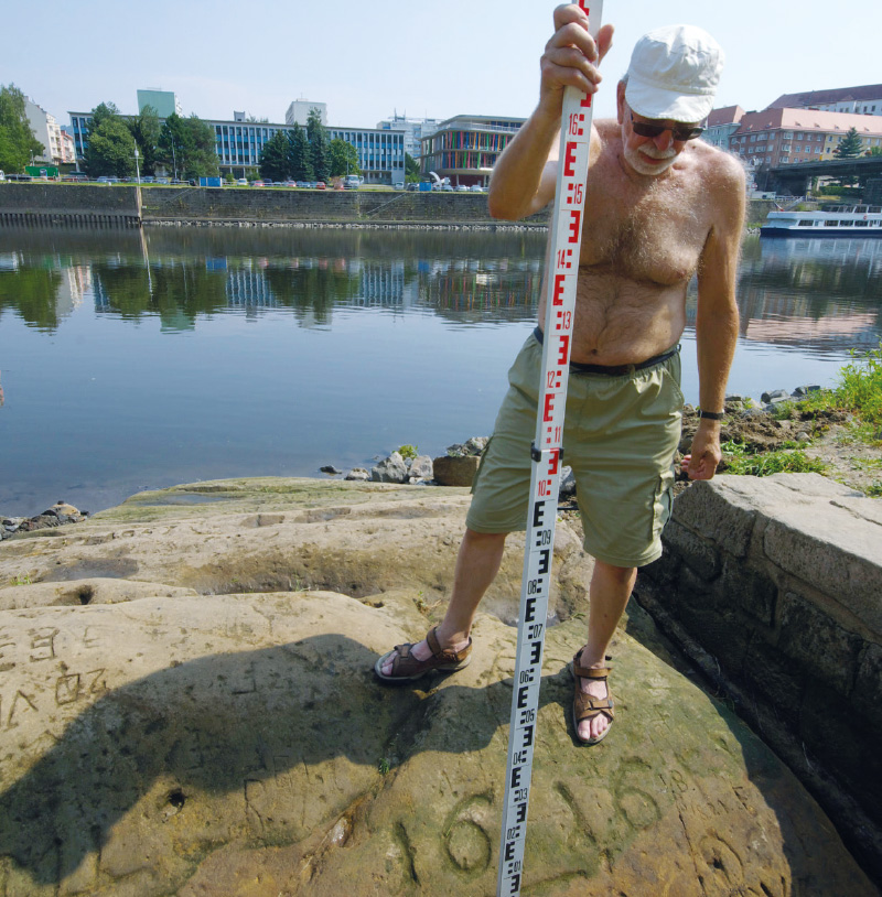
A photograph of Ladislav Kašpárek acting as a scale figure, holding a rod above the 1616 mark.
How did Ladislav Kašpárek support you in your work on historical hydrology?
Later, when I began my dissertation, he offered to collaborate on the evaluation of the 2002 flood, specifically in searching for historical parallels to that event. This form of cooperation continued further, also leading to co-authorship of IF articles. I prepared historical materials for various studies, including work on the Rakovnický Stream. Very often, I simply asked him whether this or that was a good idea. To conclude, I would like to share a memory that contains neither a humorous punchline nor a hidden deeper meaning. It is, however, a memory that I enjoy recalling in my mind. It relates to the catastrophic period of drought. Hydrological drought began to manifest as early as 2014 and continued until spring 2020. Every cloud has a silver lining: we had long awaited the opportunity to observe the hunger stone in Děčín rise as much as possible above the water. The best chance to record all thirty markers of minimum water levels on its surface came in August 2015. After phone calls and some theoretical preparation, Ladislav Kašpárek organised the expedition. We travelled in an off-road vehicle driven by Jan Kašpárek, his son. Naturally, the surveyor Zvonimír Dragoun, an indispensable collaborator, accompanied us. Excavating and cleaning the stone is a task for four people, taking roughly half a day. Despite the contribution of the Vltava cascade, the water level had dropped very low, so all the markers were clearly visible. That day – I believe it was 14 August 2015 – the afternoon temperatures in Děčín reached around 38 °C, yet Ladislav handled the spade with great skill. By around three o’clock, however, we had all had enough. The stone was fully excavated and clean. At the side, where the famous inscription reads “Wenn du mich siehst, dann weine” (“If you see me, weep,” editorial note), something else appeared beneath the water – perhaps a five-pointed star. Was there a marker somewhere beneath it as well? We could not go any deeper, unless the outflow from the Střekov weir was temporarily reduced. Calmly, Ladislav said, “Well, let’s build a little dam then.” We quickly constructed a small barrier around the side of the stone. We removed the water using a plastic mineral water bottle and, I believe, even a pump originally intended for cleaning and rinsing the stone. It was a battle between seepage and the pump’s capacity. Jan Kašpárek shovelled gravel and mud tirelessly until the job was done. In the process, he unearthed the lowest marker from 1934. It turned out that the measurements previously taken at the gauge and the heights of the markers matched almost exactly. The difference between the annual minimum recorded at the gauge in 1868 and the corresponding marker was zero! We used the same, slightly refined, method again when scanning the stone in 2018.
Which joint project or topic would you consider central to your collaboration?
If I were to identify the common thread of our collaboration, it would almost certainly be the flood of May 1872. Since 1981, this flood never left Ladislav Kašpárek’s mind; he returned to it again and again. He initiated renewed work on the topic in 2000, which involved field surveys along the Střela and Blšanka streams. Subsequent steps focused on more detailed information about damage to water mills and ponds, as well as using Aqualog for re-simulation. The final step was the estimation of the Rakovnický Stream’s flow, culminating in the book on historical floods (Historical Floods on the Rakovnický Stream, editorial note). After the joint lecture presenting this book on 18 March at TGM WRI, we spoke for another two hours in the office. Eventually, we went to his archive in the corridor and up to the attic. He pointed out the essential items that should be preserved. Sadly, this is now the very last memory…
Dr Elleder, we sincerely thank you for the interview and for providing the photographs.
Ing. Libor Elleder, Ph.D.
Ing. Libor Elleder, Ph.D., was born on 11 July 1963 in Prague. He studied at the Faculty of Civil Engineering at Czech Technical University, specialising in Hydraulic Structures and Water Management. He focused on hydrology, including his master’s thesis on Automatic Optimisation of a Hydrological Tank Model. After completing his studies, he joined the Czech Hydrometeorological Institute. Until 1993, he worked in the Data Regime Processing Department, focusing on flood recurrence intervals calculations, generation of synthetic series, and data processing in unmonitored profiles, also serving as a programmer for a range of tasks. From 1993 to 2013, he worked as a forecaster, specialising in hydrological predictions. Since the 1990s, he has also been engaged in historical hydrology. In 2009, he defended his doctoral dissertation at Charles University on The Use of Proxy Data in Hydrology. Since 2013, he has worked in the Department of Applied Hydrology, focusing on research. He has co-authored and authored numerous scientific articles, contributed to several professional books, and worked on an ArcGIS-based application for flood mapping. Currently, he is a member of the Floods Working Group Pages and collaborates with the Working Group for the History of Hydrology.
