ABSTRACT
Assessment of the hydromorphological status and its elements (hydrological regime, continuity, morphological conditions) is part of the monitoring of the ecological status of water bodies. Hydromorphology, as a supporting component of biological assessment, has a significant impact on living organisms in aquatic ecosystems. Although the Ministry of the Environment of the Czech Republic (MoE) previously officially approved a methodology for monitoring and assessing the hydromorphological status of waterbodies (HEM methodology), it was only used to a limited extent. In the case of the third river basin management plans, hydromorphology was assessed exclusively based on remote sensing data according to the Procedure for Determining Significant Impacts on Morphology and Hydrological Regime. Based on the Ministry’s request, a new methodology for assessing the hydromorphological status of water bodies category rivers (HYMOS) was developed within the TA CR project. This methodology takes into account new requirements and current knowledge in the field of hydromorphology, while also minimizing the drawbacks of previous methodologies, particularly regarding time and cost efficiency in the assessment process. The final version of the methodology was tested on 15 water bodies divided into 50 reaches. A score was calculated for each of these reaches to assess the hydrological regime, continuity, morphological conditions, and overall hydromorphological status. Subsequently, a score for the entire water body was determined, including classification into a status category. The assessment results indicated that for large watercourses, where anthropogenic influences are reflected over long reaches, the aggregated value for the entire water body often provides sufficiently meaningful information. In contrast, for water bodies including small and medium-sized watercourses, which are heterogeneous in terms of hydromorphological types and anthropogenic pressures, assessments at the water body level are overly aggregated and fail to identify critical segments. While reporting the status of water bodies requires presenting data for the entire water body, designing measures to improve hydromorphological status benefits from working with detailed reach-level data. Therefore, the HYMOS methodology combines detailed and aggregated approaches, making it a flexible tool suitable for both strategic planning at the water body level and for assessing local reaches in relation to implemented or planned measures.
INTRODUCTION
The Water Framework Directive (WFD) (2000/60/EC) [1] obliges EU Member States to assess the hydromorphological status of surface waters. Together with biological, chemical, and physico-chemical components, it forms part of the monitoring of the ecological status of water bodies. The term “hydromorphology” includes information on geomorphological and hydrological processes occurring in watercourses, including their longitudinal, lateral, and vertical continuity. According to the WFD, the assessment of the hydromorphology of water bodies of the river category is divided into three main elements:
- hydrological regime,
- watercourse continuity,
- morphological conditions.
The objective of the hydromorphological assessment is to determine the extent of anthropogenic influence on water bodies within these elements. The hydromorphological assessment is used in many steps of the planning process under the WFD. It plays a role in defining water bodies, analysing significant impacts, determining heavily modified water bodies, selecting the location of monitoring profiles and, last but not least, in designing effective measures to achieve good status or potential of a water body, which is the main objective of the WFD. The basic legislative document regulating the assessment of the hydromorphological status of water bodies at the European level is the aforementioned WFD. In Czech legislation, this issue is regulated by Act No. 254/2001 Coll., the so-called Water Act, and Decree No. 98/2011 Coll., which determines the method and scope of the surface water status assessment. The correct and consistent implementation of the WFD in accordance with the European Union objectives is supported by the methodological guidelines of the Common Implementation Strategy (CIS) and the relevant standards. In the field of hydromorphological assessment, these are the standards ČSN EN 14614 [2] and ČSN EN 15843 [3].
In the Czech Republic, the hydromorphological status of water bodies is currently formally assessed using the Hydroecological Monitoring (HEM) methodology [4, 5], which has been officially accepted by the Ministry of the Environment (MoE). However, this methodology has only been used to a limited extent and the assessment data have not yet been officially reported as part of regular reports on the status of water bodies. The methodology users often pointed out its time-consuming nature, especially in collecting field data and subsequent calculations, as well as a higher degree of subjectivity in assessing individual indicators. Although the methodology meets the basic requirements of Czech and European legislation, significant progress has been made in the field of assessing the hydromorphology of watercourses since its inception, which has also been reflected in the updates of the relevant standards. This development has shown the need to revise the existing approach so that it better reflects new requirements and current knowledge. In response to these challenges, a new methodology for assessing the hydromorphological status of water bodies was developed within TA CR project No. SS05010135 “Development of a methodology for monitoring and assessing hydromorphological characteristics of watercourses”, referred to by the acronym HYMOS – Methodology for assessing the ecological status of flowing surface water bodies (river category) using hydromorphological elements. The aim of this article is to briefly introduce this methodology and show its applicability using the example of the assessment of 15 selected water bodies in the Czech Republic.
METHODOLOGY
HYMOS Methodology
General characteristics of the methodology
The methodology was developed primarily for the assessment of flowing surface water bodies, both natural and heavily modified. However, it is not intended for the assessment of artificial water bodies. Considering the need for a flexible approach to the assessment of hydromorphology, it was also designed to allow the assessment of watercourses that are not defined as water bodies. In developing the methodology, emphasis was placed on the legislative framework and standards listed in the introductory chapter. The results of the European project REFORM (REstoring rivers FOR effective catchment Management) [6] and the Morphological Quality Index (MQI) methodology [7], which was developed within the aforementioned project, played a significant role in its development. Based on new findings from the REFORM project and the MQI methodology, the EN 14614 standard (2020, original version approved in 2005) has been updated. The procedure for the identification of significant impacts on morphology and hydrological regime [8] was also an important starting point for the development of the new methodology.
Based on current requirements and recommendations, the HYMOS methodology includes both the assessment of forms and processes, while monitoring processes not only in the assessed reach, but also above it, for example influencing sediment transport affecting the deepening of the watercourse downstream. The methodology views watercourses as dynamically changing systems that develop over time, with a possible change from one channel planform to another. For this reason, the methodology does not determine a reference status based on archival maps, although archival maps serve as an important basis for identifying anthropogenic modifications in the past. The full version of the methodology is freely available on the official website of the HYMOS project (https://hymos.czechglobe.cz/) [9]. From the website, the user also has access to a specialized database [10], which contains morphological characteristics of water bodies and defined reaches, as well as to a web application and software for automating the assessment of hydromorphological status [11].
Reference conditions
As opposed to previous methodologies, reference conditions are not determined as specific characteristics of individual assessed indicators for individual types of watercourses, e.g. in the form of precise values of the variability of the riverbed width or the number of natural substrate types. In the past, this approach often led to inaccuracies in the assessment. The reference conditions are now defined in accordance with the WFD and the findings of the REFORM project as follows:
- for indicators expressing the effects of anthropogenic pressures (e.g. bank stabilization, channel bed modification), reference conditions are defined as the absence of pressures or their minimal presence, which does not have a significant impact on fluvial processes, morphology, or natural development of the channel;
- for indicators expressing the “functionality” of a watercourse and its response to anthropogenic pressures (e.g. bed substrate, bed elements), reference conditions are defined as the presence of forms and processes that are expected for a watercourse located in given physical-geographical conditions (e.g. valley slope and shape, intensity of sediment input).
This method of determining reference conditions places higher expert demands on the methodology users. In order to facilitate the assessment as much as possible, a hydromorphological typology of watercourses was created within the HYMOS project. It is based on a combination of the following key parameters: valley slope, confinement index (the ratio of floodplain width to channel width), potential input of coarse sediments to the river, and the size of a watercourse (according to Strahler stream order). Based on these parameters, hydromorphological types of watercourses were created, with accompanying descriptions of characteristic morphological parameters of the river. These descriptions serve as a guide for hydromorphological assessment. The parameters entering the typology are also used when dividing water bodies into (relatively) homogeneous reaches, which allows for a more accurate and consistent assessment.
Division of water bodies into reaches
Water bodies defined in the Czech Republic often show a high degree of inhomogeneity. Within a single water body, there are usually different hydromorphological types of watercourses, which differ in their response to anthropogenic pressures. This definition is not fully in line with the WFD requirements or with the recommendations of the CIS Guidelines No. 3 and 10 [12, 13]. Given the requirement to maintain the existing definition of water bodies, it was necessary to divide them into more homogeneous reaches for the purposes of assessing hydromorphological status. The following criteria were used to define the reaches:
- hydromorphological typology parameters – valley slope and shape, potential input of coarse sediments, and size of the watercourse;
- channel planform – e.g. change from meandering to straight or otherwise modified planform;
- the occurrence of structures affecting the longitudinal continuity of the watercourse – primarily dams of water reservoirs, flow-through ponds and other barriers that disrupt the flow natural processes and sediment transport;
- riparian zone use – changes between natural vegetation cover, cultural landscape, mosaic landscape, and built-up areas serve as placeholder information for potential changes in riverbed morphology.
Basic characteristics of the defined reaches, such as the slope of the valley and the watercourse, confinement index, stream order, and other relevant parameters are available in a publicly accessible database on the HYMOS project website [10].
The assessment of hydromorphological indicatorsis carried out at the level of these reaches, and the methodology allows a choice of two assessment approaches. Both approaches comply with legislative requirements and their choice is left to the methodology user:
- Assessment of the entire reach length: This approach provides the most accurate picture of hydromorphological status as it reflects all characteristics within the entire reach. The disadvantage is that it is time-consuming, especially when collecting field data.
- Assessment on a shorter representative “sub-reach”: Assessment is carried out on a selected sub-reach; subsequently, its characteristics are extrapolated to the entire reach. This approach is less time-consuming, however, provides less detailed information on the hydromorphological status. The choice of sub-reach is key to ensuring representativeness of the results.
Indicators for assessing hydromorphological status
The indicators used to assess the hydromorphological status and its elements (hydrological regime, continuity, and morphological conditions) are based on the requirements defined in the ČSN EN 14614 standard. The selection of indicators is based on current scientific knowledge and their demonstrated relationship to the assessed biological components, such as fish, macrophytes, or macroinvertebrates.
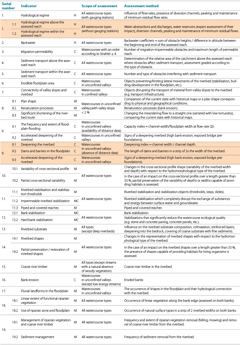
Each indicator is defined in terms of its function in the assessment and scope of application, i.e. for which types of watercourses it is applicable. An overview of the indicators is given in Tab. 1, which contains a brief description of the assessment method and specifies to which types of watercourses the given indicator applies. As opposed to previous approaches, it is no longer necessary to record detailed information for indicators, such as percentages of bed substrate types or channel bed elements, for assessment purposes. Instead, the degree of deviation from the reference status in categories is directly assessed, which significantly reduces the time required for data collection in the field. Indicators are rated in three to five categories, which also contributes to reducing the degree of subjectivity. Field data can be collected directly via a form in the mobile app (a web platform adapted for any mobile device), eliminating the need for additional transcription of data from paper forms. During the testing of HYMOS methodology, the speed of assessment was compared with HEM methodology. The comparison carried out on 15 selected sections of watercourses showed that actual data collection in the field using HYMOS methodology was approximately twice as fast as when using HEM methodology.
Tab. 1. Overview of assessed indicators, their scope, assessment method and the most common data sources for assessment. Indicators highlighted in orange are those evaluated using an alternative approach in cases where the required data – such as remote sensing data or data from gauging stations are unavailable. The letter next to each indicator denotes its affiliation with a specific element of the hydromorphological status (H = hydrological regime, C = continuity, M = morphological conditions)
Principle of calculating hydromorphological status
Indicators are assessed in categories, each of which is assigned a point score. This system allows calculation of the status of all hydromorphological status elements (hydrological regime, continuity, morphological conditions), overall hydromorphological status of the reach and, subsequently, of the water body. Scoring is based on the MQI methodology [7] and was validated and adjusted based on data obtained during the project to correspond to the conditions of the Czech Republic. The point score of category 1, which represents the reference status, is always 0 and with an increasing value of the assessment category, which signals a higher degree of anthropogenic influence, the point score also increases.
The assessment of the hydromorphological condition is calculated as the sum of points obtained from the evaluation of individual indicators, which is then divided by the maximum possible score for the given indicators. Each indicator influences the final assessment to a different extent. The calculation is performed according to the following formula:
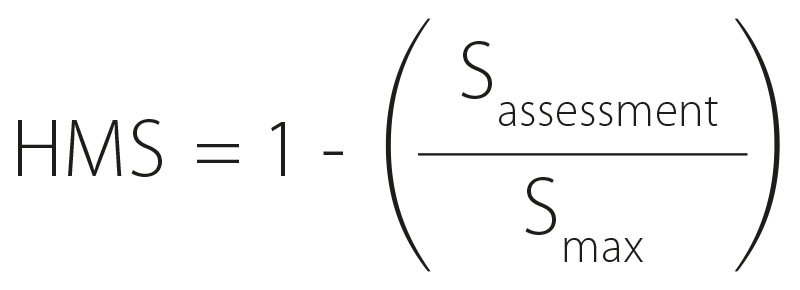
where:
HMS is hydromorphological status
Sassessment the sum of the points obtained by assessing the indicators
Smax the maximum sum of the points for the assessed indicators
Indicators that are not assessed are not included in the calculation of the maximum score. This calculation procedure is also used for the individual hydromorphological elements.
When calculating the score, the assessment reliability is also considered. If the assessment of an indicator is less reliable (e.g. due to lack of or incomplete data), the user marks two assessment categories and then the difference between these categories is calculated and the deviation caused by this uncertainty is included in the overall score.
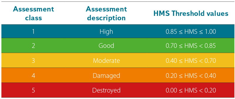
The calculated score for hydromorphology and its components ranges from 0 to 1, with a value of 1 corresponding to natural conditions and 0 indicating heavily degraded conditions. Threshold values for individual assessment classes are given in Tab. 2. Calculations are performed automatically by the software, based on the assessment entered into the form in the web app.
Tab. 2. Threshold values for the assessment of hydromorphological status and its elements
For reporting purposes, assessment result for the entire water body must be provided. This can be calculated using the following formula:
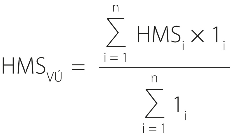
where:
HMSVÚ is hydromorphological status of the water body
HMSi hydromorphological status of the i reach
li the length of the i reach
Water body assessment
HYMOS methodology was applied to 15 selected water bodies, which are evenly represented in all main river basins of the Czech Republic – three water bodies in each river basin. For the purpose of demonstrating applicability of the methodology, water bodies were selected that cover different hydromorphological types of watercourses, i.e. streams with different slopes (high/low), in confined and unconfined valleys, small and large streams, with different intensities of coarse sediment input. Another selection criterion was the intention to include water bodies with different intensities of anthropogenic pressures. An overview of the selected water bodies, including their division into reaches, is shown in Fig. 1.
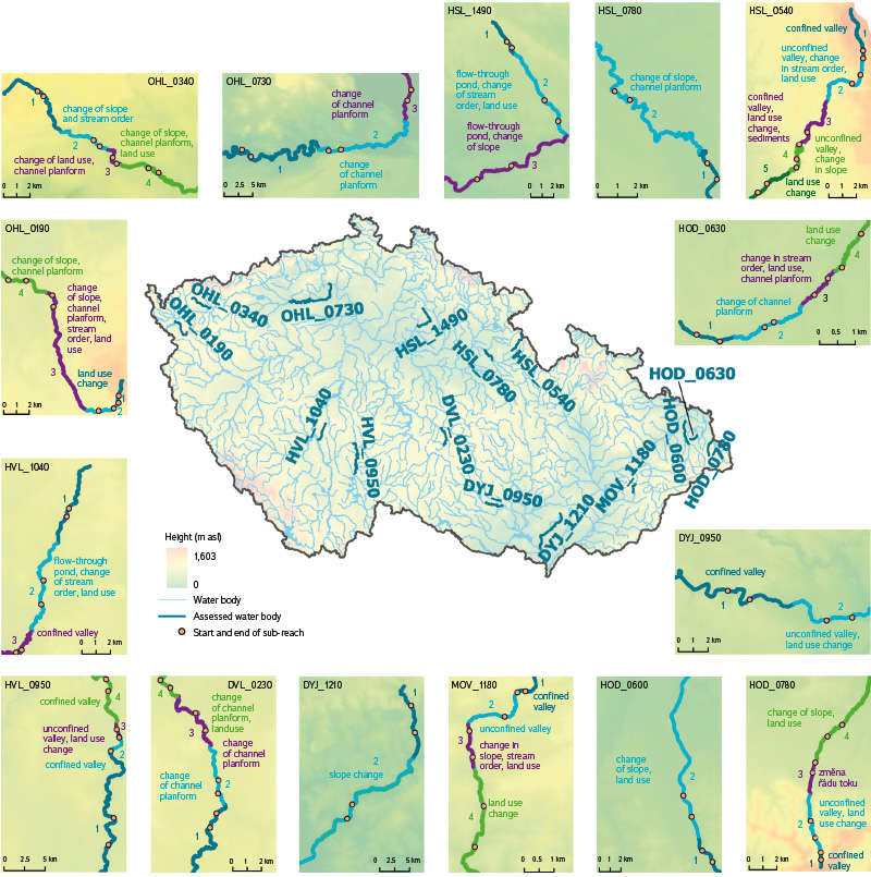
Fig. 1. The map depicts the selected assessed water bodies (their full names are listed in Tab. 3), the division of water bodies into reaches (reaches are colour-marked, their numbering corresponds to Tab. 3), and the parameters used for this division. It also shows the sequential numbering of reaches and the location of sub-reaches where field assessments were conducted (abbreviations used: průt. rybník = flow-through pond, půd. tvar = channel planform)
Indicators 1 to 8 and 18 (listed in Tab. 1) were assessed over the entire reach length based on remote sensing data. Indicator 9, relating to the periodicity and extent of floodplain flooding, was assessed over the entire length, if the relevant remote sensing data were available (floodplain extent layer for a 5-year recurrence interval). The remaining indicators were assessed within shorter sub-reaches (Fig. 1). The sub-reaches were defined based on an analysis of the land use in the strip around the watercourse, aerial photographs, virtual
RESULTS AND DISCUSSION
A total of 15 water bodies were assessed, which were divided into 50 reaches. For each of these reaches, both the score for individual elements of hydromorphological assessment (hydrological regime, continuity, morphological conditions) and overall hydromorphological status were calculated. Each reach was also assigned to the corresponding classification class. The summary results are presented in Tab. 3.
Tab. 3. Results of the assessment of selected water bodies – results for river reaches and entire water bodies
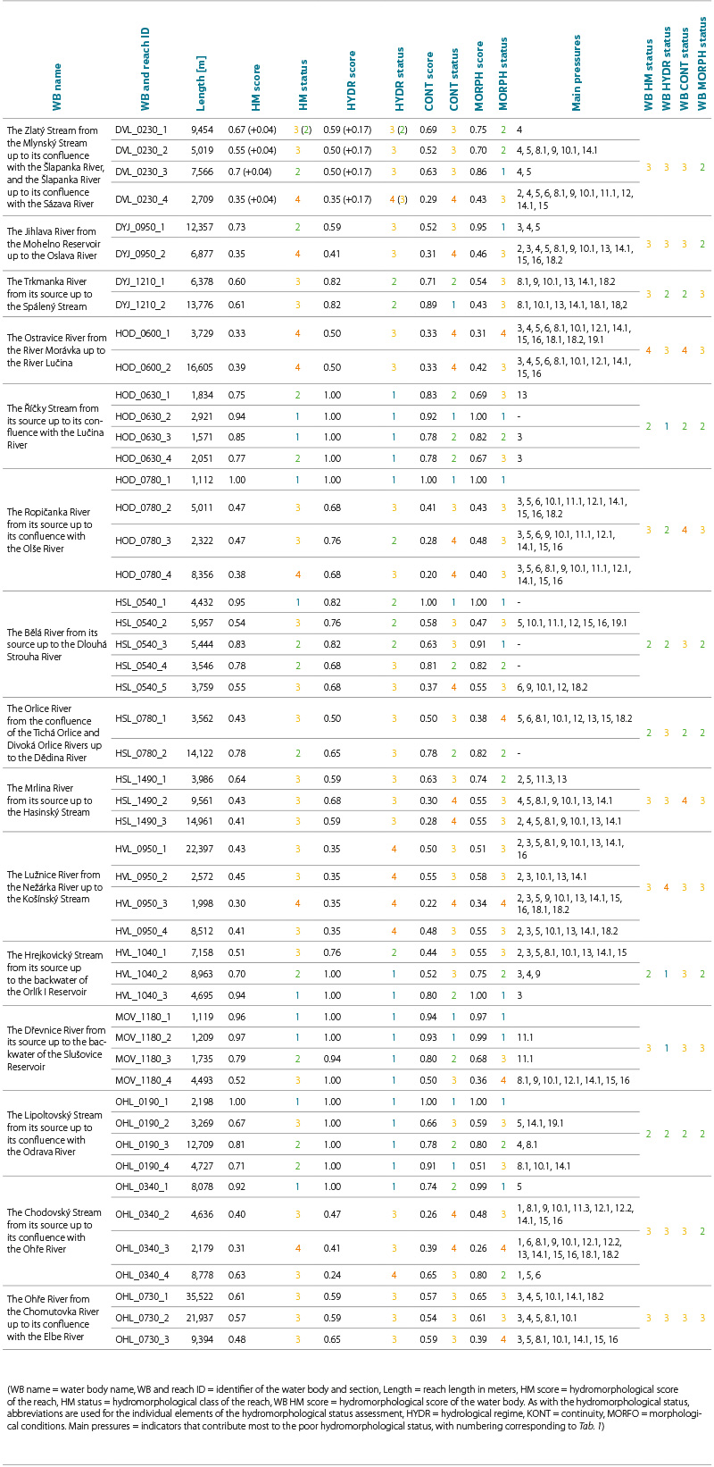
Almost half of the assessed reaches were classified as class 3 based on the degree of hydromorphological impact. Eleven reaches were in good status, nine in very good, and seven were assessed as poor. No reach was classified as bad (classification status 5) High status was typical for parts of the watercourse in the upper reaches with a steep slope, often in confined valleys. However, these parts usually only represent a smaller proportion of total water body length. Longer reaches with high status are only found in the Říčka water body, from its source to its confluence with the Lučina watercourse. Reaches in confined valleys, where the intensity of anthropogenic modifications is usually lower (e.g. lower part of Hrejkovický stream), were also found to be in good or high status. Reaches of Lipoltovský stream, the meandering parts of the Orlice and the Šlapanka water bodies can also be described as ecologically valuable.
Analysis of the main anthropogenic pressures and the response of watercourses to their effects (Fig. 2) showed that the most common reason for the impaired result of hydromorphological assessment was modification of the channel planform. This type of modification is often associated with low cross-sectional variability and insufficient presence of the corresponding riverbed elements. Other pressures include disruption of the watercourse longitudinal continuity, which limits sediment transport and fish migration. In more than one third of cases, the absence of bank erosion and large wood also contributed to lower assessment. Field data show that, despite modifications to the cross-sectional profile, banks are usually not stabilized over long reaches. This provides a suitable condition for spontaneous renaturation during floods, especially in streams with higher energy (watercourses with a more pronounced slope, flow rate, and narrower undersized channel).
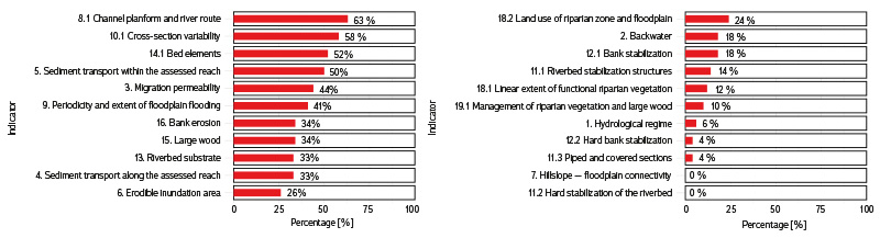
Fig. 2. Relative frequency of occurrence of indicators (main pressures) contributing to the impaired status of assessed reaches
For the purposes of reporting under the WFD, it is necessary to calculate the hydromorphological status and its elements for water bodies. The assessment of selected water bodies is given in Tab. 3. However, this approach has certain limits. Water bodies usually include different hydromorphological types and are exposed to different anthropogenic pressures that differ in intensity; from this point of view, they are not homogeneous. The calculated classification level value is a weighted average of assessments for individual water body reaches. Analysis of selected water bodies shows that the calculation for one body can only be sufficient for large watercourses, where anthropogenic influence is manifested over long distances.
Examples are the Ohře water body from the Chomutovka stream to the mouth of the Elbe, the Lužnice water body from the Nežárka iver to the Košínský stream, and the Ostravice water body from the Morávka river to the Lučina stream. In the case of smaller and medium-sized watercourses, assessment for the water body is usually too aggregated. A good example is the Bělá water body, from the source to the Dlouhá strouha stream, where reaches in a confined and unconfined valley alternate, and each of these reaches shows a different degree of anthropogenic influence (Fig. 3). Although it is necessary to calculate values for the water body for reporting purposes, more detailed information for individual reaches also represents an important basis that can support more accurate identification of critical reaches and more effective design of measures by environmental protection authorities and watercourse managers.
Reach 1 – confined valley with a steep slope (over 2 %), no anthropogenic pressures (high status)
Reach 2 – unconfined valley with a steep slope (over 2 %), modified channel morphology and disruption of longitudinal continuity (moderate status)
Reach 3 – confined valley with a slope over 2 %, anthropogenic pressures caused by local disruption of longitudinal continuity and limited connectivity between valley slopes and the channel due to road infrastructure (good status)
Reach 4 – unconfined valley with a slope of 0.5–2 %, local modifications of the cross-sectional profile (good status)
Reach 5 – unconfined valley with a slope of 0.5–2 %, flowing through a village
and its built-up area (moderate status)
Reach 5 – unconfined valley with a slope of 0.5–2 %, flowing through a village and its built-up area (moderate status)
Fig. 3. Reaches of the Bělá water body from its source to the Dlouhá strouha stream, illustrating the variability of physico-geographical conditions and the influence of anthropogenic pressures
CONCLUSION
In this paper, we have presented a new methodology for assessing hydromorphological status of flowing water bodies. Compared to previous methodologies, the main advantages can be considered the following:
- Working with distance data
10 out of 19 indicators can be assessed based on remote sensing data, with selected indicators already being assessed within the project.
- Reducing time requirements
The defined methodology, software, and apps enable fast and efficient data collection in the field and immediate assessment of hydromorphological status without the need for transcribing field data and further calculations. HYMOS methodology is up to twice as fast as HEM; when testing during the project, its user needed only half the time compared to the user of HEM methodology.
- Reducing subjectivity of assessment
Assessing indicators in categories and the method of defining the assessment increases the probability that two different assessors will assess the same indicator identically.
- Ensuring consistency between the calculated hydromorphological status and the conditions observed in the field
The defined assessment gives the assessor greater freedom in the assessment, thus preventing situations where, in the past, a watercourse was assessed according to a type that does not correspond to its actual character.
- Analysis of main anthropogenic pressures and response of watercourses to their effects
After calculation, the software shows which indicators contributed most to poor hydromorphological status, which allows for precise identification of the main anthropogenic pressures acting in the assessed reach.
HYMOS methodology meets current requirements of the WFD and the ČSN EN 14614 standard for assessment of hydromorphological elements of water bodies; it also allows for assessment of watercourses that are not defined as water bodies. In the methodology, watercourses are seen as dynamically changing systems, which shifts the emphasis to assessment of processes such as sediment transport, bank erosion, or riverbed development. The methodology also considers anthropogenic changes above the assessed reach, which can affect processes and shapes in the given reach. Although the methodology is designed for a comprehensive assessment of these processes, it is not intended for monitoring very small changes that are difficult to define with a categorized assessment. Compared to previous methodologies, HYMOS methodology brings significant changes in the approach to assessing hydromorphological status. Nevertheless, a number of recorded parameters, such as transverse structures in the channel or stabilization of riverbanks and riverbed, remain the same or differ only minimally. Thanks to this, data obtained using older methodologies can also be used for assessment according to HYMOS methodology, especially if the original definition of the assessed reaches is maintained. In the event of a change in their definition, the need to reassess percentage values related to the length of the reach cannot be ruled out in order to correspond to the new definition.
HYMOS methodology allows for assessment of hydromorphological status at the level of individual homogeneous reaches, which provides valuable information for detailed analyses and planning of measures. Based on these partial assessments, an aggregated value of hydromorphological status for the entire water body can then be calculated, which is required for reporting purposes in accordance with the WFD. This combination of detailed and aggregated approaches makes HYMOS methodology a flexible tool that can be used not only for strategic planning at the water body level, but also for assessment of local reaches in connection with implemented or planned measures.
Due to the project timeframe, it was not possible to use HYMOS methodology for assessing the hydromorphological status of watercourses in the third planning cycle. However, its application is expected in subsequent planning cycles, which are planned at least at the national level. The importance of the hydromorphological status of watercourses is also highlighted in the Nature Restoration Law (Regulation (EU) 2024/1991), approved last year, which places emphasis on the restoration of free-flowing rivers. HYMOS methodology [9] was developed with these requirements in mind and provides broad analytical and methodological support for their fulfilment.
Acknowledgements
The creation of the methodology and the preparation of this article were supported by the project of the Technology Agency of the Czech Republic No. SS05010135 “Development of a methodology for monitoring and assessing hydromorphological characteristics of watercourses”.
The Czech version of this article was peer-reviewed, the English version was translated from the Czech original by Environmental Translation Ltd.
