ABSTRACT
The CHMI Ostrava branch has repeatedly had the opportunity to measure water flumes, mostly during verification measurements of minimum residual flows, measurements for structural wear, or revision of flow measurement curves. As part of these measurements, it was a very valuable experience to get to know these undoubtedly very interesting waterworks, which are often also technical monuments. Part of these activities included measurements and subsequent modelling of Weisshuhn flume in Žimrovice. This article summarizes and comments on the partial results of these activities. One of the tasks was to determine the critical points in terms of water losses in the Weisshuhn flume. Although these phenomena do occur, the numbers are not significant, as illustrated by the results of measurements and modelling. Different types of devices were used for the measurements; mostly ADCP devices, namely RDITeledyne StreamPro, SonTek RiverSurveyor M9, and SonTek Teledyne RS5. MIKE 11.
HEC-RAS hydraulic models were used to simulate steady and unsteady flow.
INTRODUCTION
We classify water flumes among the anthropogenic constructions that had a great influence on shaping our cultural landscape in the past centuries [1]. It goes without saying that it is necessary to care for flumes not only from the conservation point of view, but also from the point of view of hydrological and hydraulic aspects. The primary function of flumes is water transport and the subsequent use of water energy for specific purposes. In the past, it was mainly in mills, sawmills, factories for processing of textile raw materials, and paper mills. Transfer can take place within the basin, but we often come across flumes that transfer water between several basins.
The Harappan culture was the first in history to engage in the construction of flumes, in the Bronze Age, but their construction continued even further – through the Roman period and the Middle Ages until the onset of the industrial revolution [2]. The precision and quality of the construction of these important hydrological structures still fascinate us today because many medieval projects still fulfil their function; for example, the channels within the Třeboň system, the surroundings of Pardubice (Opatovický kanál, Zminka), and Poodří PLA [3].
Flumes, as artificially constructed water channels, increase the density of the river network, influence the flow regime of water and sediments, groundwater conditions, and also vegetation. It should be noted that flumes are anthropogenic landforms that can be classified as the initial stage of channelization of watercourses in our country [1].
Many years have passed since the beginnings of the flume construction, and therefore the flumes may be in an inoperable condition; in the event that we would like to restore their function, it is necessary to assess their technical condition. Restoring the function of flumes is becoming relevant due to extreme climatic fluctuations in the form of long dry periods or intense floods. They could be restored in order to improve the discharge in watercourses in dry season, or, after consideration of the flume capacity, they could also be used to transfer flood discharges [3].
In the Jeseníky Mountains, the energy of watercourses has been used since ancient times by means of flumes, which were often supplemented by a system of small water reservoirs. Interesting constructions in this location include, for example, Hanušovický flume, the flumes in Horní Morava and Krupá, as well as the flumes in the Černá Opava basin. One of these flumes, in Nízký Jeseník, is the flume in Žimrovice, the so-called Weisshuhn flume [3].
Carl Weisshuhn (1837–1919), a well-known entrepreneur and builder, is responsible for several important buildings in Opava district and Silesia. In the second half of the 19th century, he became famous for building bridges, viaducts, mountain railways, and standard railways. In 1891, he built a 3.6 km long flume bringing water to the newly built paper mill in Žimrovice. Water flows into the flume from the left bank above Weisshuhn weir, situated on the meander of the Moravice river, and flows around the rocky slopes below Kozí hřbet. The flume route is led through three tunnels carved in the rock and two aqueducts crossing the tributaries of the Moravice – Kamenný stream and the nameless stream. The flume channel is rectangular and trapezoidal in shape, 4–5 m wide, and originally lined with stones, while part of it is built in bedrock. At the end of the flume there is an outlet for ice and mud [4, 5].
To start with, the paper mill included one grinding mill with five horizontal grinders, one turbine, and one paper machine. At the beginning of its operation, the paper mill was able to produce up to 8,000 kg of paper per day. At that time, water flowed through Žimrovice flume to the paper mill at a speed of 4 m3 per second, which doubled the output to almost a thousand horsepower [6].
Žimrovice paper mill developed significantly at the turn of the 19th and 20th centuries, when Weisshuhn received a permit to float wood that was harvested from the forests growing around the Moravice river [6]. In favourable hydrological situations, especially during spring snowmelt or autumn rains, the wood (in the form of a metre-long log stripped of the bark) was floated up to Weisshuhn raft at Kozí hřbet and from there to the factory [7].
An interesting fact is that between the railway station in Hradec nad Moravicí and Žimrovice paper mills, Weisshuhn also had a 4,100 m long narrow-gauge line built around the Moravice river from Weisshuhn weir to the paper mills, which was referred to as “Pifka”. This line was mainly used to transport old paper from Hradec railway station to Žimrovice [8].
Wood was floated by the flume until 1966; however, the plant was nationalized in 1946 and since then the operators have changed several times. The flume has remained functional and water intended for the production of electricity flows through it, supplying the still functioning paper production [3]. Fig. 6. shows a map showing the area of interest.
Field work and measurements
For a better understanding of the influence of the flumes on the landscape (and more specifically on its hydrological regime), apart from the literature search, it was necessary to carry out field measurements and survey. At Weisshuhn flume in Žimrovice (Žimrovice flume), both field mapping and surveying of objects (geodetic GNSS, total station) were carried out, as well as hydrometric measurements – a hydrometric propeller was used as well as a water flow meter (OTT MF Pro) and acoustic devices (ADCP Teledyne RDI StreamPro, SonTek River Surveyor M9 and, in 2024, also the new RS5 and finally also the ADV SonTek FlowTracker2). With the help of these data, it is possible to carry out subsequent analyses in hydraulic models, which enable 1D/2D simulations of steady and unsteady flow and offer rich possibilities for visualizing the results, including partial data exports to the GIS environment. Field measurements, together with subsequent analyses and simulations, allow us to better understand and specify the effects of these constructions on the water regime in the landscape, for example water transfers during floods or, conversely, the influence of flumes in periods of drought [9].
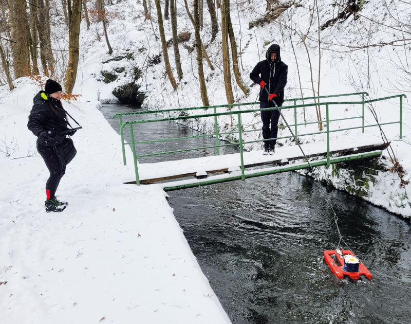
Fig. 1. Discharge measurement using ADCP RDI StreamPro, Weisshuhn flume in Žimrovice, 8th January 2024 (Photo: J. Unucka)
In order to improve the quality of the input topographical and altimetric data for the subsequent schematization of hydraulic models, a geodetic survey of selected sections and objects of the Žimrovice flume was carried out. These measurements were carried out using a total station and a dual-frequency measuring GNSS (Global Navigation Satellite System), which can be used to target objects with very high positional accuracy. In places where hydrometric measurements were carried out, cross sections were also measured using GNSS and a total station. SonTek RiverSurveyor M9 and RS5 ADCP devices also offer the possibility to use GPS data in RTK mode.
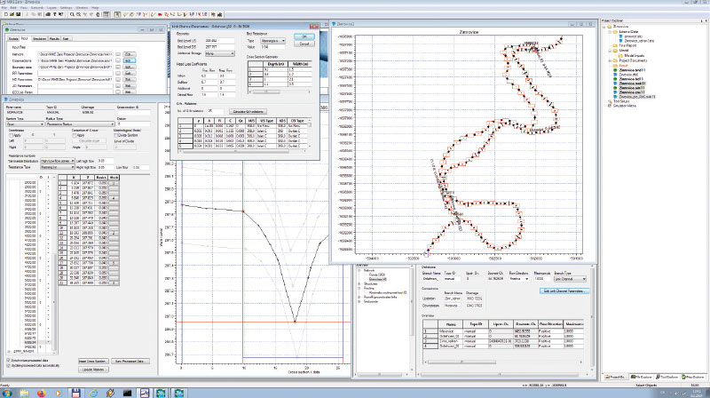
Fig. 2. Example of schematization of the main river Moravice and Weisshuhn flume, MIKE 11 hydraulic model
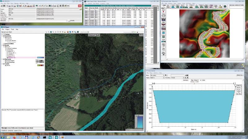
Fig. 3. Example of schematization of the main river Moravice and Weisshuhn flume, HEC-RAS hydraulic model
The measurement of profile velocities was used for the parameterization and calibration of hydraulic models and the construction of measuring flow curves. Thanks to measurements with hand-held or float devices in several determined cross sections downstream, we were able to analyse the drop in Q and, based on these drops, the condition of the flume was assessed in terms of possible leaks and water losses. Despite its age, this flume proved to be in very good condition, and it is admirable how well it was built for its time, when engineering resources and tools were limited. The Q measurement outputs can be evaluated in the Results section in Figs. 4 and 5.
Hydrological modelling
Hydrological (or mathematical) modelling is undoubtedly a tool that is practically indispensable nowadays. Using specialized software, we are able to simulate various scenarios without having to interfere with the real environment. For the needs of the simulation, including the influence of technical structures and water transfers (water distribution works, unloading), it was necessary to choose such software tools that allow simulating also these types of hydrological and hydraulic systems. The HEC-HMS software was used as part of the rainfall-runoff modelling, which is a program that was developed by the US Army and is undergoing continuous development and improvement [3]. HEC-RAS and MIKE 11 were chosen from software tools that focus on the movement of water in riverbeds, whether natural or artificial (hydraulic models in general). All of these program resources mentioned above are FEMA/NFIP industry standards. The MIKE 11 schematization was subsequently imported into the HEC-RAS model, so that the geometric and hydraulic (e.g. roughness of the riverbed) parameters of the schematizations were identical in both models. A big advantage of both models is the possibility to parametrize losses and leaks using the so-called Leakage coefficients.
RESULTS
Figs. 4 and 5 show that the losses caused by seepage are not essential in terms of endangering the immediate surroundings or the functionality of the flume itself. We can say that the work has not lost its hydrological and hydraulic significance even after many years. The output is not only the measured and simulated hydraulic parameters of the flume, but also a partial evaluation of the state of the technical structure. Furthermore, on the basis of the obtained results, we can compare and analyse the extent to which the outputs from hydraulic model simulations are usable, in this case specifically the HEC-RAS and MIKE 11 models. It should be emphasized that, despite the complicated hydraulic conditions, the outputs from the models are very accurate and approach the actual measured flow rate in situ. For further evaluation of hydrological-hydraulic parameters and the significance of the flume during the flood or drought period, further measurements and then simulations in HD models can be carried out, which will help to better understand and define the significance of these structures in the landscape.
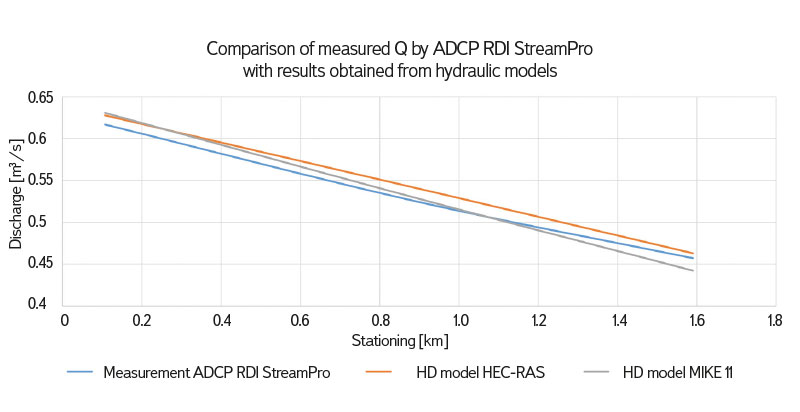
Fig. 4. Comparison of measured and simulated discharges during low flow episodes
We can compare both graphs, where the Q values are measured and then simulated for lower water bearing on the first one, and the same was done for higher water bearing on the second one (Fig. 5)
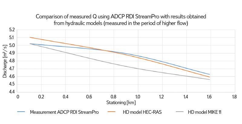
Fig. 5. Comparison of measured and simulated discharges during high flow episodes
CHMI Ostrava plans to continue researching old water management structures in the landscape, as they are undeniably interesting works not only from a historical and construction-technical point of view [10], but also hydrological (water transfer) and ecological (refugia or biocorridors for plant and animal species which are tied to aquatic and transitional habitats). Partial results for specific locations are most often presented as part of the regular Vodní mlýny (Water Mills) conference, which is organized by the museum in Ústí nad Orlicí under the leadership of PhDr. Radim Urbánek. The authors hope that a more comprehensive publication will be created in time.
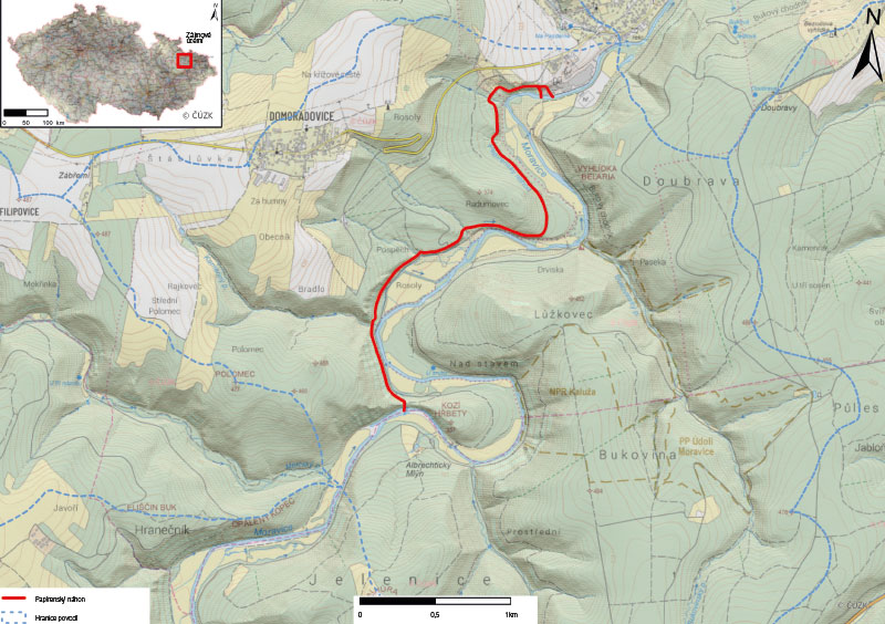
Fig. 6. Location of the pilot area
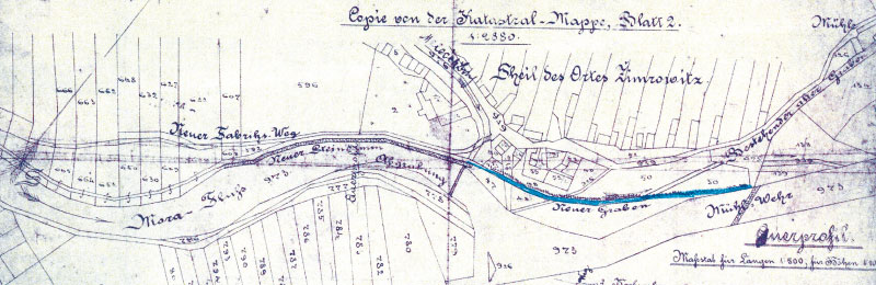
Fig. 7. Historical map of Weisshuhn flume
Although the measurement of flow rates and the modelling of hydraulic processes in the flumes is quite specific, the work done so far at various locations (Žimrovice, Hanušovice, Žďárský stream, Javorka, Ploskovický stream, etc.) points to the fact that appropriately selected instrumentation and software make it possible to obtain usable results.
The Czech version of this article was peer-reviewed, the English version was translated from the Czech original by Environmental Translation Ltd.
