ABSTRACT
This article discusses the development, management, and use of the landscape in the form of a declaration of a Protected Area of Natural Water Accumulation (CHOPAV). It examines the importance of this method of protection in the water protection system under the requirements of the Water Framework Directive and other European directives which have been incorporated into the legislation of the Czech Republic. It looks at the possibilities of using this tool in water management to deal with problems caused by climate change. Based on the research and analysis carried out, the article recommends modifications to the CHOPAV regime and area modifications, as well as expansion to other sites.
INTRODUCTION
In the former Czechoslovakia, water management was handled systematically; legislative instruments, a theoretical approach to water protection, and rational use and development of water resources were at a good standard. Application of the proclaimed principles in practice was less successful. After the Czech Republic joined the European Union, EU directives in the field of water management had to be adopted and reflected in our legislation. There was an effort to preserve all functional instruments and modify them in a form compatible with the requirements of these directives. The main document that was incorporated into the legislation of the Czech Republic was the Water Framework Directive; however, it focuses mainly on the watercourse itself, including its morphology, while paying little attention to the landscape in the basin. Legislative tools used for the comprehensive protection of basins, such as protected areas of natural water accumulation (chránné oblasti pirozené akumulace vod; CHOPAV), have thus become a certain relict in the new water management system.
Current research as well as a number of projects focus on investigating the effects of climate change and the possibilities of mitigating its negative impact. In addition to the search for new procedures and the enforcement of new regulations and decrees, the possibilities of using existing tools are being explored; protection in the form of CHOPAV is one of them.
The knowledge gained during the implementation of the project „ADAPTAN II – Integrated approaches to the adaptation of the landscape of the Moravian-Silesian Region to climate change“ led us to writing this article. We are trying to find an answer to the following questions: In the context of the current ongoing climate change, does the protection of in the form of CHOPAV make sense? And is large-scale nature conservation in the form of national parks (NP) and protected landscape areas (PLA) sufficient enough for surface water and groundwater protection?
METHODS
This issue falls within the responsibility of several ministries; apart from the Ministry for Regional Development (spatial planning), it is also the Ministry of the Environment (water protection) and, in particular, the Ministry of Agriculture. It is responsible for basin management, the provision of drinking water, and connecting municipalities to sewage systems; at the same time, the required measures and regulations affect agricultural management and forestry.
In searching for answers to the above questions, we chose the following procedures: different types of area protection were compared with the requirements imposed by law and government regulations for management and activities in CHOPAV. Subsequently, we analysed the overall relationships within area protection by various legislative tools. For the analysis, we used ESRI ArcGIS geo-information software designed to display and process geographic data using DIBAVOD and ZABAGED databases. Subsequently, we searched for cases where the affiliation of an area to the declared CHOPAV was used to assess the permissibility of carrying out certain activities in the area. One of the important steps was also a comparison of the approach to comprehensive landscape and water protection in the Czech Republic and in neighbouring countries.
Based on discussion of the obtained results, we made concrete proposals and recommendations for the further development and use of water protection through CHOPAV.
RESULTS
CHOPAV in past and current legislation
Searching and linking related legislation brought some fundamental insights.
The first mention of CHOPAV in the Czechoslovak legal environment is in the Water Act of 1973 (No. 138/1973 Coll., Part Three – Water Protection, Section 1 – Protection of Natural Accumulation of Water and Water Resources, Section 18).
It mentions that the government can designate areas with natural conditions for significant natural water accumulation as protected water management areas and prohibit activities that threaten water management conditions in the area. During the period of validity of this law, four amendments were issued which, however, no longer applied to CHOPAV. The individual CHOPAVs were declared gradually with the entry of relevant government regulations into force [1].
In these legal regulations, the overall scope was determined and prohibited activities were defined by name and individually for each area.
In the current wording of the Water Act No. 254/2001 Coll. [2], CHOPAV is mentioned in several sections; the important thing is that this type of area protection is still valid, even after the admission of the Czech Republic to the EU.
According to Section 28 of this law, CHOPAV aims at the preventive protection of areas in which water naturally accumulates against activities that could endanger its quality or quantity. Protection is implemented through exhaustively listed bans (Section 28, paragraph 2), the scope of which is determined by government regulation. The law gives the government general authority to declare protected areas of natural water accumulation and the extent of restrictions or prohibitions of activities that can be implemented in them. Another important provision in Section 108 is that the competence of the central water authority in CHOPAV matters is exercised by the Ministry of the Environment.
The boundaries of the existing areas are defined in Government Regulations (GR) No. 40/1978 Coll., No. 10/1979 Coll., No. 85/1981 Coll., where all prohibitions are defined and later adopted into the currently valid Water Act. They are mainly prohibitions to:
- drain forest land,
- drain agricultural land,
- extract peat,
- perform surface extraction of minerals,
- carry out other work that would lead to the uncovering of a continuous groundwater level.
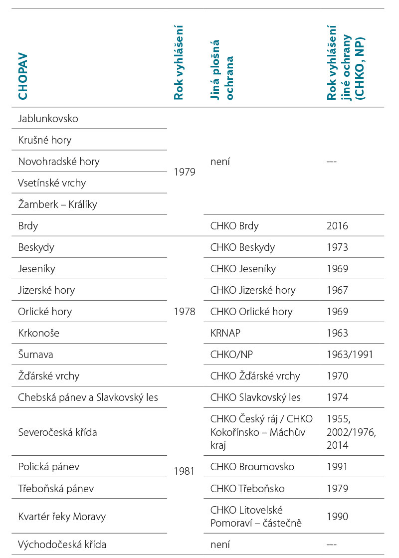
Currently, 19 protected areas of natural water accumulation are declared in the Czech Republic by these government regulations from 1978–1981 [1]. Of this number, 13 areas are focused on surface water protection and six areas on groundwater protection. A summary map of CHOPAV areas including their type is shown in Fig. 1.
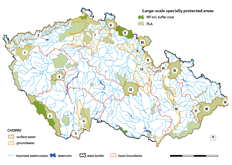
Fig. 1. CHOPAV areas compared with large-scale nature protection – numerical designation of CHOPAV areas (1 – Chebská pánev and Slavkovsk les, 2 – Kruné hory, 3 – umava, 4 – Brdy, 5 – Novohradské hory, 6 – Teboská pánev, 7 – Severoeská kída, 8 – Jizerské hory, 9 – Krkonoe, 10 – Polická pánev, 11 – Orlické hory, 12 – Vchodoeská kída, 13 – árské vrchy, 14 – amberk – Králíky, 15 – Jeseníky, 16 – Quaternary of the Morava river, 17 – Vsetínské vrchy, 18 – Beskydy, 19 – Jablunkovsko)
These areas were declared in accordance with the legislation in force at the time; the question is currently arising about the appropriateness or even the necessity of revising the requirements of the then government regulations with regard to the requirements of the current legislation. We are also considering whether it would be appropriate to establish this type of protection for other areas. Although the conditions for both types of CHOPAV areas are similar, a distinction must be made between areas protected as surface water or groundwater. Fig. 2 shows a comparison of the characteristic differences of the landscape in both types: in the case of groundwater, it is often the protection of the floodplain of the lower reaches of large rivers; in the case of surface water, it is mainly the protection of mountain areas.
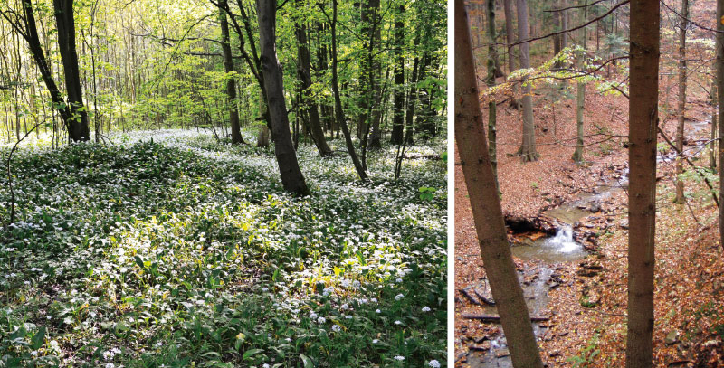
Fig. 2. Landscape in CHOPAV area of groundwater and surface water: Quaternary of the Morava river in Litovelské Pomoraví, Jablunkovsko – upstream of the Lomná river
Relationship between CHOPAV and other large-scale area protection
In the Czech Republic, wildlife and landscape have been protected by legislative tools of various nature since the second half of the 20th century (1955) to the present day (scope of the Act on the Protection of Nature and Landscape No. 114/1992 Coll.).
One of the most important tools for the protection of wildlife and the landscape is the protection of land, which is carried out through specially protected areas. The Nature and Landscape Protection Act [2] defines six categories of specially protected areas, of which national parks (NP) and protected landscape areas (PLA) significantly extend or exceed the area of a total of 13 CHOPAV areas. Other categories, such as national nature reserves (NNR), nature reserves (NR), national natural monuments (NNM), and natural monuments (NM), do not have a decisive influence on activities in CHOPAV, as well as areas included in the Natura 2000 system and geoparks.
Sites where CHOPAV areas were declared are sometimes completely, sometimes partially covered by a PLA or NP (Fig. 1). Their overlap was based on what was protected by the given current legislative tool and what was considered important at that time.
An overview of the scope of CHOPAV areas and their overlap with nature protection areas (PLAs, NPs) is shown in Tab. 1. Litovelské Pomoraví PLA extends only marginally into the CHOPAV area of Quaternary of the Morava river. esk ráj PLA was expanded in 2002, and Kokoínsko – Máchv kraj PLA was also expanded in 2014. In the case of umava, the PLA was declared in 1963 and the NP in 1991. Severoeská kída CHOPAV still extends marginally into the eské stedohoí, Labské pískovce, and Luické hory PLAs, as well as into Bohemian Switzerland NP.
Tab. 1. Relation of areas that belong to water protection under CHOPAV, protected landscape area (PLA), and national park (NP) NP)
Relationship between CHOPAV and the LAPV basin
The area protected as a site for the accumulation of surface water (lokalita pro akumulaci povrchovch vod, LAPV) is a designation for the area earmarked for the possible construction of a water reservoir. Activities are only permitted which do not make it impossible or significantly difficult for the future use of the site for surface water accumulation. For this purpose, the area must be morphologically, geologically, and hydrologically suitable. The area protected for the accumulation of surface water is a legislative term defined in the Water Act, which was added as a part of its amendment in 2008.
Individual areas are listed in the General of Areas Protected for Surface Water Accumulation (General LAPV) [3], which is prepared by the Ministry of Agriculture in agreement with the Ministry of the Environment. The purpose of their protection is that if necessary, these sites can be used in the long term as one of the adaptation measures against climate change. These sites are continuously and repeatedly checked using the latest knowledge about climate development (e.g. Vizina et al. [4]). Sites enter the spatial planning process as a „area reserve“ at the level of the Principles of Regional Development. The second version of General LAPV, published in 2020, is the basis for the map in Fig. 3.
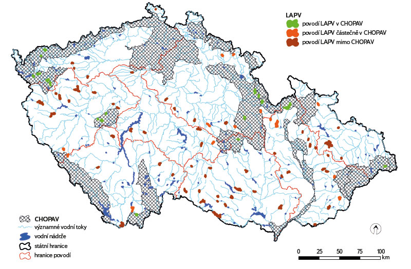
Fig. 3. CHOPAV areas in relation to basin sites for the accumulation of surface water
LAPV category A (whose importance for water management lies primarily in the ability to create or supplement sources for drinking water supply and possibly perform other functions, especially positive influence on the runoff conditions of large basins) as well as LAPV category B (which are suitable for flood protection, coverage of water abstraction requirements and improvement of discharge) are currently only protected to the extent of the future flooded area. The basins of these possible future reservoirs have no legislative protection resulting from the inclusion of the relevant LAPV in the General.
In the case of existing water reservoirs, the protection of their basins is ensured in the form of protection zones for vulnerable water resources. For the LAPV basins, there is currently no targeted protection. Therefore, CHOPAV could be a suitable tool for such protection. For this reason, we carried out a spatial analysis of the current condition, and in the map in Fig. 3, LAPVs are shown according to the protection of their basins due to the existence of CHOPAVs. We consider those whose entire basin falls within the CHOPAV to be the best protected, the second group are those where at least part of their basin in the spring area is protected. The third group consists of those that do not currently have any watershed protection. These sites, which are also found in larger groups, such as in Vysoina or in western Bohemia, give impetus to the expansion of an existing CHOPAV, or to the declaration of a new one.
Other legislative tools for comprehensive protection of the aquatic environment
There are other tools in the environmental protection system that can be used for general water protection. However, they are directed only to a specific activity. For example, the requirements of the Nitrate Directive [5] fall under agricultural management. It is an EU directive created to protect water from nitrate pollution from agriculture. According to its requirements, so-called vulnerable areas have been earmarked which already show an increased nitrate content in water and where stricter requirements for agricultural land management are applied. Compared to the long-declared and unchanged CHOPAV, these vulnerable areas are regularly updated according to monitoring results.
All surface waters in the Czech Republic were also defined as sensitive areas according to the Urban Waste Water Treatment Directive [6]. It aims to limit the entry of phosphorus into surface waters, which is especially important for existing and future water reservoirs.
Almost a third of the forests in the Czech Republic are forests of water management significance with specific water management functions. These are forests in protection zones for vulnerable water resources and forests in protected areas of natural water accumulation. Forests in mountain CHOPAV have a water protection, anti-erosion, infiltration, and drainage function with the same management as in protection zones for vulnerable water resources. However, if there is destruction of forest stands or salvage cutting, technical melioration – drainage – must be carried out on the resulting clearings in order to prepare favourable conditions for forest restoration. There is thus a conflict with the requirements of the Water Act, where for CHOPAV “… it is flatly prohibited to drain forest land“ [7].
The position of CHOPAV in the spatial planning process
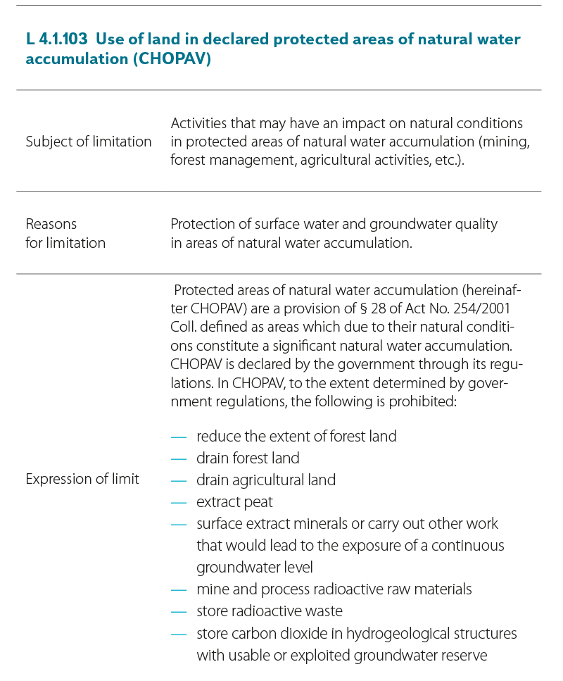
When proposing the use of land for certain functions and activities, it is necessary to deal with a number of prohibitions or restrictions resulting from various legal regulations. These prohibitions and restrictions enter the spatial planning activity as „Limits on land use.“ This means restrictions due to the protection of public interests, restrictions resulting from legal regulations, or from the characteristics of the area. Area limits are therefore not another legislative tool; on the contrary, in the form of area analytical documents [8], they summarize the legislative requirements for the given phenomenon in one document, and are thus an aid for those preparing spatial plans.
The Ministry for Regional Development issued Methodological Instructions [9], where it refers to „Limits of land use“, specifically to Limit No. 4.1.114 – Land use in declared CHOPAVs.
Part of this Limit is presented in Tab. 2.
Tab. 2. Limits and other requirements for land use, as of 1st July 2023
CHOPAV issues focused on groundwater
Geological structure of the CHOPAV areas in the Czech Republic
The geological structure of the Czech Republic is very complex due to the existence of two completely different units with completely different geological development. A certain degree of generalization is necessary for its description and subsequent work. The Hydroecological Information System (HEIS) was used for a simplified description of the geology in the CHOPAV areas:
- Carpathian flysch – Beskydy, Jablunkovsko, Vsetínské vrchy,
- Metamorphites and sediments of the culm – Jeseníky,
- Metamorphites – amberk – Králíky, Orlické hory, árské vrchy, Krkonoe, Kruné hory, umava,
- Quaternary sands, gravels – Quaternary of the Morava river,
- Cretaceous sandstones, claystones – Vchodoeská kída, Polická pánev, Severoeská kída,
- Acidic igneous rocks and volcanics, tertiary sediments – Jizerské hory, Chebská pánev and Slavkovsk les,
- Mafic igneous rocks and volcanics – Brdy,
- Tertiary sediments – Teboská pánev.
According to lithology, the aquifer rock environment that forms the subsoil of the CHOPAV area is vulnerable to pollution wherever overlying hydrogeological insulators, which could prevent it, are not developed. Precipitation infiltration occurs on the surfaces of hydrogeological collectors, while hydrogeological insulators prevent pollution in areas of drainage and groundwater accumulation. Basin structures which are Cretaceous formations and Tertiary sediments are well protected in the water accumulation areas by overlying insulators. Crystalline rocks are more vulnerable from the point of view of groundwater formation which, like CHOPAV, are protected from the point of view of surface water and, at the same time, form a subsidy (infiltration) background for basin structures. Examples include the Jeseníky Mountains and Quaternary of the Morava river (two adjacent CHOPAVs) and Chebská pánev (one CHOPAV).
Groundwater zones
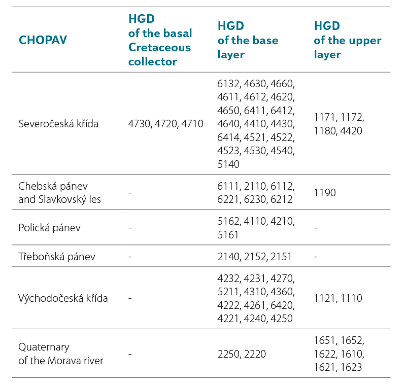
Groundwater zones were newly defined by Decree No. 5/2011 Coll., on the definition of groundwater zones and groundwater bodies, the method of assessing groundwater status and the requirements of programmes for the detection and assessment of groundwater status [10]. The groundwater zone is a basic balance unit and is „defined on the basis of natural characteristics, especially according to hydrogeological conditions, type of irrigation, and groundwater circulation“. If we compare the boundaries of CHOPAV (announced for groundwater in 1981) with the boundaries of groundwater zones, it is clear that they do not correspond in most cases (Fig. 4). Tab. 3 shows all the groundwater zones that, with their projected area, extend into the CHOPAV area declared for groundwater. The situation at Severoeská kída CHOPAV is the most complex; it includes three layers of hydrogeological zones – basal collector zones, base layer zones, and upper layer zones.
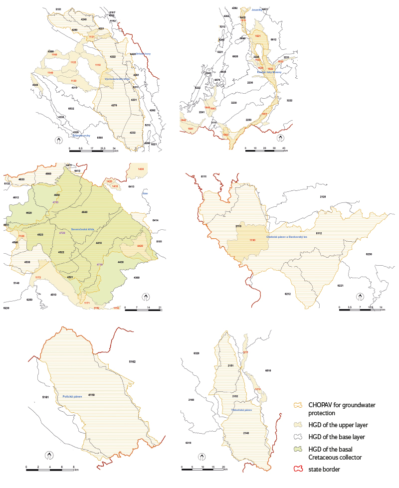
Fig. 4. CHOPAV areas in relation to groundwater zones
Tab. 3. Relationship between CHOPAV areas focused on groundwater and groundwater zones
The aim of CHOPAV is to limit activities that affect shallow groundwater circulation – reducing the infiltration capacity of precipitation (reducing the area of forest stands) or draining the landscape (land drainage); also, to eliminate interventions in aquifers that can lead to their damage – uncovering the groundwater level in the upper layer zones or mining of radioactive raw materials in basal collector zones.
Conflict of interests in practice – protection of groundwater versus gravel sand deposits
A significant conflict of interests is taking place in the Quaternary of the Morava river CHOPAV in the cadastre of Uhersk Ostroh, on the border of the South Moravian and Zlín regions. The Moravsk Písek – Uhersk Ostroh gravel-sand deposit is demarcated on the Uhersk Ostroh cadastre, the extraction of which would expose the free groundwater level. However, this should not happen within CHOPAV. At a distance of about 500 m from the boundary of the exclusive deposit, there is the boundary of the first stage protection zone of the Bzenec Water Resource – complex of receiving well III north. Simultaneously, the active zone of the floodplain runs through the exclusive deposit. Drinking water from the Bzenec Water Resource – complex supplies 140,000 inhabitants in southeastern Moravia. If the water from a flood penetrated into the exposed groundwater level, it would create a major problem for drinking water supply. A significant risk factor is the fact that, after the possible extraction of the gravel-sand deposit, the mining pit will have a groundwater level exposed even after the deposit restoration [11].
Approach to comprehensive landscape and water protection in neighbouring countries
In Slovakia, due to the common government in the past, 10 CHOPAV areas (chránené oblasti prirodzenej akumulácie vôd in Slovak) or protected water management areas (chránené vodohospodárské oblasti, CHVO) were declared by government decree, just as in the Czech Republic, in 1978 and 1987.
In contrast to the Czech Republic, the issue of CHVO areas in Slovakia has been unified and updated into one comprehensive approach for groundwater and surface water protection, namely in Act No. 305/2018 Coll. [12]. The aforementioned law is intended exclusively to protect the 10 most valuable areas in which the largest groundwater reserves are located. CHVO occupy 6,942 km2, which represents 14.16 % of the total area of Slovakia. The largest part of the CHVO area is occupied by forests, which make up 67 % of the area. As in the Czech Republic, large-scale water protection in Slovakia is separated from landscape protection in the form of a national park or protected landscape area; the difference lies only between the method of administration and management requirements in these areas.
Other neighbouring countries do not have large-scale water protection in the form of our CHOPAVs; water protection is managed in basins in accordance with the Water Framework Directive. It is also one of the components, not a priority, in landscape protection in national parks and other types of nature conservation.
In Poland, protected areas are defined by the Act of 16 April 2004 on nature conservation (Ustaw z dnia 16 kwietnia 2004 r. o ochronie przyrody). Protected areas are declared in ten categories, two of which are large-scale – national park (park narodowy – 23 in total) and protected landscape area (park krajobrazowy – 125 protected areas). On the border with the Czech Republic lies Karkonoski Park Narodowy (Karkonosze National Park) adjacent to the Czech Krkonoe National Park, Park Narodowy Gór Stoowych (Stoowe Mountains National Park), which is a continuation of the Czech Broumovsko Protected Landscape Area, and also nienicki Park Krajobrazowy (nienik Landscape Park) adjacent to the Czech Králick Snník mountain range.
There are a total of 16 national parks in Germany. Nationalpark Sächsische Schweiz (Saxon Switzerland National Park) is adjacent to the Czech border, adjoining Bohemian Switzerland National Park. Another border national park is Bayerischer Wald (Bavarian Forest), which together with umava National Park forms one of the largest bilateral national parks in Central Europe. According to data from the Federal Agency for Nature Conservation, at the end of 2008 there were 7,203 protected landscape areas in the Federal Republic of Germany, covering 9.9 million hectares. This corresponds to approximately 28 % of the area of Germany. In German Saxony and Bavaria, as federal states neighbouring the Czech side, the following can be named as protected areas: Zittau Mountains (Zittauer Gebirge), occupying the German part of the Lusatian Mountains; Saxon Switzerland (Sächsische Schweiz), followed by the Elbe Sandstone Protected Landscape Area; Bohemian Switzerland National Park; and Upper Bavarian Forest Nature Park (Naturpark Oberer Bayerischer Wald).
There are six national parks in Austria. The oldest park is Hohe Tauern National Park (Nationalpark Hohe Tauern), which was declared in 1981. Thayatal National Park is adjacent to Podyjí National Park on the Czech side. Other categories such as „protected landscape areas“ or „nature parks“ only exist in some federal states. In 2009, there were 247 areas with the status of a protected area in Austria with an area of 2,696 km (about 15 % of the country).
DISCUSSION
From a general point of view, CHOPAV is a very important tool for protecting the quantity and quality of surface water and groundwater where significant accumulations of these waters are created, which are used for water supply or potentially usable for water supply. The biggest legislative problem lies in the fact that, even though CHOPAV is included as an instrument of the Water Act (No. 254/2001 Coll., as amended), the individual areas were declared by Government Regulations No. 40/1978 Coll., No. 10/ 1979 Coll., No. 85/1981 Coll., within the previous Water Act No. 138/1973 Coll. This creates practical problems when requiring compliance with restrictive measures, including dealing with loss to landowners, etc.
There is an opinion (including the Ministry of the Environment) that where the area is protected, for example, in the form of a PLA, further protection is unnecessary. In practice, however, it appears that PLA administrations do not have the obligation and often do not even have the necessary expertise to comment on specific problems of protection, creation, and maintenance of conditions for natural water accumulation.
In this sense, CHOPAV appears to be a relatively weak legislative tool compared to the promotion of other interests, also due to the absence of an administrator of these areas. An example can be an important source of groundwater for supplying the population with drinking water – Bezová nad Svitavou catchment area. The water source itself, including the protection zones, is located within Vchodoeská kída CHOPAV and should be uniformly managed in this area. In the case of conflict of interests in this area, it will be dealt with by the owner or operator of the water resource, a municipal authority, a municipality with extended powers, a regional authority with the water rights agenda, or the Ministry of the Environment as the last resort, who is, by law, the central authority; otherwise, there is virtually no one to contact within the entire CHOPAV.
CHOPAVs were announced with the aim of protecting areas that are important for the creation of surface water and groundwater sources. Since their announcement, there has been a significant legislative change in the area division of groundwater in the Czech Republic – the definition of groundwater zones. These are the basic area unit from the point of view of assessing the condition of groundwater and providing the basis for the performance of public administration and spatial planning. In the case of CHOPAVs, it would be advisable to revise their boundaries and bring them into line with the boundaries of the groundwater zones, or to make the boundaries of CHOPAV superior to groups of groundwater zones, if CHOPAV also includes the subsidy background of the upper layer zone.
One could also argue that protection in the form of CHOPAV is unnecessary as it is not applied in the majority of neighbouring countries. The opposite can be presented, for example, in the area of the Ore Mountains. On the German or Czech side, no comprehensive method of nature conservation is applied; it is always only a matter of small areas protecting only a specific natural feature, etc. The Ore Mountains CHOPAV is thus the only comprehensive protection of this area valuable for water management and nature.
Proposals for changes and new approaches to CHOPAV
From the water protection point of view, CHOPAV is still of irreplaceable importance. However, updating is necessary, similar to the one in Slovakia in 2019. Each existing area should be re-evaluated with regard to the overall scope, and also the modification of the given prohibited activities in relation to today’s use of the area, nature conservation, and natural conditions.
Within the CHOPAV framework, it is forbidden to drain land. Due to the periods of drought, it would be advisable to eliminate the drainage on CHOPAV areas that occurred before they were announced, which would reduce water runoff from the landscape. For example, in umava PLA, which is also CHOPAV, these measures are already being implemented on peatland areas.
It would be appropriate to increase the legislative status of CHOPAV in relation to extraction of raw materials, which increases the risk of contamination of drinking water resources in the case of gravel sand extraction from groundwater.
The risk of connecting aquifers as a result of the implementation of boreholes for heat pumps, especially in chalk CHOPAVs, has appeared as a new problem. Boreholes for heat pumps that connect aquifers also represent a qualitative and quantitative risk for groundwater.
It is necessary to consider declaring some new areas with CHOPAV type protection. The first could be the floodplain and the spring area of the Odra river. Although part of the intended area is protected at least as Poodí PLA, it is not primarily focused on water protection. The forested water source area for the proposed Spálov water reservoir, which could be an important source of drinking water due to its volume, is not yet protected.
There are also spring areas in the Bohemian-Moravian Highlands that supply water to streams with probable future reservoirs. The protection of the relevant area could be a form of significant expansion of CHOPAV árské vrchy or the creation of a completely new area with this type of protection.
CONCLUSION
The analyses carried out show that protection of the area through CHOPAV is justified even at the present time. In some respects, such as the protection of the LAPV watershed or the protection of groundwater from insensitive gravel sand extraction, it plays an irreplaceable role. However, there would be a need to update and modernize the relevant government regulations with regard to new protection requirements resulting, among other things, from adapting to climate change. It is also necessary to consider the expansion of existing areas or even the declaration of new areas with this type of protection.
Acknowledgements
This article was created within the framework of the project „ADAPTAN II – Integrated approaches to the adaptation of the landscape of the Moravian-Silesian Region to climate change“ financed by the Technological Agency of the Czech Republic (Project registration number: 3204200006-EHP) and through the Norwegian Funds 2014-2021, Bergen call.
The Czech version of this article was peer-reviewed, the English version was translated from the Czech original by Environmental Translation Ltd.
