ABSTRACT
This article deals with applications of the specific method of multicriteria analysis (MCA) and its use in the identification of areas within the Czech Republic where adaptation measures to the consequences of climate change would be most effective. MCA was chosen due to its comprehensive approach and the simplicity of working with available data in the Czech Republic. The first MCA have already been applied in the Pilsen and Pardubice Regions within the framework of the creation of the strategic document Regional Strategy of Adaptation Measures (Regionální strategie adaptačních opatření, ReSAO), whose aim was to assess the vulnerability of the entire area of these regions. The results from both strategies are expedient from the point of view of drafting adaptation measures, and it was therefore decided to use MCA as part of a larger project in the Dyje basin. In the first phase, the implemented analyses were evaluated to improve MCA for the studied area. In the second phase, MCA was applied to the area of agricultural land. Several thematic indicators were evaluated, namely surface drainage, land use, erosion risk, and occurrence of erosion events. The aim was to focus on IV order basins, in which the priority of implementing measures on agricultural land is the highest. The result was a list of IV order basins with a partial and summary assessment of problems within the total studied area of the Dyje basin.
INTRODUCTION
The topic of adaptation measures has recently become very topical as a result of climatic and hydrological extremes (floods, drought). Approaches to finding optimal solutions differ as there is a lack of effective connection not only between the academic sphere and the actual measures’ investors, but also the wider public. Given the state of the Czech Republic’s landscape, which has been extensively altered by man in the past, as well as due to limited resources and work capacities, the key task is to identify areas where adaptation measures will be most effective.
Areas with a defined flood risk [1], areas of critical points [2], or areas defined from the sub-basin plan can be the basis for selecting the most endangered places; however, it is always an assessment of a partial issue. Due to the large amount of geospatial data describing the entire scope of the landscape of the Czech Republic, using multidisciplinary and multicriteria analysis, which would allow creating a synergistic overall view, seems ideal.
METHODOLOGY
Multicriteria analysis (MCA) is a set of systematic procedures for drafting, evaluating, and selecting alternatives, most often based on conflicting criteria. It is used in various fields, such as water management, e.g., within the MEDIATION (Methodology for Effective Decision-Making on Impacts and AdaptaTION) project [3], which focused on the evaluation of various approaches and methods (e.g., weighted average methods, pairwise comparison, or even more complex mathematical models), and identified MCA as the most optimal option for evaluating adaptation measures. Abroad, it was used, for example, as part of the BINGO case study [4], which, using MCA, evaluated the appropriateness of implementing adaptation measures in several selected countries (Germany, Cyprus, Portugal, the Netherlands, Norway, and Spain).
The basic starting points for the application of MCA in the Czech Republic are:
- use of existing data only,
- use of commonly known and simple operations,
- easy replicability,
- finding and validating new connections between used data.
As part of digitization, more and more information and data (raster and vector freely available data) are accessible worldwide which can be used in geospatial analyses. The advantage of using the mentioned methods is their easy replicability, which is primarily aimed at their use in other regions where MCA has not yet been implemented. Thanks to the individual analyses, as well as the feedback from the investors of the first two regional adaptation strategies, it will be possible to find new connections between the most frequently used environmental data. These new connections are the greatest added value of the presented research. The aim is to define such indicators that describe logical links within geospatial or landscape functioning in the broadest sense of the word. One of the specific examples is the application of MCA to one of the basic adaptation measures, namely to the seepage and transformation of surface runoff into underground runoff. The aim is to find an area with suitable soil and geological properties. However, it was often improperly drained in the past, and therefore no longer fulfils its natural function. However, on the basis of MCA, such suitable locations can be searched for both in floodplains, where similar drainage facilities are located, as well as in areas with a very gentle slope. Another example of the use of MCA is the effort to establish effective anti-flood measures, where MCA can help to find critical points in catchment areas and in areas with significant flood risk, manifested by intensive runoff from agricultural land and erosion events.
Multicriteria analysis in the Pardubice and Pilsen regions
For the first time, MCA was applied in this form during the development of the adaptation strategy of the Pardubice region [5] and then the Pilsen region [6]; the investors of both strategies were the relevant regional authorities. The starting point was the combination of geospatial data per unit of IV order basin. The MCA itself was divided into three main topics (problem, potential, need), while each topic had its own subtopic expressed by indicators. The problem expressed the difficulties of the area (e.g., flood risk), the potential expressed natural and social prerequisites for improvement, and the need expressed the demands of the socio-economic sphere on the area (water abstraction).The total number of indicators in the Pilsen region reached 135 and in the Pardubice region 97, although their exact enumeration is not the purpose of this article. Subtopics were related to soil, climatic drought, drought in watercourses, floods, land cover, watercourses, floodplains, human space, ecosystems, water abstractions, and water status.
The evaluation of individual indicators was added up; the basic criterion was the equal weight of all indicators. The assessment set up reflects the principles of the topics – i.e., the higher the assessment, the greater the problem, potential or need. Assessment of the problems as well as the potential and needs was established for each individual IV order basin.
After three or even two years, it can be concluded that this system has been successful. On the basis of the MCA, 20 priority areas were selected in the Pilsen Region, and in the Pardubice Region up to 24 priority areas were selected in several stages in which adaptation measures are currently being implemented. Since the MCA process was tested from its inception to implementation, it is possible to proceed to a critical evaluation of the analyses themselves and the data used for them.
Areas that have not yet received sufficient attention within the MCA include:
- The issue of drought and its impact on both the natural and socio-economic spheres, expressed, for example, by the number of localities reporting problems with water supply. The information of the integrated rescue system was not sufficiently used either, for example on visits to erosion events or floods from torrential rainfall.
- Another topic that would deserve more overall attention has been forests and their condition after the bark beetle outbreak has essentially ended, and the effect of other burdens, such as their drainage by buildings and mining technology.
- In both regions, the identification of social need, will, and demand for the implementation of measures was neglected, which is absolutely essential for the successful application of adaptation strategies. In the Pilsen region, a survey was conducted among municipalities, but its limit was the respondents‘ activity. Subsequently, the MCA for the Pardubice region was supplemented with a survey, where, according to published information, the response rate was approximately 25 %. Large reserves also lie in the possibilities of dealing with state land.
- These plots of land can be very well identified using data from the property cadastre. It goes without saying that the implementation of adaptation measures is in a national interest, if these measures are properly substantiated. However, it shows that the preparation and implementation of adaptation measures on state land is not easier.
One of the ways could be complex land improvements, but they are also not a universal solution to this problem. - In the Pardubice Region, the outputs of the HAMR project (Hydrology, Agronomy, Meteorology and Retention) [7], which is focused on the issue of drought, were also not used; however, they were subsequently used in the Pilsen Region.
- The aspect of the energy use of the landscape, which is topical especially with regard to the energy crisis, was also insufficiently evaluated. Indicators characterizing known alternative energy sources (i.e., wind and solar potential, geothermal potential, and the potential of water energy use) should be further incorporated into the adaptation strategies. However,
it is necessary to work with both the positive and negative impact of their use. It is necessary to monitor the effect of an increase in the number of solar farms on changes in runoff conditions, as well as the effect of the operation of hydroelectric power stations on the state of the relevant watercourses.
In conclusion, we can summarize that the use of MCA in the Pardubice and Pilsen regions has been successful. It showed that there is a lot of freely available background data in the Czech Republic. They have a different level of accuracy, timeliness and, above all, availability, however, after modifications and spatial homogenization, they can be successfully used in MCA. Thanks to these facts, there is a detailed manual for approximately 16 % of the area of the Czech Republic on which problem to deal with, and in which area.
Since countless indicators were evaluated in both strategies, not all connections have been described yet, nor has there been sufficient interpretation of the main conclusions of both strategies. Both regions therefore currently have an amount of data that should subsequently be applied to spatial planning documentation; however, with the exception of selected priority areas with specific draft measures, it has not yet been determined exactly how.
A clear contribution of MCA in both regions is the finding that intensively used agricultural land and river floodplains have the greatest potential for effective drafting of adaptation measures. It must be emphasized here that the delineation of river floodplains was very careful in both strategies.
Our project “Evaluation of the landscape water regime and revision of critical points as a basis for drafting adaptation measures and evaluation of their effectiveness using rainfall-runoff models”, implemented at the Institute of Landscape Water Management, University of Technology in Brno, is also based on the above-mentioned findings. It includes a wide range of topics and subtopics related to soil, climatic drought, drought in watercourses, floods, landscape cover, watercourses, floodplains, human space, ecosystems, water abstractions, and water status; compared to the MCA carried out in the Pilsen and Pardubice regions, the number of monitored indicators will be expanded. Of these, only indicators focused on agricultural land are presented below, where the topics of the primary production sector, landscape quality, and denudation forces such as soil erosion intersect, as well as measures to eliminate them. One of the most important and, simultaneously, the most problematic indicators is drainage of agricultural land. This issue is so topical that the elimination of the negative effects of drainage is one of the supported activities of the current OPE programme period. However, it is also a very controversial topic [8] which does not have a simple solution. On the basis of the MCA carried out as part of our project, it can be said that the rate of drainage of agricultural land in the Czech Republic is so great that it must have an effect on the water regime of the landscape. The MCA also showed that there are areas where the elimination of drainage would be a suitable type of adaptation measure. In addition, methodologies on how to deal with drainage have already been developed [9–11].
Application of multicriteria analysis to the Dyje basin
The validity of the above conclusions can be documented on the application of MCA in the Dyje basin, which extends into 11 order III basins (outside of the state border is not considered), located in a total of six regions (Tab. 1). The area was chosen in connection with the scope of Povodí Moravy State Enterprise, which has long been trying to improve the situation not only on watercourses, but also in the catchment area, in cooperation with other organizational components of state and public administration.
 Fig. 1. Map of studied area of Dyje river basin in Czech Republic
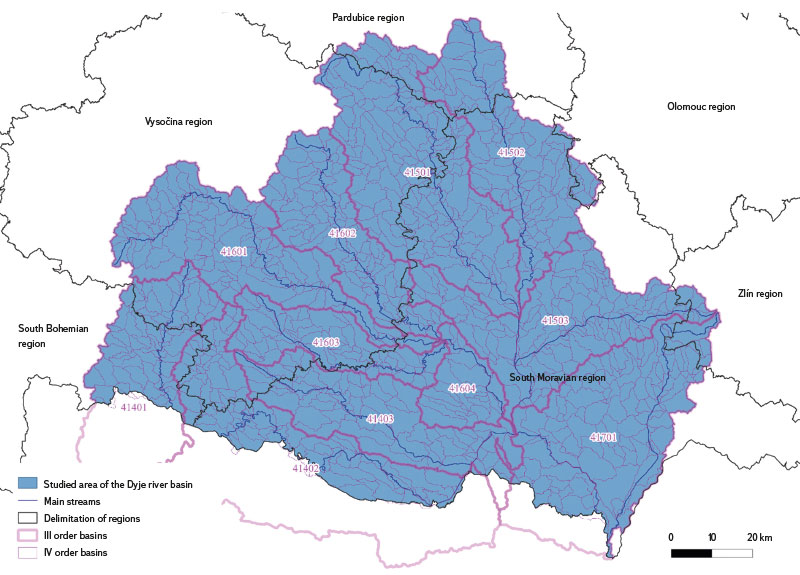
Tab. 1. III. Order basin in the area of interest
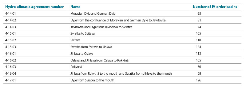
Fig. 2. River modification and the main reclamation facility in the area of interest
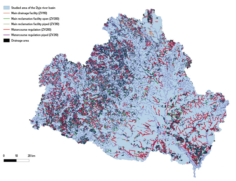
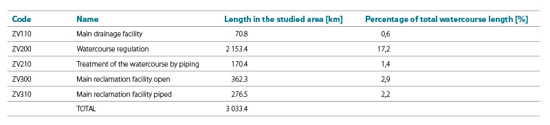
Tab. 2. Comparison of the length of various river modifications
As already mentioned above, MCA was applied in the studied area of the Dyje basin similarly to the above mentioned regional adaptation strategies, in the same form of three main topics (problem, potential, need) and subordinate subtopics, which are expressed by indicators. The evaluation of individual indicators was added up, with each indicator having the same weight.
The basic input data was: IV order basin layer [12], obtained from TGM WRI; layer of soil blocks (LPIS) [13] from the Ministry of Agriculture; data on drained and irrigated areas [14], from vectorized data of the Agricultural Water Management Administration, which is currently managed by the Ministry of Agriculture; and data of monitored erosion events [15]. All the mentioned background data were in shapefile format, which was used in all subsequent analyses related to the entire studied area of the Dyje basin as well as to individual IV order basins.
In the “problem” topic, agricultural land was evaluated according to the following indicators:
- Z1 extent of surface drainage,
- Z2 total length of reclamation channels in the basin,
- Z3 total length of watercourse regulation,
- Z4 extent of arable land,
- Z5 extent of soil blocks slightly at risk of erosion according to LPIS,
- Z6 extent of soil blocks strongly at risk of erosion according to LPIS,
- Z7 occurrence of erosion events.
For the purposes of MCA, individual indicators were given points, expressing the area or the total length of the catchment area. Specifically, by overlaying the layers in the ArcMap program (using the “Intersect” command), it was determined which area is located in a specific IV order basin. The given indicator was subsequently divided into categories on a scale of 0 to 5 points, where 0 = the indicator does not occur here either at all or only negligibly, and 5 = significant influence and occurrence of the indicator. In the case of indicator Z7, only two categories were created, namely 0 = the indicator does not occur here, 1 = the indicator occurs here. The resulting assessment was the sum of the values of the above-mentioned indicators (i.e., Ztotal = Z1 + Z2 + Z3 + Z4 + Z5 + Z6 + Z7). The highest value meant the greatest problem in the area of agricultural land. Data evaluation took place in the environment of geoinformation systems (ArcMap from ESRI and the open-source program QGIS), in which all map outputs were subsequently created.
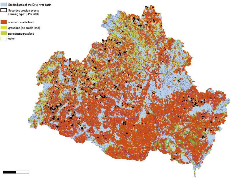
Fig. 3. Types of management on agricultural land
RESULTS AND DISCUSSION
According to the central register of watercourses, there are 12,527 km of watercourses in the studied area of the Dyje basin. From a historical point of view, the majority of watercourses in the landscape were under the management of the Agricultural Water Management Administration, namely 5,669 km of the length of watercourses and drainage facilities (approximately 45 % of the length of all watercourses in the studied area); after its operation ceased, responsibility for the condition of these watercourses were mainly taken over by Povodí Moravy State Enterprise, Lesy České republiky State Enterprise, and the State Land Office. The Agricultural Water Management Administration mainly carried out maintenance work on watercourses. This involved modifying riverbeds, dredging sediments, removing trees, mowing banks, etc.; however, under political and economic pressure, watercourses were also straightened, piped, agriculturally usable areas were drained, and possible restoration was suppressed. In 1983, adversarial proceedings of the technical and operational development plan of Povodí Moravy State Enterprise was held in Brno, which dealt with the issue of making adjustments to watercourses that meet the ecological conditions of the landscape in the given area, but without significant results. According to the analyses, almost 12 % of the total studied area of the Dyje basin was completely drained. From the point of view of modifications of watercourses and main reclamation facilities, approximately 3,000 km of their length was affected and modified, i.e., almost a quarter of all watercourses in the monitored basin. However, it must be taken into account that this data does not contain complete information about all watercourses and from all administrators, so it can be assumed that the total length can be significantly greater. Another factor affecting the currently existing documents is the shifting of responsibilities between institutions, both in terms of the transfer of physical project documentation and their electronic recording.
Area drainage was included in indicator Z1, which was subsequently related to the catchment area. The sum of the lengths ZV110 (main drainage facility), ZV300 (main melioration facility open), and ZV310 (main melioration facility piped) was included in the Z2 indicator, and the sum of the lengths ZV 200 (watercourse adjustment) and ZV210 (watercourse adjustment by piping) was included in the Z3 category.
Information from the public land register (LPIS) was included in the evaluation of indicators “Z4 extent of arable land”, “Z5 extent of MEO according to LPIS”, and “Z6 extent of SEO according to LPIS”. According to the public land register, 53 % of the total area is used as agricultural land, of which 43 % is standard arable land. Since 2014, there has been a decrease in standard arable land by about 80 km2, which is a negligible amount in terms of the total area.
Within the framework of the Agricultural Land Fund, the occurrence of recorded erosion events was also addressed, which were part of the indicator “Z7 extent of erosion events”. According to background data, 622 erosion events took place in the Dyje basin (on a total area of 80.7 km2), of which 99 % were on standard arable land. However, the quality of recording of erosion events is problematic. The almost 100 % occurrence of events on standard arable land can be affected by the subjectivity of recording, for example. The observer can better see furrows in arable land or in wide-row crops. Also, greater damage to roads occurs during erosion events on arable land without vegetation cover, especially during the period of soil preparation for sowing and within one month of sowing. It is also estimated that only 10 % of all erosion events are recorded in the erosion monitoring database, and even here a certain degree of subjectivization plays a role from the point of view of reporting, or the degree of citizen activity.
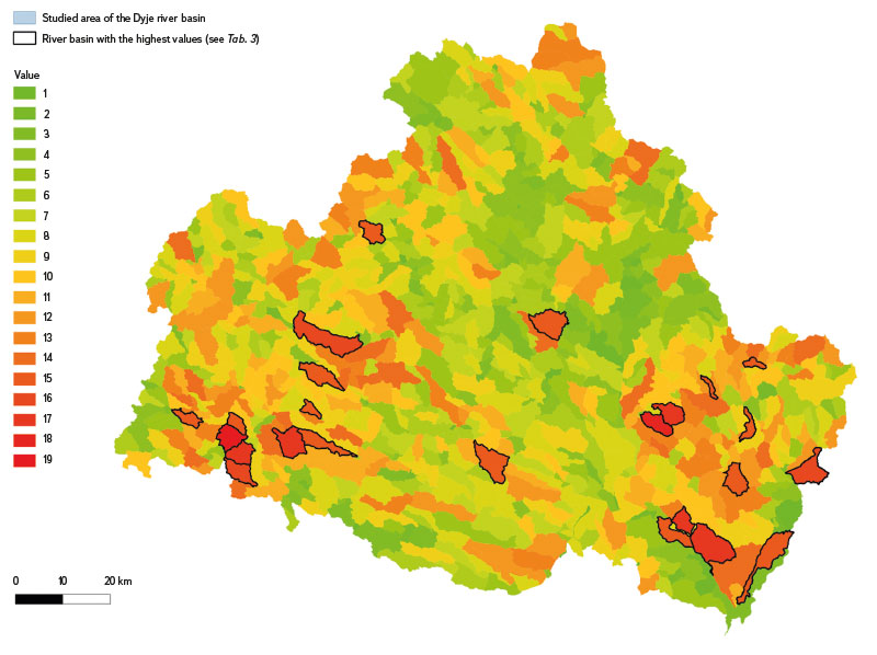
On the basis of the MCA methodology, a summary assessment regarding the area of agricultural land was created as a sum of partial indicators. 1,033 IV order basins were evaluated. The maximum value achieved in this area was 19, specifically in basin 414020280 (Ostrojkovický stream), west of the town of Jemnice in the Vysočina region, and the value 18 in basin 415031062 (Moutnický stream), east of the town of Židlochovice in the South Moravian region. The high level of threat of these basins is also evidenced by the fact that basin 414020280 was included in the study of semi-natural flood control measures in the Želetavka basin and in other critical basins above the Vranov water reservoir [16], whose investor was Povodí Moravy State Enterprise; in basin 414020280, the most extensive erosion event was recorded in the entire studied area. Tab. 3 shows an overview of IV order basins which reached the highest values in terms of the given indicators, namely values 15 and above.
Tab. 3. Final results of the indicators
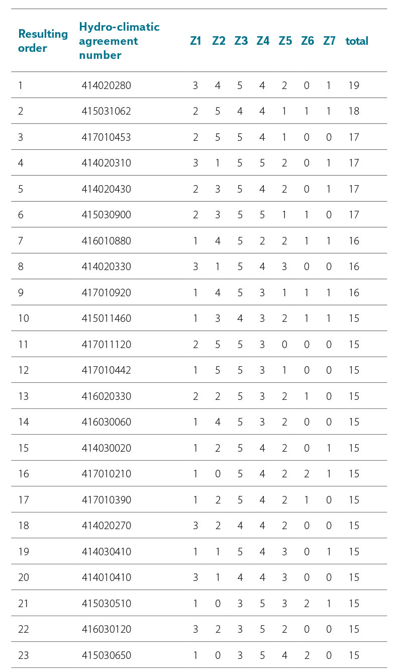
Fig. 4. Graphic representation of the indicators
CONCLUSION
MCA application is effective for the Czech Republic in terms of drafting adaptation measures. This is indicated by the results from both the Pardubice and Pilsen regions. The advantage of applying MCA in the Czech Republic is a large amount of background data which, although of varying accuracy, timeliness and, in particular, availability, can be used successfully after adjustments and above all after spatial homogenization. The biggest shortcoming in both regions proved to be the delay in identifying the social need and demand for the implementation of adaptation measures; it was proven that information about the possibility of implementing these measures should not only be directed to the representatives of cities and municipalities, but also to the wider public. As we already mentioned, the highly topical aspect of the energy use of the landscape was not evaluated within an MCA in the Pardubice or Pilsen region. The knowledge gained from both MCAs will be further taken into account when using MCA for the studied area of the Dyje basin, where an MCA related to agricultural land has already been carried out. An evaluation based on seven indicators, namely in the field of drainage of soil blocks (three indicators), their use, erosion risk (two indicators) and the occurrence of erosion events, was carried out in 1, 033 IV order river basins. Basin 414020280 (Ostojkovický stream) and basin 415031062 (Mutěnický stream) appear to be the most threatened within the MCA. In these basins, the priority of implementing adaptation measures on agricultural land is the highest.
The comprehensive MCA in the Dyje Basin will continue for the next three years, based on all the indicators used in the evaluation of both of the above-mentioned strategies, supplemented by an evaluation of the impact of the energy use of the landscape, the expansion of research in the area of forests, but also state land, and also with greater public involvement.
Acknowledgments
The research presented in this paper was supported by the specific junior grant FAST-J-22-8039 „Evaluation of the landscape water regime and revision of critical points as a basis for drafting adaptation measures and evaluation of their effectiveness using rainfall-runoff models“. I also thank my colleagues for their moral support and professional advice.
The Czech version of this article was peer-reviewed, the English version was translated from the Czech original by Environmental Translation Ltd.
