ABSTRACT
The aim of this article is to evaluate landscape retention capacity based on the use of soil protection technology at the chosen site and to compare selected hydropedological characteristics in the context of land management. Therefore, broken and intact soil samples are taken regularly and laboratory analyses are carried out. The chosen site is located in the Šardice cadastral area, Hodonín district, South Moravian region. At the chosen site it is possible to consider grass strips with one or more rows of trees as a possible agroforestry system, where temperature and humidity are measured continuously by TOMST TMS-4 moisture sensors. The results show that the way land is used and cultivated has an impact on hydropedological properties of the land. We can influence them both positively and negatively.
INTRODUCTION
Due to current climate change, where increasing average annual temperatures are leading to more frequent extremes such as torrential rainfall and longer periods of drought, great emphasis is placed on returning the landscape to its original state, or at least as close to this state as possible. Over the past few decades, our agricultural landscape has not been managed in an ideal way, and therefore it is necessary to pay attention to this issue, especially the design of protective and adaptation measures. Land is the most valuable natural resource that every country has, and it is also non-renewable [1].
In the Czech Republic, soil is mainly threatened by water and wind erosion [2]. The effect of water erosion on the soil is manifested by leaching of organic and mineral particles from the soil and the transport of sediments from eroded areas. Subsequently, when the terrain slope decreases, they are stored in places of accumulation [3]. Other negative effects include damage to built-up areas, siltation of watercourses and reservoirs, and penetration of residues from agrochemicals and hazardous substances into the aquatic environment.
With intensive agricultural production on arable land and livestock production, it is possible to achieve high yields per unit of area and work, but they can negatively affect the environment. The design and implementation of agroforestry systems can be a contribution to mitigating climate change, improving landscape water management, supporting landscape biodiversity, and also creating a friendlier environment for humans.
The aim of this article is to evaluate the influence of agroforestry systems, the method of cultivation, and land use on the complex of soil hydropedological properties and the flow of moisture.
METHODOLOGY
Agroforestry system and its effect on the landscape
Agroforestry takes advantage of the combination of trees, shrubs, and livestock and their interaction. Agricultural and forestry technologies are both used. Agroforestry systems (AFS) use trees and shrubs in a targeted manner in agriculture, or possibly use forest products other than wood [4].
There are several definitions of agroforestry according to the time and place of origin. Despite many partial ambiguities in its definition, common guidelines for all agroforestry systems are the following:
- economic activity including both agricultural production and that provided by trees or shrubs,
- interconnectedness between these sub-components of the systems,
- emphasis on other non-production functions, or persistence of the system,
- the importance of the human role in the system.
There are a number of agroforestry systems. The methodology according to Dupraz et al. was used for basic classification of agroforestry and the European Agroforestry Federation EURAF. Using it, it is possible to define the basic categories of agroforestry on agricultural land [5]:
Agrisilvicultural – cultivation of woody plants on arable land, agricultural-forestry system, including woody plants and agricultural crops on the same plot of land. Some commonly used agrisilvicultural systems are thus made up of cultivated lanes and hedges (Fig. 1 and 2).
Silvopastoral – cultivation of woody plants on permanent grasslands, grazing-forestry system, grazing, animals grazing grass in AFS (Fig. 3).
Agrosilvopastoral – Agricultural-grazing-forestry system – i.e., cultivation of crops and trees combined with animal breeding.
AFS has the potential to be a tool for combining climate change, protecting people and property, and creating the foundations for a more sustainable economy and for social development. Sustainable forest management provides a framework for planning at international and national levels and is one way to address an ever-changing climate. At the same time, AFS has the potential to contribute to the field of adaptation strategies. These support sustainable management and community practices and have the potential not only to protect land and people from the adverse effects of climate change, but also provide an opportunity for greater and more sustainable rural development. These systems offer farmers opportunities in production diversity, risk reduction in farming (production), food security, and much-needed income generation. Further on, they can satisfy the commercial need for wood and improve environmental conditions. Thanks to agroforestry measures, a large number of trees are now harvested outside conventional forest plots [6].
 Fig. 1. Research area of INRAE, Restinclieres – a hybrid of royal walnut and black walnut in combination with an agricultural crop (Photo: V. Horáková)
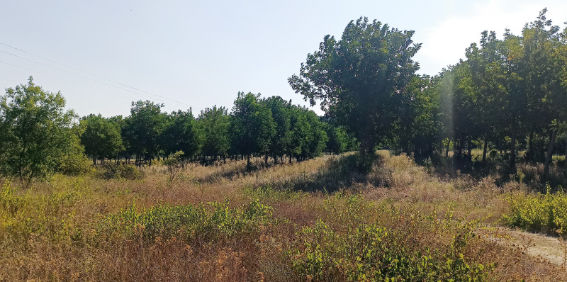
Fig. 2. Research area of the INRAE, Restinclieres – pines in combination with vines (Photo: V. Horáková)
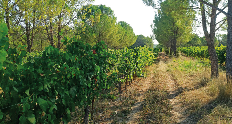
Fig. 3. Silvopastoral system – La Losse farm sheep breeding (Photo: V. Horáková)
The interaction between trees and crops can be studied in positive, negative, and neutral way. These interactions are dependent on the type of model used involving different variants of species, their nature, and arrangement. The interaction is further defined as the influence of one part of the system on the behaviour of another part of the system and/or the entire system [7]. Various interactions occur between trees and plants (crops and pastures). Studying the interaction between trees and crops within agroforestry could help find appropriate ways to increase overall soil productivity. The main positive effects of interaction are increased productivity, better soil fertility, nutrient cycling, and soil protection. The main negative effect of interaction is their competition, which reduces crop yields. This can be due to the space, light, nutrients, and moisture they need. The ecological sustainability and success of any agroforestry system is dependent on the interaction and complementarity between positive and negative effects. An agroforestry system can bring an overall positive result only when positive effects outweigh negative ones [8].
Soil properties in agroforestry systems depend on tree species and their intermingling, management practices, arrangement, quantity and quality of litter, and its rate of decomposition. Trees are planted in rows parallel to arable land with crops. These trees provide food, wood, fuel, fodder, building materials, raw materials for small forestry enterprises, and in some cases enrich the soil with essential nutrients [9].
Planting trees and their sustainability can help protect soil against the adverse effects of torrential rainfall. In addition, agroforestry systems can be used to recultivate degraded land and maintain water quality by capturing sediments, nutrients, and toxic substances. They also have the potential to move water from significantly deeper layers where water is found to layers that are drier and in a higher soil profile. This process has been described both in naturally occurring compositions of trees and grasses and in agroforestry systems [10].
In general, unprotected soil receives more sunlight than protected soil, and temperature follows the same trend. Many studies have shown that agroforestry systems perform better than a stand-alone cropping system in areas where there is either a shortage of groundwater or less atmospheric precipitation. Agroforestry is a good tool for crops that like shade and lower temperatures. Trees bring favourable changes in microclimatic conditions due to the influence of radiation flow, air temperature, wind speed, and saturation deficit of supplementary crops, which can have a significant impact on modifying the rate and duration of photosynthesis and subsequent plant growth, transpiration, and soil water use [11]. The shade of trees plays an important role in reducing evapotranspiration, reducing temperature, and increasing humidity. By removing trees, soil temperature can increase by about 4 °C and the relative humidity of the air can decrease by about 12 % up to 2 m above the ground [12].
Research site
As part of complex land improvements in the plan of common facilities (in addition to the design of the field/farm track network) in the Šardice cadastral area, anti-flood and anti-erosion measures were proposed in connection with the territorial system of ecological stability. As part of these multifunctional measures, in five locations – in order to adjust erosion and runoff conditions – ecological balance was achieved and various types of degradation of agriculturally used land were mitigated. Among the measures applied within the plan of common facilities are organizational measures (i.e., optimal delimitation of land types), protective grassing on erosion-prone locations, anti-erosion distribution of crops on slopes, belt rotation of crops, and anti-erosion distribution of crops. As part of the agrotechnical measures, there was sowing in a protective crop, stubble, mulch or post-harvest residues, grassing the erosion-threatened intermediate rows in orchards and vineyards in order to retain rainwater on the soil surface, and contour cultivation. The key proposed part are biotechnical and technical measures such as anti-erosion overhangs and boundaries, waterlogging strips, and stabilization of the paths of concentrated surface runoff by means of grassing the thalwegs. As part of the KPÚ (Krajský pozemkový úřad, Regional Land Office), four catchment anti-flood reservoirs and a system of field/farm tracks were also created.
Fig. 4. View of the agroforestry systems research site, September 9/2022 (Photo: V. Horáková)
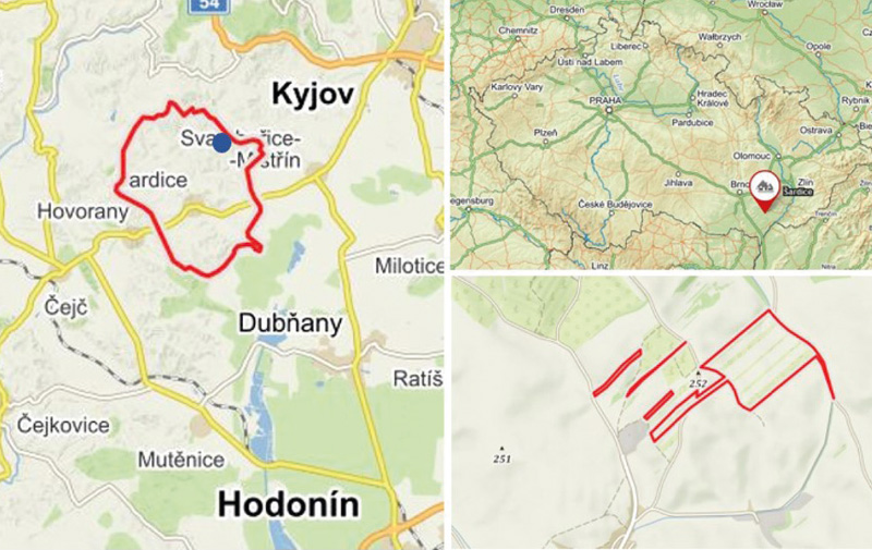
The research site is located in the Czech Republic in the South Moravian region, Hodonín district, Šardice cadastral area (Fig. 4). Due to the extensive nature of the measures and the size of the studied area, one specific site with implemented agroforestry systems was selected, which is located north to northeast of the village of Šardice (indicated by a blue dot in Fig. 4). The model site includes a system of buffer grass strips with linear planting of trees alternating with strips of agricultural crops (Fig. 5). The studied site falls into a warm and low-rainfall climate region.
Fig. 5. Comprehensive map and detail of the location of interest (Source: mapy.cz)
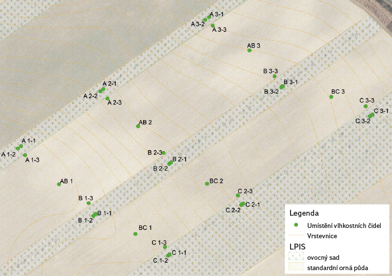
Between 2020 and 2022, the following aspects were monitored: soil physical properties, soil moisture, and soil temperature. Fig. 6 shows the location of individual humidity sensors and the locations of sampling for laboratory analyses. Broken (granular analysis) and intact (physical soil properties and hydrolimits) soil samples were taken. Placement and sampling were carried out at two depths, namely 20 cm (topsoil layer) and 50 cm (sub-soil layer).
Fig. 6. Location of humidity sensors and sampling points (Photo: V. Horáková)
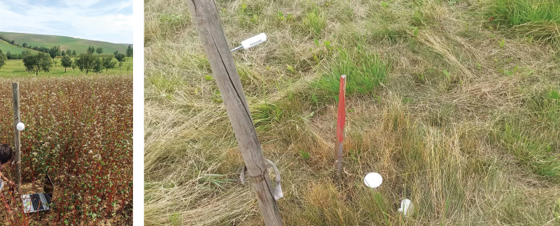
Humidity sensor reading takes place in the field (Fig. 7) by connecting the humidity sensor and the laptop using the cable with the reading device, which is supplied with the humidity sensors.
Fig. 7. Reading sensors in the field: in the middle of arable land (left), grass strip between trees (right) (Photo: V. Horáková)
RESULTS AND DISCUSSION
Due to the large amount of data, only a part of the results was selected, namely humidity with precipitation for the period 03/2021–11/2021, a comparison of humidity in strip a with respect to the position at depths of 20 and 50 cm, i.e. between trees (1), near a tree (2) and at the edge of arable land (3). The first number in the marking indicates the position on the slope, i.e. 1 = top, 2 = in the middle, and 3 = bottom; the second number in the marking is the location within the position on the slope (see the previous sentence). Furthermore, a comparison of the physical properties from strip A, from the first (4/2020) and the last (4/2022) spring collection, will be presented.
In Fig. 8, 10, and 12 (which are graphs for a depth of 20 cm) it can be seen that there is a rapid increase in soil moisture after rainfall. In the period without precipitation it is then reduced. The values for a depth of 20 cm range from 0.1–0.55 (i.e., 10–55 %), depending on the intensity and amount of precipitation. At a depth of 50 cm (Fig. 9, 11, and 13), soil moisture is quite balanced throughout the period and there are no sudden changes depending on the current precipitation; the values range from 0.05 to 0.4 (i.e., 5–40 %). Compared to a depth of 20 cm, the values are lower, but more balanced. The exceptions are two positions, namely a 3–2 (the lower part of the slope near the tree – Fig. 11) and a 3–3 (the lower part of the slope, the edge of arable land – Fig. 13). This jump increase can be explained by their location on the slope. Both positions are located in the lower part, which means that there is surface runoff within this area, and in this place the water is retained and absorbed to a greater extent.
Fig. 8. Precipitation and moisture course of the position between the trees belt A, depth 20 cm, period 03–11/2021
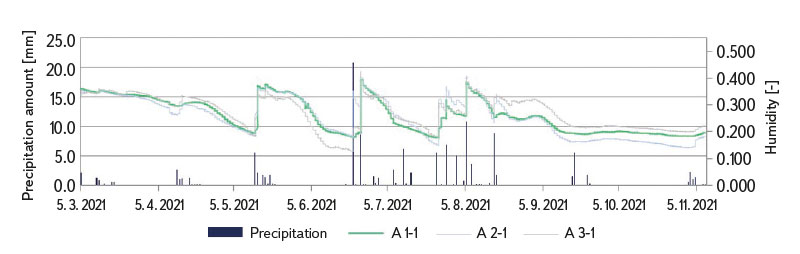
Fig. 9. Precipitation and moisture course of the position between the trees belt A, depth 50 cm, period 03–11/2021
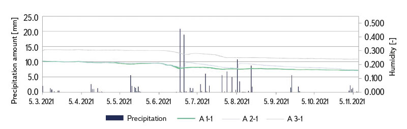
Fig. 10. Precipitation and moisture course of the position near the tree, belt A, depth 20 cm, period 03–11/2021
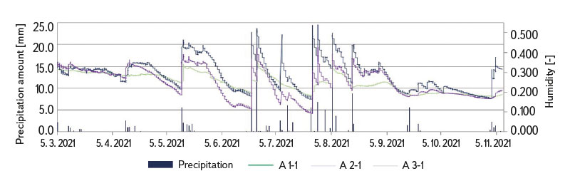
Fig. 11. Precipitation and moisture course of the position near the tree, belt A,
depth 50 cm, period 03–11/2021
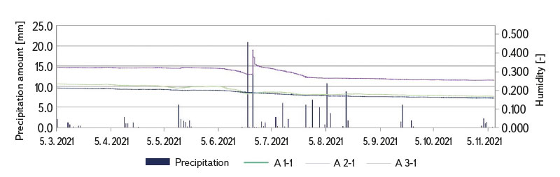
Fig. 12. Precipitation and moisture course position edge of arable land zone A, depth 20 cm, period 03–11/2021
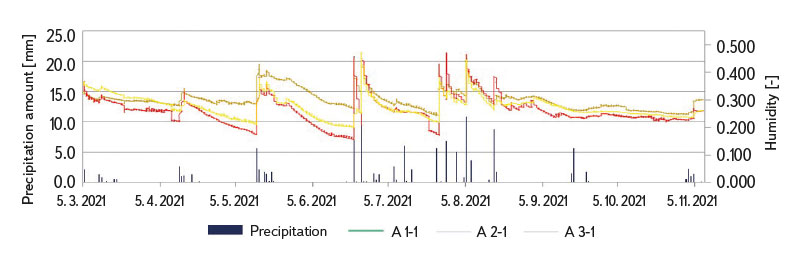
Fig. 13. Precipitation and moisture course position edge of arable land zone A, depth 50 cm, period 03–11/2021
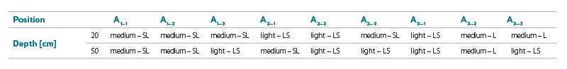
Between 2020 and 2022, broken and intact soil samples were taken, which were subjected to relevant analyses in the pedological laboratory of the Institute of Landscape Water Management of the Faculty of Civil Engineering, Brno University of Technology. The granularity of broken soil samples was determined by grain size analysis using the densitometric method according to Cassagrande. According to Novák, the samples were then classified (Tab. 1) as either light – loamy sand (LS), medium – sandy loam (SL), or loam (L) soil. Limit values for physical properties and hydrolimits are then determined on the basis of grain size analysis (see below in the text).
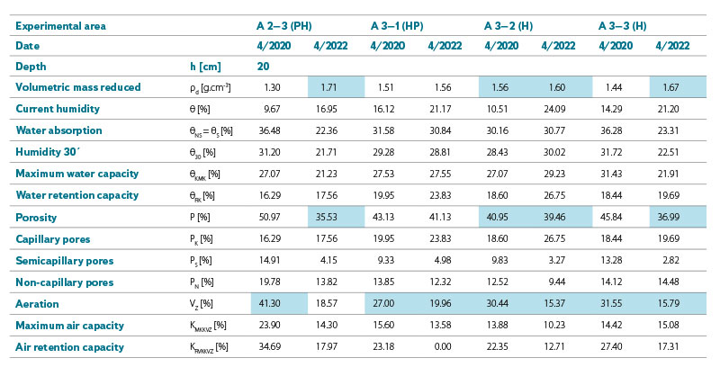
Selected physical properties and hydrolimits were evaluated from intact soil samples. The results from April 2020 and 2022 were selected for the example. Changes in the evaluated parameters are visible from them (Tab. 2 and 3 – depth 20 cm, Tab. 4 and 5 – depth 50 cm). Below the tables, the individual evaluated parameters are described and explained.
Tab. 1. Classification of granularity according to Novák
Tab. 2. Comparison of physical characteristics for belt A, depth 20 cm for the period 4/2020 and 4/2022 – Part 1
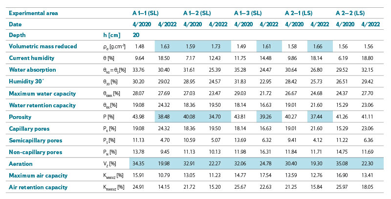
Tab. 3. Comparison of physical characteristics for strip A, depth 20 cm for the period 4/2020 and 4/2022 – Part 2
Tab. 4. Comparison of physical characteristics for strip A, depth 50 cm for the period 4/2020 and 4/2022 – Part 1
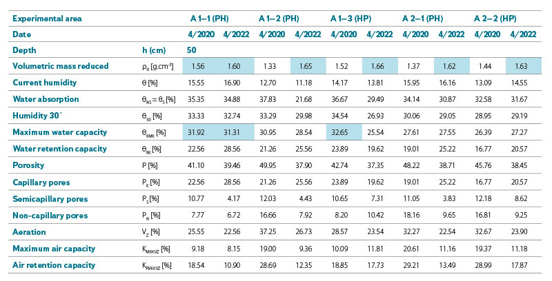
Tab. 5. Comparison of physical characteristics for strip A, depth 50 cm for the period 4/2020 and 4/2022 – Part 2
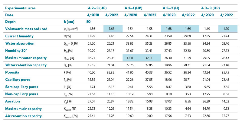
Critical volumetric mass (ρd) after drying according to Lhotský is: for loamy sand soil > 1.6 g.cm-3, for sandy loam soil > 1.55 g.cm-3 and for loam soil > 1.45 g.cm-3.
Minimum value of volumetric mass to limit root growth is: for loamy sand soil 1.8 g.cm-3, for sandy loam soil 1.75 g.cm-3 , and for loam soil 1.7 g.cm-3. No sample exceeded this value, which means that there is no limitation of root growth.
Current humidity (θ) indicates the current water content in the soil, expressing the ratio of the volume of water in the sample Vw to the intact volume Vs. Soil moisture changes throughout the year and is dependent on precipitation, evaporation, plant consumption, runoff, and groundwater seepage.
Water absorption (θNS = θS) is the condition when all pores are filled with water. This is effectively a condition that occurs immediately after rain.
Humidity 30’ (θ30) expresses how much water the soil is able to hold after 30 minutes of suction with filter paper from an initially fully saturated sample.
The maximum water capacity (θKMK) should not exceed the value of 31 % for loamy sand soils in topsoil and 30 % in subsoil, 35 % for sandy loam soils in topsoil and 31 % in subsoil, and 36 % for loam soils in topsoil and 34 % in subsoil; if it exceeds this value, it means that the water will not soak into the soil well. At a depth of 20 cm, the value was not exceeded for any of the samples. At a depth of 50 cm the situation was different and several samples exceeded this value.
The water retention capacity (θRK) expresses the maximum amount of water that the soil can retain by capillary forces after 24 hours of suction from the originally fully saturated soil.
Porosity (P) has a decisive influence on soil fertility, the existence of soil microorganisms, it allows the penetration of roots, water, and air into the soil and their movement in the soil. It increases with increasing humidity and, conversely, decreases with drying. In topsoil, it usually ranges from 40 to 60 % by volume and decreases with increasing depth. The critical value of porosity according to Lhotský is < 40 % for loamy sand soil, < 42 % for loamy sand soil, and < 45 % for loam soil.
Aeration (VZ) ranges between 18–24 % vol in topsoil horizons in good condition and 9–12 % vol in meadows. The aeration value must not fall below 10 % vol in arable soil and below 6 % vol in meadows, otherwise air exchange stops and anaerobic processes begin to take place in the soil. In such a case, an agrotechnical intervention must be carried out to increase the amount of air in the soil. No sample exceeded the threshold value, but the vast majority of samples were not in the optimal range that indicates a good condition of the topsoil horizon, which implies that the soil is not in good condition.
Values that do not meet the above critical values in Tab. 2–5 are highlighted in orange and values outside the optimal range are highlighted in grey.
CONCLUSION
Research has been ongoing since 2020, and every year data is collected both from moisture sensors, which measure continuously, and from regular collection of intact soil samples at the beginning and end of the growing season. The data obtained from the moisture sensors will be subjected to statistical analysis, which will examine and compare whether and to what extent slope position, habitat location (arable land, grass strip), season, and amount of precipitation affect change in humidity (at both depths).
The above data show that slope position (slope of the land) and the way the land is used has an influence on the course of moisture and resulting physical parameters of the soil. For the selected periods of 4/2020 and 4/2022, the best values are at a depth of 20 cm for the position A 2–2 (in the middle of the slope near the tree) and a 3–1 (the lower part of the slope between the trees), both from the point of view of the course of humidity, as well as in terms of physical parameters. For both positions, only the aeration value is not satisfactory; it is outside the optimal value for a topsoil horizon in good condition. However, when comparing results from the first sampling with the last one, values for the positions in the grass strip with trees worsened. On the other hand, for arable land, the values are rather balanced, without major fluctuations.
The final evaluation of agroforestry systems shows that they cannot avert ongoing climate change, but they can help mitigate negative impacts on the landscape, especially by mitigating erosion (both wind and water) and by retaining precipitation in the landscape, i.e., by increasing infiltration and reducing direct surface runoff, which is important due to the volatility of rainfall (long periods without rainfall or torrential rainfall). Overall, it can be concluded that the landscape is returning to a better appearance and wildlife is also returning to it.
The research is still ongoing and will be expanded by experiments using a deep aeration device, which should help in aerating the soil horizon at the required depth, thereby improving the infiltration capacity of the soil. Both broken and intact soil samples will be taken at the experimental sites before and after the intervention for laboratory analysis, so that the effect on hydropedological properties of the soil can be evaluated. Furthermore, a soil sample will be taken for analysis of edaphon (i.e. animals and organisms living in the soil) in order to assess whether and what effect this intervention has on them.
Acknowledgements
Supported by the Technological Agency of the Czech Republic, project No. TH04030409 – “Agroforestry systems for the protection and restoration of landscape functions threatened by the impact of climate change and human activity” and the Grant Agency of the Czech Republic, project No. BD122001010 – “Evaluation of the water regime of the landscape and revision of critical points as a basis for the draft adaptation measures and evaluation of their effectiveness using rainfall-runoff models”.
The Czech version of this article was peer-reviewed, the English version was translated from the Czech original by Environmental Translation Ltd.
