ABSTRACT
This article presents landscape changes in the upper part of the Výrovka river basin using a comparison of historical and current maps and orthophotomaps, including verification of the current state of the landscape. On the map of the 2nd Military Mapping, 22 water bodies (ponds) with a total area of 57.53 ha were mapped. On the current map, 71 water bodies with a total area of 42.48 ha were recorded. Furthermore, significant changes in the location of watercourses were recorded; they were deepened, straightened, and their floodplains were drained. It is clear from the comparison of the map documents that these changes mainly occurred due to the intensification of agricultural use of the landscape.
INTRODUCTION
The aim of this article is to provide information on the site that is being analysed within the framework of systematic research in Polabí lowland. One of the main objectives of this research was to map landscape changes at sites of current and disappeared ponds and wetlands, as well as changes in the location of watercourses in the catchments of the tributaries of the Elbe in Polabí lowland. The research was based on the interpretation of archival maps and their comparison with contemporary sources, including field surveys at the respective sites. Particular consideration was given to the possibility of restoring water retention features at suitable locations in this landscape. Specifically, this article describes changes in the location of watercourse channels and the development of the pond system on the Výrovka, i.e. in the intercatchment of the water body “Výrovka from the source to Ostašovský stream, inclusive”. Polabí lowland is currently experiencing a significant groundwater deficit, and small watercourses are increasingly subject to seasonal drying, not only in summer but also in spring and autumn. In most cases, these are straightened, paved and deepened watercourses with degraded floodplains. In connection with the expected continued occurrence of extreme climatic events, it would be desirable to focus attention on the restoration of landscape elements with a positive influence on the water regime in the landscape, as well as on water management in the landscape as such.
SITE DESCRIPTION
Hydrology
The study area is defined by the intercatchment of the surface water body HSL_2620 Výrovka from the source to Ostašovský stream, inclusive, covering an area of 57.364 km². This water body, or rather its intercatchment, belongs to the third-order catchment 1-04-06 Výrovka and is located on the watershed of the sub-catchments of Upper and Middle Elbe and Lower Vltava within the international Elbe River Basin (Fig. 1). The Výrovka rises in Kochánov at an elevation of 492.5 m a. s. l. The total length of this watercourse is 61.9 km, and it is a left-bank tributary of the Elbe near the village of Písty in Nymburk district at an elevation of 181 m a.s.l. From the surface water body HSL_2620 Výrovka from the source to Ostašovský stream, inclusive, the stream flows into, or rather through, Vavřinecký pond at river kilometre 52.7, i.e. 19.2 km from the source. According to the Strahler stream order system, the river Výrovka is of the fifth order here [1–3].
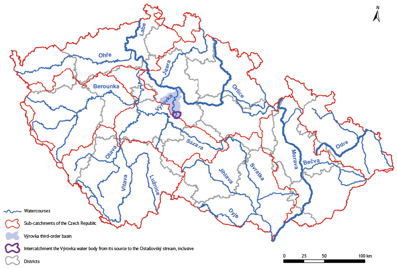
Fig. 1. The study area in the context of hydrological and administrative divisions
Administrative divisions
From an administrative perspective, the intercatchment of the water body is located in Central Bohemian Region (Fig. 1) predominantly within Kutná Hora District (cadastral areas Bláto, Chmeliště, Janovická Lhota, Jindice, Kochánov u Mitrova, Křečovice u Onomyšle, Mančice u Rašovic, Miletín u Onomyšle, Mitrov u Uhlířských Janovic, Nepoměřice, Onomyšl, Opatovice II, Rašovice u Uhlířských Janovic, Rozkoš u Onomyšle, Staňkovice u Uhlířských Janovic, Sudějov, Uhlířské Janovice, Vavřinec, Žandov, Žíšov, and tiny parts of cadastral areas Smilovice u Staňkovic and Staré Nespeřice), and to a small extent in Kolín District (cadastral areas Církvice u Kolína, and Skvrňov) [2, 3]. The water body itself flows through cadastral areas Kochánov u Mitrova, Janovická Lhota, Uhlířské Janovice, Chmeliště, Žíšov, and Vavřinec (Figs. 2 and 3).
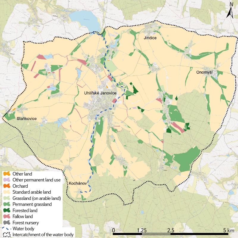
Fig. 2. Land use according to LPIS 2023 in the intercatchment of the Výrovka water body basin from the spring to the Ostašovský stream including in the context of BTM 10 (2024)
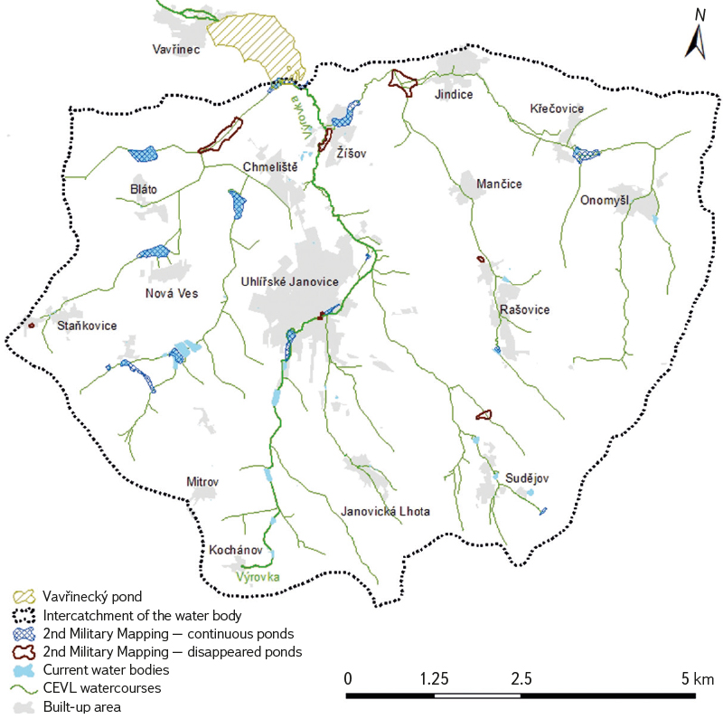
Fig. 3. Landscape changes from a water-management perspective in the intercatchment of the Výrovka water body basin (from the spring to the Ostašovský stream), from the 2nd Military Mapping (1852) to the present in the context of BTM 10 (2024)
Geology and pedology
From a geological perspective, the entire area of this intercatchment belongs to the Bohemian Massif. The geological bedrock consists almost exclusively of paragneisses and migmatites of the Kutná Hora crystalline complex. In the northern part of the studied catchment above Vavřinecký pond, gravels, sands, conglomerates and sandstones occur [3].
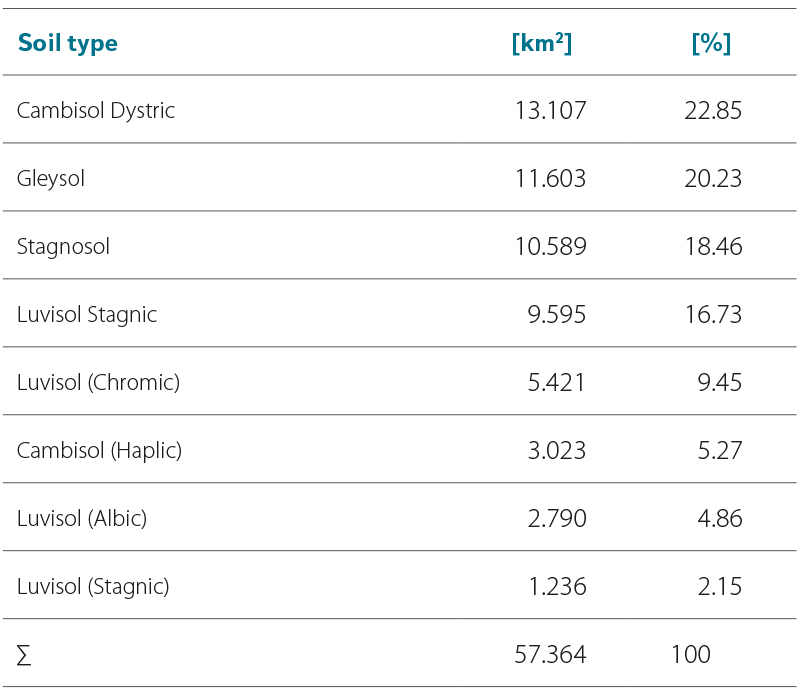
Soil conditions in the entire catchment are heterogeneous, with eight soil types occurring in the area (Tab. 1). In the immediate vicinity of watercourses, Gleyosols (with a pronounced redoximorphic features gleyic properties resulting from long-term saturation caused by a high groundwater table), Stagnosols (with a pronounced mottling and redoximorphic features caused by alternating waterlogging and drying of the soil profile), and Luvisols Stagnic or Haplic (soils with the presence of a luvic horizon with dark argillans) occur.
In the wider catchment area, these are mainly Cambisols (soils that develop predominantly under sloping conditions and are highly variable in their properties) and, to a lesser extent, Luvisols Chromic (soils with a profile differentiated by a slightly lightened eluvial horizon) [2–5].
Tab. 1. Soil types in the intercatchment area
Typology of the contemporary landscape of the Czech Republic
A total of four types according to the Typology of the contemporary landscape of the Czech Republic occur within the intercatchment. Two basic types of natural landscapes can be found here. The Výrovka source area belongs to the moderately cool landscape of uplands and highlands, while the remaining areas are located in the moderately warm landscape of basins and uplands. Two types of functional landscapes also occur. The Výrovka source area lies in a forest–agricultural landscape, while the remaining part of the intercatchment is situated in an agricultural landscape [6].
Land cover
From the perspective of land cover, a number of classifications with varying levels of precision or generalisation can be used. In this area, LPIS, CORINE Land Cover (CLC), and ZABAGED® are applied. In LPIS, only agriculturally used areas on which farming entities receive subsidies are recorded [7]. As a result, the LPIS register does not cover the entire area of the intercatchment. In this case, it covers 3,644.56 ha (63.53 %). Within LPIS, the clearly predominant land use category is standard arable land (86.25 %), while 10.62 % consists of permanent grassland; the remaining land cover categories recorded within LPIS are entirely negligible (Fig. 2).
According to the CLC classification, which is considerably more generalised compared with the classifications mentioned above [8], the dominant class is non-irrigated arable land, covering 64.36 % of the intercatchment area. Other classes with a more significant share are coniferous forests (18.09 %), land principally occupied by agriculture with significant areas of natural vegetation (8.22 %), and discontinuous urban fabric (4.29 % of the area). Other classes (pastures, transitional woodland–shrub, mixed forests, and industrial or commercial units) occupy only a very small proportion of the area. Water bodies occur on only 0.03 % of the intercatchment area and, due to the generalisation of this land cover type, only Vavřinecký pond is classified as a water body; however, it extends into the study area only by a very small part [3] (Figs. 2 and 3).
In the studied intercatchment, according to ZABAGED® [9], the dominant type is arable land and other areas – 3,390.48 ha (59.10 %). Other significant types include forest land with trees – 1,273.47 ha (22.20 %) and permanent grassland – 549.49 ha (9.58 %). A smaller share is formed by orchards and gardens – 234.83 ha (4.09 %) and settlement areas – 108.58 ha (1.90 %). Water bodies occupy only 0.81 % of this catchment. Shrub vegetation is represented only minimally (0.40 %), while marshes and swamps occurring on permanent grassland or forest land with trees are extremely rare (0.04 % and 0.05 %, respectively).
METHODOLOGY
The methodology used here is similar to that applied in other previously analysed sites in Polabí lowland and is described in greater detail, for example, in the article dealing with the development of the pond system on the Bečvárka [10]. The research was based on the selection and subsequent comparison of the present and historical state of ponds and watercourses in the intercatchment of this water body, based on the interpretation of contemporary and archival maps and orthophotomaps. This was followed by verification of the current landscape conditions through field surveys. The location of historical water bodies/ponds and watercourse floodplains was carried out using the map of the 2nd Military Mapping, which is available for viewing on the National INSPIRE Geoportal [11], as a WMTS service [12], and on the website of the Chartae antiquae project [13].
The current state of the landscape is recorded on the current Basic Topographic Map of the Czech Republic 1 : 10,000 (ZTM 10) and the current orthophotomap of the Czech Republic. These are available as WMS services from the Geoportal of ČÚZK [14]. For the subsequent analyses, only historical water reservoirs/ponds with a minimum area of 0.1 ha were considered. To refine the interpretation of landscape development between the situation shown on the map of the 2nd Military Mapping (which records the state of this site around 1852) and the present state, a historical orthophotomap from the 1950s was used. It can be viewed on the National INSPIRE Geoportal [11], where it is also available as a WMTS service [12]. In addition, archival orthophotomaps available as WMS services on the Geoportal of ČÚZK were used, currently covering the period 1998–2022 [14].
For a more detailed analysis of the landscape before the 2nd Military Mapping in selected sites, maps of the stable cadastre from 1839 were used. These can be viewed and ordered on the website of the Central Archive of Surveying and Cadastre [15]. To approximate the landscape conditions prior to the 2nd Military Mapping, particularly with regard to the historical occurrence of ponds and watercourse floodplains – though not their exact location – the map of the 1st Military Mapping from 1763–1768 was used. This map is available from the same source as the map of the 2nd Military Mapping [13].
RESULTS
Changes in the intercatchment of the surface water body HSL_2620 “Výrovka from the source to Ostašovský stream”, inclusive, are substantial with regard to water bodies and watercourses and, apart from forested areas, have occurred across practically the entire area of this intercatchment. As regards changes in water bodies/ponds, the analysis primarily involved a comparison of the situation in the mid-nineteenth century with the present state. According to the applied methodology, 22 water bodies (ponds) with a total area of 57.53 ha were recorded on the map of the 2nd Military Mapping. Of these, eight ponds with a total area of 19.11 ha have disappeared, while 14 ponds have been preserved to the present day. Their combined historical area amounted to 38.42 ha; however, some of them have a smaller area today. On the current map, 71 water bodies with a total area of 42.48 ha were recorded. The area of Vavřinecký pond was included only in the part that lies within the study area, i.e. 3.72 ha of the historical pond area of 84.74 ha, or 1.72 ha of the current pond area of 77.94 ha. The reduction in the area of Vavřinecký pond occurred primarily due to the construction of the Kolín–Ledečko (Čerčany) railway line at the turn of the nineteenth and twentieth centuries. Other preserved ponds are Hořejší u Chmeliště (Oberchmelischter Teich), Panský pond, Kačíř (Kacziř), Škrobka (Skropka), Dolní Ostašov (Kohautek), Materna, Obora, Pančák (Hořeyssi), Napajedla, Dubinský rybník, Holoubek, Hořejší in Uhlířské Janovice, and the pond near the former Lucký mill. The largest historical ponds that have disappeared were Lawicker Teich near Chmeliště and Mleynsky near Jindice (Fig. 3, Tab. 2).
For a more detailed analysis in this article, we selected the source area of the Výrovka in Kochánov and the straightened and deepened section of the Výrovka, including the adjacent drained, agriculturally used areas near the former Lucký mill on the north-eastern edge of Uhlířské Janovice.
Tab. 2. Changes in the water bodies in the intercatchment between 1852 and 2024
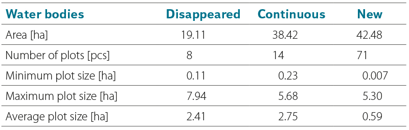
Fig. 4 shows the development of the landscape in the Výrovka source area from the mid-nineteenth century through the 1950s to the present. In the source area at Kochánov, a small water reservoir is currently designated as the source, from which the Výrovka flows out through a paved channel (Fig. 5a, b). The watercourse then continues in a straightened, overgrown channel through three smaller ponds (Figs. 3 and 6), the last of which (Bobr pond) has a dam located 2 km downstream from the Výrovka source. Fig. 7 documents the current state of the landscape in this area.
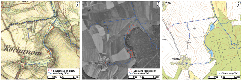
Fig. 4. Landscape changes in the Výrovka spring area, based on the 2nd Military Mapping (1852), historical orthophotomap from the 1950s, and BTM 10 (2024)
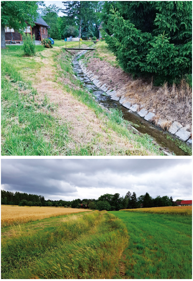
Fig. 5a, b. Current state of the landscape in the Výrovka spring area (July 2025)
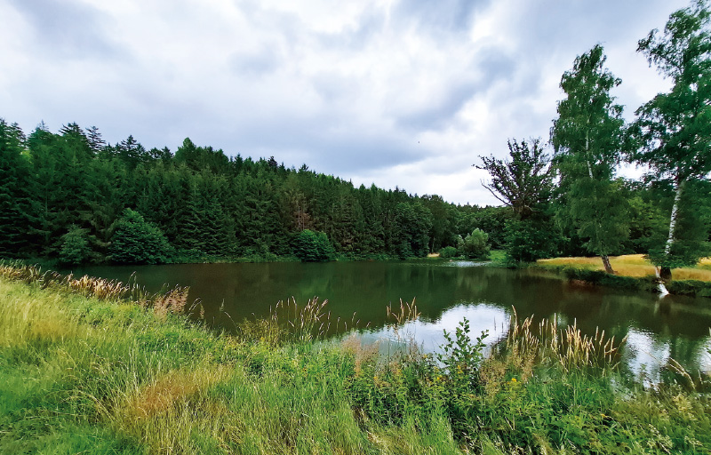
Fig. 6. The first pond on Výrovka (July 2025)
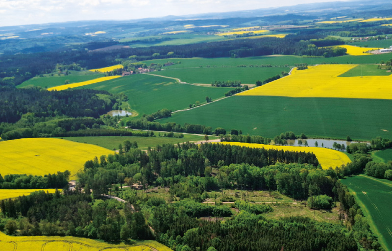
Fig. 7. Landscape in the Výrovka spring area up to Bobr (Beaver) pond (May 2025)
Over the next 4 km of the Výrovka, within the territory of Uhlířské Janovice, the following water bodies occur: Nový pond, the bathing pond, Hořejší pond, Holoubek pond, and the pond at the former Lucký mill (Fig. 8). The landscape around the former Lucký mill has undergone considerable changes from a water-management perspective. Extensive drainage of agriculturally used land has taken place, and the watercourses have been altered, including their straightening and deepening. The landscape development in this site from the mid-19th century through the 1950s to the present is shown in Figs. 9 and 10. These sources indicate that significant interventions in the watercourses have occurred: the location of the confluence of the Výrovka and Anenský stream has been changed, floodplain meadows have disappeared, and the landscape mosaic has become generally simplified. It should be emphasised that all these changes have taken place within the first 6 km of the Výrovka, and similar changes have also affected the tributaries of the Výrovka in this intercatchment. Combined with current climatic conditions, the above-mentioned changes in the landscape contribute to the periodic drying of the Výrovka channel and its small tributaries. The drying has a long-lasting character; initially it occurred only during summer, but in recent years it has begun as early as April and continues through September and usually also into October (Fig. 11a, b). In this site, the failure of drainage systems has led to the successional regeneration of a wetland headwater site on what is currently agricultural land (Figs. 12–14). However, this development is not the result of targeted management but rather of the inability to cultivate such waterlogged land using modern agricultural machinery.
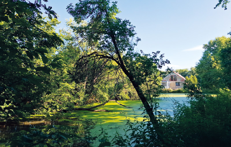
Fig. 8. Pond at the former Lucký mill (July 2025)
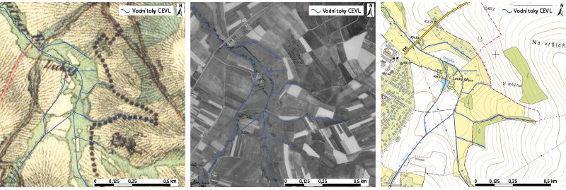
Fig. 9. Landscape changes in the area of the former Lucký mill, based on the 2nd Military Mapping (1852), historical orthophotomap from the 1950s, and BTM 10 (2024)
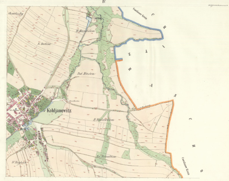
Fig. 10. Landscape in the area of the former Lucký mill on Imperial Imprint of the Stable cadastre (1839)
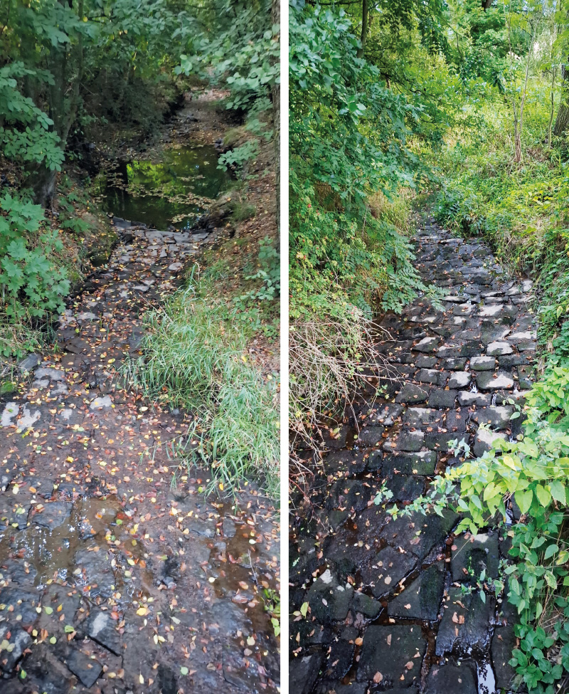
Fig. 11a, b. Dried-up riverbed of the Výrovka at the confluence with Anenský stream (September 2025)
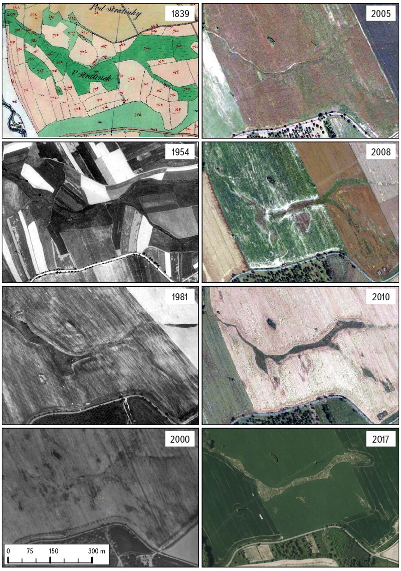
Fig. 12. Succession restoration of the drained site ‘‘U Stratinek’’ shown on the Stable cadastre (1839), historical orthophotomap from the 1950s, and archival orthophotomaps
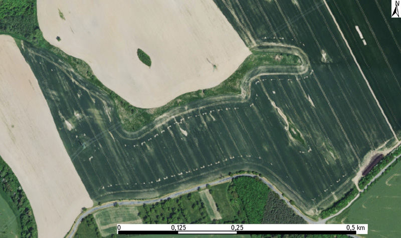
Fig. 13. Site ‘‘U Stratinek’’ on a current orthophotomap (2023)
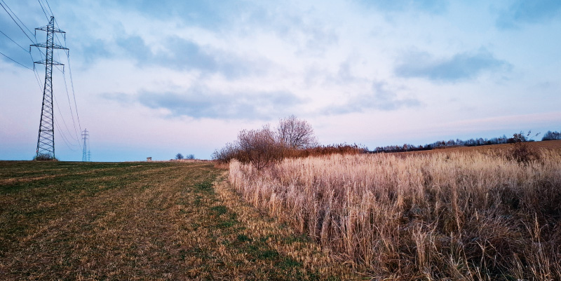
Fig. 14. Current state of the site ‘‘U Stratinek’’ (November 2025)
DISCUSSION AND CONCLUSION
In interpreting the development of water bodies, their specific use was not distinguished because definitions of a pond have differed between the past and the present. Today, there is a wide range of water body types in the landscape depending on their use, and there are also differences between the uses of water bodies that are designated as ponds. Historically, all artificially created water bodies provided with a dam or excavated by human activity were regarded as ponds. In the mid-19th century, the distinction between a reservoir (e.g. for fire protection, economic purposes, etc.) and a pond (a water body intended exclusively for fish farming) was not yet clearly defined. From this perspective, all water bodies shown on the maps of the 2nd Military Mapping and on the Imperial Imprints of the Stable cadastre can therefore be considered ponds [16, 17].
When interpreting the results in terms of the temporal stability of water bodies/ponds, it is necessary to take into account that the analysis compares only two reference states: the period of the 2nd Military Mapping and the present. Naturally, the extent of these areas has changed over time as a result of management; for example, a water body may have become silted up and later been restored. Thus, when historical water bodies/ponds are classified as disappeared or continuous, some of those considered may have disappeared in the interim and subsequently been restored. A continuous water body/pond is also a water body that is significantly smaller than it was in the past, but remains in its original location.
Under current climatic conditions, given the number of water reservoirs along the Výrovka, it is probably not possible to avoid the drying of stream channels; however, various landscape measures can increase water retention in the surrounding landscape. The restoration (revitalizion or renaturation) of watercourses appears to be necessary. In considering landscape changes in the headwaters, the historical locations of water-retention elements (wetlands, floodplain meadows, etc.) should also be considered, as their construction or restoration would be easier there and such elements would be more stable in the landscape. A general problem in the landscape is drainage infrastructure, both functioning and non-functioning, and it would be necessary to address this situation from a methodological or legislative point of view so that its function is beneficial for the water regime in the landscape. The current situation in the studied catchment, with a larger number of water bodies used for fish production and straightened sections of watercourses in the headwaters, is not particularly favourable for water retention in the landscape.
However, on the map of the 1st Military Mapping, ponds near Kochánov were located in similar places to those today (Figs. 4 and 15), but that time the watercourses meandered and were surrounded by floodplain meadows, and climatic conditions were also different from those today. The situation recorded on the 1st Military Mapping along the Výrovka in the area of Uhlířské Janovice shows more water bodies/ponds than the 2nd Military Mapping (Figs. 3 and 16). Here, near the former Lucký mill (if we can rely on the not entirely accurate depiction of the landscape), it appears that between the two military surveys, the watercourses within the floodplain at the confluence of the Výrovka and Anenský stream were modified (Figs. 9, 10, and 16).
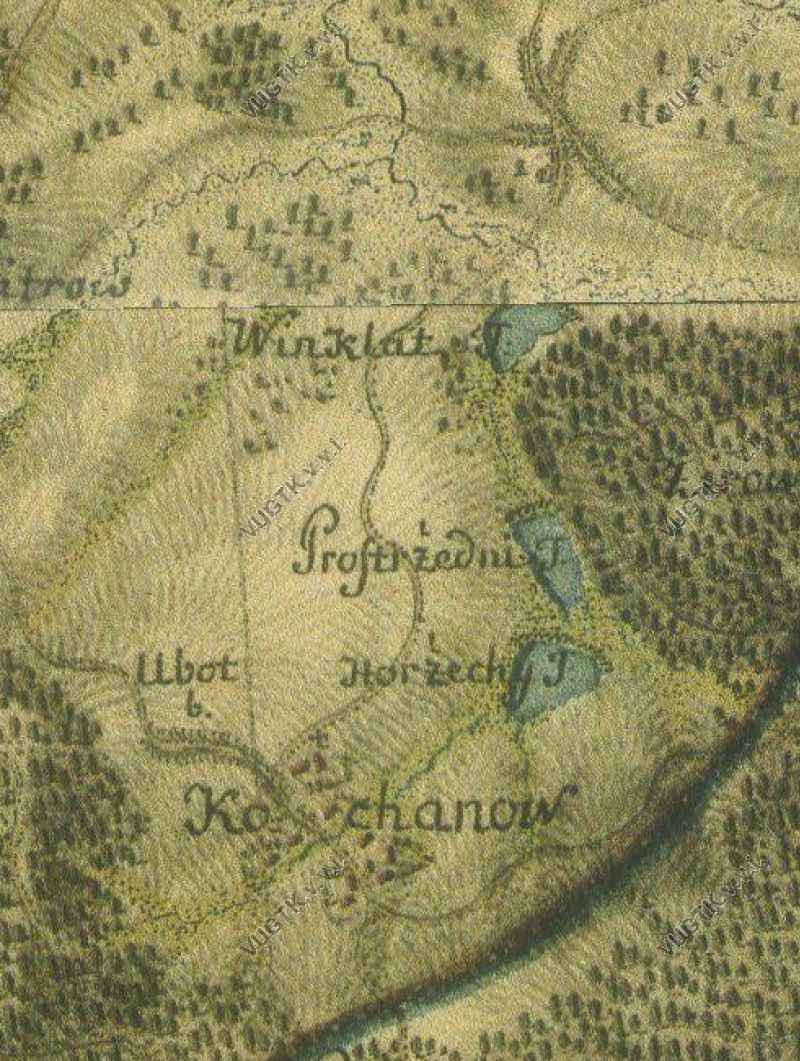
Fig. 15. Landscape in the Výrovka spring area on the 1st Military Mapping
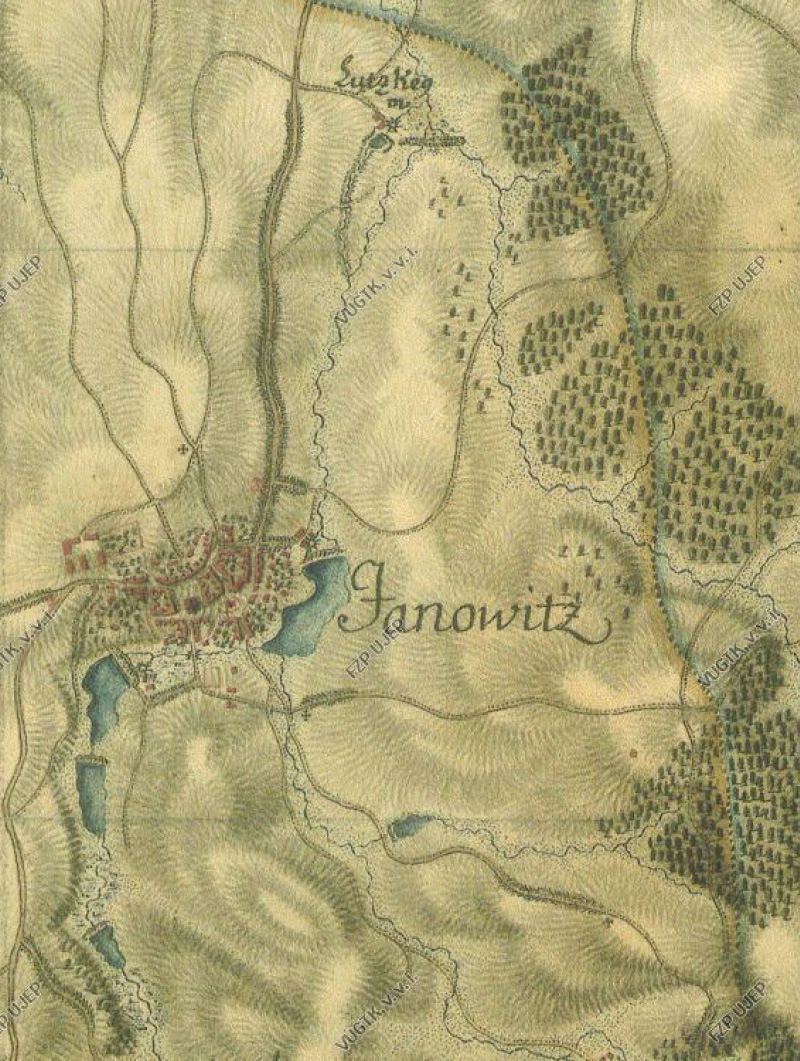
Fig. 16. Landscape in the area of Uhlířské Janovice village, including the former Lucký mill, on the 1st Military Mapping
Based on the interpretation of archival maps, it would be appropriate not only to propose but also to implement restoration measures with a positive impact on the water regime of the landscape in suitable locations. In particular, this should involve the revitalisation or restoration of small watercourses, including the restoration of their floodplains, where possible. Such measures should also form part of the response to the challenges posed by ongoing climate change. The above-mentioned measures should primarily lead to increased water retention in the landscape. They would also contribute to greater landscape biodiversity. In particular, headwater areas and the upper parts of catchments (in their natural state, without straightened and deepened channels) play an important role in adaptation measures to ongoing climate change, by increasing the landscape’s capacity to retain water and slow the onset of floods, and this role will probably become increasingly important in the future.
These measures are consistent with the EU Biodiversity Strategy for 2030 [18], which is a valid long-term plan for nature conservation aimed at halting ecosystem degradation and restoring biodiversity in Europe. The strategy includes a commitment to place at least 30 % of land and inland waters under legal protection. It also calls for increased efforts to restore freshwater ecosystems and the natural functions of rivers, including the restoration of at least 25,000 km of free-flowing rivers compared with the situation in 2020, when the EU Biodiversity Strategy for 2030 was adopted. As part of this strategic plan, the first-ever EU legislative document for the long-term restoration of nature in both terrestrial and marine areas of the EU was proposed and adopted, establishing binding restoration targets for specific habitats and species. This is the Nature Restoration Law 2024/1991 [19], which represents the first Europe-wide legally binding framework for ecosystem restoration. It responds to the current situation in which Europe’s nature is in alarming decline, with more than 80 % of natural habitats in poor condition. Its objective is to reverse the trend of biodiversity loss, increase landscape resilience, and strengthen ecosystems in order to support adaptation to climate change. In the area of wetland and freshwater ecosystems, it requires, among other measures, the restoration of at least 30 % of drained wetlands used for agriculture by 2030. Furthermore, each Member State is required to prepare its own National Nature Restoration Plan within two years of the regulation entering into force, specifying the timetable and scope of measures up to 2050 [19, 20].
In the Czech Republic, strategic objectives in the field of sustainable water management in the landscape are currently set out, for example, in the State Environmental Policy of the Czech Republic 2030 (with an outlook to 2050) [21]. Within Priority Axis No. 2, Protection of Natural Resources, emphasis is placed on improving the landscape’s retention capacity, restoring the natural water balance, and implementing integrated river basin management. The document sets commitments to increase natural water retention by 10 % and to restore at least 500 km of watercourses with natural channels by 2030.
Another related document is the Strategy for Adaptation to Climate Change in the Conditions of the Czech Republic [22]. The main declared objective of this strategy is to maintain the availability of water resources, increase the landscape’s retention capacity, and minimise the impacts of drought on ecosystems, the population, and the economy. Drought is identified as one of the main climate risks. This strategy is followed by the National Action Plan for Adaptation to Climate Change [23], which specifies measures for water retention in the landscape, the revitalisation of watercourses, the restoration of wetlands, increasing the share of permanent grasslands, and the introduction of soil-friendly land management practices.
The above-mentioned documents are largely theoretical in nature. They declare “useful and commendable” objectives, but without a direct translation into practice and without legal enforceability. An exception is the Nature Restoration Law of 2024, which represents the first Europe-wide legally binding framework for ecosystem restoration. In preparation for meeting the requirements of this European regulation on nature restoration (concerning free-flowing rivers and functional floodplains), the collection of background data began in advance within the project Passportization of Watercourses implemented from 1 May 2023 to 31 December 2025 and carried out by the Nature Conservation Agency of the Czech Republic. Its main objective was the field collection of hydromorphological characteristics of selected watercourses and the proposal of measures/management for watercourse sections to improve or protect their hydromorphological status. A total of 26,032 km of watercourses were selected for the passportisation, of which 23,665 km had been mapped by 31 October 2025. As of that date, the Výrovka is not included among the published outputs of the project, which are currently available through the Watercourses and Wetlands portal [24]. The main project output is a map and datasets relating to watercourse sections verified in the field. These sections are divided, with regard to their potential or need for revitalisation or restoration, satisfactory natural conditions, and limiting factors, into eight groups of “measures on watercourses”. During the passportisation, permanently dry sections of watercourses were also detected.
A large amount of data is therefore available that is suitable as an ideal basis for proposing specific measures in watercourse channels or for supporting the restoration or revitalisation of watercourses in the coming years. It is therefore to be hoped that the results of this project will indeed be used in practice and that further projects with a practical impact on landscape restoration in terms of water retention will be implemented, such as the revitalisation or restoration of watercourses, including the restoration of their floodplains, or the restoration and establishment of wetland habitats at suitable locations.
Acknowledgements
The article was written within the research of the Centre for Landscape and Biodiversity (TA CR No. SS02030018) with the support of internal grants of TGM WRI No. 3600.23/2024 and No. 3600.23/2025 (Research support – institutional support, Department 230).
