ABSTRACT
The growing demand for decentralized renewable energy sources has sparked renewed interest in harnessing the hydropower potential of small watercourses. This paper presents a two-stage methodology developed within the Pico-Hydropower project (TA CR, No. TK04030223), aimed at identifying and evaluating suitable locations for micro-hydropower installations in the Czech Republic. The first stage involves a nationwide spatial assessment of theoretical hydro-power potential (HPP) across all fourth-order catchments, based on a combination of digital elevation models (DMR 5G), interpolated values of mean annual flow (Qa), and calculated average channel head (H). The resulting geodatabase enables prioritization of catchments with above-average potential and serves as input for more detailed analyses.
In the second stage, a specialized software tool called SCR (Sklony_ČR) was developed to identify specific river reaches with usable head and flow. The tool integrates topographic and hydrological data with user-defined technical parameters (e.g., minimum head, flow rate, or desired power output) and allows for rapid screening of suitable locations without the need for extensive field surveys. The methodology was validated through pilot testing in the Otava catchment, confirming its practical applicability for regional energy planning, project development, and academic research.
The results show that the highest hydropower potential is concentrated in the northern and northeastern regions of the Czech Republic, particularly in the catchments of the Morava, Jizera, Úpa, Olše, and Lužická Nisa rivers. The combination of spatial modelling and interactive analysis offers a scalable and user-friendly approach to utilizing the previously overlooked potential of small streams, which can significantly contribute to the sustainable development of decentralized hydropower in mountainous and rural areas. In the next phases of the project, the methodology will be verified through demonstration studies, including legal and environmental assessments of selected locations.
INTRODUCTION
The use of renewable energy sources constitutes one of the main directions of current European and national energy policy [1, 2]. While most past investment has focused on large, centralised sources, interest is growing in decentralised, low-cost, and spatially dispersed solutions that enhance the energy self-sufficiency of local communities. This approach is also being applied in hydropower, particularly in the form of micro- and pico-hydropower plants that are capable of efficiently utilising even low hydropower potential on small watercourses.
In connection with ongoing climate change, the characteristics of precipitation and runoff regimes in the Czech Republic are also changing. Although total annual precipitation does not change significantly in the long term, there are substantial changes in its temporal and spatial distribution [3], as well as an increase in the intensity of short-term precipitation events, which are more frequent and extreme than in the past [4]. The proportion of intense precipitation events is increasing, and the interval between drought episodes and flash floods is shortening. These changes are reflected in the variability of flows in small watercourses and affect their dynamics, stability, and potential for energy utilisation.
Small watercourses (SWC) constitute a significant part of the river network in the Czech Republic, and their distribution also covers areas where other renewable energy sources – such as wind or photovoltaic energy – are not sufficiently effective or feasible. Although their flows and heads often do not allow for direct energy utilisation in the sense of conventional hydropower, the overall SWC hydropower potential can be significant in the context of decentralised energy systems. For its effective use, however, it is essential to have appropriate tools for the systematic identification of suitable locations and for the preliminary technical and energy assessment of their parameters.
The Pico-Hydropower project (TA CR, No. TK04030223) responds to the challenge of efficiently utilising SWC by developing a methodology for determining their hydropower potential. This article builds on a previous article in VTEI [5], in which a methodology for interpolating flows in catchments without direct measurements was addressed, forming a key input for potential calculations. In the previous phase of the project, the theoretical hydropower potential (HPP) of all fourth-order catchments in the Czech Republic was calculated using a combination of a digital elevation model and interpolated values of mean annual flow (Qa). The result is a spatial layer that allows for the prioritisation of catchments with above-average potential, serving as an initial filter for more detailed analyses at the level of specific stream sections [6].
Based on accuracy testing of different types of digital elevation models (DMR 4G, DMR 5G, and their derivatives) [7], a specialised tool, SCR (Sklony_ČR), was subsequently developed within the project, enabling the interactive selection of specific river reaches with usable potential. This tool combines spatial data on heads and flows with user-defined technical parameters (e.g., desired output or minimum head) and allows for the rapid identification of suitable locations for micro-hydropower utilisation without the need for extensive field surveys.
The aim of this article is to present a methodology for locating suitable river reaches of SWC using a spatial HPP database for fourth-order catchments and the SCR tool. It also demonstrates how hydrological catchment analysis can be linked with the technical design of specific sites for the installation of micro-hydropower sources.
METHODOLOGY
The first step in assessing the exploitable hydropower potential of watercourses was the spatial delineation and quantitative evaluation of all fourth-order catchments in the Czech Republic. This catchment level was chosen as an optimal compromise between hydrological homogeneity and spatial detail, and it also aligns with the established catchment classification structure used in management databases (e.g., DIBAVOD, CEVT, internal TGM WRI database).
Data inputs
The following primary datasets were used for the calculations:
- Digital elevation model DMR 5G (ČÚZK): a raster with a horizontal resolution of 5 m and a Z accuracy ≤ 0.2 m in open terrain. It is used to determine stream gradients.
- Vector network of watercourses – coarse segments from the DIBAVOD database: represents the main axes of watercourses. The HLGP_ID identifier was supplemented to ensure that the river reaches are consistent with the fourth-order catchment layer.
- Fourth-order catchment polygons: spatial units from the internal TGM WRI database, unified with watercourse data.
- Specific runoff map (qa) in units [l · s-1 · km-2]: an interpolated layer created using a geostatistical kriging method with external drift [8] based on selected CHMI profiles with long-term flow records. The layer was calibrated against the overall water balance and verified in the pilot Otava catchment area [5].
Although the main focus of the project was on SWC, the basic hydrological characteristics were systematically determined for all fourth-order catchments in the Czech Republic. For each catchment, the average stream head and the mean annual flow Qa (as an indicator of long-term water availability) were calculated, and these values were subsequently used to derive the exploitable HPP. This approach enabled not only a comprehensive assessment of all fourth-order catchments but also a subsequent detailed comparison with results for selected SWC.
Methodology for determining basic parameters (H, Qa, HPP)
The following text describes the procedure for determining the exploitable HPP of watercourses in the Czech Republic. The basis is a spatial division into fourth-order catchments and the use of a combination of geospatial datasets, a digital elevation model, and hydrological data. The steps described led to the creation of a unified database containing, for each catchment, values of the average stream head (H), mean annual flow (Qa), and derived hydropower potential (HPP – P), which is the outcome of the project and is available in [7].
a) Average head of the main stream (H)
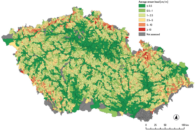
The value of H was derived from the elevation difference between the start and end of the so-called main stream, defined as the longest connected section of the stream within a given fourth-order catchment. In the database, the main stream line is divided into reaches “from tributary to tributary,” or in the headwater section “from the source to first confluence.” The start and end points of each segment within a catchment were determined by intersecting the main stream line with the drainage divide. The elevation values of these points were then extracted from the DMR 5G digital elevation model raster using spatial analysis tools. The head was expressed either in metres (total difference) or as the average longitudinal slope in cm · m-1, or as a percentage (Fig. 1).
 Fig. 1. Mean head of rivers in the Czech Republic (H) – fourth-order catchment scale
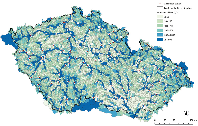
b) Mean annual flow (Qa)
The mean annual flow Qa was determined for all fourth-order catchments in the Czech Republic. The primary source was a map of specific runoff isolines qa [l · s-1 · km-2] [9, 10]. This map was first vectorised and then reclassified using linear interpolation, with the aim of refining the intervals between individual qa values compared to the original printed map, thereby obtaining a more detailed spatial distribution. Reclassification was carried out in several intervals: in the range 1.16–9 l · s-1 · km-2 a step of 0.5 was used; in the interval 9–20 l · s-1 · km-2 a step of 1; and in the interval 20–30.5 l · s-1 · km-2 a step of 2. Practically, this means that, for example, after the minimum value of 1.16 the next value was 1.5, followed by 2.0, 2.5, … up to 9.0 l · s-1 · km-2 Most of the Czech Republic falls into this lowest category, whereas the interval 9–20 is characteristic mainly of mountainous areas, and values of 20–30.5 occur only sporadically (e.g., in the Krkonoše Mountains).
The values of qa were assigned to individual fourth-order catchments based on the intersection of each catchment polygon with the vectorised map of isolines. In cases where a catchment extended across several qa intervals, the resulting specific runoff was calculated as an area-weighted mean. Subsequently, the mean annual flow Qa [l · s-1] was computed for each catchment according to the following equation:

where:
A is the catchment area [km²]
If a catchment was split into multiple parts, the resulting flow was determined as the sum of the partial runoff values.
The resulting Qa values were further calibrated using data from 137 limnigraph stations operated by the Czech Hydrometeorological Institute (CHMI).
The stations were selected so as to avoid excessive spatial density of profiles and to ensure that each station represented a sufficiently large upstream catchment area. This approach ensured uniform coverage of the Czech Republic and, at the same time, reduced unnecessary workload associated with very small catchments.
Calibration consisted in comparing the calculated values of Qa with the measured flows at the gauging-station profiles and subsequently adjusting them. The differences were apportioned across the individual fourth-order catchments proportionally to the magnitude of the originally derived runoff values from the isoline map. In this way, systematic biases were removed and the reliability of the Qa estimates improved, as shown in Fig. 2.
Fig. 2. Mean annual streamflow (Qa) – fourth-order catchment scale
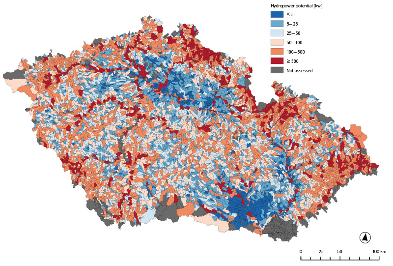
c) Hydropower potential (P)
To estimate the theoretical hydropower potential P [kW], a simplified working equation was used:

where:
H is elevation difference [m]
The coefficient 6 accounts for unit conversion and gravitational constant
Qa represents mean annual flow [m³·s-1]
At this stage of the calculation, turbine efficiency is not considered, so the resulting value represents the gross theoretical power, primarily useful for comparing the relative potential between catchments.
This simplified relationship is based on the general equation derived from Bernoulli’s law for the potential energy of a water column:

where:
ρ is water density (1,000 kg · m-3)
g acceleration due to gravity (9.81 m · s-2)
Q mean annual flow [m³ · s-1]
H elevation difference [m]
η efficiency (not applied at this stage of the calculation)
The resulting spatial layer, containing the attributes of mean head (H), mean annual flow (Qa), and derived hydropower potential (HPP), enables a uniform and comparable assessment of all fourth-order catchments in the Czech Republic (Fig. 3). This layer serves as the basis for subsequent analyses and forms the primary input for the next phases of hydropower potential assessment.
Fig. 3. Estimation of theoretical hydropower potential (P) – fourth-order catchment scale
Identification of subsections using the SCR tool (Sklony_ČR)
While the calculation of hydropower potential for fourth-order catchments allows for the spatial identification of areas with a higher probability of suitable locations, more detailed assessment of specific stream sections is necessary for subsequent use. For this purpose, the SCR tool (Sklony_ČR) was developed within the project – a specialized software tool for the localization and assessment of the hydropower potential of stream sections.
This application is designed as a standalone executable (*.exe) and was developed in the C++ programming language. It is built on a geodatabase generated from the digital elevation model of the Czech Republic, interpolated flow characteristics, and topologically connected stream lines. The tool allows users to search for and filter specific stream sections in the user interface based on defined technical parameters, and subsequently to visualize and analyze them according to the specified criteria.
The operation of the SCR tool is based on a pre-processed geodatabase of sections with usable head, created using a semi-automatic detection method from DMR 5G. This database contains the following types of data:
- Slope lines (so-called gradient segments)
These are vector segments (primary stream sections) traced along the stream axis, created by segmenting the main line based on significant changes in slope. The segments have a defined start, end, length, elevation difference (∆H), and calculated average slope. Refinement was performed using an algorithm that detects inflection points in the elevation profile of the line derived from DMR 5G.
- Flow characteristics (Qa)
Each segment was assigned an estimated mean annual flow (Qa) based on spatial interpolation from the specific runoff map (see section Methodology for determining basic parameters).
- Identifiers and technical attributes
Each segment carries a unique ID (UTOKH_ID), a reference to the corresponding catchment (IDVT), and the stream segment ID (HLGP_ID).
Additionally, the database contains calculated values for:
- segment length (m),
- elevation difference – minimum head (m),
- minimum energy potential – estimated power (kW).
User interface and search algorithm
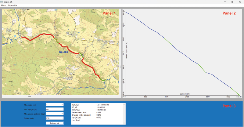
For the presentation of the SCR user interface [11], the Spůlka (HLPG_ID 108020180) was selected. The application is designed as a guided workflow for selecting river reaches, reflecting the decision-making logic applied in the preliminary assessment of hydropower potential. In the first stage, the user defines the area of interest by selecting a fourth-order catchment or a specific primary stream section.
User-defined technical criteria are subsequently applied to the selected river reach. Filters include minimum segment length (50, 100, 250, and 500 m), minimum elevation difference (1–5 m in 1 m steps), minimum flow value Qa (0.1–0.5 m³ · s-1 in 0.1 m³ · s-1 steps), and optionally a direct requirement for the resulting power (1–5 kW in 1 kW steps). The combination of these parameters allows for the pre-exclusion of segments with insufficient conditions and streamlines the search for suitable candidate sites.
The results are made available to the user as both a spatial visualization and a tabular output, as shown in Fig. 4. In the map window, suitable segments are highlighted in different colours and can be clicked to access detailed information. It is also possible to display an interactive longitudinal stream profile, where the segments are clearly marked, including their parameters and spatial location. A table with key attributes (length, head, Qa) is also available as a text. In this way, the application supports rapid identification of stream reaches that meet the specified parameters, requiring minimal prior knowledge from the user. The outputs serve as a basis for subsequent project preparation steps or for comparative analyses at the regional level.
Fig. 4. Identification of river reaches according to the defined parameters (panel 1), longitudinal profile of the selected river with delineated reaches (panel 2), and input parameters with tabular values of the selected reach (panel 3)
RESULTS
The database of hydropower potential at the level of fourth-order catchments provides a unified overview of the distribution of HPP in small watercourses and allows for rapid identification of regions with higher values for more detailed subsequent assessment. Thanks to visualization in maps and tables, preliminary analysis can be carried out without the need for extensive field surveys. The database is complemented by the Sklony_ČR application, which allows detailed analysis of individual river reaches based on user-defined technical parameters (e.g., head, flow, power). Results are presented as maps and tables with longitudinal profiles of the streams, facilitating the identification of sites with actual energy potential. The combination of the database and the application thus provides a comprehensive tool – from broad-scale assessment to detailed localization of suitable reaches.
For demonstration purposes, a procedure was carried out where fourth-order catchments with a mean annual flow below 1 m³·s-1 were excluded from the analysis. The remaining catchments were subsequently aggregated to the level of third-order catchments, and their hydropower potential values were summed. Simultaneously, the resulting values were normalized by catchment area, allowing comparison of individual units independently of their size. This procedure provided an overview not only of the absolute total potential but also of its relative intensity per unit area.
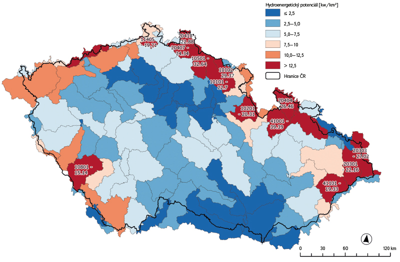
Fig. 5. Hydropower potential of third-order catchments recalculated per unit area (km²)
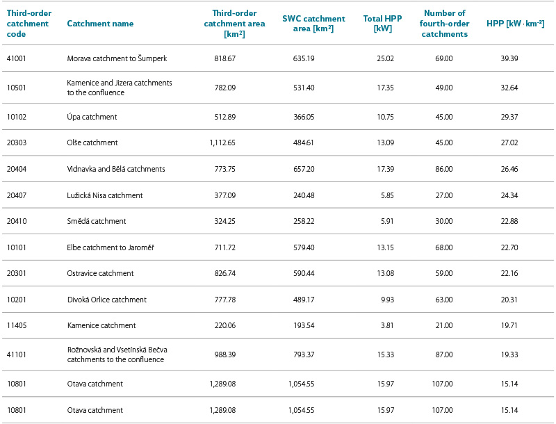
The results showed that the highest hydropower potential is concentrated primarily in the northern and northeastern parts of the Czech Republic. Notable contributions come from the Morava catchment to Šumperk, the Kamenice and Jizera, the Úpa and Olše catchments, as well as smaller catchments such as the Lužická Nisa, Smědá, and Vidnavka with Bělá. Higher values were also identified in the mountainous and foothill areas of the Krkonoše, Jizera Mountains, Jeseníky, and Beskydy, where the combination of higher heads and more stable flows creates favourable conditions for the development of micro-hydropower. An overview of the most significant catchments is presented through a map output and a graph, showing the spatial distribution of potential across the Czech Republic. The basic characteristics are summarised in Tab. 1.
Tab. 1. Third-order catchments with the highest hydropower potential
The created database and the SCR (Sklony_ČR) application find use not only in the assessment of hydropower potential but also in other areas. For public authorities and local governments, they can serve as a basis for energy strategies, strategic documents, and spatial planning. Watercourse managers can use them for planning the management of water resources and for evaluating the impacts of climate change. Investors and project designers are provided with a tool for the rapid selection of suitable sites and for streamlining project preparation, thereby reducing survey costs. The academic sector can use them for modelling, research, and teaching. Thanks to these possibilities, both outputs represent a versatile resource for integrating energy, water management, and environmental planning.
DISCUSSION
One of the key advantages of the presented approach is its two-tiered structure, which allows linking a nationwide mapped assessment of the hydropower potential of fourth-order catchments with the local identification of specific river reaches based on user-defined technical parameters [12, 13].
This approach effectively combines a high level of standardisation and clarity in the mapping phase with the possibility of detailed assessment of specific sites using the SCR application. Users can readily identify catchments with above-average HPP from the map outputs (e.g., specialised Nmap) and then focus, via the software tool, on pinpointing suitable reaches with particular head, flow, and power characteristics. This eliminates the need for manual inspection of an entire watercourse or cartographic analysis within a GIS environment.
The proposed approach has a high degree of practical applicability for a variety of target groups. For public authorities (municipalities, regions, and watercourse managers), it provides an accessible basis for strategic planning of renewable energy utilisation and can be applied in the preparation of spatial-energy concepts. Designers and investors can use the software tool for a rapid assessment of sites prior to the preparation of a technical study, thereby significantly shortening the project’s preparatory phase. The tool is usable without advanced GIS expertise, which extends its applicability to smaller organisations or municipalities lacking specialised support. Its practical utility was confirmed during pilot tests in the Otava catchment, where suitable sites were successfully identified.
It is, however, important to emphasise that the approach carries certain methodological and technical limitations. One of the key constraints is the uncertainty in the estimated flows, which are derived from the interpolation of the specific runoff isoline map [10] and calibrated against measured profiles. In locations without available measurements, high accuracy of flow data cannot be guaranteed [14], which may affect the reliability of the estimated power output [15]. At the current stage of the study, ecological and property-related aspects, which are critical for realistically assessing a site’s suitability for a small hydropower installation [16], were also not included. These aspects (e.g., protection zones, migration barriers, conflicts with spatial planning) should be evaluated in subsequent steps of project preparation.
Nevertheless, it can be concluded that the combination of robust map-based analysis and a targeted software tool has produced a practical and highly scalable approach, which expands the possibilities of utilising hydropower potential in small watercourses and contributes to the modernisation of planning for small renewable energy sources in the Czech Republic. A further outcome supporting practical implementation will be delivered in the form of a validated technological approach (Ztech), where several demonstration studies will be tested. In several fourth-order catchments, a pilot assessment will be carried out for the construction of the smallest-scale hydropower plant, complemented by a review of land ownership issues and an evaluation of environmental aspects, with particular emphasis on stream connectivity. The subsequent outcome will also include a preliminary assessment of the economic feasibility of selected options, allowing a more comprehensive evaluation of the suitability of sites for the installation of small hydropower stations. This output will serve as an example of the application of the proposed methodology under real conditions and as a basis for verifying the feasibility of individual options.
CONCLUSION
The presented approach for assessing the hydropower potential of small watercourses in the Czech Republic combines a nationwide spatial evaluation with a detailed analysis of specific river reaches using the SCR tool. This two-tiered methodology enables the efficient identification of sites with exploitable energy potential even without direct flow measurements, thereby significantly shortening the initial phase of project preparation. The applicability of this approach has been validated using data from across the Czech Republic as well as in the pilot area of the Otava catchment.
The proposed tool and methodology provide a practical basis for a territorial screening of sites suitable for the implementation of micro-hydropower installations, particularly in areas where other renewable energy sources are not technically or economically feasible. This approach will be further developed within a Ztech type outcome – a validated technological process – which will focus on assessing the real-world feasibility of constructing micro-hydropower facilities at selected sites and on modelling operational regimes, including water storage and distribution.
This article does not discuss other specific circumstances related to the actual implementation of small hydropower stations, such as construction constraints, legislative procedures, economic costs, and operational risks. These factors have a crucial impact on the ultimate feasibility of projects and should therefore be considered in subsequent phases of project preparation. The approach presented here is primarily focused on the mapping and analytical assessment of potential, serving as an initial step in the systematic identification of suitable sites.
In summary, it can be stated that the combination of spatial modelling, available hydrological data, and a simple tool for technical assessment can make a significant contribution to identifying the hitherto overlooked potential of small watercourses and support the sustainable development of decentralised renewable energy in the Czech Republic.
Acknowledgements
This article was supported by the Technology Agency of the Czech Republic, project No. TK04030223, Determination of the Hydropower Potential of ‘Pico-Hydropower’ under Current and Predicted Climatic Conditions in the Czech Republic, and by institutional support from the Ministry of Agriculture (MZE-RO0223).
