ABSTRACT
The construction of weirs on rivers affects the dynamics of groundwater levels. The weir built on the river Slaná in the year 2010 between the village of Abovce and Chanava brought the opportunity to study such impact due to preexisting groundwater monitoring wells of the Slovak Hydrometeorological Institute. to verify the impact of the constructed weir on groundwater dynamics in the area, records of weekly data were used ranging from 1986 to 2018. In addition, the spatial range of influenced areas was carried out using geographical information systems, and spatial interpolation techniques were used. The results showed that immediately after the construction of the weir, the groundwater level rose significantly.
INTRODUCTION
The construction of weirs and other works damming watercourses are common practice in the world due to the effectivity of the water hydroenergetic potential. In the 2000s have been built several small hydro powerplants practically in all main Slovak river catchments (Váh, Slaná, Orava, Poprad, Nitra, Hron, Hornád) [1]. The motivation was to change the energetic mix of the Slovak republic from mostly carbon-based to renewable sources [2]. However other environmental, as well as hydrological aspects of the proposed energetic solution, has not been sufficiently taken into account in the landscape planning phase [3]. This has been proved in the actualized strategic document of the Ministry of the environment of the Slovak republic by a decreased number of the river profiles that could be potentially used for future river weirs [4].
However, if the planning process of the future river weirs should be environmentally acceptable, it is necessary to base an authorization process on the scientific datasets and information that are publicly presented.
The paper deals with groundwater dynamics in the Slaná river basin influenced by a river weir constructed in 2010 near Abovce (Southeast Slovakia). Since the Slovak hydrometeorological institute has continuously recorded groundwater levels before and after the weir construction by nine monitoring wells in the area, is the paper an exciting contribution allowing insights into groundwater dynamics influenced by weir construction.
The general objective of this study was to describe and quantify the impact of the constructed weir, on the groundwater table by using directly measured data by groundwater monitoring wells. Specific sub-objectives are:
1) to estimate impact of weir construction on groundwater levels of nearest monitoring wells,
2) spatial influence of the weir construction on groundwater levels in the quaternary groundwater body (GWB) of the Slaná river (SK1001100P).
MATERIALS AND METHODOLOGICAL APPROACH
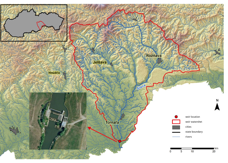
This study was conducted in the river Slaná watershed in Slovakia. The Slaná river is located in the southern part of central Slovakia, its spring is in Stolické vrchy. Slaná river is a mid-altitude river with a rain-snow outflow regime. The weir constructed in 2010 on the river Slaná is located between the villages of Abovce and Chanava and 10 km south from the city of Tornaľa (Fig. 1) in the river kilometer 4.7. The created weir has a maximum usable gradient of 3.2 m. The weir captures a watershed of an area of 1,821 km2. The purpose of the weir is hydroenergetic with an installed power of 0.5 MW.
 Fig. 1. Localization of the studied watershed and weir near Abovce village; the Upper left figure depicts watershed localization within the Slovak Republic
The groundwater underlying the weir belongs to the SK1001100P groundwater body (Fig. 2). It is characterized as formation of intergranular aquifer of the alluvial sediments of the Slaná river and its tributaries. The water body SK1001100P has an area of 140.24 km2. The water collector is formed mainly from alluvial and terrace gravel, sand gravel, sand, proluvial sediments, which are characterized by high flow rates [5]. The geological composition of the groundwater body (GWB) mainly consists of fluvial sediments with some other sediments far more upstream [6]. In the affected groundwater body, the Slovak hydrometeorological institute operates a state observation network from which we selected 9 monitoring wells for this study (Fig. 2). These monitoring wells are listed in Tab. 1.
Fig. 2. Quaternary groundwater body (GWB) of the Slaná river (SK1001100P); GWB consists of fluvial sediments (88 %) and other unconsolidated sediments and rocks (7 %), chemical sediments (2 %) and aeolian sediments (3 %) [6]; measuring objects (wells) are marked with a red dot and object number according to the Slovak hydrometeorological institute database
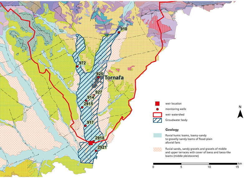
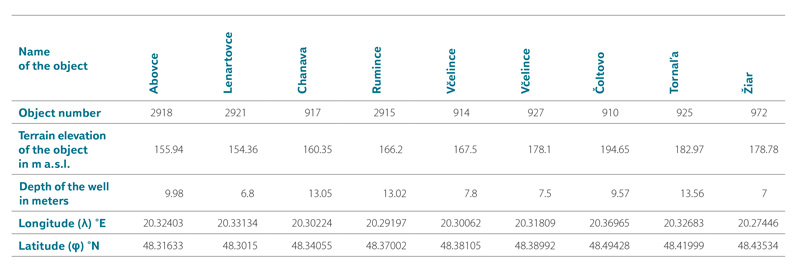
Tab. 1. Localization of the monitoring wells (objects) used in the study
Dataset of groundwater level altitude with weekly measurement were used and 5 time periods were evaluated. The whole time period used in the study was from 1986 to 2018 and contains 1,670 weekly records. Long term period before the construction of weir (1986–2009, 1,200 weekly records) in the study is named as “Before 2”, the shorter time period before weir construction (2002–2009, 417 weekly records) in the study is named as “Before 1”, the same time period after the construction of weir (2011–2018, 418 weekly records) in the study is named as “After 1”, and a combination of the periods is named “Before 1 + After 1” (2002–2018, 887 weekly records).
The data were organized into hydrological years (November to October), not into calendar years. The dataset was first tested on normal distribution by Shapiro–Wilk test [7], then the time periods were compared. The annual median data were tested on presence and direction of trends by Mann-Kendall test [8]. Data homogeneity was tested by Pettitt´s test [9], Standard normal homogeneity test (SNHT) [10] and Buishand´s test [11], with significance level of 0.05 and confidence level of 95 %.
GIS spatial interpolation method SPLINE was used to interpolate the difference of median values of groundwater levels for the time period for (1986–2009) and for (2011–2018) (Fig. 5).
RESULTS
Changes in groundwater level after weir construction near the Abovce weir
Detailed groundwater level changes have been studied on two monitoring wells (2918 – Abovce, 917 – Chanava) nearest to the Abovce weir. However, since the monitoring well 2918 – Abovce is situated only 416 meters above the incremented weir, we provide detailed statistics of groundwater level at this monitoring point in Tab. 2.
Tab. 2. Statistical characteristics of groundwater levels for measuring object 2918 – Abovce; values are in groundwater level elevation in meters above sea level [m a.s.l.]; period “Before 2” represents the whole available monitoring period of groundwater level previous to weir construction, “Before 1” represents 7 year long period previous to weir construction, as well as “After 1” represents the same long period after the weir construction; “Before 1 + After 1” represents a period of 7 years before and 7 years after the weir construction
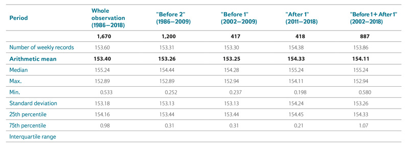
By applying median values and time-identical 7year intervals (“Before 1 + After 1”), it is evident an increase of the groundwater level up to 1.08 m. A significant increase has been recorded also in maximum and minimum groundwater levels. Tab. 3 lists all evaluated objects and the calculated difference between the time periods “Before 1” and “After 1”. It is evident that the construction of the weir impacted the nearest monitoring wells by evaluation of water level difference. Objects 2918 – Abovce and 917 – Chanava are the most affected. Their distance from the weir is 416 meters by the object 2918 – Abovce and 3,036 meters by the object 917 – Chanava.
Tab. 3. Overview of difference in median, max, and min between time periods “Before 1” (2002–2009) and “After 1” (2011–2018) for all measuring objects used in the study (depicted in Fig. 2); values are in groundwater level difference in meters
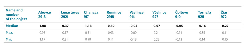
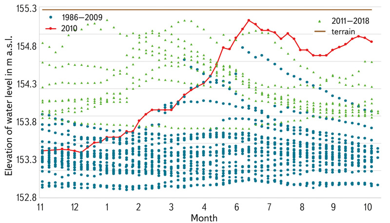
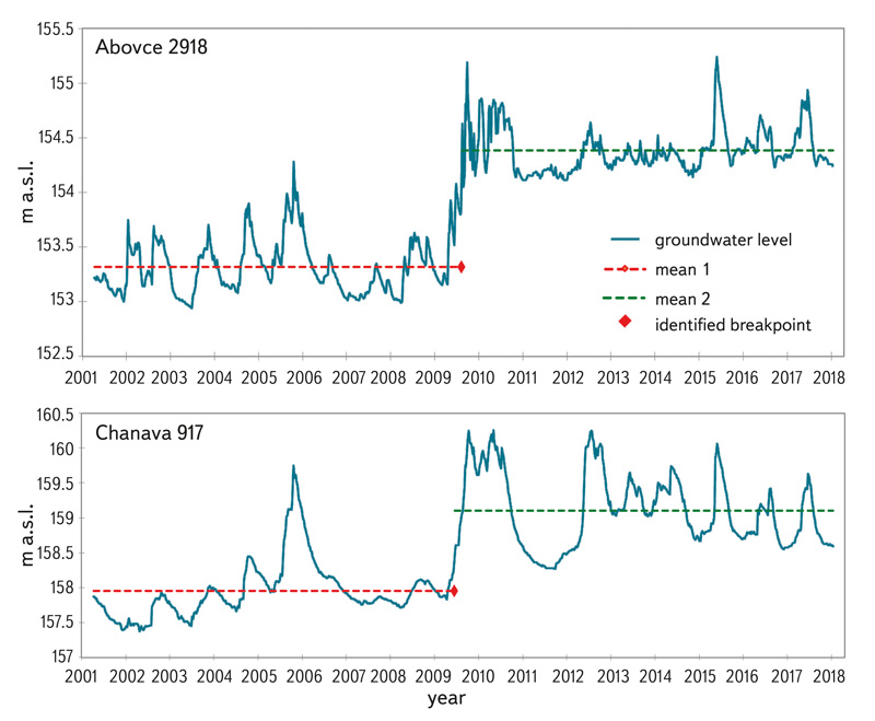
Fig. 3 and 4 show all weekly average groundwater level data measured in the most affected objects. The influence of the river weir on water level is evident at both stations. The red line in Fig. 3 and 4 depict the dynamics of the water level increase in the year 2010 when weir construction was completed. It is obvious that the groundwater level rose immediately after weir construction and remained higher in comparison to the reference period
1986–2009 in both monitoring wells.
Fig. 3. Difference of the weekly records of the groundwater levels in the period “Before 2” (period 1986–2009 before the construction of the weir) and “After 1” (period 2011–2018 after the construction of the weir) on the measuring object 2918 – Abovce (distance 416 m of the weir); the red dotted line depicts the increase of the groundwater level in 2010 when the weir was accomplished; brown line at 155.3 m a.s.l. represents ground
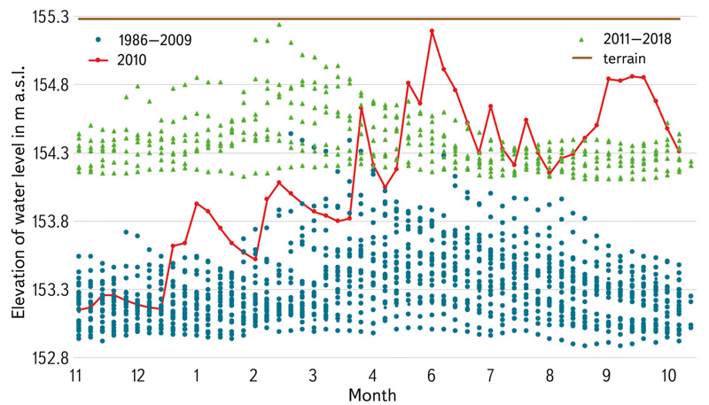
Fig. 4. Difference of the weekly records of the groundwater levels in the period “Before 2” (period 1986–2009 before the construction of the weir) and “After 1” (period 2011–2018 after the construction of the weir) on the measuring object 917 – Chanava (distance 3,036 m of the weir); the red dotted line depicts the increase of the groundwater level in 2010 when the weir was accomplished; brown line at 160.5 m a.s.l. represents ground
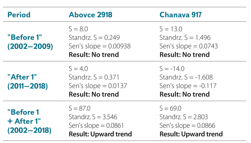
The results of groundwater level data subjected to trend analysis are shown in Tab. 4. At the time period “Before 1 + After 1”, a statistically significant upward trend is evaluated at objects 2918 – Abovce and 917 – Chanava. However, when the time periods “Before 1 + After 1”, were evaluated individually, a statistically significant trend was not found.
Tab. 4. Overview of Mann-Kendall trend test analysis results
Subsequently, in the case of time period “Before 1 + After 1”, data homogeneity test was also performed. Pettitt´s test, Standard normal homogeneity test (SNHT) and Buishand´s test were applied. All tests identified a break point at the beginning of 2010, when the weir in Abovce was put into operation (Tab. 5).
Tab. 5. Results of homogeneity test
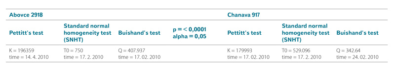
The same image is provided by the graph with the identified break point, as a result of Pettitts test, Fig. 5. The change in mean values of groundwater level is clearly visible, together with the identified breakpoint.
Fig. 5. Pettitt change point detection for groundwater elevation levels in time period “Before 1 + After” on the measuring object 2918 – Abovce and object 917 – Chanava
Spatial extent of Abovce weir influence on groundwater level in quaternary groundwater body of the Slaná river
Fig. 6 clearly shows that the highest difference in groundwater elevation is located right near the constructed weir and by the monitoring wells. Change in groundwater levels in quaternary water body vary from 0.21 m near Rumince monitoring well (2915) to 1.3 m around the constructed weir (monitoring well 2918 Abovce). A relatively high increase in groundwater levels was also observed on monitoring well 917 Chanava at a distance of 3,036 m from the Abovce weir. From the spatial point of view, the river weir of Abovce increased groundwater levels up to 1.3 m on the area of 15.25 km2 and up to 0.21 m to 0.4 m on the area of 38 km2. Thus, the Abovce river weir influenced almost 26 % of the waterbody SK1001100P area (an increase of groundwater levels more than 0.21 m). Groundwater levels increase more than 1.1 to 1.3 m was recorded on 11 % of the water body area.
Fig. 6. The difference of groundwater levels for time periods 1986–2009 (“Before 2” – before the construction) and 2011–2018 (“After 1” – after the construction) in the quaternary waterbody of the Slaná river

DISCUSSION AND CONLUSION
The rise of the groundwater level was an expected consequence of constructing a weir on the Slaná river. The rate of increase (up to 1.3 m near constructed weir) of the groundwater level is probably due to the geological conditions at the area, which is formed mainly by Quaternary sediments as stated in [6].
However, quaternary sediments are prone to anthropogenic contamination and pollution [12]. Based on the results presented in the work, it is evident that the construction of even a relatively small weir has a regionally significant impact on the groundwater level. It depends, of course, on the configuration of the terrain, the geological subsoil, and the characteristics of the weir construction structure itself [13]. Nevertheless, in the context of increasing drought risk in the studied area [14] increase in the groundwater levels due to the construction of the Abovce weir could be stated as potentially beneficial for agriculture.
On the other hand, we must not neglect the issue of potential groundwater pollution through industrial activity and agricultural fertilizers [15]. Also, the risk of leaching toxic substances from illegal and historically forgotten landfills can be a risk [12, 16, 17]. Historically, such substances were often buried in pits near farms or the vicinity of municipalities, and no evidence was kept [18]. This concern is valid, as the size of the area on which the groundwater level has increased by more than 1 meter is 15.25 km2 and includes the cadastral territory of four municipalities. By comparison areas of elevated groundwater level with the Ecological Information System load [19], there is only one potentially risky location in the most affected area registered as a former gas station. However, it is located in the C register, containing records of rehabilitated and reclaimed sites that do not pose any danger. Another danger is the increased level of underground water reaching deep approx. 1 m below the surface (near the villages of Chanava and Abovce), easily reachable by foot construction activities during which toxic substances can leach into groundwater [20]. There may also be a risk of groundwater contamination by oil products in accidents of construction machinery and technology [21]. The above aspects should local and regional authorities to take into account in the process of permitting new buildings activities. The contribution showed not only the significant influence of the construction of the river weir on the water level in the Quaternary groundwater body of the Slaná River (SK1001100P), but also on risks that should be addressed in the future.
Acknowledgements
This research was funded by the Scientific grant agency of the Ministry of Education, Science, Research and Sport of the Slovak Republic and Agency for support research and development within projects VEGA No. 1/0392/22 “Zraniteľnosť vybraných prírodne a antropogénne narušených ekosystémov vo vzťahu k prebiehajúcej zmene klímy (Vulnerability of selected natural and anthropogenically disturbed ecosystems in relation to ongoing climate change)” and APVV-21-0224 “Dynamika biometeorologických a ekohydrologických tokov vo vybraných lesných ekosystémoch ovplyvnených rôznymi disturbančnými faktormi (Dynamics of biometeorological and ecohydrological flows in selected forest ecosystems affected by various disturbance factors)”.
The Czech version of this article was peer-reviewed, the English version was translated from the Czech original by Environmental Translation Ltd.
